
Colorado Plateau


The Colorado Plateau, also known as the Colorado Plateau Province,
The Colorado Plateau is largely made up of high desert, with scattered areas of forests. In the south-west corner of the Colorado Plateau lies the
The Colorado Plateau has the greatest concentration of U.S.
Geography

This province is bounded by the
- Uinta Basin Section
- High Plateaus Section
- Grand Canyon Section
- Canyon Lands Section
- Navajo Section
- Datil Section
As the name implies, the High Plateaus Section is, on average, the highest section. North-south trending
In Utah, the province includes several higher fault-separated plateaus:
- Awapa Plateau
- Aquarius Plateau
- Kaiparowits Plateau
- Markagunt Plateau
- Paunsaugunt Plateau
- Sevier Plateau
- Fishlake Plateau
- Pavant Plateau
- Gunnison Plateau and the
- Tavaputs Plateau.
Some sources also include the Tushar Mountain Plateau as part of the Colorado Plateau, but others do not. The mostly flat-lying sedimentary rock units that make up these plateaus are found in component plateaus that are between 4,900 to 11,000 feet (1,500 to 3,350 m) above sea level. A supersequence of these rocks is exposed in the various cliffs and canyons (including the Grand Canyon) that make up the Grand Staircase. Increasingly younger east–west trending escarpments of the Grand Staircase extend north of the Grand Canyon and are named for their color:
- Chocolate Cliffs,
- Vermillion Cliffs,
- White Cliffs,
- Gray Cliffs, and the
- Pink Cliffs.[3]: 369
Within these rocks are abundant mineral resources, including uranium, coal, petroleum, and natural gas. A study of the area's unusually clear geologic history (laid bare due to the arid and semiarid conditions) has greatly advanced that science. A
The American Association of Petroleum Geologists divides the Colorado Plateau into four geologic provinces. These are:[4]
- Plateau Sedimentary Province in northern Arizona and southern Utah
- Black Mesa Basinin northeastern Arizona
- San Juan Basin in northwestern New Mexico
- Paradox Basin in southwestern Colorado and southeastern Utah
Human history
The
Construction of the
Geology


One of the most geologically intriguing features of the Colorado Plateau is its remarkable stability. Relatively little rock deformation such as faulting and folding has affected this high, thick crustal block within the last 600 million years or so, although there are some newer features such as the Waterpocket Fold of Capitol Reef (estimated 50–70 million years old). In contrast, provinces that have suffered severe deformation surround the plateau. Mountain building thrust up the Rocky Mountains to the north and east and tremendous, earth-stretching tension produced the Basin and Range Province to the west and south. Sub ranges of the Southern Rocky Mountains are scattered throughout the Colorado Plateau.[6]
The
A 12,000-to-15,000-foot high (3,700 to 4,600 m) extension of the
Throughout the Paleozoic Era, tropical seas periodically inundated the Colorado Plateau region. Thick layers of limestone, sandstone, siltstone, and shale were laid down in the shallow marine waters. During times when the seas retreated, stream deposits and dune sands were deposited or older layers were removed by erosion. Over 300 million years passed as layer upon layer of sediment accumulated.
It was not until the upheavals that coincided with the formation of the supercontinent
The area was again covered by a warm shallow sea when the
The Laramide orogeny closed the seaway and uplifted a large belt of crust from Montana to Mexico, with the Colorado Plateau region being the largest block. Thrust faults in Colorado are thought to have formed from a slight clockwise movement of the region, which acted as a rigid crustal block. The Colorado Plateau Province was uplifted largely as a single block, possibly due to its relative thickness. This relative thickness may be why compressional forces from the orogeny were mostly transmitted through the province instead of deforming it.[3]: 376 Pre-existing weaknesses in Precambrian rocks were exploited and reactivated by the compression. It was along these ancient faults and other deeply buried structures that much of the province's relatively small and gently inclined flexures (such as anticlines, synclines, and monoclines) formed.[3]: 376 Some of the prominent isolated mountain ranges of the Plateau, such as Ute Mountain and the Carrizo Mountains, both near the Four Corners, are cored by igneous rocks that were emplaced about 70 million years ago.
Minor uplift events continued through the start of the
Younger igneous rocks form spectacular topographic features. The
Tectonic activity resumed in Mid Cenozoic time and started to unevenly uplift and slightly tilt the Colorado Plateau region and the region to the west some 20 million years ago (as much as 3 kilometers of uplift occurred). Streams had their gradient increased and they responded by downcutting faster. Headward erosion and mass wasting helped to erode cliffs back into their fault-bounded plateaus, widening the basins in-between. Some plateaus have been so severely reduced in size this way that they become mesas or even buttes. Monoclines form as a result of uplift bending the rock units. Eroded monoclines leave steeply tilted resistant rock called a hogback and the less steep version is a cuesta.
Great tension developed in the crust, probably related to changing plate motions far to the west. As the crust stretched, the Basin and Range Province broke up into a multitude of down-dropped valleys and elongate mountains. Major faults, such as the Hurricane Fault, developed that separate the two regions. The dry climate was in large part a
A second mystery was that while the lower layers of the Plateau appeared to be sinking, overall the Plateau was rising. The reason for this was discovered upon analyzing data from the
The
Ecology

The Colorado Plateau is covered with dry grasslands and shrublands, open
Energy resources
Electrical power generation is one of the major industries that takes place in the Colorado Plateau region. Most electrical generation comes from
Protected lands
This relatively high, semi-arid to arid province produces many distinctive erosional features such as arches,
National parks (from south to north to south clockwise):
National monuments (alphabetical):
- Aztec Ruins National Monument
- Bears Ears National Monument
- Canyon de Chelly National Monument
- Canyons of the Ancients National Monument
- Cedar Breaks National Monument
- Colorado National Monument
- Dinosaur National Monument
- Grand Canyon-Parashant National Monument
- Grand Staircase–Escalante National Monument
- El Malpais National Monument
- El Morro National Monument
- Hovenweep National Monument
- Navajo National Monument
- Natural Bridges National Monument
- Pipe Spring National Monument
- Rainbow Bridge National Monument
- Sunset Crater National Monument
- Vermilion Cliffs National Monument
- Walnut Canyon National Monument
- Wupatki National Monument
Wilderness areas (alphabetical):
- Ashdown Gorge Wilderness
- Beaver Dam Mountains Wilderness
- Black Ridge Canyons Wilderness
- Cebolla Wilderness
- Bisti/De-Na-Zin Wilderness
- Box-Death Hollow Wilderness
- Cottonwood Point Wilderness
- Dark Canyon Wilderness
- Escudilla Wilderness
- Flat Tops Wilderness
- Grand Wash Cliffs Wilderness
- Kachina Peaks Wilderness
- Kanab Creek Wilderness
- Kendrick Mountain Wilderness
- Lizard Head Wilderness
- Mount Baldy Wilderness
- Mount Logan Wilderness
- Mount Trumbull Wilderness
- Ojito Wilderness
- Paiute Wilderness
- Paria Canyon-Vermilion Cliffs Wilderness
- Pine Valley Mountain Wilderness
- Saddle Mountain Wilderness
- South San Juan Wilderness
- Mount Sneffels Wilderness
- Strawberry Crater Wilderness
- Uncompahgre Wilderness
- High Uintas Wilderness
- Weminuche Wilderness
- West Malpais Wilderness
Other notable protected areas include:
-
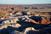 Petrified Forest National Park, Painted Desert
 -
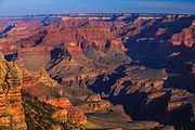 Grand Canyon National Park, South Rim
 -
 Zion National Park, Zion Canyon in autumn
 -

-

-
 Canyonlands National Park, Mesa Arch
 -
 Arches National Park, Landscape Arch
 -

-
 Mesa Verde National Park, Cliff Palace
 -
 Chaco Culture National Historical Park, Pueblo Bonito

.jpg)
.jpg)


See also
 Environment portal
 Geography portal
 Geology portal
 History portal
 United States portal
 Arizona portal
 Colorado portal
 New Mexico portal
 Utah portal
- Mojave Desert
- Great Basin
- Sonoran Desert
- Chihuahuan Desert
- Llano Estacado (a similar geographic region in Texas and New Mexico, cut by steep sided canyons such as Palo Duro Canyon)
References
- ^ "Colorado Plateau | plateau, United States". Encyclopædia Britannica. Retrieved 2017-06-05.
- ^ Leighty, Robert D. (2001). "Colorado Plateau Physiographic Province". Contract Report. Defense Advanced Research Projects Agency (DOD) Information Sciences Office. Archived from the original on 2004-09-26. Retrieved 2007-12-25.
- ^ ISBN 0-471-33218-6.
- ^ Moore, B.J. (1982). Analyses of natural gases, 1917–80. Vol. 8870. US Department of the Interior. pp. 4–5. Retrieved 30 October 2021.
- ^ Crampton, Gregory (1964). Standing Up Country. New York: Alfred Knopf. pp. 43–46.
- ^ a b c
 This article incorporates public domain material from "Colorado Plateau Province". Geologic Provinces of the United States. United States Geological Survey. Archived from the original on 2017-07-09. Retrieved 2017-07-04.
- S2CID 4322477.
- ^ "Why is the Colorado Plateau Rising?". Geology.com. Archived from the original on 2011-05-05. Retrieved 9 May 2011.
- ^ "Colorado Plateau shrublands". Terrestrial Ecoregions. World Wildlife Fund.
- ^ "Moab's steady progress through a decade of cleanup". Office of Environmental Management. U.S. Department of Energy. 12 September 2019. Retrieved 20 June 2022.
- ^ Kotkin, Joel (3 July 1978). "Coal-fired power plant apparently finds a home". The Washington Post. Retrieved 20 June 2022.
- ^ Utah: A Guide to the State. 1982. p. 590.
Further reading
- Baars, Donald L. (1972). Red Rock Country: The Geologic History of the Colorado Plateau. Doubleday. ISBN 0385013418.
- Baars, Donald L. (2002). Traveler's Guide to the Geology of the Colorado Plateau. University of Utah Press. ISBN 0874807158.
- Baldridge, W. Scott (2004). Geology of the American Southwest: A Journey Through Two Billion Years of Plate-Tectonic History. Cambridge University Press. ISBN 0521016665.
- Bauman, Joseph M. (1994), "The Colorado Plateau", Utah History Encyclopedia, University of Utah Press, ISBN 9780874804256, archived from the originalon March 21, 2024, retrieved April 12, 2024
- Fillmore, Robert (2011). Geological Evolution of the Colorado Plateau of Eastern Utah and Western Colorado. University of Utah Press. ISBN 978-1607810049.
- Harris, Ann G.; Tuttle, Esther; Tuttle, Sherwood D. (1997). Geology of National Parks (Fifth ed.). Iowa: Kendall/Hunt Publishing. pp. 2–3, 19–20, 25. ISBN 0787253537.
- Plummer, Charles C.; McGeary, David; Carlson, Diane H. (1999). Physical Geology (Eighth ed.). Boston: McGraw-Hill. p. 320. ISBN 0697374041.
- Stanley, Steven M. (1999). Earth System History. W.H. Freeman and Company. pp. 511–513, 537. ISBN 0716728826.
- Foos, Annabelle. Geology of the Colorado Plateau (PDF). National Park Service. Archived from the original (PDF) on 2004-06-10. Retrieved 2005-12-21.
- Roylance, Ward (1982). Utah: A Guide to the State. Salt Lake City: Utah: A Guide to the State Foundation. OL 3508093M.
- Look, Al (1947). A Thousand Million Years on the Colorado Plateau. Golden Bell Publications. OCLC 254673147.
- Trimble, Stephen (1979). The Bright Edge: A Guide to the National Parks of the Colorado Plateau. Museum of Northern Arizona Press. OCLC 768218015.
External links
Colorado River system | |||||||||
|---|---|---|---|---|---|---|---|---|---|
| Jurisdictions |
|     | |||||||
| Canyons |
| ||||||||
| Natural features |
| ||||||||
| Tributaries | |||||||||
| Engineering |
| ||||||||
| Designated areas | |||||||||
| Related topics | |||||||||