
Columbia River Gorge
| Columbia River Gorge | |
|---|---|
 Looking east up the Columbia River Gorge from near Multnomah Falls. | |
 | |
| Location | Pacific Northwest, United States |
| Established | 1986 |
| Website | www |
The Columbia River Gorge is a
A popular recreational destination, the gorge holds federally protected status as the Columbia River Gorge National Scenic Area and is managed by the Columbia River Gorge Commission and the U.S. Forest Service.
Description
The Columbia River,

The gorge transitions between temperate rainforest to dry grasslands in only 80 miles (130 km), hosting a dramatic change in scenery while driving along
Atmospheric pressure differentials east and west of the Cascades create a wind tunnel effect in the deep cut of the gorge, generating 35-mile-per-hour (56 km/h) winds that make it a popular windsurfing and kiteboarding location. It also creates the right conditions for snow and ice storms during the winter months which also draw very cold east winds toward the mouth of the gorge on the west end.
The gorge is a popular destination for
Trails and day use sites are maintained by the Forest Service and many Oregon and Washington state parks.
Geology
The Columbia River Gorge began forming as far back as the Miocene (roughly 17 to 12 million years ago), and continued to take shape through the Pleistocene (2 million to 700,000 years ago). During this period the Cascade Range was forming, which slowly moved the Columbia River's delta about 100 miles (160 km) north to its current location.[3]
Although the river slowly eroded the land over this period of time, the most drastic changes took place at the end of the

Ecology
The Columbia River Gorge is home to a number of plant species that are endemic or found mostly in the gorge and surrounding areas, including Heterotheca villosa, Lomatium columbianum, Lomatium klickitatense, Lomatium suksdorfii, Penstemon barrettiae, and Primula poetica.[5]
History

The gorge has supported human habitation for over 13,000 years. Evidence of the
The gorge has provided a transportation corridor for thousands of years. Native Americans would travel through the gorge to trade at Celilo Falls, both along the river and over Lolo Pass on the north side of Mount Hood. In 1805, the route was used by the Lewis and Clark Expedition to reach the Pacific.[6] Early European and American settlers subsequently established steamboat lines and railroads through the gorge. Today, the BNSF Railway runs freights along the Washington side of the river, while its rival, the Union Pacific Railroad, runs freights along the Oregon shore. Until 1997, Amtrak's Pioneer also used the Union Pacific tracks. The Portland segment of the Empire Builder uses the BNSF tracks that pass through the gorge.
The Columbia River Highway, built in the early 20th century, was the first major paved highway in the Pacific Northwest. Shipping was greatly simplified after Bonneville Dam and The Dalles Dam submerged the gorge's major rapids such as Celilo Falls, a major salmon fishing site for local Native Americans until the site's submergence in 1957.

In November 1986,
In fall 2017, the Eagle Creek Fire burned in the gorge for three months, consuming almost 50,000 acres (78 sq mi; 200 km2). It reached 100% containment on November 30, 2017, but was not yet completely out.[9]
Gallery
-
 Crown Point in the Columbia River Gorge, looking upstream from Chanticleer Point
 -
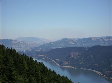
 Columbia River Gorge, photographed from the southern edge of the Gifford Pinchot National Forest
 -
 The view east towards The Dalles from Dog Mountain
 -
 Native American petroglyphs in the Columbia River Gorge near The Dalles Dam
 -
 Kitesurfingon the Columbia River
 -
 View of Columbia River Gorge from Cape Horn Trail, looking east toward Beacon Rock
 -
 Columbia River Gorge, photographed from Crown Point.
 -
 Triple Falls
 -
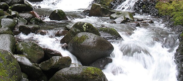 Oneonta Creek
 -
 Horsethief Butte, nearThe Dalles
 -
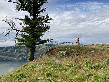 A couple overlooks the Columbia River Gorge from a viewpoint near Mosier, Oregon
 -
 A view of the Oregon side of the Columbia River Gorge from Hamilton Mountain
 -
 Columbia River Gorge with Mount Adams and Mount Saint Helens barely visible, seen from the Devils Rest Trail


See also
- Barlow Road, the first wagon-compatible pioneer road to provide a safer alternative to traveling through the gorge
- Cascades Rapids
- Proposed Columbia Gorge casino, a proposed off-reservation casino in Cascade Locks
- Wahclella Falls
- Nancy Neighbor Russell, conservationist and co-founder of Friends of the Columbia Gorge
References
- ^ Staats, David (November 21, 1983). "The Gorge". Spokane Chronicle. (Washington). Associated Press. p. A15.
- ^ "Columbia River Gorge of Oregon". Northwest Waterfall Survey. Retrieved February 6, 2011.
- ^ a b "Columbia River Gorge". Northwest Power and Conservation Council. 2021. Archived from the original on July 8, 2007. Retrieved June 2, 2008.
- ^ Dietrich, William (September 30, 2007). "Trailing An Apocalypse". The Seattle Times, Pacific Northwest Magazine. Retrieved October 23, 2021.
- ^ "iNaturalist". Retrieved January 6, 2023.
- S2CID 131976728. Archived from the originalon March 28, 2009.
- ^ Columbia River Gorge National Scenic Area Act Archived 2015-04-08 at the Wayback Machine from GorgeFriends.org
- ^ Geranios, Nicholas K. (June 3, 1990). "Columbia Gorge controversy smolders". The Seattle Times. Associated Press. p. B3.
- ^ Ryan, Jim (November 30, 2017). "Columbia Gorge fire declared 100 percent contained; hot spots still possible". The Oregonian. Retrieved December 5, 2017.
External links
- U.S. Forest Service - Columbia River Gorge National Scenic Area
- Columbia River Gorge Commission
- The Gorge Magazine
- Abbott, Carl. "Columbia Gorge National Scenic Area". The Oregon Encyclopedia.
- Portland State University Columbia River Gorge National Scenic Area Collection—contains research material used to write the book Planning a New West: The Columbia River Gorge National Scenic Area
- The River They Saw Documentary produced by Oregon Public Broadcasting
| Provinces and states traversed |  | |
|---|---|---|
| Lists | ||
| Geology and geography | ||
| Falls and rapids | ||
| History |
| |
| Ecology and culture |
| |
| Ice Age Glacial Floods |
|  |
|---|---|---|
| Glacial Lakes | ||
| Temporary Lakes | ||
| Ice Age Floods Glacial Residue | ||
| Ice Age Floods Erosion & Deposition Features | ||
| Related contemporaneous events |
| |
State of Washington | |||||||
|---|---|---|---|---|---|---|---|
Olympia (capital) | |||||||
| Topics |
| ||||||
| Society | |||||||
| Politics |
| ||||||
| Regions |
| ||||||
| Largest cities |
| ||||||
| Counties |
| ||||||