
Conquistador

_-_Autor_desconhecido.png)
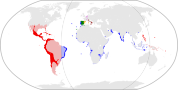
Conquistadors (/kɒnˈk(w)ɪstədɔːrz/, US also /-ˈkiːs-, kɒŋˈ-/) or conquistadores[1] (Spanish: [koŋkistaˈðoɾes], Portuguese: [kõkiʃtɐˈðoɾɨʃ, kõkistɐˈdoɾis]; lit 'conquerors') were the explorer-soldiers of the Spanish and Portuguese Empires of the 15th and 16th centuries.[2][3] During the Age of Discovery, conquistadors sailed beyond Europe to the Americas, Oceania, Africa, and Asia, colonizing and opening trade routes. They brought much of the new world under the dominion of Spain and Portugal.
After arrival in the
Spanish conquistadors also made significant explorations into the Amazon Jungle, Patagonia, the interior of North America, and the discovery and exploration of the Pacific Ocean. Conquistadors founded numerous cities, some of them in locations with pre-existing settlements, such as Cusco and Mexico City.
Conquistadors in the service of the Portuguese Crown led numerous conquests and visits in the name of the Portuguese Empire across South America and Africa, going "anticlockwise" along the continent's coast right up to the Red Sea, as well as commercial colonies in Asia, founding the origins of modern Portuguese-speaking world. Notable Portuguese conquistadors include Afonso de Albuquerque who led conquests across India, the Persian Gulf, the East Indies, and East Africa, and Filipe de Brito e Nicote who led conquests into Burma.
Conquest
.jpg)
_-_Autor_desconhecido.png)
Portugal established a route to China in the early 16th century, sending ships via the southern coast of Africa and founding numerous coastal enclaves along the route. Following the discovery in 1492 by Spaniards of the New World with Italian explorer Christopher Columbus' first voyage there and the first circumnavigation of the world by Ferdinand Magellan in 1521, expeditions led by conquistadors in the 16th century established trading routes linking Europe with all these areas.[5]
The Age of Discovery was hallmarked in 1519, shortly after the European discovery of the Americas, when Hernán Cortés began his conquest of the Aztec Empire.[6] As the Spaniards, motivated by gold and fame, established relations and war with the Aztecs, the slow progression of conquest, erection of towns, and cultural dominance over the natives brought more Spanish troops and support to modern-day Mexico. As trading routes over the seas were established by the works of Columbus, Magellan, and Elcano, land support system was established as the trails of Cortés' conquest to the capital.
Human infections gained worldwide transmission vectors for the first time: from Africa and Eurasia to the Americas and vice versa.[7][8][9] The spread of Old World diseases, including smallpox, influenza, and typhus, led to the deaths of many indigenous inhabitants of the New World.
In the 16th century, perhaps 240,000 Spaniards entered American ports.[10][11] By the late 16th century, gold and silver imports from the Americas provided one-fifth of Spain's total budget.[12]
Background

Contrary to popular belief, many conquistadors were not trained warriors, but mostly artisans, lesser nobility or farmers seeking an opportunity to advance themselves in the new world since they had limited opportunities in Spain.[13] A few also had crude firearms known as arquebuses. Their units (compañia) would often specialize in forms of combat that required long periods of training that were too costly for informal groups. Their armies were mostly composed of Spanish troops, as well as soldiers from other parts of Europe and Africa.
Native allied troops were largely infantry equipped with armament and armour that varied geographically. Some groups consisted of young men without military experience, Catholic clergy who helped with administrative duties, and soldiers with military training. These native forces often included African slaves and Native Americans, some of whom were also slaves. They were not only made to fight in the battlefield but also to serve as interpreters, informants, servants, teachers, physicians, and scribes. India Catalina and Malintzin were Native American women slaves who were forced to work for the Spaniards.[citation needed]
Castilian law prohibited foreigners and non-Catholics from settling in the New World. However, not all conquistadors were Castilian. Many foreigners
The origin of many people in mixed expeditions was not always distinguished. Various occupations, such as sailors, fishermen, soldiers and nobles employed different languages (even from unrelated language groups), so that crew and settlers of Iberian empires recorded as Galicians from Spain were actually using Portuguese, Basque, Catalan, Italian and Languedoc languages, which were wrongly identified.
Castilian law banned Spanish women from travelling to America unless they were married and accompanied by a husband. Women who travelled thus include María de Escobar,

European young men enlisted in the army because it was one way out of poverty. Catholic priests instructed the soldiers in mathematics, writing, theology, Latin, Greek, and history, and wrote letters and official documents for them. King's army officers taught military arts. An uneducated young recruit could become a military leader, elected by their fellow professional soldiers, perhaps based on merit. Others were born into hidalgo families, and as such they were members of the Spanish nobility with some studies but without economic resources. Even some rich nobility families' members became soldiers or missionaries, but mostly not the firstborn heirs.
The two most famous conquistadors were Hernán Cortés who conquered the Aztec Empire and Francisco Pizarro who led the conquest of the Inca Empire. They were second cousins born in Extremadura, where many of the Spanish conquerors were born.
Catholic religious orders that participated and supported the exploration, evangelizing and pacifying, were mostly
The conquistadors took many different roles, including religious leader,

After Mexico fell, Hernán Cortés's enemies
The division of the booty produced bloody conflicts, such as the one between Pizarro and De Almagro. After present-day Peruvian territories fell to Spain,
The Emperor commissioned bishop
History


Early Portuguese period
Throughout the 15th century,
Birth of the Spanish Kingdom
After his father's death in 1479,
The Iberian Peninsula was largely divided before the hallmark of this marriage. Five independent kingdoms: Portugal in the West, Aragon and Navarre in the East, Castile in the large center, and Granada in the south, all had independent sovereignty and competing interests. The conflict between Christians and Muslims to control Iberia, which started with North Africa's Muslim invasion in 711, lasted from the years 718 to 1492.[6] Christians, fighting for control, successfully pushed the Muslims back to Granada, which was the Muslims' last control of the Iberian Peninsula.
The marriage between Ferdinand of Aragon and Isabel of Castile resulted in joint rule by the spouses of the two kingdoms, honoured as the "Catholic Monarchs" by Pope Alexander VI.[6] Together, the Crown Kings saw about the fall of Granada, victory over the Muslim minority, and expulsion or forcibly converted Jews and non-Christians to turn Iberia into a religious homogeneity.
Treaties
The 1492 discovery of the
The known means of measuring longitude were so inexact that the line of demarcation could not in practice be determined,[15] subjecting the treaty to diverse interpretations. Both the Portuguese claim to Brazil and the Spanish claim to the Moluccas depended on the treaty. It was particularly valuable to the Portuguese as a recognition of their new-found,[clarification needed] particularly when, in 1497–1499, Vasco da Gama completed the voyage to India.
Later, when Spain established a route to the Indies from the west, Portugal arranged a second treaty, the Treaty of Zaragoza.
Spanish exploration
Colonization of the Caribbean, Mesoamerica, and South America

After first landing on "Guanahani" in the Bahamas, Columbus found the island which he called "Isla Juana", later named Cuba.[18] In 1511, the first Adelantado of Cuba, Diego Velázquez de Cuéllar founded the island's first Spanish settlement at Baracoa; other towns soon followed, including Havana, which was founded in 1515.
After he pacified

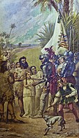
Hernán Cortés, led an expedition (entrada) to Mexico, which included Pedro de Alvarado and Bernardino Vázquez de Tapia. The Spanish campaign against the Aztec Empire had its final victory on 13 August 1521, when a coalition army of Spanish forces and native Tlaxcalan warriors led by Cortés and Xicotencatl the Younger captured the emperor Cuauhtemoc and Tenochtitlan, the capital of the Aztec Empire. The fall of Tenochtitlan marks the beginning of Spanish rule in central Mexico, and they established their capital of Mexico City on the ruins of Tenochtitlan. The Spanish conquest of the Aztec Empire was one of the most significant events in world history.
In 1516,
In 1517,
The expedition returned to Cuba to report on the discovery of this new land.After receiving notice from

Dávila sent

Dávila made an agreement with Francisco Pizarro and Diego de Almagro, which brought about the discovery of Peru, but withdrew in 1526 for a small compensation, having lost confidence in the outcome. In 1526 Dávila was superseded as Governor of Panama by Pedro de los Ríos, but became governor in 1527 of León in Nicaragua.
An expedition commanded by Pizarro and his brothers explored south from what is today Panama, reaching Inca territory by 1526.[23] After one more expedition in 1529, Pizarro received royal approval to conquer the region and be its viceroy. The approval read: "In July 1529 the queen of Spain signed a charter allowing Pizarro to conquer the Inca. Pizarro was named governor and captain of all conquests in New Castile."[24] The Viceroyalty of Peru was established in 1542, encompassing all Spanish holdings in South America.

In early 1536, the Adelantado of

Juan Díaz de Solís arrived again to the renamed Río de la Plata, literally river of the silver, after the Incan conquest. He sought a way to transport the Potosi's silver to Europe. For a long time due to the Incan silver mines, Potosí was the most important site in Colonial Spanish America, located in the current department of Potosí in Bolivia[25] and it was the location of the Spanish colonial mint. The first settlement in the way was the fort of Sancti Spiritu, established in 1527 next to the Paraná River. Buenos Aires was established in 1536, establishing the Governorate of the Río de la Plata.[26]

Africans were also conquistadors in the early conquest campaigns in the Caribbean and Mexico. In the 1500s there were enslaved black and free black[clarification needed] sailors on Spanish ships crossing the Atlantic and developing new routes of conquest and trade in the Americas.[27] After 1521, the wealth and credit generated by the acquisition of the Aztec Empire funded auxiliary forces of black conquistadors that could number as many as five hundred. Spaniards recognized the value of these fighters. [citation needed]
One of the black conquistadors who fought against the Aztecs and survived the destruction of their empire was Juan Garrido. Born in Africa, Garrido lived as a young slave in Portugal before being sold to a Spaniard and acquiring his freedom fighting in the conquests of Puerto Rico, Cuba, and other islands. He fought as a free servant or auxiliary, participating in Spanish expeditions to other parts of Mexico (including Baja California) in the 1520s and 1530s. Granted a house plot in Mexico City, he raised a family there, working at times as a guard and town crier. He claimed to have been the first person to plant wheat in Mexico.[28]

Sebastian Toral was an African slave and one of the first black conquistadors in the New World. While a slave, he went with his Spanish owner on a campaign. He was able to earn his freedom during this service. He continued as a free conquistador with the Spaniards to fight the Maya in Yucatán in 1540. After the conquests he settled in the city of Mérida in the newly formed colony of Yucatán with his family. In 1574, the Spanish crown ordered that all slaves and free blacks in the colony had to pay a tribute to the crown. However, Toral wrote in protest of the tax based on his services during his conquests. The Spanish king responded that Toral need not pay the tax because of his service. Toral died a veteran of three transatlantic voyages and two Conquest expeditions, a man who had successfully petitioned the great Spanish King, walked the streets of Lisbon, Seville, and Mexico City, and helped found a capital city in the Americas.[29]
Juan Valiente was born West Africa and purchased by Portuguese traders from African slavers. Around 1530 he was purchased by Alonso Valiente to be a slaved domestic servant in Puebla, Mexico. In 1533, Juan Valiente made a deal with his owner to allow him to be a conquistador for four years with the agreement that all earnings would come back to Alonso. He fought for many years in Chile and Peru. By 1540, he was a captain, horseman, and partner in Pedro de Valdivia's company in Chile. He was later awarded an estate in Santiago; a city he would help Valdivia found. Both Alonso and Valiente tried to contact the other to make an agreement about Valiente's manumission and send Alonso his awarded money. They were never able to reach each other and Valiente died in 1553 in the Battle of Tucapel.[30]
Other black conquistadors include Pedro Fulupo, Juan Bardales, Antonio Pérez, and Juan Portugués. Pedro Fulupo was a black slave that fought in Costa Rica. Juan Bardales was an African slave that fought in Honduras and Panama. For his service he was granted manumission and a pension of 50 pesos. Antonio Pérez was from North Africa, and a free black. He joined the conquest in Venezuela and was made a captain. Juan Portugués fought in the conquests in Venezuela.[30]
North America colonization

During the 1500s, the Spanish began to travel through and colonize North America. They were looking for gold in foreign kingdoms. By 1511 there were rumours of undiscovered lands to the northwest of Hispaniola. Juan Ponce de León equipped three ships with at least 200 men at his own expense and set out from Puerto Rico on 4 March 1513 to Florida and surrounding coastal area. Another early motive was the search for the Seven Cities of Gold, or "Cibola", rumoured to have been built by Native Americans somewhere in the desert Southwest. In 1536 Francisco de Ulloa, the first documented European to reach the Colorado River, sailed up the Gulf of California and a short distance into the river's delta.[31]
The
In 1524, the Portuguese
The Spaniard

Later they were enslaved for a few years by various Native American tribes of the upper

The viceroy of New Spain Antonio de Mendoza, for whom is named the Codex Mendoza, commissioned several expeditions to explore and establish settlements in the northern lands of New Spain in 1540–1542. Francisco Vázquez de Coronado reached Quivira in central Kansas. Juan Rodríguez Cabrillo explored the western coastline of Alta California in 1542–1543. Vázquez de Coronado's 1540–1542 expedition began as a search for the fabled Cities of Gold, but after learning from natives in New Mexico of a large river to the west, he sent García López de Cárdenas to lead a small contingent to find it. With the guidance of Hopi Indians, Cárdenas and his men became the first outsiders to see the Grand Canyon.[38] However, Cárdenas was reportedly unimpressed with the canyon, assuming the width of the Colorado River at six feet (1.8 m) and estimating 300-foot-tall (91 m) rock formations to be the size of a person. After unsuccessfully attempting to descend to the river, they left the area, defeated by the difficult terrain and torrid weather.[39]
In 1540,

In 1540, expeditions under Hernando de Alarcon and Melchior Diaz visited the area of
The marriage between Luisa de Abrego, a free black domestic servant from Seville and Miguel Rodríguez, a white Segovian conquistador in 1565 in St. Augustine (Spanish Florida), is the first known and recorded Christian marriage anywhere in the continental United States.[40]
The Chamuscado and Rodríguez Expedition explored New Mexico in 1581–1582. They explored a part of the route visited by Coronado in New Mexico and other parts in the southwestern United States between 1540 and 1542.
The viceroy of New Spain Don Diego García Sarmiento sent another expedition in 1648 to explore, conquer and colonize the Californias.
Asia and Oceania colonization, and Pacific exploration
In 1525,

In 1564,

The Spanish settled and took control of Tidore in 1603 to trade spices and counter Dutch encroachment in the archipelago of Maluku. The Spanish presence lasted until 1663, when the settlers and military were moved back to the Philippines. Part of the Ternatean population chose to leave with the Spanish, settling near Manila in what later became the municipality of Ternate. Spanish galleons traveled across the Pacific Ocean between Acapulco in Mexico and Manila.

In 1542, Juan Rodríguez Cabrillo traversed the coast of California and named many of its features. In 1601, Sebastián Vizcaíno mapped the coastline in detail and gave new names to many features. Martín de Aguilar, lost from the expedition led by Sebastián Vizcaíno, explored the Pacific coast as far north as Coos Bay in present-day Oregon.[41]
Since the 1549 arrival to Kagoshima (Kyushu) of a group of Jesuits with St. Francis Xavier missionary and Portuguese traders, Spain was interested in Japan. In this first group of Jesuit missionaries were included Spaniards Cosme de Torres and Juan Fernandez.
In 1611, Sebastián Vizcaíno surveyed the east coast of Japan and from the year of 1611 to 1614 he was ambassador of King Felipe III in Japan returning to Acapulco in the year of 1614.[citation needed] In 1608, he was sent to search for two mythical islands called Rico de Oro (island of gold) and Rico de Plata (island of silver).[42]
Portuguese exploration


As a seafaring people in the south-westernmost region of Europe, the Portuguese became natural leaders of exploration during the Middle Ages. Faced with the options of either accessing other European markets by sea, by exploiting its seafaring prowess, or by land, and facing the task of crossing
One important reason was the need for alternatives to the expensive eastern trade routes that followed the Silk Road. Those routes were dominated first by the republics of Venice and Genoa, and then by the Ottoman Empire after the conquest of Constantinople in 1453. The Ottomans barred European access. For decades the Spanish Netherlands ports produced more revenue than the colonies since all goods brought from Spain, Mediterranean possessions, and the colonies were sold directly there to neighbouring European countries: wheat, olive oil, wine, silver, spice, wool and silk were big businesses.[citation needed]
The gold brought home from Guinea stimulated the commercial energy of the Portuguese, and its European neighbours, especially Spain. Apart from their religious and scientific aspects, these voyages of discovery were highly profitable.
They had benefited from Guinea's connections with neighbouring Iberians and north African Muslim states. Due to these connections, mathematicians and experts in naval technology appeared in Portugal. Portuguese and foreign experts made several breakthroughs in the fields of mathematics, cartography and naval technology.
Under Afonso V (1443–1481), surnamed the African, the Gulf of Guinea was explored as far as Cape St. Catherine (Cabo Santa Caterina),[44][45][46] and three expeditions in 1458, 1461 and 1471, were sent to Morocco; in 1471 Arzila (Asila) and Tangier were captured from the Moors. Portuguese explored the Atlantic, Indian and Pacific Oceans before the Iberian Union period (1580–1640). Under John II (1481–1495) the fortress of São Jorge da Mina, the modern Elmina, was founded for the protection of the Guinea trade. Diogo Cão, or Can, discovered the Congo in 1482 and reached Cape Cross in 1486.
In 1483, Diogo Cão sailed up the uncharted
On 7 May 1487, two Portuguese envoys,

In 1498,
Álvaro Caminha, in Cape Verde islands, who received the land as a grant from the crown, established a colony with Jews forced to stay on São Tomé Island. Príncipe island was settled in 1500 under a similar arrangement. Attracting settlers proved difficult; however, the Jewish settlement was a success and their descendants settled many parts of Brazil.[54]


From their peaceful settlings in secured islands along Atlantic Ocean (archipelagos and islands such as Madeira, the Azores, Cape Verde, São Tomé, Príncipe, and Annobón) they travelled to coastal enclaves trading almost every goods of African and Islander areas like spices (hemp, opium, garlic), wine, dry fish, dried meat, toasted flour, leather, fur of tropical animals and seals, whaling ... but mainly ivory, black slaves, gold and hardwoods. They maintaining trade ports in Congo (M'banza), Angola, Natal (City of Cape Good Hope, in Portuguese "Cidade do Cabo da Boa Esperança"), Mozambique (Sofala), Tanzania (Kilwa Kisiwani), Kenya (Malindi) to Somalia. The Portuguese following the maritime trade routes of Muslims and Chinese traders, sailed the Indian Ocean. They were on Malabar Coast since 1498 when Vasco da Gama reached Anjadir, Kannut, Kochi and Calicut.
Da Gama in 1498 marked the beginning of Portuguese influence in Indian Ocean. In 1503 or 1504, Zanzibar became part of the Portuguese Empire when Captain Ruy Lourenço Ravasco Marques landed and demanded and received tribute from the sultan in exchange for peace.[55]: page: 99 Zanzibar remained a possession of Portugal for almost two centuries. It initially became part of the Portuguese province of Arabia and Ethiopia and was administered by a governor general. Around 1571, Zanzibar became part of the western division of the Portuguese empire and was administered from Mozambique.[56]: 15 It appears, however, that the Portuguese did not closely administer Zanzibar. The first English ship to visit Unguja, the Edward Bonaventure in 1591, found that there was no Portuguese fort or garrison. The extent of their occupation was a trade depot where produce was purchased and collected for shipment to Mozambique. "In other respects, the affairs of the island were managed by the local 'king,' the predecessor of the Mwinyi Mkuu of Dunga."[57]: 81 This hands-off approach ended when Portugal established a fort on Pemba around 1635 in response to the Sultan of Mombasa's slaughter of Portuguese residents several years earlier.
After 1500: West and East Africa, Asia, and the Pacific
In west Africa Cidade de Congo de São Salvador was founded some time after the arrival of the Portuguese, in the pre-existing capital of the local dynasty ruling at that time (1483), in a city of the Luezi River valley. Portuguese were established supporting one Christian local dynasty ruling suitor.
When
The aggregate of Portugal's colonial holdings in India were
More envoys were sent in 1507 to Ethiopia, after
In 1509, the Portuguese under Francisco de Almeida won a critical victory in the

To enforce a trade monopoly,
In 1511, the Portuguese were the first Europeans to reach the city of Guangzhou by the sea, and they settled on its port for a commercial monopoly of trade with other nations. They were later expelled from their settlements, but they were allowed the use of Macau, which was also occupied in 1511, and to be appointed in 1557 as the base for doing business with Guangzhou. The quasi-monopoly on foreign trade in the region would be maintained by the Portuguese until the early seventeenth century, when the Spanish and Dutch arrived.
The Portuguese
Allying himself with Ternate's ruler, Serrão constructed a fortress on that tiny island and served as the head of a

The Portuguese first landed in Ambon in 1513, but it only became the new centre for their activities in Maluku following the expulsion from Ternate. European power in the region was weak and Ternate became an expanding, fiercely Islamic and anti-European state under the rule of Sultan Baab Ullah (r. 1570–1583) and his son Sultan Said.[75] The Portuguese in Ambon, however, were regularly attacked by native Muslims on the island's northern coast, in particular Hitu which had trading and religious links with major port cities on Java's north coast. Altogether, the Portuguese never had the resources or manpower to control the local trade in spices, and failed in attempts to establish their authority over the crucial Banda Islands, the nearby centre of most nutmeg and mace production. Following Portuguese missionary work, there have been large Christian communities in eastern Indonesia particularly among the Ambonese.[75] By the 1560s there were 10,000 Catholics in the area, mostly on Ambon, and by the 1590s there were 50,000 to 60,000, although most of the region surrounding Ambon remained Muslim.[75]
North America

Based on the Treaty of Tordesillas, Manuel I claimed territorial rights in the area visited by John Cabot in 1497 and 1498.[76] To that end, in 1499 and 1500, the Portuguese mariner João Fernandes Lavrador visited the northeast Atlantic coast and Greenland and the north Atlantic coast of Canada, which accounts for the appearance of "Labrador" on topographical maps of the period.[77] Subsequently, in 1501 and 1502 the Corte-Real brothers explored and charted Greenland and the coasts of present-day Newfoundland and Labrador, claiming these lands as part of the Portuguese Empire. Whether or not the Corte-Reals expeditions were also inspired by or continuing the alleged voyages of their father, João Vaz Corte-Real (with other Europeans) in 1473, to Terra Nova do Bacalhau (Newfoundland of the Codfish), remains controversial, as the 16th century accounts of the 1473 expedition differ considerably. In 1520–1521, João Álvares Fagundes was granted donatary rights to the inner islands of the Gulf of St. Lawrence. Accompanied by colonists from mainland Portugal and the Azores, he explored Newfoundland and Nova Scotia (possibly reaching the Bay of Fundy on the Minas Basin[78]), and established a fishing colony on Cape Breton Island, that would last some years or until at least 1570s, based on contemporary accounts.[79]
South America

Brazil was claimed by Portugal in April 1500, on the arrival of the Portuguese fleet commanded by Pedro Álvares Cabral.[80] The Portuguese encountered natives divided into several tribes. The first settlement was founded in 1532. Some European countries, especially France, were also sending excursions to Brazil to extract
.The Portuguese frequently relied on the help of
The Portuguese assimilated some of the native tribes[84] while others were enslaved or exterminated in long wars or by European diseases to which they had no immunity.[85][86] By the mid-16th century, sugar had become Brazil's most important export[87][88] and the Portuguese imported African slaves[89][90] to produce it.


The Dutch sacked
In the 1620s and 1630s, the
In 1624 most of the inhabitants of the town Pernambuco (Recife), in the future Dutch colony of Brazil were Sephardic Jews who had been banned by the Portuguese Inquisition to this town at the other side of the Atlantic Ocean. As some years afterward the Dutch in Brazil appealed to Holland for craftsmen of all kinds, many Jews went to Brazil; about 600 Jews left Amsterdam in 1642, accompanied by two distinguished scholars – Isaac Aboab da Fonseca and Moses Raphael de Aguilar. In the struggle between Holland and Portugal for the possession of Brazil the Dutch were supported by the Jews.
From 1630 to 1654, the Dutch set up more permanently in the Nordeste and controlled a long stretch of the coast most accessible to Europe, without, however, penetrating the interior. But the colonists of the
Portuguese sent military expeditions to the
In the 1690s, gold was discovered by explorers in the region that would later be called Minas Gerais (General Mines) in current Mato Grosso and Goiás.
Before the Iberian Union period (1580–1640), Spain tried to prevent Portuguese expansion into Brazil with the 1494 Treaty of Tordesillas. After the Iberian Union period, the Eastern Strip were settled by Portugal. This was disputed in vain, and in 1777 Spain confirmed Portuguese sovereignty.
Iberian Union period (1580–1640)

In 1578, the Saadi

As a result of the Iberian Union, Phillip II's enemies became Portugal's enemies, such as the Dutch in the Dutch–Portuguese War, England or France. The English-Spanish wars of 1585–1604 were clashes not only in English and Spanish ports or on the sea between them but also in and around the present-day territories of Florida, Puerto Rico, the Dominican Republic, Ecuador, and Panama. War with the Dutch led to invasions of many countries in Asia, including Ceylon and commercial interests in Japan, Africa (Mina), and South America. Even though the Portuguese were unable to capture the entire island of Ceylon, they were able to control its coastal regions for a considerable time.
From 1580 to 1670 mostly, the

In the 17th century, taking advantage of this period of Portuguese weakness, the Dutch occupied many Portuguese territories in Brazil. John Maurice, Prince of Nassau-Siegen was appointed as the governor of the Dutch possessions in Brazil in 1637 by the Dutch West India Company. He landed at Recife, the port of Pernambuco, in January 1637. In a series of expeditions, he gradually expanded from Sergipe on the south to São Luís de Maranhão in the north. He likewise conquered the Portuguese possessions of Elmina Castle, Saint Thomas, and Luanda and Angola. The Dutch intrusion into Brazil was long lasting and troublesome to Portugal. The Seventeen Provinces captured a large portion of the Brazilian coast including the provinces of Bahia, Pernambuco, Paraíba, Rio Grande do Norte, Ceará, and Sergipe, while Dutch privateers sacked Portuguese ships in both the Atlantic and Indian Oceans. The large area of Bahia and its city, the strategically important Salvador, was recovered quickly by an Iberian military expedition in 1625.
After the dissolution of the Iberian Union in 1640, Portugal re-established authority over its lost territories including remaining Dutch controlled areas. The other smaller, less developed areas were recovered in stages and relieved of Dutch piracy in the next two decades by local resistance and Portuguese expeditions.
Spanish Formosa was established in Taiwan, first by Portugal in 1544 and later renamed and repositioned by Spain in Keelung. It became a natural defence site for the Iberian Union. The colony was designed to protect Spanish and Portuguese trade from interference by the Dutch base in the south of Taiwan. The Spanish colony was short-lived due to the unwillingness of Spanish colonial authorities in Manila to defend it.
Disease in the Americas

While technological superiority, military strategy and forging local alliances played an important role in the victories of the conquistadors in the Americas, their conquest was greatly facilitated by Old World diseases:
When
Recently developed
The American researcher H.F. Dobyns said that 95% of the total population of the Americas died in the first 130 years,[103] and that 90% of the population of the Inca Empire died in epidemics.[104] Cook and Borah of the University of California at Berkeley believe that the indigenous population in Mexico declined from 25.2 million in 1518 to 700,000 people in 1623, less than 3% of the original population.[105]
Mythic lands
The conquistadors found new animal species, but reports confused these with monsters such as giants, dragons, or ghosts.[106] Stories about castaways on mysterious islands were common.
An early motive for exploration was the search for Cipango, the place where gold was born. Cathay and Cibao were later goals. The Seven Cities of Gold, or "Cibola", was rumoured to have been built by Native Americans somewhere in the desert Southwest.[107][108] As early as 1611, Sebastián Vizcaíno surveyed the east coast of Japan and searched for two mythical islands called Rico de Oro ('Rich in Gold') and Rico de Plata ('Rich in Silver').

Books such as
Sir Walter Raleigh and some Italian, Spanish, Dutch, French and Portuguese expeditions were looking for the wonderful Guiana empire that gave its name to the present day countries of the Guianas.
Several expeditions went in search of these fabulous places, but returned empty-handed, or brought less gold than they had hoped. They found other
Shipwrecked off
Secrecy

The Spanish discovery of what they thought at that time was India, and the constant competition of Portugal and Spain led to a desire for secrecy about every trade route and every colony. As a consequence, many documents that could reach other European countries included fake dates and faked facts, to mislead any other nation's possible efforts. For example, the Island of California refers to a famous cartographic error propagated on many maps during the 17th and 18th centuries, despite contradictory evidence from various explorers. The legend was initially infused with the idea that California was a terrestrial paradise, peopled by black Amazons.
The tendency to secrecy and falsification of dates casts doubts about the authenticity of many
Financing and governance

Ferdinand II King of Aragon and Regent of Castile, incorporated the American territories into the Kingdom of Castile and then withdrew the authority granted to governor Christopher Columbus and the first conquistadors. He established direct royal control with the Council of the Indies, the most important administrative organ of the Spanish Empire, both in the Americas and in Asia. After unifying Castile, Ferdinand introduced to Castile many laws, regulations and institutions such as the Inquisition, that were typical in Aragon. These laws were later used in the new lands.
The Laws of Burgos, created in 1512–1513, were the first codified set of laws governing the behavior of settlers in Spanish colonial America, particularly with regards to Native Americans. They forbade the maltreatment of indigenous people, and endorsed their conversion to Catholicism.
The evolving structure of colonial government was not fully formed until the third quarter of the 16th century; however,

The Crown reserved for itself important tools of intervention. The "capitulacion" clearly stated that the conquered territories belonged to the Crown, not to the individual. On the other hand, concessions allowed the Crown to guide the Companies conquests to certain territories, depending on their interests. In addition, the leader of the expedition received clear instructions about their duties towards the army, the native population, the type of military action. A written report about the results was mandatory. The army had a royal official, the "veedor". The "veedor" or notary, ensured they complied with orders and instructions and preserved the King's share of the booty.
In practice the Capitán had almost unlimited power. Besides the Crown and the conquistador, they were very important the backers who were charged with anticipating the money to the Capitán and guarantee payment of obligations.
Armed groups sought supplies and funds in various ways. Financing was requested from the King, delegates of the Crown, the nobility, rich merchants or the troops themselves. The more professional campaigns were funded by the Crown. Campaigns were sometimes initiated by inexperienced governors, because in Spanish Colonial America, offices were bought or handed to relatives or cronies. Sometimes, an expedition of conquistadors were a group of influential men who had recruited and equipped their fighters, by promising a share of the booty.
Aside from the explorations predominated by Spain and Portugal, other parts of Europe also aided in colonization of the New World. King Charles I was documented to receive loans from the German Welser family to help finance the Venezuela expedition for gold.[6] With numerous armed groups aiming to launch explorations well into the Age of Conquest, the Crown became indebted, allowing opportunity for foreign European creditors to finance the explorations.
The conquistador borrowed as little as possible, preferring to invest all their belongings. Sometimes, every soldier brought his own equipment and supplies, other times the soldiers received gear as an advance from the conquistador.
The
Sponsors included governments, the king, viceroys, and local governors backed by rich men. The contribution of each individual conditioned the subsequent division of the booty, receiving a portion the pawn (lancero, piquero, alabardero, rodelero) and twice a man on horseback (caballero) owner of a horse.[clarification needed] Sometimes part of the booty consisted of women and/or slaves. Even the dogs, important weapons of war in their own right, were in some cases rewarded. The division of the booty produced conflicts, such as the one between Pizarro and Almagro.
Military advantages

_01.jpg)
Though vastly outnumbered on foreign and unknown territory, Conquistadors had several military advantages over the native peoples they conquered, military strategies and tactics that were mostly learned from the 781 year war of the Reconquista.

Strategy
One factor was the ability of the conquistadors to manipulate the political situation between indigenous peoples and make alliances against larger empires. To beat the
Tactics
Spanish and Portuguese forces were capable of quickly moving long distances in foreign land, allowing for speed of maneuver to catch outnumbering forces by surprise. Wars were mainly between clans, expelling intruders. On land, these wars combined some European methods with techniques from Muslim bandits in Al-Andalus. These tactics consisted of small groups who attempted to catch their opponents by surprise, through an ambush.
In Mombasa, Vasco da Gama resorted to attacking Arab merchant ships, which were generally unarmed trading vessels without heavy cannons.
Weapons and animals
Weapons

Spanish conquistadors in the Americas made extensive use of swords, pikes, and crossbows, with arquebuses becoming widespread only from the 1570s.[115] A scarcity of firearms did not prevent conquistadors to pioneer the use of mounted arquebusiers, an early form of dragoon.[115] In the 1540s Francisco de Carvajal's use of firearms in the Spanish civil war in Peru prefigured the volley fire technique that developed in Europe many decades after.[115]
Animals


Animals were another important factor for Spanish triumph. On the one hand, the introduction of the horse and other domesticated pack animals allowed them greater mobility unknown to the Indian cultures. However, in the mountains and jungles, the Spaniards were less able to use narrow Amerindian roads and bridges made for pedestrian traffic, which were sometimes no wider than a few feet. In places such as
The Spaniards were also skilled at breeding dogs for war, hunting and protection. The
The most famous of these dogs of war was a mascot of Ponce de Leon called Becerrillo, the first European dog known to reach North America;[citation needed] another famous dog called Leoncico, the son of Becerillo, and the first European dog known to see the Pacific Ocean, was a mascot of Vasco Núñez de Balboa and accompanied him on several expeditions.
Nautical science

The successive expeditions and experience of the Spanish and Portuguese pilots led to a rapid evolution of European nautical science.
In the thirteenth century they were guided by the sun position. For
Ship design

The ship that truly launched the first phase of the discoveries along the African coast was the Portuguese caravel. Iberians quickly adopted it for their merchant navy. It was a development based on African fishing boats. They were agile and easier to navigate, with a tonnage of 50 to 160 tons and one to three masts, with lateen triangular sails allowing luffing. The caravel particularly benefited from a greater capacity to tack. The limited capacity for cargo and crew were their main drawbacks, but have not hindered its success. Limited crew and cargo space was acceptable, initially, because as exploratory ships, their "cargo" was what was in the explorer's discoveries about a new territory, which only took up the space of one person.[118] Among the famous caravels are Berrio and Caravela Annunciation. Columbus also used them in his travels.
Long oceanic voyages led to larger ships. "Nau" was the Portuguese archaic synonym for any large ship, primarily
Winds and currents

Besides coastal exploration, Portuguese ships also made trips further out to gather
The knowledge of wind patterns and
Cartography


In 1339
Mestre Jacome was a Majorcan cartographer induced by Portuguese prince
It is thought that
With his son, cartographer Jorge Reinel and Lopo Homem, they participated in the making of the atlas known as "Lopo Homem-Reinés Atlas" or "Miller Atlas", in 1519. They were considered the best cartographers of their time. Emperor Charles V wanted them to work for him. In 1517 King Manuel I of Portugal handed Lopo Homem a charter giving him the privilege to certify and amend all compass needles in vessels.[citation needed]
The third phase of nautical cartography was characterized by the abandonment of Ptolemy's representation of the East and more accuracy in the representation of lands and continents. Fernão Vaz Dourado (Goa ≈1520 – ≈1580), produced work of extraordinary quality and beauty, giving him a reputation as one of the best cartographers of the time. Many of his charts are large scale.[citation needed]
-
 Iberian Union (1581–1640)
 -
 The Magellan–Elcano voyage. The first travel around the world.
 -
 The Manila-Acapulco trade route started in 1568 and Spanish treasure fleets (white) and its eastwards rivals, the Portuguese India Armadas routes of 1498–1640 (blue)


People
-
 Inés Suárez was a Spanish conquistadora, successfully defending Santiago against a Mapuche attack in 1541
 -
 Gonzalo Guerrero, a shipwrecked Spanish mariner who married a Maya woman and later fought with the Mayas against the conquistadors
 -
 Conquest of the Canary Islands (1402–1496)
 -
 Bandeirantes were crucial in Portuguese exploration, colonization, and pacification of the Brazilian interior.


People in the service of Spain
- Cristopher Columbus (West Indies, 1492–1504)
- Alonso Fernández de Lugo (Canary Islands, 1492–1496)
- Hernán Cortés (Mexico, 1518–1522, Baja California, 1532–1536)
- Pedro de Alvarado (Mexico, 1519–1521, Guatemala, El Salvador 1523–1527, Peru, 1533–1535, Mexico, 1540–1541)
- Francisco Pizarro (Perú, 1509–1535)
- Gonzalo Jiménez de Quesada (Colombia, 1536–1539, Venezuela, 1569–1572)
- Pedro Fernández de Lugo (Canary Island, Colombia 1509–1536)
- Pedro de Candia (Panama, 1527, Colombia and Ecuador, 1528, Peru, 1530)
- Francisco Vásquez de Coronado(United States, 1540–1542)
- New Mexico, United States, 1598–1608)
- Juan Roque (Zape Confraternity)
- Juan Vásquez de Coronado y Anaya (Costa Rica)
- Diego de Almagro (Perú, 1524–1535, Chile, 1535–1537)
- Panamá, 1500–1527)
- Vasco Núñez de Balboa (Panamá, 1510–1519)
- Juan Ponce de León (Puerto Rico, 1508, Florida, 1513–1521)
- Álvar Núñez Cabeza de Vaca (United States, 1527–1536, 1540–1542)
- Lucas Vázquez de Ayllón (United States, 1524–1527)
- Sebastián de Belalcázar (Ecuador and Colombia, 1533–1536)
- Jerónimo Luis de Cabrera (Peru, Argentina, 16th century)
- Domingo Martínez de Irala (Argentina and Paraguay, 1535–1556)
- Gonzalo Pizarro (Perú, 1532–1542)
- Diego Velázquez de Cuéllar (Cuba, 1511–1519)
- Juan de Garay (Peru, Paraguay, Argentina, 16th century)
- Diego de Ordaz (Venezuela, 1532)
- Juan Pizarro (Perú, 1532–1536)
- Yucatán, 1517)
- Francisco Hernández de Córdoba (Nicaragua, 1524)
- Hernando Pizarro (Perú, 1532–1560)
- Sebastián Caboto (Uruguay 16th century)
- Jerónimo de Alderete (Perú, 1535–1540; Chile, 1550–1552)
- Diego Hernández de Serpa (Venezuela, 1510–1570)
- Juan de Grijalva (Yucatán, 1518)
- Francisco de Montejo (Yucatán, 1527–1546)
- Juan de la Cámara (Yucatán, 1539–1546)
- Nicolás Federmann (Venezuela and Colombia, 1537–1539).
- Pánfilo de Narváez (Spanish Florida, 1527–1528)
- Diego de Nicuesa (Panama, 1506–1511)
- Hernán Venegas Carrillo (Colombia, 1536–1544)
- Cristóbal de Olid (Honduras, 1523–1524)
- Francisco de Orellana (Amazon River, 1541–1543)
- Hernando de Soto (United States, 1539–1542)
- Gonzalo García Zorro (Colombia, 1536–1544)
- Inés Suárez, (Chile, 1541)
- Francisco de Aguirre, Peru,(1536–40), Bolivia,(1538–39) Chile, (1540–1553) and Argentina (1562–64)
- Martín de Urzúa y Arizmendi, count of Lizárraga, (Petén, Guatemala, 1696–1697)
- Juan de Céspedes Ruiz (Colombia, 1521–1543)
- Pedro de Valdivia (Chile, 1540–1552)
- Jorge Robledo (Peru and Colombia, 1521–1543)
- Pedro Menéndez de Avilés (Florida, 1565–1567)
- Juan de Sanct Martín (Colombia, 1536–1550)
- Pedro de Mendoza (Argentina, 1534–1537)
- Antonio de Lebrija (Colombia, 1529–1539)
- Alonso de Ribera (Chile 1599–1617)
- Alonso de Sotomayor (Chile 1583–1592, Panamá 1592–1604)
- Martín Ruiz de Gamboa (Chile 1552–1590)
- Juan Garrido (Multiple campaigns 1502–1530, Hispaniola, Puerto Rico, Cuba, Florida, Mexico)
- Miguel López de Legazpi (Philippines, 1565–1572)
- Juan de Salcedo (Philippines, 1565–1576)
- Diego Romo de Vivar y Pérez (Mexico, 17th century)
- Gonzalo Suárez Rendón (Colombia, 1536–1539)
People in the service of Portugal
- Afonso de Albuquerque
- Jerónimo de Azevedo
- Phillippe de Oliveira
- Constantino of Braganza
- André Furtado de Mendonça
- João de Castro
- Duarte Pacheco Pereira
- António Raposo Tavares
- Domingos Jorge Velho
- Francisco Barreto
- Fernão Mendes Pinto
- Álvaro Martins
- António de Abreu
- Jorge de Menezes
- Pedro Mascarenhas
- Duarte Fernandes
- Diogo Lopes de Sequeira
- António de Noli
- Antão Gonçalves
- Bartolomeu Dias
- Cadamosto
- Cristóvão de Mendonça
- Lourenço de Almeida
- Diogo Cão
- Diogo de Azambuja
- Diogo Gomes
- Francisco Serrão
- Dinis Dias
- Fernão do Pó
- Fernão Magalhães also known as Ferdinand Magellan and Magallanes, served Spain too.
- Fernão Pires de Andrade
- Francisco de Almeida
- Francisco Álvares
- Henry the Navigator
- Gaspar Corte-Real
- Gil Eanes
- Gonçalo Velho
- João Afonso de Aveiro
- João da Nova
- João Grego
- João Álvares Fagundes
- João Fernandes Lavrador
- João Gonçalves Zarco
- João Infante
- João Vaz Corte-Real
- Jorge Álvares
- Tomé de Sousa
- Lopo Soares de Albergaria
- Luís Pires
- Luís Vaz de Torres
- Martim Afonso de Sousa
- Miguel Corte-Real
- Nicolau Coelho
- Nuno Álvares Pereira
- Nuno da Cunha
- Paulo da Gama
- Nuno Tristão
- Paulo Dias de Novais
- Pedro Álvares Cabral
- Pedro Teixeira
- Pero de Alenquer
- Pero de Barcelos
- Pero da Covilhã
- Pero Dias
- Pero Vaz de Caminha
- Tristão da Cunha
- Tristão Vaz Teixeira
- Vasco da Gama
See also
- European colonization of the Americas
- Libertadores, leaders of the Hispanic American wars of independence from Spain and Portugal (contrast to the Conquistadors)
- List of conquistadors
- Price revolution
- Tercio, a Renaissance-era military formation sometimes referred to as the Spanish Square
References
- ^ "conquistador". Merriam-Webster.com Dictionary.
- ^ Mary Hill, Gold: The California Story
- ISBN 0-415-14405-1.
- ^ Weir, William (2018). 50 Battles That Changed the World. Permuted Press.
- ^ "Ferdinand Magellan". History. A&E Television Networks. Retrieved 3 December 2019.
- ^ OCLC 1015274908.
- PMID 16485469.
- ^ "Fiebre amarilla". Archived from the original on 18 March 2012. Retrieved 9 March 2012.
- ^ "CDC Yellow Fever". Archived from the original on 23 November 2010. Retrieved 13 March 2010.
- ^ ""The Columbian Mosaic in Colonial America" by James Axtell". Archived from the original on 17 May 2008.
- ^ The Spanish Colonial System, 1550–1800. Population Development Archived 4 February 2009 at the Wayback Machine
- ^ Conquest in the Americas. Archived from the original on 28 October 2009.
- S2CID 145787038.
- ^ p30-31 of J.H. Elliot, introductory essay to Anthony Pagdens translation of Cortés's letters "Hernán Cortés" letters from Mexico" 2001 (1971, 1986) Yale University NotaBene books
- ^ J. de Andrade Corvo in Journal das Ciências Matemáticas, xxxi.147–176, Lisbon, 1881
- ^ "History of Jamaica". Jamaica National Heritage Trust. Archived from the original on 26 September 2010. Retrieved 30 September 2010.
- ^ "Spanish Town". Jamaica National Heritage Trust. Archived from the original on 25 September 2010. Retrieved 30 September 2010.
- ISBN 0-618-37040-4.
- ^ The numbers for Grijalva's expedition are as given by Bernal Díaz, who participated in the voyage. See Díaz del Castillo (1963, p. 27).
- ISBN 0-521-37981-4
- ISBN 0-521-37981-4
- ^ William Prescott – Mexico and the Life of the Conqueror – Volume I, Book 2, Chapter 2, circa 1843
- ^ Juan de Sámano (9 October 2009). "Relación de los primeros descubrimientos de Francisco Pizarro y Diego de Almagro, 1526". bloknot.info (A. Skromnitsky). Archived from the original on 18 December 2012. Retrieved 10 October 2009.
- ISBN 978-0-7565-1061-9.
- ^ Bolivia & Main Cities / Potosí Archived 6 December 2008 at the Wayback Machine from boliviaweb.com. Retrieved 27 September 2010.
- ^ Abad de Santillán, pp. 96–140
- ISBN 978-0-8047-4983-1.
- ^ Latin America in Colonial Times. Cambridge University Press. 2011.
- ^ Restall, Matthew (2009). The Black Middle. Stanford University Press.[page needed]
- ^ a b Restall, Matthew (2003). Seven Myths of the Spanish Conquest. Stanford University Press.[page needed]
- ^ "John Wesley Powell's Exploration of the Colorado River". U.S. Geological Survey. 28 March 2006. Archived from the original on 5 April 2015. Retrieved 19 February 2012.
- ^ Barkham (1984), p. 515.
- ^ Rafnsson (2006), p. 4.
- ^ "La odisea en Terranova de los balleneros vascos – GARA". www.GARA.net. Archived from the original on 27 October 2010. Retrieved 30 May 2017.
- ^ Between 1550 and the early 17th century, Red Bay, known as Balea Baya (Whale Bay), was a centre for whaling operations.
- ^ "Balleneros vascos en Islandia". Archived from the original on 13 April 2012. Retrieved 30 January 2012.
- ^ Cabeza de, Vaca (1542). La relación [The Story]. Chap's II-III
- ^ Axelrod and Phillips, p. 4
- ^ Lankford, pp. 100–101
- ^ J. Michael Francis, PhD, Luisa de Abrego: Marriage, Bigamy, and the Spanish Inquisition, University of South Florida, archived from the original on 4 February 2021, retrieved 5 April 2018
- ISBN 978-0-87595-054-9.
- ISBN 978-1-4567-7542-1.
- ISBN 978-0-8129-9400-1.
- ISBN 978-0-521-86746-7.
in 1475 when his contract expired Rui de Sequeira had reached Cabo Santa Caterina (Cape Saint Catherine) south of the equator and the Gabon River.
- ISBN 0-8337-2523-8.
and about the same time Lopo Gonçalves crossed the Equator, while Ruy de Sequeira went on to Cape St. Catherine, two degrees south of the line.
- ISBN 0-7864-1565-7.
Gomes was obligated to pledge a small percentage of his profits to the royal treasury. Starting from Sierra Leone in 1469, this monetarily motivated entrepreneurial explorer spent the next five years extending Portugal's claims even further than he had been required, reaching as far south as Cape St. Catherine before his contract came up for renewal.
- ^ Gates, Louis; Anthony Appiah (1999). Africana: The Encyclopedia of the African and African American Experience. p. 1105.
- ^ The standard view of historians is that Cabral was blown off course as he was navigating the currents of the South Atlantic, sighted the coast of South America, and thereby accidentally discovered Brazil. However, for an alternative account of the discovery of Brazil, see History of Brazil
- ^ Taonga, New Zealand Ministry for Culture and Heritage Te Manatu. "Proof of Spanish discovery?". www.Teara.govt.nz. Retrieved 30 May 2017.
- ^ "Portuguese visited New Zealand '250 years before Cook'". The New Zealand Herald. Retrieved 18 April 2018.
- ^ Stirling, Rose (10 August 2011). "Ancient facts unfold". Retrieved 30 May 2017 – via Stuff.co.nz.
- ^ "Spanish first European NZ explorers? – National News | TVNZ". Archived from the original on 5 January 2015.
- Theory of Portuguese discovery of Australia)
- ^ "The Expulsion 1492 Chronicles". AISH.com. 4 August 2009. Archived from the original on 3 October 2013. Retrieved 30 May 2017.
- ISBN 978-0-7146-1102-0.
- ^ The East Africa Protectorate, Sir Charles Eliot, K.C.M.G., published by Edward Arnold, London, 1905, digitized by the Internet Archive in 2008 (PDF format).
- ^ Pearce, Francis Barrow (30 May 2017). "Zanzibar: The Island Metropolis of Eastern Africa". Dutton. Retrieved 30 May 2017.
- ^ "African Political Ethics and the Slave Trade". Archived from the original on 16 March 2010.
- ^ "Sri Lanka History". Thondaman Foundation. Retrieved 22 August 2011.
- ISBN 978-0-520-04320-6.
- ISBN 978-0-7546-0186-9.
- ISBN 978-3-643-90428-7.
- ISBN 978-955-1266-77-6.
- ISBN 978-81-206-1363-8.
- ISBN 0-85323-229-6
- ^ Rogers, Clifford J. Readings on the Military Transformation of Early Modern Europe, San Francisco: Westview Press, 1995, pp. 299–333 at Angelfire.com
- ISBN 978-0-8047-2194-3.
- ISBN 978-0-313-34091-8.
- ISBN 978-0-665-47799-7.
- ^ Cole, Juan Ricardo (28 June 2002). "Sacred Space and Holy War: The Politics, Culture and History of Shi'Ite Islam". Bloomsbury Academic – via Google Books.
- ISBN 0-333-57689-6.
- ^ Lach, DF. (1994) Asia in the Making of Europe: The Century of Discovery (Vol 1), Chicago University Press
- JSTOR 1779411.
- ^ ISBN 0-333-57689-6.
- ^ ISBN 0-333-57689-6.
- ^ "John Cabot's voyage of 1498". Memorial University of Newfoundland (Newfoundland and Labrador Heritage). 2000. Retrieved 12 April 2010.
- ISBN 978-0-8166-0782-2.
- ^ Mount Allison University, Marshlands: Records of Life on the Tantramar: European Contact and Mapping Archived 19 April 2021 at the Wayback Machine, 2004
- ^ de Souza, Francisco (18 November 1877). "Tratado das ilhas novas e descombrimento dellas e outras couzas, 1570". p. 6 – via Google Books.
- ^ Boxer, p. 98.
- ^ Boxer, pp. 100–101.
- ^ a b Skidmore, p. 27.
- ^ Boxer, p. 101.
- ^ Boxer, p. 108
- ^ Boxer, p. 102.
- ^ Skidmore, pp. 30, 32.
- ^ Boxer, p. 100.
- ^ Skidmore, p. 36.
- ^ Boxer, p. 110
- ^ Skidmore, p. 34.
- ^ Bueno, pp. 80–81.
- ^ Facsimiles of multiple original documents relating about the events in Brazil in the 17th century that led to a Dutch influence and their final defeat
- ^ Calmon, p. 294.
- ^ Bueno, p. 86.
- ^ Geoffrey Parker. The Grand Strategy of Philip II, (2000)
- ^ Whether several diseases from "the New World" (America) struck Europe shortly after Columbus's voyage is also debated among scholars. Goodling, Stacy. "Effects of European Diseases on the Inhabitants of the New World". Archived from the original on 10 May 2008.
- ^ "The Journey of Alvar Nuńez Cabeza de Vaca Archived 5 October 2012 at the Wayback Machine"
- ^ a b Mann, Charles (2006). 1491: New Revelations of the Americas Before Columbus. Madrid: Taurus.
- ^ "Did major droughts doom cultures of ancient Mexico?". NBC News. 9 February 2011.
- ^ Stecker, Tiffany. "Tree Rings Reveal History of History-Changing Mexican Droughts". Scientific American.
- ^ [1]
- ^ "Naked Science | What Killed the Aztecs? | National Geographic Channel". Archived from the original on 3 September 2011. Retrieved 8 February 2016.
- ^ Dobyns, H. F. American population dynamics in Eastern North Americas. Knoxville (Tenn.): University of Tennessee Press.
- ^ Dobyns, H. F. (1983). Their number become thined: Native American population dynamics in Eastern North America. Knoxville (Tenn.): University of Tennessee Press.
- ^ Cook, S. F.; Borah, W. W. (1963). The Indian population of Central Mexico. Berkeley (Cal.): University of California Press.
- ^ "El imaginario del conquistador español (página 3)" (in Spanish). 12 March 2021.
- OCLC 2651957.
- OCLC 2690209.
- ^ Fernández de Oviedo y Valdés, Gonzalo (1851) [1535]. José Amador de los Ríos (ed.). Historia general y natural de las Indias. Miguel de Cervantes Virtual Library. Madrid: La Real Academia de la Historia. Retrieved 15 July 2020.
- ^ Francisco López de Gómara. Historia General de las Indias, second part.
- ^ "Fontaneda". www.keyshistory.org.
- ^ "Corpo Cronológico (Collection of Manuscripts on the Portuguese Discoveries)". UNESCO Memory of the World Programme. 16 May 2008. Archived from the original on 18 September 2008. Retrieved 14 December 2009.
- ISBN 978-84-500-3860-6
- de las Casas, Bartolomé (1875). "Tomo I. Capítulo XXXIV, pág. 256". Historia de las Indias. Retrieved 18 October 2008. On the website of the Biblioteca Virtual Miguel de Cervantes.
- ^ S2CID 258861207.
- ISBN 978-0-86547-631-8.
- Jonathan Yardley (5 September 2004). "A Dog's History of America". The Washington Post (Review).
- ^ Stannard, David. American holocaust: the conquest of the New World.
- ^ Roger Smith, "Vanguard of the Empire", Oxford University Press, 1993, p. 30
- ^ Meliá (p. 45)
- ^ "Mestre Jacome" the Majorcan cartographer is first mentioned by Duarte Pacheco Pereira in his Esmeraldo de situ Orbis (c. 1507, p. 58). João de Barros, in his Decadas de Asia (1552: I.16 p. 133) adds that he was also a master instrument-maker.
- ^ "He also from Majorca caused one Master James, a man skilfull (sic) in Navigation and in Cards and Sea Instruments, to be brought into Portugall, there at his charge as it were, to erect a Schoole of Marinership, and to instruct his Countreymen in that Mysterie." Samuel Purchas, Hakluytus Posthumus, (1625, vol. 2, pt. 2 p. 11)
Further reading
- Cervantes, Fernando (2021). Conquistadores: A New History of Spanish Discovery and Conquest. Viking. ISBN 978-1-101-98126-9.
- Chasteen, John Charles (2001). Born in Blood and Fire: A Concise History of Latin America. New York: W. W. Norton & Co. ISBN 978-0-393-97613-7.
- de Vitoria, Francisco (2006). De Indis et de Iure Belli Relectiones. Reprint edition, Lawbook Exchange Ltd.
- Gibson, Charles. The Aztecs Under Spanish Rule: A History of the Indians of the Valley of Mexico. Stanford University Press, 1964.
- Hinz, Felix (2014): "Spanish-Indian encounters: the conquest and creation of new empires". In: Robert Aldrich, Kirsten McKenzie (eds.): The Routledge History of Western Empires, Routledge, London/ New York, ISBN 978-0-415-63987-3, pp. 17–32.
- Innes, Hammond (2002). The Conquistadors. London: Penguin. ISBN 978-0-14-139122-9.
- Johnson, Lyman, and Sonya Lipsett-Rivera. The Faces of Honor: Sex, Shame, and Violence in Colonial Latin America. University of New Mexico Press, 2003.
- Kirkpatrick, F. A. (1934). The Spanish Conquistadores. London: A. & C. Black.
- Lockhart, James and Stuart Schwartz (1983). Early Latin America: A History of Colonial Spanish America and Brazil. Cambridge University Press.
- Mignolo, Walter D. (1996). The Darker Side of the Renaissance: Literacy, Territoriality, and Colonization. University of Michigan Press.
- Restall, Matthew (2003). Seven Myths of the Spanish Conquest. Oxford University Press.
- Seed, Patricia (1998). Colonial Spanish America: A Documentary History. Rowman & Littlefield.
- Varon Gabai, Rafael (2013). Other Council Fires Were Here Before Ours: A Classic Native American Creation Story as Retold by a Contemporary Seneca/Oneida Writer. Syracuse University Press.
- Wood, Michael (2000). Conquistadors. London: BBC Books. ISBN 978-0-563-48706-7.
| ||||||||||||||||||||||||||||||||||||
.svg)