
Cooch Behar
Cooch Behar
Koch Bihar | |
|---|---|
City | |
Natabari | |
| Website | coochbehar |

Cooch Behar (
During the
Etymology
The name Cooch Behar is derived from two words— Cooch, a corrupted form of the word Koch, the name of the
History

Early period
Cooch Behar formed part of the
The first important Koch ruler was Bisu, later called Biswa Singha, who came to power in 1515 CE.[11] Under his son, Nara Narayan, the Kamata Kingdom reached its zenith.[12] Nara Narayan's younger brother, Shukladhwaj (Chilarai), was a noted military general who undertook expeditions to expand the kingdom. He became governor of its eastern portion.
As the early capital of the Koch Kingdom, Koch Behar's location was not static and became stable only when it shifted to Cooch Behar town. Rup Narayan, on the advice of an unknown saint, transferred the capital from Attharokotha to
In 1661 CE, Pran Narayan planned to expand his kingdom. However,
British Raj

In 1772–1773, the king of
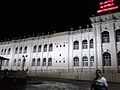
Cooch Behar Palace is built after Classical Italian architecture. The dome of the Palace is in Italian style, resembling the dome of
Post-Independence
Under an agreement between the king of Cooch Behar and the Indian Government at the end of British rule, Maharaja Jagaddipendra Narayan transferred full authority, jurisdiction, and power of the state to the Dominion Government of India, effective 12 September 1949.[8] Eventually, Cooch Bihar became part of the state of West Bengal on 19 January 1950, with Cooch Behar town as its headquarters.[8]
Geography

Cooch Behar is in the foothills of
The
Cooch Behar is a flat region with a slight southeastern slope along which the main rivers of the district flow. Most highland areas are in the Sitalkuchi region, and most low-lying lands lie in the Dinhata region. The elevation of the town is 48 meters above mean sea level. The
, Gadadhar, and Ghargharia.The town of Cooch Behar and its surrounding regions face
In 1976, the Cooch Behar district became home to the Jaldapara Wildlife Sanctuary (now Jaldapara National Park), which has an area of 217 km2 (83.8 sq mi).[23] It shares the park with the Alipurduar district.[23]
Climate
Cooch Behar has a moderate climate characterised by heavy rainfall during the monsoons and slight rainfall from October to March. The city does not experience very high temperatures at any time of the year. The daily maximum temperature is 32.2 °C (90.0 °F) in August, the hottest month, and the daily minimum temperature is 9.4 °C (48.9 °F) in January, the coldest month.[24] The highest temperature in Cooch Behar was 41.0 °C, recorded on 11 September 1977; the lowest temperature recorded was 3.3 °C, reported on 28 January 1982.[24] The atmosphere is highly humid. The rainy season lasts from June to September. The average annual rainfall in the city is 3,562 mm (140.2 in).[24]
| Climate data for Cooch Behar (1981–2010, extremes 1901–2012) | |||||||||||||
|---|---|---|---|---|---|---|---|---|---|---|---|---|---|
| Month | Jan | Feb | Mar | Apr | May | Jun | Jul | Aug | Sep | Oct | Nov | Dec | Year |
| Record high °C (°F) | 29.6 (85.3) |
31.5 (88.7) |
37.6 (99.7) |
39.4 (102.9) |
39.9 (103.8) |
40.3 (104.5) |
38.9 (102.0) |
38.0 (100.4) |
41.0 (105.8) |
36.1 (97.0) |
33.0 (91.4) |
33.4 (92.1) |
41.0 (105.8) |
| Mean maximum °C (°F) | 27.0 (80.6) |
29.1 (84.4) |
34.3 (93.7) |
35.5 (95.9) |
35.1 (95.2) |
35.3 (95.5) |
34.9 (94.8) |
35.6 (96.1) |
34.7 (94.5) |
33.5 (92.3) |
31.3 (88.3) |
28.2 (82.8) |
36.7 (98.1) |
| Mean daily maximum °C (°F) | 23.4 (74.1) |
25.8 (78.4) |
29.6 (85.3) |
30.9 (87.6) |
31.2 (88.2) |
31.6 (88.9) |
31.2 (88.2) |
32.2 (90.0) |
31.2 (88.2) |
30.8 (87.4) |
28.7 (83.7) |
25.6 (78.1) |
29.4 (84.8) |
| Daily mean °C (°F) | 16.4 (61.5) |
18.8 (65.8) |
22.9 (73.2) |
25.4 (77.7) |
26.7 (80.1) |
27.8 (82.0) |
27.9 (82.2) |
28.6 (83.5) |
27.5 (81.5) |
25.8 (78.4) |
22.0 (71.6) |
18.3 (64.9) |
24.0 (75.2) |
| Mean daily minimum °C (°F) | 9.4 (48.9) |
11.9 (53.4) |
16.1 (61.0) |
19.9 (67.8) |
22.2 (72.0) |
24.1 (75.4) |
24.7 (76.5) |
25.0 (77.0) |
23.9 (75.0) |
20.8 (69.4) |
15.3 (59.5) |
11.0 (51.8) |
18.7 (65.6) |
| Mean minimum °C (°F) | 6.7 (44.1) |
8.6 (47.5) |
11.6 (52.9) |
15.9 (60.6) |
18.9 (66.0) |
21.3 (70.3) |
22.5 (72.5) |
22.7 (72.9) |
21.3 (70.3) |
16.6 (61.9) |
11.8 (53.2) |
8.1 (46.6) |
6.5 (43.7) |
| Record low °C (°F) | 3.3 (37.9) |
3.6 (38.5) |
7.1 (44.8) |
10.4 (50.7) |
16.1 (61.0) |
18.2 (64.8) |
20.3 (68.5) |
20.0 (68.0) |
19.7 (67.5) |
13.9 (57.0) |
8.2 (46.8) |
3.9 (39.0) |
3.3 (37.9) |
| Average rainfall mm (inches) | 11.7 (0.46) |
18.5 (0.73) |
45.1 (1.78) |
167.6 (6.60) |
380.0 (14.96) |
683.3 (26.90) |
932.7 (36.72) |
618.2 (24.34) |
521.6 (20.54) |
164.6 (6.48) |
12.2 (0.48) |
7.1 (0.28) |
3,562.6 (140.26) |
| Average rainy days | 0.8 | 1.4 | 2.5 | 8.6 | 14.0 | 18.0 | 21.2 | 16.6 | 15.4 | 5.8 | 0.9 | 0.7 | 105.7 |
| Average relative humidity (%) (at 17:30 IST )
|
70 | 60 | 53 | 62 | 71 | 78 | 81 | 80 | 83 | 79 | 73 | 72 | 72 |
| Source: India Meteorological Department[24][25] | |||||||||||||
Demographics
| Year | Pop. | ±% |
|---|---|---|
| 1951 | 26,299,980 | — |
| 1961 | 34,926,279 | +32.8% |
| 1971 | 44,312,011 | +26.9% |
| 1981 | 54,580,647 | +23.2% |
| 1991 | 68,077,965 | +24.7% |
| 2001 | 80,176,197 | +17.8% |
| 2011 | 91,276,115 | +13.8% |
| Source: [26] | ||
In the 2011 census, Cooch Behar
According to the 2011 census, the Cooch Behar Municipal area has a population of 77,935.[31] The decadal growth rate for the population is 1.38%. The sex ratio is 972 females per 1,000 males.[32] Males constitute 50.6% of the population, and females constitute 49.4%. Cooch Behar has an average literacy rate of 74.78%, higher than the national average of 74.04%. The male literacy rate is 80.71%, while the female literacy rate is 68.49%.[33][34]
The major religions followed in Cooch Behar are
Government and politics
This section may require copy editing. (May 2023) |
Civic administration

Cooch Behar Municipality is responsible for the civic administration of the town. The municipality consists of a board of councillors, elected from each of the 20 wards
The town is in the
Utility services

Cooch Behar is a well-planned town,

Health facilities
The city has one district hospital MJN Hospital which has 400 beds. The hospital has now been converted to
Market facilities
The municipality has four daily markets, two wholesale markets, and eight commercial complexes.[40] Apart from these, two new malls have also opened recently.[41]
Economy
This article needs additional citations for verification. (April 2023) |
The central and state governments are the small number of employers in Cooch Behar town.[42] Cooch Behar is home to several district-level and divisional-level offices and has a large government-employee workforce. Business is mainly centered on retail goods; the main centers lie on B.S. Road, Rupnarayan Road, Keshab Road, and Bhawaniganj Bazar.

An industrial park has been built at Chakchaka, 4 km (2.5 mi) from town, on the route to Tufanganj. A number of companies have set up industries there.[43]
Farming is a significant source of livelihood for the nearby rural populace, and it supplies the town with fruits and vegetables. Poorer sections of this semi-rural society are involved in transport, primary agriculture, small shops, and manual labour in construction.
Cooch Behar has witnessed radical changes and rapid development in segments like industry, real estate, information technology firms, and education since the advent of the twenty-first century. The changes concern infrastructure and industrial growth for steel (direct reduced iron), metal, cement, and knowledge-based industries. Many engineering, technology, management, and professional study colleges have opened at Cooch Behar. Housing co-operatives, flats, shopping malls, hotels, and stadiums have also emerged.
As the town is near the international border, the Border Security Force (BSF) maintains a significant presence in the vicinity. This gives rise to a large population of semi-permanent residents, who bring revenue to the economy. The state government is trying to promote Cooch Behar as a tourist destination. Though income from tourism is low[44] Cooch Behar is one of the major tourist attractions in West Bengal.
Culture

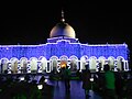
Every year during the Ras Purnima, the city hosts Ras Mela, one of the largest and oldest fairs in West Bengal. The fair is older than 200 years. Cooch Behar Municipality organises the fair in Ras Mela ground near ABN Seal College. During the fair, it becomes a central economic hub of the North Bengal region. Merchants and sellers from all over India and also from Bangladesh join this fair. Earlier, the Maharajas of Cooch Behar used to inaugurate the fair by moving the Ras Chakra, and now the work is executed by the
Novelist Amiya Bhushan Majumdar was born, raised, and worked in Cooch Behar. Cooch Behar, with its people, culture, and the river Torsha was a recurrent theme in his novels. Apart from this, Cooch Behar has a rich history of Debate, Extempore, and Quizzing. A nonprofit organisation named Cobweb is enthusiastically spreading knowledge and facts. They are also fighting against Fake News, the new social evil of this era.[45]
Tourism
Cooch Behar is a significant tourist destination in West Bengal. The main attractions are:
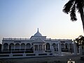
Cooch Behar Palace

It is the main attraction of the city. It was modelled after the
Sagar Dighi

Transport
Road
Cooch Behar is very well connected by road with neighbouring areas and other cities of West Bengal and the rest of the country. Cooch Behar is a major roadway junction after Siliguri towards Northeast India and Bangladesh. NH-17 crosses through the heart of the city connecting Assam and North Bengal. Apart from this, state highways, including SH-16 and SH-12A, pass through Cooch Behar, connecting different places in West Bengal.[48][49]
Bus service

North Bengal State Transport Corporation (NBSTC), a state government-run transport corporation headquartered in Cooch Behar, which runs regular bus service to most places in West Bengal. Private buses are also available, which operate from bus stops or designated pick-up spots to various tows in Assam, Bihar, and West Bengal. City services from NBSTC are also available for riders to commute from different parts of a city.[50][51]
- Mini Bus stand & NBSTC Bus Terminus: Located near Cooch Behar Palace, it serves as a bus depot for both government and private buses. Government buses are operated by NBSTC.
- NBSTC New Bus Stand: Located within the city, it is the hub for NBSTC buses and a boarding point for long-haul buses.[52]
Rail

Being a popular tourism hub,[53] Cooch Behar is well connected through railway with almost all parts of the country. Two stations serve the city.
- New Cooch Behar railway station (NCB): Located around 5 km from the city, it is well connected to almost all major Indian cities including Kolkata, Delhi, Mumbai, Bangalore, Chennai, Guwahati. All Rajdhani, superfast and express trains going towards northeast India have a stoppage here. New Cooch Behar station came up when the broad gauge New Jalpaiguri–New Bongaigaon section of Barauni–Guwahati line was laid in 1966.[54] As of 2018, it is the largest railway junction of Northeast Frontier Railway with six routes towards New Changrabandha, New Jalpaiguri, New Bongaigaon, Alipurduar Junction, Dhubri, and Bamanhat. New Cooch Behar railway station is given a beautiful look similar to Cooch Behar Palace.[55] This station is equipped with Wi-Fi facilities, restrooms, food cafes, dormitory, waiting lounges elevators and escalators.[56]
- Cooch Behar railway station (COB): Situated inside the town, this station lies on the Alipurduar–Bamanhat branch line. Trains connecting Bamanhat with Alipurduar and Siliguri have a halt here. It was built in 1901 when Cooch Behar State Railway constructed the Geetaldaha-Jainti line.[57] The station offers Wi-Fi, seating and other basic facilities. A Railway Heritage Museum, a minuscule version of the National Rail Museum is constructed in the station area, having a look of Cooch Behar Madan Mohan Temple.[58][59]
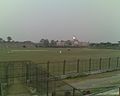
Air

Cooch Behar Airport is a domestic airport located near the city. It handles daily flights from Netaji Subash Chandra Bose International Airport in Kolkata.[60]
The nearest
Education

Cooch Behar's schools usually use English and Bengali as their

There are five colleges and a polytechnic in town,
1981 the
Cooch Behar Government Engineering College started its first academic session in 2016.[69]
Gallery
-
 Indoor Stadium, cooch Behar
 -
 District Court
 -
 ABN Seal College
 -
 Cooch Behar Airport
 -
 Railway Museum near Cooch Behar Station
 -
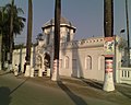
 Palace Gate
 -
 Sahid Bag, Cooch Behar
 -
 Bhola Ashram, Cooch Behar. (Residence of Executive Engineer WBPWD)
 -
 Madan Mohan Bari Entrance
 -
 Circuit House
 -
 New Cooch Behar at night
 -
 New Cooch Behar Junction
 -
 Debi Bari Cooch Behar
 -
 Moti Mahal
 -
 Madanmohan Temple at night
 -
 Palace view from the stadium


.jpg)
.jpg)
.jpg)
.jpg)


.jpg)
.jpg)

.jpg)
See also
- Narendra Narayan Park, a botanical garden in town, founded in 1892
- Cooch Behar Archive
- Cooch Behar Stadium, a multi-purpose stadium
References
addressing link rot or discuss this issue on the talk page. (April 2023) ) |
- ^ "Cooch Behar City". coochbeharmunicipality.com. Archived from the original on 15 February 2020. Retrieved 26 November 2020.
- ^ "Demography | Cooch Behar District | India". Retrieved 1 May 2023.
- ^ a b "Fact and Figures". wb.gov.in. Archived from the original on 14 June 2020. Retrieved 15 January 2019.
- ^ "52nd Report of the Commissioner for Linguistic Minorities in India" (PDF). nclm.nic.in. Ministry of Minority Affairs. p. 85. Archived from the original (PDF) on 25 May 2017. Retrieved 2 March 2019.
- ^ "Kamtapuri, Rajbanshi make it to list of official languages in". India Today. 28 February 2018. Retrieved 11 October 2023.
{{cite magazine}}: Unknown parameter|agency=ignored (help) - ^ "The Portal of North Bengal Development Department". Government of West Bengal. Retrieved 27 July 2023.
- ^ "Heritage Commission, West Bengal". wbhc.in. Archived from the original on 3 May 2023. Retrieved 1 May 2023.
- ^ a b c "Brief Royal History of Cooch Behar 5". Archived from the original on 24 July 2011. Retrieved 22 October 2006.
- ^ Pal, Dr. Nripendra Nath (2000). Itikathai Cooch Behar (A brief history of Cooch Behar). Kolkata: Anima Prakashani. pp. 11–12.
- ^ The name Cooch Behar is a compound of two words: Cooch and Behar. Cooch is a corrupted form of Coch or Koch, the name of an ethnic group inhabiting a vast tract of land to the northeast of Bengal. Behar or, more properly, Vihara denotes abode or sport. Cooch Behar means, therefore, the abode or land of the Koches. Ray, B.. CENSUS 1961 WEST BENGAL Archived 12 October 2022 at the Wayback Machine. GOVERNMENT PRINTING, WEST BENGAL, 1961, p.20
- ISBN 8170991099, archivedfrom the original on 3 May 2023, retrieved 3 May 2023
- ^ "Royal History of Cooch Behar". Archived from the original on 21 July 2011. Retrieved 22 October 2006.
- ^ Pal, Dr. Nripendra Nath (2000). Itikathai Cooch Behar (A brief history of Cooch Behar). Kolkata: Anima Prakashani. p. 68.
- ^ a b Bhattacharyya, PK (2012). "Kamata-Koch Behar". In Islam, Sirajul; Jamal, Ahmed A. (eds.). Banglapedia: National Encyclopedia of Bangladesh (Second ed.). Asiatic Society of Bangladesh. Archived from the original on 16 April 2023. Retrieved 3 May 2023.
- ^ "Old Coins of Bhutan". Mintage World. Archived from the original on 10 October 2021. Retrieved 10 October 2021.
- ^ Pal, Dr. Nripendra Nath (2000). Itikathai Cooch Behar (A brief history of Cooch Behar). Kolkata: Anima Prakashani. p. 73.
- ISBN 0-231-11004-9.
- ^ Pal, Dr. Nripendra Nath (2000). Itikathai Cooch Behar (A brief history of Cooch Behar). Kolkata: Anima Prakashani. p. 75.
- ^ "Royal History of Cooch Behar 5". Archived from the original on 21 July 2011. Retrieved 22 October 2006.
- ^ "West Bengal Census". Archived from the original on 19 July 2011. Retrieved 1 October 2006.
- ^ a b c Annual Plan on Agriculture 2003–04. Cooch Behar: Cooch Behar District Agriculture Office. p. 2.
- ^ "West Bengal Tourism: Cooch Behar". Archived from the original on 15 July 2009.
- ^ a b Indian Ministry of Forests and Environment. "Protected areas: Sikkim". Archived from the original on 23 August 2011. Retrieved 25 September 2011.
- ^ a b c d "Station: Cooch Behar (A) Climatological Table 1981–2010" (PDF). Climatological Normals 1981–2010. India Meteorological Department. January 2015. pp. 207–208. Archived from the original (PDF) on 5 February 2020. Retrieved 10 January 2021.
- ^ "Extremes of Temperature & Rainfall for Indian Stations (Up to 2012)" (PDF). India Meteorological Department. December 2016. p. M233. Archived from the original (PDF) on 5 February 2020. Retrieved 10 January 2021.
- ^ "A-02: Decadal variation in population 1901-2011" (PDF). Office of the Registrar General & Census Commissioner, India. 2011. Archived (PDF) from the original on 30 April 2023. Retrieved 30 April 2023.
- ^ a b "C-01: Population by religious community". Office of the Registrar General & Census Commissioner, India. 2011. Archived (XLS) from the original on 5 April 2023. Retrieved 30 April 2023.
- ^ a b "C-16 City: Population by mother tongue (town level)" (XLS). Registrar General and Census Commissioner of India. 2011. Archived from the original on 1 May 2023. Retrieved 1 May 2023.
- ^ "Demography | Cooch Behar District | India". Archived from the original on 9 February 2023. Retrieved 1 May 2023.
- ^ "C-08: Educational level by age and sex for population age seven and above (total)". Registrar General and Census Commissioner of India. 2011. Archived from the original on 1 May 2023. Retrieved 1 May 2023.
- ^ "Coochbehar Municipality: Population". coochbeharmunicipality.com. Archived from the original on 16 April 2023. Retrieved 1 May 2023.
- ^ "Koch Bihar (Cooch Behar) District Population Census 2011 - 2021 - 2023, West Bengal literacy sex ratio and density". www.census2011.co.in. Archived from the original on 6 April 2023. Retrieved 1 May 2023.
- ^ "What is the literacy rate of Koch Bihar (Cooch Behar) district of West Bengal in 2011 census?". www.census2011.co.in. Archived from the original on 12 November 2017. Retrieved 1 May 2023.
- ^ "Profile - Literacy - Know India: National Portal of India". knowindia.india.gov.in. Archived from the original on 15 April 2023. Retrieved 1 May 2023.
- ^ District Administration Archived 3 August 2011 at the Wayback Machine Accessed on 1 October 2006
- ^ "Press Note, Delimitation Commission" (PDF). Assembly Constituencies in West Bengal. Delimitation Commission. pp. 4, 23. Archived (PDF) from the original on 8 January 2011. Retrieved 18 April 2009.
- ^ "North Bengal: Cooch Behar". Archived from the original on 8 November 2006. Retrieved 7 November 2006.
- ^ "Rush to start Cooch Behar medical college". Archived from the original on 8 June 2019. Retrieved 9 September 2019.
{{cite web}}: CS1 maint: bot: original URL status unknown (link) - ^ "Subham Hospital & Diagnostic Centre (P) Ltd. | National Health Portal of India". nhp.gov.in. Archived from the original on 22 October 2021. Retrieved 22 October 2021.
- ^ "Social Infrastructure". Archived from the original on 26 August 2019. Retrieved 9 September 2019.
- ^ prmgroup.co.in. "Retail Projects PRM Group". prmgroup.co.in. Archived from the original on 22 October 2021. Retrieved 22 October 2021.
- ^ "Employment in Cooch Behar". coochbehar.nic.in. Archived from the original on 1 May 2022. Retrieved 29 April 2022.
- ^ Industries in Cooch Behar Archived 27 March 2007 at the Wayback Machine, Cooch Behar Government Website Archived 15 July 2010 at the Wayback Machine Accessed on 1 October 2006
- ^ Tourism Development in Cooch Behar Archived 27 March 2007 at the Wayback Machine, Cooch Behar Government Website Archived 15 July 2010 at the Wayback Machine Accessed on 1 October 2006
- ^ hawabari.com
- ^ "Rajbari in Cooch Behar town". Archived from the original on 14 August 2022. Retrieved 3 May 2023.
- ^ "Tourist places of Cooch Behar". Archived from the original on 10 August 2022. Retrieved 3 May 2023.
- ^ "State Highways in West Bengal". www.wbtrafficpolice.com. Archived from the original on 29 April 2023. Retrieved 29 April 2023.
- ^ "Road-State Highway". wbpwd.gov.in. Archived from the original on 29 April 2023. Retrieved 29 April 2023.
- ^ "NBSTC Bus routes" (PDF). nbstc.in/. Archived (PDF) from the original on 1 February 2023. Retrieved 29 April 2023.
- ^ "About - North Bengal State Transport Corporation". nbstc.in. Archived from the original on 1 February 2023. Retrieved 1 May 2023.
- ^ "Depots & Divisions - North Bengal State Transport Corporation". nbstc.in. Retrieved 5 April 2024.
- ^ "COOCHBEHAR - West Bengal Tourism, Experience Bengal, Dept. of Tourism, Govt. of W. B." wbtourism.gov.in. Archived from the original on 26 November 2022. Retrieved 29 April 2023.
- ^ "Some Milestones of NF Railway". Archived from the original on 24 November 2011. Retrieved 28 January 2012.
- ^ "New Cooch Behar railway station gets facade of local palace". www.telegraphindia.com. Archived from the original on 3 May 2023. Retrieved 29 April 2023.
- from the original on 3 May 2023. Retrieved 29 April 2023.
- ^ "[IRFCA] The State Railways of Cooch Behar (1903)". www.irfca.org. Archived from the original on 28 November 2022. Retrieved 29 April 2023.
- ^ "Construction of Railway Heritage Museum starts". COOCHBEHAR CALLING. 10 March 2011. Archived from the original on 23 March 2017. Retrieved 29 April 2023.
- ^ "Rail Museum at Cooch Behar" (PDF). nfr.indianrailways.gov.in. Archived (PDF) from the original on 29 April 2023. Retrieved 29 April 2023.
- from the original on 31 March 2023. Retrieved 29 April 2023.
- ^ "Coochbehar Panchanan Barma University :: Home". Archived from the original on 22 April 2023. Retrieved 3 May 2023.
- ^ "COOCHBEHAR GOVERNMENT ENGINEERING COLLEGE, COOCH BEHAR". Archived from the original on 29 December 2019. Retrieved 9 September 2019.
- ^ Education in Cooch Behar Archived 21 July 2011 at the Wayback Machine, Cooch Behar Government Website Archived 15 July 2010 at the Wayback Machine Accessed on 1 October 2006
- ^ "Private education Bill passed amidst Opposition walkout". The Statesman. 6 July 2012. Archived from the original on 20 December 2012. Retrieved 7 July 2012.
- ^ "Bill passed to set up private varsity". Asian Age. 7 July 2012. Archived from the original on 11 December 2017. Retrieved 7 July 2012.
- ^ "Acharya Brojendra Nath Seal College". Archived from the original on 16 December 2014. Retrieved 9 September 2019.
{{cite web}}: CS1 maint: bot: original URL status unknown (link) - ^ Maya Chitram Art Institute.[permanent dead link] India for You. Retrieved 19 August 2012.
- ^ "CM inaugurates Maharaja Jitendra Narayan Medical College & Hospital in Cooch Behar". Millennium Post. 16 December 2020. Retrieved 13 September 2023.
- ^ EOI, Correspondence. "NBDD minister inaugurates multiple projects in Cooch Behar". Archived from the original on 14 January 2015.
External links
![]() Cooch Behar travel guide from Wikivoyage
Cooch Behar travel guide from Wikivoyage
Cities and towns in Cooch Behar district | |||||||||||
|---|---|---|---|---|---|---|---|---|---|---|---|
| Cities, municipal and census towns |
| ||||||||||
| Locations other than cities and towns |
| ||||||||||
| Related topics |
| ||||||||||
| Part A States | ||
|---|---|---|
| Part B States | ||
| Part C States | ||
| Part D States | ||
| International | |
|---|---|
| National | |