
Coolidge, Arizona
Coolidge | |
|---|---|
City | |
 Original 1939 Coolidge High School | |
|
DST | |
| ZIP code | 85128 |
| Area code | 520 |
| FIPS code | 04-15500 |
| GNIS ID | 2410221[2] |
| Website | "Coolidge AZ". coolidgeaz.com. |
Coolidge is a city in Pinal County, Arizona, United States. According to the 2020 census, the city's population is 13,218.[3]
Coolidge is home of the
History
The area containing what is now the City of Coolidge was occupied by the Hohokam, an indigenous ancient Sonoran Desert people who built a massive compound consisting many of caliche structures and remained in the area for over 1,000 years. The only remaining and preserved structure from this compound is the Casa Grande Ruins National Monument.
The modern history of the city is centered around agriculture, particularly cotton. Coolidge was founded in 1925 when R.J. Jones laid out an 80 acres (32 ha) site during the construction of the

Economy
Up until the 1950s, the city's economy was completely dependent on mining and cotton. It has since diversified to include manufacturing,
In 2019,
Geography
According to the
Arizona State Route 87 and Arizona State Route 287 pass through the town, providing connections to the Phoenix metropolitan area, Casa Grande, and Eloy. Interstate 10 is located approximately 10 miles (16 km) to the west. Coolidge is 56 miles (90 km) southeast of Phoenix, 69 miles (111 km) northwest of Tucson, 21 miles (34 km) northeast of Casa Grande and 11 miles southwest of Florence. Picacho Reservoir is just 11 miles (18 km) south of town.
Climate
Coolidge features a hot
| Climate data for Casa Grande Ruins National Monument, Arizona (1991–2020 normals, extremes 1908–1916 and 1932–present) | |||||||||||||
|---|---|---|---|---|---|---|---|---|---|---|---|---|---|
| Month | Jan | Feb | Mar | Apr | May | Jun | Jul | Aug | Sep | Oct | Nov | Dec | Year |
| Record high °F (°C) | 89 (32) |
93 (34) |
100 (38) |
106 (41) |
116 (47) |
123 (51) |
123 (51) |
120 (49) |
115 (46) |
111 (44) |
97 (36) |
89 (32) |
123 (51) |
| Mean maximum °F (°C) | 78.8 (26.0) |
82.7 (28.2) |
90.8 (32.7) |
99.2 (37.3) |
106.8 (41.6) |
113.9 (45.5) |
114.8 (46.0) |
113.1 (45.1) |
108.9 (42.7) |
102.0 (38.9) |
89.9 (32.2) |
79.1 (26.2) |
116.1 (46.7) |
| Mean daily maximum °F (°C) | 67.6 (19.8) |
71.3 (21.8) |
78.2 (25.7) |
86.4 (30.2) |
95.2 (35.1) |
105.1 (40.6) |
106.6 (41.4) |
104.9 (40.5) |
100.7 (38.2) |
90.5 (32.5) |
77.8 (25.4) |
66.9 (19.4) |
87.6 (30.9) |
| Daily mean °F (°C) | 52.3 (11.3) |
55.5 (13.1) |
61.7 (16.5) |
68.6 (20.3) |
77.2 (25.1) |
86.6 (30.3) |
91.8 (33.2) |
90.8 (32.7) |
85.2 (29.6) |
73.4 (23.0) |
60.8 (16.0) |
51.6 (10.9) |
71.3 (21.8) |
| Mean daily minimum °F (°C) | 37.0 (2.8) |
39.7 (4.3) |
45.2 (7.3) |
50.8 (10.4) |
59.2 (15.1) |
68.0 (20.0) |
77.1 (25.1) |
76.6 (24.8) |
69.8 (21.0) |
56.3 (13.5) |
43.7 (6.5) |
36.3 (2.4) |
55.0 (12.8) |
| Mean minimum °F (°C) | 26.1 (−3.3) |
29.0 (−1.7) |
33.6 (0.9) |
38.5 (3.6) |
46.5 (8.1) |
56.3 (13.5) |
66.5 (19.2) |
66.7 (19.3) |
56.6 (13.7) |
42.7 (5.9) |
29.1 (−1.6) |
25.7 (−3.5) |
23.0 (−5.0) |
| Record low °F (°C) | 8 (−13) |
11 (−12) |
21 (−6) |
25 (−4) |
32 (0) |
44 (7) |
51 (11) |
55 (13) |
37 (3) |
25 (−4) |
17 (−8) |
14 (−10) |
8 (−13) |
| Average precipitation inches (mm) | 0.98 (25) |
1.02 (26) |
0.94 (24) |
0.25 (6.4) |
0.20 (5.1) |
0.06 (1.5) |
1.12 (28) |
1.24 (31) |
0.70 (18) |
0.48 (12) |
0.49 (12) |
0.77 (20) |
8.25 (210) |
| Average precipitation days | 4.4 | 4.2 | 3.2 | 1.4 | 1.3 | 0.6 | 4.7 | 5.3 | 3.3 | 2.2 | 2.0 | 4.2 | 36.8 |
| Source: | |||||||||||||
Demographics
| Census | Pop. | Note | %± |
|---|---|---|---|
| 1960 | 4,990 | — | |
| 1970 | 5,314 | 6.5% | |
| 1980 | 6,851 | 28.9% | |
| 1990 | 6,934 | 1.2% | |
| 2000 | 7,786 | 12.3% | |
| 2010 | 11,825 | 51.9% | |
| 2020 | 13,218 | 11.8% | |
| 2022 (est.) | 16,711 | [10] | 26.4% |
| U.S. Decennial Census[11] | |||
As of the census[12] of 2000, there were 7,786 people, 2,585 households, and 1,938 families residing in the city. The population density was 1,549.1 inhabitants per square mile (598.1/km2). There were 3,212 housing units at an average density of 639.1 per square mile (246.8/km2).
The racial makeup of the city was 57.9%
There were 2,585 households, out of which 38.5% had children under age 18 living with them, 48.8% were married couples living together, 19.3% had a female householder with no husband present, and 25.0% were non-families. 20.8% of all households were made up of individuals, and 9.9% had someone living alone who was 65 years of age or older. The average household size was 3.00 and the average family size was 3.44.

In the city, the population was spread out, with 32.9% under age 18, 10.4% aged 18–24, 24.4% aged 25–44, 18.9% aged 45–64, and 13.4% who were aged 65 years or older. The median age was 31 years. For every 100 females, there were 93.2 males. For every 100 females age 18 and over, there were 88.1 males.
The median income for a household in the city was $29,049, and the median income for a family was $33,536. Males had a median income of $29,159 versus $21,472 for females. The per capita income for the city was $13,663. About 20.9% of families and 24.7% of the population were below the poverty line, including 30.9% of those under age 18 and 20.5% of those age 65 or over.
In 2010, Coolidge had a population of 11,825. The racial and ethnic composition of the population was 43.6% non-Hispanic white, 7.3% non-Hispanic black, 0.5% Hispanic blacks, 3.8% non-Hispanic Native American, 1.9% Hispanic or Latino Native American, 1.0% Asian, 0.1% Pacific Islander, 0.1% non-Hispanic from some other race, 5.0% from two or more races and 42.0% Hispanic or Latino.[13]
Education
- Coolidge High School, a high school located in the central part of the city.
- West Elementary School, a K-5 school located in the western part of the city.
- Imagine Schools Coolidge Elementary, a K-5 charter school located in the northern part of the city.
- Imagine Prep Coolidge, a 6–12 charter school located adjacent to Imagine Coolidge Elementary.
- Central Arizona College
- Central Arizona Valley Institute of Technology
- Coolidge Junior High School, a junior high school with grades 6-8
Transportation
The City of Coolidge operates the Cotton Express, which provides local bus service.[14] The City of Coolidge also operates Central Arizona Regional Transit (CART), which provides transportation between Florence, Coolidge, Central Arizona College and Casa Grande.[15]
The town was home to
The
Notable people
- Duane Eddy – rock & roll guitarist and record producer, Coolidge High School graduate[18]
- Country Music Hall of Fame
- Sammi Smith – country music recording artist and songwriter[19]
Historic properties
-
 The Casa Grande Ruins are located at Ruins Drive in Coolidge, Az. Built by the Hohokam, the Casa Grande was abandoned around 1450 CE. Written historic accounts of the Casa Grande begin with the journal entries of Padre Eusebio Francisco Kino when he visited the ruins in 1694. Listed in the National Register of Historic Places in 1966, and reference #66000192.
 -
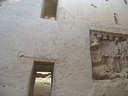 Inside the Casa Grande Big House Ruins
 -
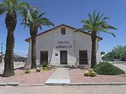 The Coolidge Woman's Club (Building) was built in 1925 and is located at 240 W. Pinkley Ave., Coolidge, Arizona. The building was listed in the National Register of Historic Places in 1990, reference #900015924.
 -
 Historic Coolidge High School built in 1939 and NRHP eligible. The building now houses the offices of the Coolidge Unified School District No. 21.


See also
- Central Arizona College
- Central Arizona Valley Institute of Technology
- Coolidge Municipal Airport
- Coolidge Dam
References
- ^ "2020 U.S. Gazetteer Files". United States Census Bureau. Retrieved October 29, 2021.
- ^ a b U.S. Geological Survey Geographic Names Information System: Coolidge, Arizona
- ^ "U.S. Census website". United States Census Bureau. Retrieved August 5, 2014.
- ^ "Coolidge". visitarizona.com.
- ^ "Coolidge". azcommerce.com.
- ^ "Nikola Motor Co. buys land – Coolidge Arizona factory to build zero-emission trucks". The Arizona Republic. March 22, 2019.
- ^ "Nikola Tre wins eligibility for $185k New York Truck Voucher Incentive". June 9, 2022.
- ^ "NOWData – NOAA Online Weather Data". National Oceanic and Atmospheric Administration. Retrieved November 19, 2022.
- ^ "Summary of Monthly Normals 1991–2020". National Oceanic and Atmospheric Administration. Retrieved November 19, 2022.
- ^ "City and Town Population Totals: 2020-2022". Retrieved April 14, 2024.
- ^ "Census of Population and Housing". Census.gov. Retrieved June 4, 2016.
- ^ "U.S. Census website". United States Census Bureau. Retrieved January 31, 2008.
- ^ 2010 census report on race, Hispanic or Latino, age and housing occupancy for Coolidge[full citation needed]
- ^ "Cotton Express – Coolidge, AZ". Retrieved January 27, 2020.}
- ^ "Ride The Cart – Partnership in Motion". Retrieved January 27, 2020.
- PDF, effective December 3, 2020
- ^ "Our Rates and Van Schedule | Casa Grande Shuttle". Retrieved November 10, 2021.
- ISBN 0-214-20512-6.
- ^ Lamb, Bill. "The Story of Singer and Songwriter Sam Smith". LiveAbout. Retrieved May 30, 2019.
External links
- Official website
- "Casa Grande Ruins National Monument". National Park Service.
- "Casa Grande Ruins". azohwy.com. Online Highways.
- "Pinal Geology and Mineral Museum". pinalgeologymusuem.org. Coolidge, AZ.
 | ||||
Towns | ||||
| CDPs |
| |||
| Populated places | ||||
| Indian reservations | ||||
| Ghost towns | ||||
| Footnotes | ‡This populated place also has portions in an adjacent county or counties | |||
| ||||
| International | |
|---|---|
| National | |
| Other | |