
Copacabana, Bolivia
This article needs additional citations for verification. (June 2022) |
Copacabana
Kotakawana | ||
|---|---|---|
FIPS code 45-16000[1] | | |
| Climate | Cwc | |
| GNIS feature ID | 1245051[2] | |
Copacabana is the main
History
_1877_George_Squier.jpg)
During the
Before 1534, Copacabana was an outpost of Inca occupation among dozens of other sites in Bolivia. The Incas held it as the key to the very ancient shrine and oracle on the Island of Titicaca, which they had adopted as a place of worship, adopting the veneration with which it was held by the
In 1582, the grandson of Inca ruler
During the Great Indigenous Uprising of 1781, while the church itself was desecrated, the "Camarin", as the chapel is called, remained untouched and exempt from spoiling. Copacabana is the scene of often boisterous indigenous celebrations. On 2 February and 6 August, Church festivals are celebrated with indigenous dances that the clergy have not been able to suppress entirely. Copacabana is surrounded by pre-Columbian ruins of considerable interest.
Climate
Copacabana has a
| Climate data for Copacabana, Bolivia, elevation: 3,815 metres (12,516 ft), 1981–2010 normals, extremes 1943–present | |||||||||||||
|---|---|---|---|---|---|---|---|---|---|---|---|---|---|
| Month | Jan | Feb | Mar | Apr | May | Jun | Jul | Aug | Sep | Oct | Nov | Dec | Year |
| Record high °C (°F) | 27.0 (80.6) |
23.0 (73.4) |
23.0 (73.4) |
28.0 (82.4) |
28.0 (82.4) |
28.0 (82.4) |
28.0 (82.4) |
27.0 (80.6) |
27.0 (80.6) |
23.5 (74.3) |
26.0 (78.8) |
25.6 (78.1) |
28.0 (82.4) |
| Mean daily maximum °C (°F) | 15.1 (59.2) |
15.2 (59.4) |
15.1 (59.2) |
14.9 (58.8) |
14.4 (57.9) |
13.4 (56.1) |
13.3 (55.9) |
14.0 (57.2) |
14.7 (58.5) |
15.5 (59.9) |
16.0 (60.8) |
16.0 (60.8) |
15.0 (59.0) |
| Daily mean °C (°F) | 10.2 (50.4) |
10.2 (50.4) |
10.2 (50.4) |
9.8 (49.6) |
8.9 (48.0) |
7.8 (46.0) |
7.7 (45.9) |
8.3 (46.9) |
8.9 (48.0) |
10.0 (50.0) |
10.5 (50.9) |
10.7 (51.3) |
9.5 (49.1) |
| Mean daily minimum °C (°F) | 5.3 (41.5) |
5.2 (41.4) |
5.3 (41.5) |
4.8 (40.6) |
3.4 (38.1) |
2.2 (36.0) |
2.1 (35.8) |
2.7 (36.9) |
3.2 (37.8) |
4.5 (40.1) |
5.1 (41.2) |
5.4 (41.7) |
4.0 (39.2) |
| Record low °C (°F) | −5.0 (23.0) |
−4.0 (24.8) |
−5.5 (22.1) |
−6.5 (20.3) |
−6.5 (20.3) |
−7.5 (18.5) |
−8.0 (17.6) |
−9.0 (15.8) |
−8.0 (17.6) |
−7.0 (19.4) |
−6.5 (20.3) |
−4.5 (23.9) |
−9.0 (15.8) |
| Average precipitation mm (inches) | 184.7 (7.27) |
113.0 (4.45) |
111.5 (4.39) |
52.4 (2.06) |
16.0 (0.63) |
11.5 (0.45) |
9.2 (0.36) |
16.7 (0.66) |
28.7 (1.13) |
45.5 (1.79) |
63.4 (2.50) |
108.8 (4.28) |
780.7 (30.74) |
| Average precipitation days | 19.4 | 13.6 | 13.3 | 7.8 | 2.4 | 2.3 | 1.7 | 2.8 | 5.2 | 6.5 | 8.1 | 13.0 | 97.1 |
| Average snowy days | 0.0 | 0.0 | 0.0 | 0.0 | 0.0 | 0.0 | 0.0 | 0.0 | 0.0 | 0.0 | 0.0 | 0.0 | 0.0 |
| Average relative humidity (%)
|
66.5 | 66.0 | 66.1 | 62.7 | 57.6 | 56.7 | 55.0 | 56.2 | 56.0 | 56.6 | 57.3 | 60.7 | 59.4 |
| Source: Servicio Nacional de Meteorología e Hidrología de Bolivia[3] | |||||||||||||
Gallery
-
 View of Copacabana from Lake Titicaca
 -
 Copacabana's famous Basilica, Basilica of Our Lady of Copacabana.
 -
 Copacabana with the Basilica.
 -
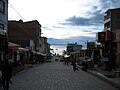 Shopping street with Lake Titicaca in the background.
 -
 Copacabana.
 -
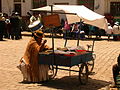
 Street Butcher, Copacabana Bolivia
.jpg)


.JPG)

Places of interest
References
- ^ "U.S. Census website". United States Census Bureau. Retrieved 2008-01-31.
- ^ "US Board on Geographic Names". United States Geological Survey. 2007-10-25. Retrieved 2008-01-31.
- ^ "Base de datos Sistema Meteorológico–SISMET" (in Spanish). Servicio Nacional de Meteorología e Hidrología de Bolivia. Archived from the original on 21 September 2019. Retrieved 25 September 2019.
External links
- Weather in Copacabana Archived 2020-10-06 at the Wayback Machine
 Herbermann, Charles, ed. (1913). "Copacavana". Catholic Encyclopedia. New York: Robert Appleton Company.
- Bolivia Weekly Bolivia News
- Lake Titicaca travel guide

| International | |
|---|---|
| National | |