
Coropuna
| Coropuna | |
|---|---|
| Nevado Coropuna | |
Quechua) | |
| English translation | "Golden mountain", "cold, snowy" or "cut off at the top" |
| Geography | |
 Coropuna | |
Central Volcanic Zone | |
| Last eruption | 1,100 ± 100 or 700 ± 200 years ago |
| Climbing | |
| First ascent | possibly prehistoric |
Coropuna is a
The Coropuna complex consists of several
Coropuna is located 150 kilometres (93 mi) northwest of the city of Arequipa. People have lived on the slopes of Coropuna for millennia. The mountain was regarded as sacred by the Inca, and several archaeological sites have been discovered there, including the Inca sites of Maucallacta and Acchaymarca. The mountain was considered one of the most important Inca religious sites in their realm; human sacrifices were performed on its slopes, Coropuna forms part of many local legends and the mountain is worshiped to the present day.
The ice cap of Coropuna, which during the Last Glacial Maximum (LGM) had expanded to over 500 km2 (190 sq mi), has been in retreat since at least 1850. Estimates published in 2018 imply that the ice cap will persist until about 2120. The retreat of the Coropuna glaciers threatens the water supply of tens of thousands of people relying upon its watershed, and interaction between volcanic activity and glacial effects has generated mudflows that could be hazardous to surrounding populations. Because of this, the Peruvian geological agency, INGEMMET, monitors Coropuna and has published a hazard map for the volcano.
Name and etymology
In Quechua, puna means "plateau", and coro is a common component of toponyms such as with Coro Coro, Bolivia, though its etymology is unclear.[5] The name may mean Qoripuna, "Puna of Gold",[6] "golden mountain",[7] "cold, snowy" or "cut off at the top".[8] The name is also spelled Qhuru Puna.[9] The mountain is also called Nevado Coropuna; "Nevado" is the Spanish word for "snowy".[10] There is another volcano in the Andahua volcanic field which has the same name, but is completely separate.[11]
Geography and geomorphology
Coropuna lies in the
Regional
The Andes stretch along the western coast of South America from Tierra del Fuego northwards to Venezuela, forming the longest mountain chain in the world.[18] More regionally, the volcano is in the Cordillera Ampato, a mountain range which lies at an average of 100 kilometres (62 mi) from the Pacific coastline,[19] and contains nearly one hundred glaciers.[20]
Coropuna is in the
There is no habitation on Coropuna above 5,200 metres (17,100 ft),[27] but numerous villages dot the lower slopes.[c] Agriculture and animal husbandry are the most common economic activities;[29] there are copper and gold mines as well.[30] The city of Arequipa lies 150 km (93 mi) to the southeast.[12]
Local
General outline

Seen from above, Coropuna has a pear-shaped outline[31] and is a 20 km (12 mi) east–west ridge[14] that features four summits that are separated by broad saddles.[12][32] In addition, there is another summit north of the east–west trend.[1] A 5,558 m (18,235 ft) high subsidiary peak named Cerro Cuncaicha lies east of Coropuna;[33] it is a stratovolcano.[34] Coropuna covers a surface area of 240 square kilometres (93 sq mi)[35] and its various main summits rise about three kilometres (1.9 mi) above the surrounding plateau.[23]
The volcano is formed from alternating layers of
The higher elevations of Coropuna consist of an ice cap and glaciated terrain
There are several collapse scarps on the mountain, especially around its central sector.[34] A sector collapse took place on the southwestern flank and formed a landslide deposit as well as a horseshoe-shaped valley that was later filled by glaciers.[45] Also on the southern side, mud-water flow deposits have been found in the Capiza River valley and appear to relate to Coropuna;[46] at least eight such debris flows have been identified.[47] Lahars (mudflows) have reached the Colca River valley.[48] Lahars are dangerous phenomena owing to their high speed and density, causing large scale destruction and fatalities,[46] and can be generated both by volcanic and meteorological processes.[49]
Lakes and rivers

Lakes lie on the flanks of the volcano.
The volcano is situated on a
Surrounding terrain
Coropuna rises two km (1.2 mi) above the surrounding terrain[2][32] from a base elevation of 4,500 m (14,800 ft),[14] and about 3.5 km (2.2 mi) on the southern side where the Rio Llacllaja has incised the underlying basement[2][32] almost to the foot of the volcano, forming sharp, amphitheatre-like valleys.[55] In general, many deep valleys cut into the flanks of the volcano[58] and give the mountain an "impressive topographic relief".[1]
The region is characterised by high plateaus separated by deep canyons, including some of the world's deepest gorges[52] that reach depths of 600–3,000 m (2,000–9,800 ft).[59] Apart from river erosion, giant landslides have affected the Altiplano below Coropuna,[60] such as the Chuquibamba landslide, which took place over the last 120,000 years in the form of multiple collapse events within a fault-controlled basin.[61]
Geomorphologically, Coropuna lies at the edge of the Altiplano high plateau on the
Elevation and size
.jpg)
Coropuna is the largest[66] and highest volcano in Peru, the highest peak of the Cordillera Ampato[2] and the third-highest mountain in Peru.[6][7] The highest point of Coropuna is the northwestern dome[1][35] named Coropuna Casulla,[15] with 6,377 metres (20,922 ft) elevation.[1][67][40] Mountaineering sources also cite an elevation of 6,425 m (21,079 ft) for the El Toro summit,[68][69] which would make Coropuna the 22nd highest mountain in the Andes.[22][d]
Estimates on the height of Coropuna have changed over time. In the 19th century, it was one of the candidates for "highest mountain in Peru", with the Mapa del Perú (Map of Peru) of
Coropuna has several summits (up to ten overall according to one count)[31] which exceed 6,000 m (20,000 ft) elevation,[56] plus a 5,623 m (18,448 ft) northern summit.[15] Those with individual names are the northwestern Coropuna Casulla at 6,377 m (20,922 ft),[35] El Toro,[68][69] the western Nevado Pallacocha at 6,171 m (20,246 ft), the central Coropuna Central II at 6,161 m (20,213 ft),[77] Escalera at 6,171 m (20,246 ft) in the western sector of the volcano, Paiche at 6,330 m (20,770 ft) in the central sector,[78][34] and Coropuna Este[79] and Yana Ranra at 6,305 m (20,686 ft) in the eastern sector.[34][78]
Ice cap

Coropuna features the largest ice cap of the tropics.[46] As of 2014 it was 8.5 km (5.3 mi) wide and eleven km (6.8 mi) long.[80] It is larger than the Quelccaya Ice Cap 250 km (160 mi) farther northeast, which was considered to be the largest,[80][81] but has since shrunk to a size less than Coropuna's.[82] A subsidiary peak named Cerro Cuncaicha, east of Coropuna, has a small ice cap as well.[83] In general, Peruvian glaciers form the bulk of the world's tropical glaciers.[84] The ice cap consists of three ice domes and many glaciers.[80] Perennial snow fields are present on Coropuna, sometimes making it hard to measure the true extent of glaciation or glacier retreat.[32]
On average, the ice cap of Coropuna is about 80.8 m (265 ft) thick,
Penitentes[19] reaching heights of two m (6 ft 7 in)[91] and seracs (blocks of ice in glaciers delimited by cracks) occur on the glaciers,[28] while debris cover is rare.[92] Mudflows (lahars) originated from the ice cap[2] and left deposits at the bottom of valleys.[58]
Glaciers and periglacial phenomena
A number of glaciers flow down from the ice cap,
Glaciers descend to elevations of about 5,100 to 5,300 m (16,700 to 17,400 ft) on the southern flank, and to about 5,500 to 5,800 m (18,000 to 19,000 ft) on the northern flank.[12][37][80] This is higher than the freezing level, owing to the dry climate;[2] the freezing level at Coropuna lies at about 4,900 m (16,100 ft) elevation.[32] In 2001, the ice limits were located at elevations of 5,300 m (17,400 ft) on the southern and at 5,600 m (18,400 ft) on the northern flank.[97]
Apart from normal glaciers, 78
Recent area and retreat

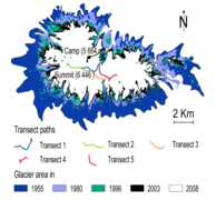
Measuring the surface area of Coropuna's ice cap is difficult as seasonal snow can be mistaken for ice,[105] and different studies come to various conclusions about the retreat rate, due to the use of different time periods and methodological practices. However, all studies conclude that the net retreat trend is obvious and that the ice cap is diminishing.[106] Retreat rates shortly before 2009 reached 13 per cent in only 21 years.[107] Between 1980 and 2014 the ice cap shrank at a rate of 0.409 km2/a (0.158 sq mi/a)[80] with a 2015 estimate amounting to 0.5 km2/a (0.19 sq mi/a),[108] and a brief slowdown observed during the late 1990s and early 2000s.[109] Total shrinkage has been estimated to amount to 26 per cent between 1962 and 2000, and by 18 per cent between 1955 and 2007.[2] Retreat is faster on the northern side of the mountain.[110]
The Coropuna ice cap retreat follows the pattern recorded elsewhere in Peru such as in the Cordillera Blanca,
-
 Glacier trends and extrapolation
 -
 Ice profile
 -
 Ice thickness
 -
 Ice schematics


Glacial history
Before the first human settlement of the area,
Regional climate oscillations are recorded in the ice masses of Coropuna.[119] The glacial history of the volcano has been reconstructed with tephrochronology (using dated tephra layers such as those from the 1600 Huaynaputina eruption), radiocarbon dating[37] and surface exposure dating using helium-3.[32] Three separate moraine generations[34] and about five separate glacial stages have been recorded on the volcano.[120] Glacial advances on Coropuna appear to be synchronous to advances of the ice sheets in the Northern Hemisphere.[121] Glaciers developed on other mountains in the region as well.[122]
Last glacial maximum
During the
The LGM ice cap had an area of at least 365 km2 (141 sq mi), with glaciers descending to 3,780–4,540 m (12,400–14,900 ft) elevation. Glacier ends were lower on the northern
Other glacial periods
Ice has been present on Coropuna for at least 80,000 years.
Glaciers retreated after the end of the last glacial maximum 20,000–18,000 years ago and then re-expanded.
Importance as a source of water
Glaciers in Peru are important sources of water for local communities and for
Geology
Regional setting

Off the coast of Peru, the Nazca Plate subducts beneath the South American Plate at a rate of five–seven centimetres per year (2.0–2.8 in/year)[143] or nine centimetres per year (3.5 in/year).[144] This subduction process, along with the subduction of the Antarctic Plate also underneath the South American Plate, is responsible for the volcanism in the Andes and the uplift of the mountain chain.[145] In the Cordillera Occidental (Western Cordillera) uplift commenced about 50 million years ago in the Eocene, paused until 25 million years ago in the Oligocene, and increased substantially after about 10 million years ago in the Miocene.[146] Andean uplift in the area of Coropuna is ongoing.[31]
Coropuna is part of the volcanic arc of southern Peru[46] and is considered to be a member of the Barroso volcanic arc.[97] There are over six hundred volcanoes in southern Peru,[147] and the entire Cordillera Occidental from southern Peru to northern Chile is covered with volcanic rocks, although present-day volcanic activity is scarce.[55] Many of the older volcanoes are deeply eroded by glaciation, while younger volcanoes often still resemble cones.[63]
Volcanic activity in the Andes occurred during three eras. The first was between 195 and 190 million years ago in the Early Jurassic, and generated the Chocolate Formation. The second between 78 and 50 million years ago (Late Cretaceous to Early Eocene) generated the Toquepala Formation and the Andean batholiths.[146] Volcanic activity in southern Peru commenced about 13 million years ago in the Miocene.[148] One volcanic unit – after being folded and eroded – was covered by a second lava and tuff unit, which in turn was followed by the emplacement of large volcanoes.[63] Ignimbrites and stratovolcano activity, at times subdivided into a "rhyolitic" and an "andesitic" formation, alternated.[55]
Basement
Coropuna is constructed atop of 14 million year old ignimbrites
Faults and lineaments
The basement is cut by faults and
Composition
The rocks released by Coropuna are dark brown to black and
The volcanic rocks define a
Eruption history
The beginning of Coropuna's growth has variously been placed over 5 million years ago,[162] during the Pliocene[163] or late Miocene, but most of its structure developed during the Quaternary.[12] Volcanic activity has been subdivided into two stages: explosive eruptions during the now mostly eroded Coropuna I stage produced volcanic ash, pyroclastic flows and pumice but also lava flows, while Coropuna II above 6,000 m (20,000 ft) elevation erupted lava flows from the now snow-covered vents.[57][164] The existence of a Coropuna III sequence has been proposed.[157] The most recent eruption products have been described as the "Andahua Group".[165] About 5.3 million years ago, the Sunjillpa volcano was active southwest from Coropuna,[34] while Cunciacha east of Coropuna is of lower Pleistocene[78] and Pumaranra of Pliocene to Quaternary age.[57]
A major ignimbrite eruption took place about 2 million years ago at Coropuna; its deposits have been identified west of the volcano[166][43] and it led to the destruction of the edifice, which later re-formed on the remains of the old volcano.[55] The occurrence of explosive eruptions during a mostly effusive activity has been found at Chachani and Sara Sara as well.[55]
In addition, the Upper Sencca Ignimbrite, the Lower Sencca Ignimbrite
After a hiatus,
Holocene
No eruptions of Coropuna during historical[175] or modern times are known,[137] and the volcano was considered to be long-extinct.[39] However, young-looking[38] ʻaʻā lava[176] or block lava[23] flows erupted during the Holocene and in part overlie late-glacial moraines.[12][157][176] Their vents are now hidden beneath glacier ice,[22] and the flows have been affected by later glacial advances.[177] These lava flows are found on the west–northwest, south–southeast and northeast side of the mountain:[83]
- A northwesterly lava flow – Coropuna's longestLate Glacial period.[178]
- A southeasterly flow lies in the Cospanja valley and is either 1,100 ± 100
- A dark, young-looking lava[181] flow runs northeasterly[33] in the Queñua Ranra valley[57] and is five kilometres (3.1 mi) long.[182] The eruption took place about 2,100 ± 200 years ago[183] according to cosmogenic isotope dating.[46] Its deposition was preceded by the eruption of lava bombs that cover the valley and by the production of a lahar that advanced 14 km (8.7 mi) from its source. Whether a secondary lava flow in the same valley occurred at the same time or later is not clear, as that flow has not yet been dated.[183]
The ages of the flows indicate an eastward shift in activity.
Present day status
.jpg)
The volcano is still hydrothermally active.
Some of the hot springs on Coropuna are used for bathing.[158] The volcano had been considered a potential site for geothermal power production,[193] but research published in 1998 concluded that the available energy of the Coropuna area was insufficient.[194]
The first volcano activity report published in 2018 noted ongoing
Hazards and monitoring
The Peruvian
Together with El Misti, Sabancaya and Ubinas, Coropuna is considered to be one of Peru's most dangerous volcanoes.
Lava flows are also a potential danger at Coropuna.[156] Other hazards with lesser probabilities are directed volcanic blasts, lava dome collapses,[156] fast-moving massive pyroclastic flows[210] and flows of pumice and volcanic ash,[156] lava bombs[211] and shock waves from volcanic explosions.[212]
Climate
Precipitation
Coropuna lies between the semi-humid Altiplano and the
Most precipitation falls as
The amount of precipitation is modulated by the
Temperature
Temperatures decrease with altitude gain, and at lower elevations around 2,000–3,000 m (6,600–9,800 ft) they average 12–17 °C (54–63 °F). Between 3,000 and 4,000 m (9,800 and 13,100 ft) they average 7.8 °C (46.0 °F) and at 4,000–5,200 m (13,100–17,100 ft) elevation they average 0–6 °C (32–43 °F). At altitudes above 5,200 m (17,100 ft) they remain below freezing.
Vegetation, fauna and agriculture

Most of the region is covered by
The mountain has several distinct vegetation belts:
- Between 800 and 2,500 m (2,600 and 8,200 ft) lies cacti. Irrigation permits the cultivation of garlic, olive, onion, potato, rice, sugar cane and wheat. Pastures are also present.[228]
- The steppe vegetation is also present between 2,500 and 3,500 m (8,200 and 11,500 ft) in the "pre-Puna", but it is denser here[226] and includes shrubs of the family Asteraceae, such as Ambrosia, Diplostephium and Senecio.[70] Crops grown here include alfalfa, but there is also some dairy farming and the planting of eucalyptus and pine trees as a wood supply for the local population.[226]
- Between 3,000 and 4,000 m (9,800 and 13,100 ft) lies a so-called "supra-tropical facies" on soils overlying lava flows. It includes shrubs and terraced fields.[226] Dominant natural plants between 3,500 and 4,000 m (11,500 and 13,100 ft) include herbaceous plants of the families Fabaceae and Solanaceae, as well as shrubs of the Asteraceae.[70]
- Between 4,000 and 4,800 m (13,100 and 15,700 ft) vegetation is found in marshes and peat bogs where sufficient water is available, in the form of relic Polylepis woodlands as well as herbaceous puna vegetation[230] which is particularly prolific during the wet season. These areas are used for pasture of alpacas and llamas, and for fishing in wetlands and Polylepis woods; hamlets are found close to wetlands and forests.[226] Plant genera found here include Baccharis, Calamagrostis, Chuquiraga, Festuca, Parastrephia, Senecio and Stipa.[70]
- Above 4,800 m (15,700 ft) lies the so-called "Puna brava", with herbs and deep-rooted plants that have all adapted to withstand permafrost conditions.[231] The cushion plant, yareta, which is used as a fuel source, is the dominant plant in this belt.[232] Other plants from the Apiaceae and Asteraceae also occur.[88] Vegetation, including ichu grass and yareta, exist up to about five km (3.1 mi) elevation; higher elevations are unvegetated.[83]
Archaeology and religious importance
Numerous archaeological sites lie on Coropuna, especially at the southern and northern bases of the volcano and on its western slope.[28] Among these are funerary towers known as chullpas.[233] Some of these western sites are on the ice cap.[28] Proposals have been made to make the area of Coropuna including these archaeological sites into a protected area.[234]
The coastal regions of Peru were first occupied 11,000 and 9,000 years
Inca times
A larger number of archaeological sites go back to the 2nd Intermediate Period
As noted by Spanish chroniclers[244] such as Pedro Cieza de León,[245] Coropuna played an important role in Inca religion, and an important temple was situated there,[246] possibly at Maucallacta.[247] Pedro Cieza de León considered Coropuna to be the fifth most important holy site of the Inca empire.[245] One archaeological site on the volcano may have been a stopover for religious ceremonies to its summit.[248] Capacocha, a form of human sacrifice, were offered to the mountain;[244] reportedly, in 1965, a mummy was found there.[249]
Maucallacta and Acchaymarca
Among the archaeological sites at Coropuna is the important Inca site of Maucallacta, on the southwestern flank of the mountain.[250] Some of the structures there were built to evoke the appearance of the mountain.[251] A royal residence, an oracle and a political unit were associated with Maucallacta,[252] and the oracle of Coropuna would have answered the rulers' queries all year round.[253] The Maucallacta site was probably the most important one at Coropuna; the western summit today known as "La Niña" was apparently also significant.[254]
Another important site associated with Coropuna is Acchaymarca, to the west of the mountain,[255] where about 280 Inca stone structures have been found.[243] It is likely that many pilgrims came there for ceremonies honouring the apus of Coropuna and Solimana.[256]
Mythology, religion and legends
In the Inca Empire, Coropuna was a
An enduring
Climbing
The archaeological findings made on Coropuna indicate that the Inca may have reached the summit.
The rugged area offers mountaineering opportunities.[7] Coropuna is normally ascended from Laguna Pallarcocha, from where a route along the western rib and glacier slopes leads up to a fore-summit and then to the main summit. Along this way, a high camp can be set up at 5,600–5,800 m (18,400–19,000 ft) elevation. An ascent of Coropuna would normally be a three-day trip, and on the French adjectival climbing scale the route is graded as Facile (F). Pallarcocha itself can be reached from a road that begins in the town of Chuquibamba.[68]
Notes
- ^ Ash flows[3]
- ^ The age of man, including Pleistocene and Holocene.[4]
- ^ Villages on the lower slopes of Corpuna include: Ocororuro, Arma, Maucallacta, Purhua Purhua, Chaupipuna, Utchu-Amayani, Torilla, Patilla, Pallca, Alco Llacta, Viques, Campanayo, Pecoy, Tagre, Pillcull, Chupacca, Chipcama, Cabra Grande, Pampacolca, Huncor, Huanjo, Santa Maria, Toma de Hayllaura and Huayllaura.[28]
- ^ Other estimates of its height are 6,380 m (20,930 ft);[70][71] 6,426 m (21,083 ft)[32][55][2] on the western summit;[55] 6,446 m (21,148 ft);[72] and 6,450 m (21,160 ft).[10]
- ^ As cited in Forget et al (2008),[37] Palenque et al (2018),[81] Marinque et al (2018),[92] Silverio (2018),[93] Silverio, Herold & Peduzzi (2010),[103] and Silverio & Jaquet (2012).[104]
References
- ^ a b c d e f "Coropuna". Global Volcanism Program. Smithsonian Institution. Retrieved 2 March 2019.
- ^ a b c d e f g h i j k Campos 2015, p. 2.
- ^ Herrmann & Bucksch 2014, p. 1513.
- ^ Herrmann & Bucksch 2014, p. 2296.
- ISSN 0027-7738.
- ^ ISBN 9780804731386.
- ^ a b c d "Nevado Coropuna". Recursos Turísticos (in Spanish). Ministerio de Comercio Exterior y Turismo. Archived from the original on 30 September 2018. Retrieved 12 October 2019.
- ISBN 9780195386356.
- ISBN 9780292783041.
- ^ a b c Bromley et al. 2011, p. 305.
- ^ Cuber, Panajew & Gałaś 2015, p. 66.
- ^ a b c d e f g h i j k Bromley et al. 2011, p. 306.
- ^ a b Marinque et al. 2018, p. 176.
- ^ a b c d Forget et al. 2008, p. 16.
- ^ a b c d e f Valenzuela Ortiz & Núñez Juárez 2001, p. 3.
- ^ Valenzuela Ortiz & Núñez Juárez 2001, p. 4.
- ^ a b c d e f Valenzuela Ortiz & Núñez Juárez 2001, p. 10.
- ^ Cuber, Panajew & Gałaś 2015, p. 61.
- ^ a b Schotterer et al. 2009, p. 28.
- ^ Racoviteanu et al. 2007, p. 111.
- ^ a b de Silva & Francis 1990, p. 287.
- ^ a b c d Cuber, Panajew & Gałaś 2015, p. 63.
- ^ a b c d Bromley et al. 2019, p. 3.
- ^ a b Cuber, Panajew & Gałaś 2015, p. 62.
- ^ Weibel, Frangipane-Gysel & Hunziker 1978, p. 247.
- ^ Vela et al. 2016, p. 4.
- ^ a b c d Valenzuela Ortiz & Núñez Juárez 2001, p. 7.
- ^ a b c d e f g h i j k l m n Forget et al. 2008, p. 18.
- ^ a b c Valenzuela Ortiz & Núñez Juárez 2001, p. 61.
- ^ Núñez Juárez & Steinmüller 1998, p. 52.
- ^ a b c d e f g h i Weibel, Frangipane-Gysel & Hunziker 1978, p. 246.
- ^ a b c d e f g h i j k l Bromley et al. 2011b, p. 38.
- ^ a b c Palenque et al. 2018, p. 105.
- ^ a b c d e f g h Mariño, Jersy; Cabrera, Marquinho; Valdivia, David; Aguilar, Rigoberto; Manrique, Nélida; Thouret, Jean Claude; Edwards, Benjamin; Kochtitzky, Willian (2017). "Mapa Geológico del complejo volcánico Nevado Coropuna" [Geological map of the Nevado Coropuna volcanic complex] (PDF). Repositorio INGEMMET (in Spanish). Instituto Geológico, Minero y Metalúrgico. Archived (PDF) from the original on 24 March 2019. Retrieved 2 March 2019.
- ^ a b c d e f Valenzuela Ortiz & Núñez Juárez 2001, p. 35.
- ^ Úbeda Palenque 2013, p. 124.
- ^ a b c d e f g Forget et al. 2008, p. 17.
- ^ a b c d e f g h de Silva & Francis 1990, p. 292.
- ^ a b Bullard 1962, p. 444.
- ^ a b c d "¿Qué sucede dentro del volcán Coropuna?" [What is happening inside the Coropuna volcano?]. Instituto Geofísico del Perú (in Spanish). 2 August 2018. Archived from the original on 24 March 2019. Retrieved 2 March 2019.
- ISSN 0091-7613.
- ^ Racoviteanu et al. 2007, p. 112.
- ^ a b c d e Palenque et al. 2018, p. 104.
- ^ a b Valenzuela Ortiz & Núñez Juárez 2001, p. 12.
- ^ a b Forget et al. 2008, p. 19.
- ^ a b c d e f García Zúñiga, Mariño Salazar & Valdivia Humerez 2018, p. 117.
- ^ García Zúñiga, Mariño Salazar & Valdivia Humerez 2018, p. 120.
- ^ García Zúñiga, Mariño Salazar & Valdivia Humerez 2018, p. 118.
- ^ a b Rivera et al. 2021, p. 18.
- ^ Bromley et al. 2019, p. 5.
- ^ Úbeda, Palacios & Vázquez-Selem 2012, pp. 3–4.
- ^ a b c d e Bromley et al. 2009, p. 2515.
- ^ Valenzuela Ortiz & Núñez Juárez 2001, p. 21.
- ^ Caldas Vidal 1993, p. 10.
- ^ a b c d e f g h Weibel, Frangipane-Gysel & Hunziker 1978, p. 245.
- ^ a b c d Silverio & Jaquet 2012, p. 5878.
- ^ a b c d e f Palenque et al. 2018, p. 108.
- ^ a b c Vela et al. 2016, p. 9.
- ^ Thouret et al. 2017, p. 2.
- ^ Gómez et al. 2012, p. 1025.
- ^ Thouret et al. 2017, p. 14.
- ^ Kuentz et al. 2007, p. 1764.
- ^ a b c Bullard 1962, p. 443.
- ^ Dornbusch 2002, p. 116.
- ^ de Silva & Francis 1990, p. 298.
- ^ a b c Venturelli et al. 1978, p. 214.
- ^ a b c "Volcanes monitoreados" [Monitored volcanoes]. Centro Vulcanológico Nacional (in Spanish). Ministerio del Ambiente. Archived from the original on 12 October 2019. Retrieved 12 October 2019.
- ^ ISBN 9780993438752. Archivedfrom the original on 2 April 2022. Retrieved 12 November 2019.
- ^ ISBN 978-1-933056-37-1.
- ^ a b c d Kuentz, Ledru & Thouret 2011b, p. 1216.
- ^ a b c d Thouret et al. 2002, p. 3.
- ^ a b Silverio, Herold & Peduzzi 2010, p. 314.
- ^ Wise 2004, p. 97.
- ISBN 978-0-297-86533-9.
- OCLC 458607359.
- ^ Wise 2004, p. 98.
- ^ a b Hernandez, Jose Martinez (2013). "Coropuna Central II (6,161m), first ascent; Corupuna, history". The American Alpine Club. Archived from the original on 24 March 2019. Retrieved 1 March 2019.
- ^ a b c Torres Aguilar, Del Carpio Calienes & Rivera 2020, p. 16.
- ^ a b c d Bromley et al. 2011, p. 308.
- ^ a b c d e f Marinque et al. 2018, p. 179.
- ^ a b Palenque et al. 2018, p. 101.
- ^ "Peru's Shrinking Tropical Ice Caps". Hyperwall. NOAA. 14 December 2018. Archived from the original on 5 September 2019. Retrieved 5 September 2019.
- ^ a b c d e f g Bromley et al. 2011, p. 307.
- ^ Silverio & Jaquet 2012, p. 5876.
- ^ Silverio, Herold & Peduzzi 2010, p. 320.
- ^ Silverio, Herold & Peduzzi 2010, p. 321.
- ^ Silverio 2018, p. 49.
- ^ a b Weide et al. 2017, p. 3.
- from the original on 25 March 2019. Retrieved 24 March 2019.
- ^ Engel et al. 2014, p. 63.
- ^ a b c Cuber, Panajew & Gałaś 2015, p. 67.
- ^ a b Marinque et al. 2018, p. 178.
- ^ a b c Silverio 2018, p. 45.
- ^ Campos 2015, p. 7.
- ^ Forget et al. 2008, p. 24.
- ^ Torres Aguilar, Del Carpio Calienes & Rivera 2020, p. 32.
- ^ a b c Valenzuela Ortiz & Núñez Juárez 2001, p. 9.
- ^ Bromley et al. 2011, p. 310.
- ^ Forget et al. 2008, p. 28.
- ^ Yoshikawa et al. 2020, p. 608.
- ^ Galán & Linares Perea 2012, p. 15.
- ^ Galán & Linares Perea 2012, p. 48.
- ^ Silverio, Herold & Peduzzi 2010, p. 318.
- ^ Silverio & Jaquet 2012, p. 5882.
- ^ Marinque et al. 2018, p. 180.
- S2CID 134344365.
- ^ Campos 2015, p. 12.
- Bibcode:2015AGUFM.C21B0729K.
- ^ Marinque et al. 2018, p. 181.
- ^ Pellitero, Ramón (2022). Geomorphological constraints for tropical glacier retreat description and modelling: the MOTICE project in Nevado Coropuna and Quelcaya icecaps (Perú). Copernicus Meetings. ICG2022-157.
- ^ a b c d Forget et al. 2008, p. 31.
- ^ Yoshikawa et al. 2020, p. 600.
- ^ Medina Allcca et al. 2021, p. 62.
- ^ Sandweiss et al. 2014, p. 468.
- ^ Sandweiss et al. 2014, pp. 466–467.
- ^ Palenque et al. 2018, p. 102.
- ^ Palenque et al. 2018, p. 107.
- ^ a b c d Úbeda, Palacios & Vázquez-Selem 2012, p. 3.
- ^ Úbeda Palenque 2013, p. 24.
- ^ a b "Late-Quaternary glacier fluctuations and climate change at Nevado Coropuna, Southern Perú". gsa.confex.com. GSA Denver Annual Meeting. Archived from the original on 11 November 2017. Retrieved 20 January 2019.
- ^ a b c Forget et al. 2008, p. 30.
- ^ Dornbusch 2002, p. 123.
- ^ Bromley et al. 2011, pp. 307–308.
- ^ Bromley et al. 2011b, p. 39.
- ^ Bromley et al. 2011, p. 312.
- ^ Heine 2019, p. 264.
- ^ Palenque et al. 2018, p. 118.
- ^ Bibcode:2012EGUGA..14.3683U.
- ^ Heine 2019, p. 269.
- ^ Heine 2019, p. 262.
- ^ a b Forget et al. 2008, p. 22.
- ^ Palenque et al. 2018, p. 113.
- ^ Heine 2019, p. 263.
- ^ Úbeda, Palacios & Vázquez-Selem 2012, p. 5.
- ^ Bromley et al. 2009, p. 2520.
- ^ Bromley et al. 2011b, p. 42.
- ^ a b c d e Marinque et al. 2018, p. 175.
- ^ Marinque et al. 2018, p. 183.
- ^ Silverio 2018, p. 44.
- ^ Marinque et al. 2018, p. 182.
- ^ Ccanccapa-Cartagena et al. 2021, p. 11.
- ^ Ccanccapa-Cartagena et al. 2021, p. 10.
- ^ Torres Aguilar, Del Carpio Calienes & Rivera 2020, p. 12.
- ^ Valenzuela Ortiz & Núñez Juárez 2001, p. 59.
- ISSN 0716-0208.
- ^ a b Thouret et al. 2017, p. 3.
- ^ Venturelli et al. 1978, p. 213.
- ^ a b Valenzuela Ortiz & Núñez Juárez 2001, p. 57.
- ^ Valenzuela Ortiz & Núñez Juárez 2001, p. 37.
- ^ Medina Allcca et al. 2021, p. 133.
- ^ Valenzuela Ortiz & Núñez Juárez 2001, p. 58.
- ^ Caldas Vidal 1993, p. 35.
- ^ Weibel, Frangipane-Gysel & Hunziker 1978, p. 248.
- ^ Weibel, Frangipane-Gysel & Hunziker 1978, p. 251.
- ^ a b Venturelli et al. 1978, p. 215.
- ^ a b c d e f g h Valenzuela Ortiz & Núñez Juárez 2001, p. 88.
- ^ a b c d Valenzuela Ortiz & Núñez Juárez 2001, p. 49.
- ^ a b c Valenzuela Ortiz & Núñez Juárez 2001, p. 26.
- ^ Weibel, Frangipane-Gysel & Hunziker 1978, p. 250.
- ^ Venturelli et al. 1978, p. 225.
- ^ Venturelli et al. 1978, p. 226.
- ^ Tosdal, Farrar & Clark 1981, p. 168.
- ^ Valenzuela Ortiz & Núñez Juárez 2001, p. 43.
- ^ Valenzuela Ortiz & Núñez Juárez 2001, p. 44.
- ^ Valenzuela Ortiz & Núñez Juárez 2001, p. 87.
- ^ Tosdal, Farrar & Clark 1981, p. 169.
- Bibcode:2012EGUGA..1411365C.
- ^ Cubukcu et al. 2016, p. 11.
- ^ a b c Cubukcu et al. 2016, p. 17.
- ^ Cubukcu et al. 2016, p. 21.
- ^ Cubukcu et al. 2016, p. 19.
- ^ Cubukcu et al. 2016, p. 20.
- ^ Cubukcu et al. 2016, p. 15.
- ^ Valenzuela Ortiz & Núñez Juárez 2001, p. 55.
- ^ .
- ^ a b Valenzuela Ortiz & Núñez Juárez 2001, p. 15.
- ^ Bromley et al. 2019, p. 8-9.
- ^ a b c Bromley et al. 2019, p. 12.
- ^ Úbeda, Palacios & Vázquez-Selem 2012, p. 4.
- ^ Bromley et al. 2019, p. 6.
- ^ "Coropuna". Global Volcanism Program. Smithsonian Institution. Retrieved 2 March 2019., Photo Gallery Archived 26 April 2020 at the Wayback Machine
- ^ Bromley et al. 2019, p. 8.
- ^ a b Palenque et al. 2018, p. 109.
- ^ Bromley et al. 2019, pp. 2, 13.
- ^ Thouret et al. 2002, p. 2.
- ^ INGEMMET 2015, p. 12.
- ^ Torres Aguilar, Del Carpio Calienes & Rivera 2020, p. 19.
- ^ a b Valenzuela Ortiz & Núñez Juárez 2001, p. 25.
- ^ INGEMMET 2015, p. 18.
- ^ a b Torres Aguilar, Del Carpio Calienes & Rivera 2020, p. 6.
- ^ Rivera et al. 2021, p. 16.
- ^ Rivera et al. 2021, p. 60.
- .
- ^ Núñez Juárez & Steinmüller 1998, p. 42.
- ^ Lohman, Pritchard & Holtkamp 2011, p. 139.
- ^ Lohman, Pritchard & Holtkamp 2011, p. 144.
- ^ INGEMMET 2015, pp. 27–28.
- ^ INGEMMET 2015, p. 11.
- ^ INGEMMET 2015, p. 25.
- ^ INGEMMET 2015, p. 27.
- ^ Torres Aguilar, Del Carpio Calienes & Rivera 2020, p. 7.
- ^ Valenzuela Ortiz & Núñez Juárez 2001, p. 75.
- ^ "Archivo de reportes y alertas de actividad del Volcán Coropuna" [Archive of reports and alerts of volcanic activity of Coropuna]. Centro Vulcanológico Nacional (in Spanish). Ministerio del Ambiente. Archived from the original on 12 October 2019. Retrieved 12 October 2019.
- ^ Torres Aguilar, Del Carpio Calienes & Rivera 2020, p. 9.
- ^ Vela et al. 2016, p. 28.
- ^ Rivera et al. 2021, p. 3.
- ^ Úbeda, Palacios & Vázquez-Selem 2012, p. 1.
- ^ Valenzuela Ortiz & Núñez Juárez 2001, p. 69.
- ^ Vela et al. 2016, Anexo No.4.
- ^ Valenzuela Ortiz & Núñez Juárez 2001, p. 73.
- ^ Valenzuela Ortiz & Núñez Juárez 2001, p. 70.
- ^ Valenzuela Ortiz & Núñez Juárez 2001, p. 76.
- ^ a b Kuentz et al. 2011, p. 236.
- ^ Weide et al. 2017, p. 2.
- ^ a b c Palenque et al. 2018, p. 99.
- ^ a b c Úbeda Palenque 2013, p. 25.
- ^ Palenque et al. 2018, p. 98.
- Bibcode:2016AGUFM.C33B0779K.
- ^ Úbeda Palenque 2013, p. 27.
- ^ Kuentz, Ledru & Thouret 2011b, p. 1224.
- S2CID 135313762.
- ^ Schotterer et al. 2009, pp. 32–33.
- ^ Engel et al. 2014, p. 73.
- ^ Kuentz et al. 2007, p. 1765.
- ^ Medina Allcca et al. 2021, p. 31.
- ^ a b c d e Kuentz et al. 2011, p. 242.
- ISSN 1727-9933.
- ^ Kuentz et al. 2011, pp. 241–242.
- ^ Kuentz et al. 2007, pp. 1767–1768.
- ^ Kuentz et al. 2007, pp. 1768–1769.
- ^ Kuentz et al. 2007, p. 1769.
- ^ a b Kuentz et al. 2011, p. 243.
- ISSN 0303-7495.
- ISBN 9789972602498 – via ResearchGate.
- ^ Kuentz et al. 2011, p. 246.
- from the original on 2 December 2021. Retrieved 2 December 2021.
- ^ Sandweiss et al. 2014, p. 469.
- ^ Kuentz et al. 2011, pp. 246–248.
- ^ Kuentz et al. 2011, p. 248.
- ^ ISSN 0717-7356.
- from the original on 24 March 2019. Retrieved 24 March 2019.
- ^ Kuentz et al. 2011, p. 249.
- ^ a b Baca et al. 2014, p. 3.
- ^ a b Woloszyn, Janusz Z.; Sobczyk, Maciej; Presbítero Rodríguez, Gonzalo; Buda, Pawel (2010). "Espacios ceremoniales del sitio inca de Maucallacta (Departamento de Arequipa, Perú)" [Ceremonial spaces of the Inca site Maucallacta (Arequipa Department, Perú)]. Diálogo Andino – Revista de Historia, Geografía y Cultura Andina (in Spanish) (35). Archived from the original on 24 March 2019. Retrieved 24 March 2019.
- ^ a b Urton & Hagen 2015, p. 105.
- ^ Ziółkowski 2008, p. 131.
- ^ Ziółkowski 2008, p. 145.
- ^ Ziółkowski 2008, p. 138.
- ISSN 0325-2221.
- ^ a b Sobczyk 2012, p. 215.
- ^ Sobczyk 2012, p. 219.
- ^ Ziółkowski 2008, pp. 131–132.
- ^ Urton & Hagen 2015, p. 211.
- ^ Ziółkowski 2008, p. 154.
- ^ Baca et al. 2014, p. 2.
- ^ Baca et al. 2014, p. 8.
- ^ Fourtané 2001, p. 16.
- ^ a b Fourtané 2001, p. 17.
- from the original on 2 December 2021. Retrieved 2 December 2021.
- Project MUSE.
- from the original on 2 December 2021. Retrieved 2 December 2021.
- ISSN 1818-4758.
- S2CID 145350611.
- ^ Ziółkowski 2008, p. 143.
- from the original on 24 March 2019. Retrieved 24 March 2019.
- S2CID 149641708.
- JSTOR 2803161.
- ^ Echevarria, Evelio (1980). "South America, Peru, Southern Peru, Misti and Other Peaks, Pre-Columbian Ascents". The American Alpine Club. Archived from the original on 24 March 2019. Retrieved 1 March 2019.
- ISBN 9780520243385.
- ^ ISBN 0-930410-05-X – via Google Books.
- S2CID 154427491.
Sources
- Torres Aguilar, José Luis; Del Carpio Calienes, José Alberto; Rivera, Marco (April 2020). Evaluación y análisis de la actividad sísmica en el complejo volcánico nevado Coropuna (periodos 2001-2002, 2008-2010 y 2018-2019) [Evaluation and analysis of the seismic activity of Nevado Coropuna Volcanic Complex (2001-2002, 2008-2010 und 2018-2019 periods)] (Report) (in Spanish). Instituto Geofísico del Perú. Archived from the original on 15 January 2021. Retrieved 3 December 2020.
- Baca, Mateusz; Molak, Martyna; Sobczyk, Maciej; Węgleński, Piotr; Stankovic, Anna (2014). "Locals, resettlers, and pilgrims: A genetic portrait of three pre-Columbian Andean populations". American Journal of Physical Anthropology. 154 (3): 402–412. PMID 24801631.
- Bromley, Gordon R.M.; Schaefer, Joerg M.; Winckler, Gisela; Hall, Brenda L.; Todd, Claire E.; Rademaker, Kurt M. (November 2009). "Relative timing of last glacial maximum and late-glacial events in the central tropical Andes". Quaternary Science Reviews. 28 (23–24): 2514–2526. S2CID 52253555.
- Bromley, Gordon R. M.; Hall, Brenda L.; Rademaker, Kurt M.; Todd, Claire E.; Racovteanu, Adina E. (2011). "Late Pleistocene snowline fluctuations at Nevado Coropuna (15°S), southern Peruvian Andes". Journal of Quaternary Science. 26 (3): 305–317. S2CID 140657748.
- Bromley, Gordon R. M.; Hall, Brenda L.; Schaefer, Joerg M.; Winckler, Gisela; Todd, Claire E.; Rademaker, Kurt M. (2011b). "Glacier fluctuations in the southern Peruvian Andes during the late-glacial period, constrained with cosmogenic 3He". Journal of Quaternary Science. 26 (1): 37–43. S2CID 140725167.
- Bromley, Gordon R. M.; Thouret, Jean-Claude; Schimmelpfennig, Irene; Mariño, Jersy; Valdivia, David; Rademaker, Kurt; del Pilar Vivanco Lopez, Socorro; Team, ASTER; Aumaître, Georges; Bourlès, Didier; Keddadouche, Karim (7 November 2019). "In situ cosmogenic 3He and 36Cl and radiocarbon dating of volcanic deposits refine the Pleistocene and Holocene eruption chronology of SW Peru". Bulletin of Volcanology. 81 (11): 64. S2CID 207913276.
- Bullard, Fred M. (1 December 1962). "Volcanoes of Southern Peru". Bulletin Volcanologique. 24 (1): 443–453. S2CID 140637499.
- Caldas Vidal, Julio (1993). "Geología de los cuadrángulos de Huambo y Orcopampa 32-r, 31-r – [Boletín A 46]" [Geology of the Huambo and Orcopampa quadrangles 32-r, 31-r – [Bulletin 46]]. Repositorio INGEMMET (in Spanish). Instituto Geológico, Minero y Metalúrgico. ISSN 0257-1641. Archived from the originalon 24 March 2019. Retrieved 24 March 2019.
- Campos, Néstor (30 December 2015). "Fluctuación altitudinal de la línea de equilibrio glaciar en la vertiente Suroeste del Nevado Coropuna desde el Último Máximo Glaciar (Cordillera Ampato, Perú)". Pirineos. 170: 015. ISSN 1988-4281.
- Ccanccapa-Cartagena, Alexander; Paredes, Betty; Vera, Corina; Chavez-Gonzales, Francisco D.; Olson, Elizabeth J.; Welp, Lisa R.; Zyaykina, Nadezhda N.; Filley, Timothy R.; Warsinger, David M.; Jafvert, Chad T. (1 October 2021). "Occurrence and probabilistic health risk assessment (PRA) of dissolved metals in surface water sources in Southern Peru". Environmental Advances. 5: 100102. ISSN 2666-7657.
- Cuber, Piotr; Panajew, Paweł; Gałaś, Andrzej (30 November 2015). "Stratovolcanoes in the Western Cordillera – Polish Scientific Expedition to Peru 2003–2012 reconnaissance research". Geotourism/Geoturystyka. 37 (2): 61. ISSN 2353-3641.
- Cubukcu, Evren H.; Paquette, Jean-Louis; Jicha, Brian R.; Thouret, Jean-Claude (1 September 2016). "A 25 myr chronostratigraphy of ignimbrites in south Peru: implications for the volcanic history of the Central Andes". Journal of the Geological Society. 173 (5): 734–756. from the original on 30 March 2019. Retrieved 24 March 2019.
- de Silva, SL; Francis, PW (1 March 1990). "Potentially active volcanoes of Peru-Observations using Landsat Thematic Mapper and Space Shuttle imagery". Bulletin of Volcanology. 52 (4): 286–301. S2CID 140559785.
- Dornbusch, Uwe (24 June 2002). "Pleistocene and present day snowline rise in the Cordillera Ampato, Western Cordillera, Southern Peru (15° 15'-15° 45' S and 73° 30'-72° 15' W)". Neues Jahrbuch für Geologie und Paläontologie, Abhandlungen. 225 (1): 103–126. .
- Engel, Zbyněk; Skrzypek, Grzegorz; Chuman, Tomáš; Šefrna, Luděk; Mihaljevič, Martin (September 2014). "Climate in the Western Cordillera of the Central Andes over the last 4300 years". Quaternary Science Reviews. 99: 60–77. .
- Forget, Marie-Emilie; Thouret, Jean-Claude; Kuentz, Adèle; Fontugne, Michel (2008). "Héritages glaciaires, périglaciaires et évolution récente: le cas du Nevado Coropuna (Andes centrales, sud du Pérou)". Géomorphologie: Relief, Processus, Environnement (in French). 14 (2): 113–132. from the original on 11 December 2020. Retrieved 6 June 2020.
- Fourtané, Nicole (2001). "La montagne dans la littérature orale andine". América. Cahiers du CRICCAL (in French). 26 (1): 9–21. .
- Galán, Antonio; Linares Perea, Eliana (2012). La vegetación de la región Arequipa, Perú [The vegetation of the Arequipa Region, Perú] (in Spanish). Impreso en el Taller Librería Junior. OCLC 824610716.
- García Zúñiga, Fredy F.; Mariño Salazar, Jersy; Valdivia Humerez, David (April 2018). "Estudio preliminar de los depósitos de lahar del Complejo Volcánico Nevado Coropuna emplazados en el río Capiza: sectores de Andamayo, Jollpa y Tipan" [Preliminary study of the lahar deposits of the Nevado Coropuna Volcanic Complex in the Capiza River valley: Andamayo, Jollpa and Tipan sectors]. Repositorio INGEMMET (in Spanish). Instituto Geológico, Minero y Metalúrgico. Archived from the original on 24 March 2019. Retrieved 24 March 2019.
- Gómez, Juan Carlos; Macías, José Luis; Arce, José Luis; Sánchez-Nuñez, Juan Manuel; Siebe, Claus (2012). "Caracterizacion geologica de los depositos de avalancha de escombros en Chuquibamba y Cotahuasi, region Arequipa" [Geologic characterisation of the debris avalanche deposits of Chuquibamba and Cotahuasi, Arequipa Region] (PDF) (in Spanish). SERNAGEOMIN. p. 1025. Archived from the original(PDF) on 24 March 2019. Retrieved 25 February 2019.
- Heine, Klaus (2019). Das Quartär in den Tropen (in German). Springer Spektrum. S2CID 187666121.
- INGEMMET (2015). "Monitoreo de los volcanes Coropuna, Ticsani y Tutupaca (Biblioteca SIGRID)" [Monitoring of the volcanoes Coropuna, Ticsani and Tutupaca (SIGRID library)]. sigrid.cenepred.gob.pe (in Spanish). Sistema de Información para la Gestión del Riesgo de Desastres. Archived from the original on 24 March 2019. Retrieved 21 January 2019.
- Herrmann, Helmut; Bucksch, Herbert (2014). Dictionary Geotechnical Engineering/Wörterbuch GeoTechnik. Springer Berlin Heidelberg. S2CID 199493015.
- Kuentz, Adèle; Ledru, Marie-Pierre; Thouret, Jean-Claude (22 July 2011b). "Environmental changes in the highlands of the western Andean Cordillera, southern Peru, during the Holocene". The Holocene. 22 (11): 1215–1226. S2CID 128710738.
- Kuentz, Adèle; Mera, Antonio Galán De; Ledru, Marie-Pierre; Thouret, Jean-Claude (2007). "Phytogeographical data and modern pollen rain of the puna belt in southern Peru (Nevado Coropuna, Western Cordillera)". Journal of Biogeography. 34 (10): 1762–1776. S2CID 84850642.
- Kuentz, Adèle; Thouret, Jean-Claude; Ledru, Marie-Pierre; Forget, Marie-Émilie (1 August 2011). "Sociétés andines et changements environnementaux depuis 4 000 ans dans la région du Nevado Coropuna (sud du Pérou)". Bulletin de l'Institut Français d'Études Andines (in French). 40 (2): 235–257. ISSN 0303-7495.
- Lohman, R. B.; Pritchard, M. E.; Holtkamp, S. G. (1 October 2011). "Earthquake swarms in South America". Geophysical Journal International. 187 (1): 128–146. ISSN 0956-540X.
- Marinque, Nelida; Marino, Jersy; Enderlin, Ellyn M.; Edwards, Benjamin R.; Kochtitzky, William H. (April 2018). "Improved estimates of glacier change rates at Nevado Coropuna Ice Cap, Peru". Journal of Glaciology. 64 (244): 175–184. ISSN 0022-1430.
- Medina Allcca, Lucio; Gomez Velásquez, Hugo Dulio; Santos Romero, Boris Laurend; Moreno Herrera, José Luis; Pari Pinto, Walter (July 2021). "Estudio geoambiental en la cuenca del río Ocoña - [Boletín N 2]" [Geoenvironmental study of the Ocoña River watershed - [Bulletin No 2]]. Repositorio Institucional INGEMMET (in Spanish). Archived from the original on 2 December 2021. Retrieved 2 December 2021.
- Núñez Juárez, Segundo; Steinmüller, Klaus (1998). "Hidrotermalismo en el sur del Perú: Sector Cailloma-Puquio - [Boletín D 19]" [Hydrothermal activity in southern Perú: Cailloma-Puquio sector [Bulletin D 19]]. Repositorio INGEMMET (in Spanish). Instituto Geológico, Minero y Metalúrgico. ISSN 1607-5617. Archived from the originalon 24 March 2019. Retrieved 24 March 2019.
- Palenque, Jose Úbeda; Niño de Guzmán, Ronald Concha; Choque, Pool Vásquez; Álvarez, Pablo Masías; Ayala, Joshua Iparraguirre (2018). "Prospección de edades 36Cl de la última máxima expansión de los glaciares y el comienzo de la deglaciación al noreste del complejo volcánico Nevado Coropuna (Región Arequipa)" [Prospecting of 36Cl dates of the last maximum glacial expansion and beginning deglaciation of the northeast of the Nevado Coropuna volcanic complex] (PDF). from the original on 2 April 2022. Retrieved 20 January 2019 – via ResearchGate.
- Racoviteanu, Adina E.; Manley, William F.; Arnaud, Yves; Williams, Mark W. (1 October 2007). "Evaluating digital elevation models for glaciologic applications: An example from Nevado Coropuna, Peruvian Andes". Global and Planetary Change. Mass Balance of Andean Glaciers. 59 (1–4): 110–125. ISSN 0921-8181.
- Rivera, Marco; Del Carpio Calienes, José Alberto; Tavera, Hernando; Cruz Igme, John Edward; Vargas Alva, Katherine Andrea; Torres Aguilar, José Luis; Concha Calle, Jorge Andrés (February 2021). "Análisis y evaluación de escenarios críticos por descenso de lahares en volcanes peruanos" [Analysis and evaluation of critical scenarios due to the descent of lahars from Peruvian volcanoes]. Instituto Geofísico del Perú Informe Técnico 003-2021 (in Spanish). Archived from the original on 2 December 2021. Retrieved 2 December 2021.
- Sandweiss, Daniel H.; Álvarez, Willy Yépez; Reid, David A.; Leach, Peter; Bromley, Gordon R. M.; Miller, Christopher; Zarrillo, Sonia; Moore, Katherine; Hodgins, Gregory; Rademaker, Kurt (24 October 2014). "Paleoindian settlement of the high-altitude Peruvian Andes". Science. 346 (6208): 466–469. S2CID 206560472.
- Schotterer, U.; Delachaux, F.; Ledru, M.-P.; Angelis, M. De; Patris, N.; Ginot, P.; Taupin, J.-D.; Moreno, I.; Herreros, J. (13 October 2009). "Environmental records from temperate glacier ice on Nevado Coropuna saddle, southern Peru". Advances in Geosciences. 22: 27–34. .
- Silverio, W.; Herold, C.; Peduzzi, P. (23 August 2010). "Assessing high altitude glacier thickness, volume and area changes using field, GIS and remote sensing techniques: the case of Nevado Coropuna (Peru)". The Cryosphere. 4 (3): 313–323. ISSN 1994-0416.
- Silverio, Walter; Jaquet, Jean-Michel (5 April 2012). "Multi-temporal and multi-source cartography of the glacial cover of Nevado Coropuna (Arequipa, Peru) between 1955 and 2003". International Journal of Remote Sensing. 33 (18): 5876–5888. S2CID 59608395.
- Silverio, Walter (2018). "Impacto del Cambio Climático en el Nevado Coropuna(Cordillera Ampato, Arequipa, Perú) y en el Recurso Hídrico" [Impact of Climate Change on Mount Coropuna (Cordillera Ampato, Arequipa, Peru) and on Water Resources]. Revista de Glaciares y Ecosistemas de Montaña (in Spanish). 4. Archived from the original on 2 April 2022. Retrieved 20 January 2019 – via ResearchGate.
- Sobczyk, Maciej (2012). "Maucallacta, Peru: Information about the Work Carried out in the 2012 Season" (PDF). Instytut Archeologii UW. University of Warsaw. Archived (PDF) from the original on 14 April 2018. Retrieved 26 February 2019.
- Thouret, J.-C.; Juvigne, E.; Mariño, J.; Moscol, M.; Legeley-Padovani, A.; Loutsch, I.; Davila, J.; Lamadon, S.; Rivera, M. (2002). "Late Pleistocene and Holocene tephro-stratography and chronology in Southern Peru" (PDF). Boletin Sociedad Geológica del Perú. Sociedad Geológica del Perú. Archived (PDF) from the original on 24 March 2019. Retrieved 25 February 2019.
- Thouret, Jean-Claude; Gunnell, Yanni; Jicha, Brian R.; Paquette, Jean-Louis; Braucher, Régis (December 2017). "Canyon incision chronology based on ignimbrite stratigraphy and cut-and-fill sediment sequences in SW Peru documents intermittent uplift of the western Central Andes". Geomorphology. 298: 1–19. .
- Tosdal, Richard M.; Farrar, Edward; Clark, Alan H. (May 1981). "K-Ar geochronology of the late cenozoic volcanic rocks of the Cordillera Occidental, southernmost Peru". Journal of Volcanology and Geothermal Research. 10 (1–3): 157–173. .
- Úbeda, Jose; Palacios, David; Vázquez-Selem, Lorenzo (January 2012). "La evolución glaciovolcánica del Nevado Coropuna desde la transición del Pleistoceno al Holoceno" [The glaciovolcanic evolution of Nevado Coropuna during the Pleistocene-Holocene transition] (PDF). ResearchGate (in Spanish). Archived from the original on 2 April 2022. Retrieved 20 January 2019.
- Úbeda Palenque, José (2013). "La investigación del registro glacial del cambio climático en el complejo volcánico nevado Coropuna (Arequipa – Perú)". Repositorio INGEMMET. Instituto Geológico, Minero y Metalúrgico. Archived from the original on 3 December 2019. Retrieved 3 December 2019.
- Urton, Gary; Hagen, Adriana von (2015). Encyclopedia of the Incas (in Spanish). Rowman & Littlefield. ISBN 9780759123632.
- Valenzuela Ortiz, Germán; Núñez Juárez, Segundo (2001). "Mapa preliminar de amenaza volcánica potencial del volcán-nevado Coropuna - [Boletin C 25]" [Preliminary hazard map of Nevado Coropuna volcano – [Bulletin C 25]]. Repositorio INGEMMET (in Spanish). Instituto Geológico, Minero y Metalúrgico. from the original on 12 November 2019. Retrieved 12 November 2019.
- Vela, Jesica; Cáceres, Jesús; Calderón, Javier; Chijcheapaza, Rolando; Apaza, Freddy; Vilca, Javier; Masias, Pablo; Álvarez, Yovana; Miranda, Rafael (May 2016). "Evaluación del riesgo volcánico en el sur del Perú, situación de la vigilancia actual y requerimientos de monitoreo en el futuro" [Evaluation of volcanic hazards in southern Perú, present awareness and future monitoring requirements]. Repositorio Institucional – IGP (in Spanish). Archived from the original on 24 March 2019. Retrieved 24 March 2019.
- Venturelli, G.; Fragipane, M.; Weibel, M.; Antiga, D. (1 September 1978). "Trace element distribution in the cainozoic lavas of Nevado Coropuna and Andagua Valley, Central Andes of Southern Peru". Bulletin Volcanologique. 41 (3): 213–228. S2CID 130527641.
- Weibel, M.; Frangipane-Gysel, M.; Hunziker, J. (1 February 1978). "Ein Beitrag zur Vulkanologie Süd-Perus". Geologische Rundschau (in German). 67 (1): 243–252. S2CID 128896696.
- Weide, D. Marie; S2CID 89826625.
- Wise, James M. (2004). "The highest point in Perú - A short history on the survey of Huascarán". Boletín de la Sociedad Geológica del Perú. 98: 97–101. Archived from the original on 2 April 2022. Retrieved 24 March 2019 – via ResearchGate.
- Yoshikawa, Kenji; Úbeda, Jose; Masías, Pablo; Pari, Walter; Apaza, Fredy; Vasquez, Pool; Ccallata, Beto; Concha, Ronald; Luna, Gonzalo; Iparraguirre, Joshua; Ramos, Isabel; Cruz, Gustavo De la; Cruz, Rolando; Pellitero, Ramón; Bonshoms, Martí (2020). "Current thermal state of permafrost in the southern Peruvian Andes and potential impact from El Niño–Southern Oscillation (ENSO)". Permafrost and Periglacial Processes. 31 (4): 598–609. S2CID 219478782.
- Ziółkowski, Mariusz (January 2008). "Coropuna y Solimana: los oráculos de Condesuyos". In Curatola, Marco; Ziółkowski, Mariusz (eds.). Adivinación y oráculos en el mundo andino antiguo [Divination and oracles of the ancient Andean world] (in Spanish). Lima: Fondo Editorial PUCP – IFEA. pp. 121–159. Archived from the original on 2 April 2022. Retrieved 20 January 2019 – via ResearchGate.
Further reading
- De Silva, Shanaka L.; Francis, Peter (1991). Volcanoes of the Central Andes. Springer-Verlag. ISBN 978-3-540-53706-9.
- Reinhard, Johan (1999). "Coropuna: Lost Mountain Temple of the Incas". South American Explorers Journal. 58 (5): 26–30.
- Reinhard, Johan (2005). The Ice Maiden: Inca Mummies, Mountain Gods, and Sacred Sites in the Andes. ISBN 0-7922-6838-5.
External links
| International | |
|---|---|
| National | |
| Geographic | |