
County Armagh
County Armagh
Contae Ard Mhacha ( Ulster Scots spellings. |
|---|
County Armagh (Irish: Contae Ard Mhacha, named after its county town, Armagh) is one of the six counties of Northern Ireland and one of the traditional thirty-two counties of Ireland. Adjoined to the southern shore of Lough Neagh, the county covers an area of 1,327 km2 (512 sq mi) and has a population of 194,394 as of the 2021 census.[5] County Armagh is known as the "Orchard County" because of its many apple orchards.[6] The county is part of the historic province of Ulster.
Etymology
The name Armagh derives from the Irish Ard Macha, meaning Macha's height/Macha's high place. Macha is a mythological figure who is mentioned in
Geography and features
From its highest point at Slieve Gullion, in the south of the county, Armagh's land falls away from its rugged south with Carrigatuke, Lislea and Camlough mountains, to rolling drumlin country in the middle and west of the county and finally flatlands in the north where rolling flats and small hills reach sea level at Lough Neagh.
.JPG)
County Armagh's boundary with Louth is marked by the rugged Ring of Gullion rising in the south of the county whilst much of its boundary with counties Monaghan and Down goes unnoticed with seamless continuance of drumlins and small lakes. The River Blackwater marks the border with County Tyrone and Lough Neagh otherwise marks out the county's northern boundary.
There are also a number of uninhabited islands in the county's section of Lough Neagh: Coney Island Flat, Croaghan Flat, Padian, Phil Roe's Flat and the Shallow Flat.
Climate
Despite lying in the east of Ireland, Armagh enjoys an oceanic climate strongly influenced by the Gulf Stream with damp mild winters, and temperate, wet summers. Overall temperatures rarely drop below freezing during daylight hours, though frost is not infrequent in the months November to February. Snow rarely lies for longer than a few hours even in the elevated south-east of the county. Summers are mild and wet and although with sunshine often interspersed with showers, daylight lasts for almost 18 hours during high-summer.
On 22 July 2021 the record for highest outside air temperature ever measured in Northern Ireland was set in Armagh City when a reading of 31.4°C was registered at Armagh Observatory's weather station.[7]
| Climate data for County Armagh | |||||||||||||
|---|---|---|---|---|---|---|---|---|---|---|---|---|---|
| Month | Jan | Feb | Mar | Apr | May | Jun | Jul | Aug | Sep | Oct | Nov | Dec | Year |
| Mean daily maximum °C | 7 | 7.6 | 9.7 | 12.2 | 15.2 | 17.7 | 19.6 | 19.2 | 16.6 | 13 | 9.5 | 7.6 | 12.9 |
| Mean daily minimum °C | 1.7 | 1.7 | 2.9 | 4 | 6.3 | 9.1 | 11.4 | 11 | 9 | 6.7 | 3.5 | 2.4 | 5.8 |
| Average precipitation mm | 79.8 | 57.5 | 64.9 | 55.4 | 54.4 | 55.7 | 52.3 | 71.9 | 67.1 | 81.1 | 72.1 | 83.4 | 759.4 |
| Mean daily maximum °F | 45 | 45.7 | 49.5 | 54.0 | 59.4 | 63.9 | 67.3 | 66.6 | 61.9 | 55 | 49.1 | 45.7 | 55.2 |
| Mean daily minimum °F | 35.1 | 35.1 | 37.2 | 39 | 43.3 | 48.4 | 52.5 | 52 | 48 | 44.1 | 38.3 | 36.3 | 42.4 |
| Average precipitation inches | 3.14 | 2.26 | 2.56 | 2.18 | 2.14 | 2.19 | 2.06 | 2.83 | 2.64 | 3.19 | 2.84 | 3.28 | 29.90 |
| Source: [8] | |||||||||||||
History
| Year | Pop. | ±% |
|---|---|---|
| 1653 | 5,904 | — |
| 1659 | 6,748 | +14.3% |
| 1821 | 197,427 | +2825.7% |
| 1831 | 220,134 | +11.5% |
| 1841 | 232,393 | +5.6% |
| 1851 | 196,084 | −15.6% |
| 1861 | 190,086 | −3.1% |
| 1871 | 179,260 | −5.7% |
| 1881 | 163,177 | −9.0% |
| 1891 | 143,289 | −12.2% |
| 1901 | 125,392 | −12.5% |
| 1911 | 120,291 | −4.1% |
| 1926 | 110,070 | −8.5% |
| 1937 | 108,815 | −1.1% |
| 1951 | 114,154 | +4.9% |
| 1961 | 117,594 | +3.0% |
| 1966 | 125,164 | +6.4% |
| 1971 | 133,969 | +7.0% |
| 1981 | 133,230 | −0.6% |
| 1991 | 141,585 | +6.3% |
| 2001 | 162,957 | +15.1% |
| 2011 | 174,792 | +7.3% |
| 2021 | 194,394 | +11.2% |
| [9][10][11][12][13][14] | ||
Ancient Armagh was the territory of the
The chief
Armagh was the seat of
During the 17th and 18th centuries, County Armagh was a major center of guerrilla warfare, cattle raiding, and brigandage by local Rapparees; including Count Redmond O'Hanlon, Cormacke Raver O'Murphy, and Séamus Mór Mac Murchaidh.[15]
The Troubles
The southern part of the county has been a stronghold of support for the
On 10 March 2009, the
Administration
The county was administered by Armagh County Council from 1899 until the abolition of county councils in Northern Ireland in 1973.[20]
County Armagh remains officially used for purposes such as a
Currently the county is covered for local government purposes by four
Armagh ceased to serve as an
The -XZ suffix is currently used on vehicle registration plates for vehicles registered in County Armagh. Other suffixes have been -IB and -LZ. These marks are followed by up to four numbers, e.g., JLZ 6789
Demographics
As of the 2021 Census, County Armagh recorded a population of 194,394.
Community background and religion
| Religion or religion brought up in | Number | (%) |
|---|---|---|
| Catholic | 113,093 | 58.2 |
| Protestant and Other Christian | 66,021 | 34.0 |
| None (no religion) | 13,018 | 6.7 |
| Other religion | 2,262 | 1.2 |
| Total | 194,394 | 100.0 |
| Religion | Number | (%) |
|---|---|---|
| Christian | 166,538 | 85.7 |
| Catholic | 107,058 | 55.1 |
| Church of Ireland | 24,437 | 12.6 |
| Presbyterian | 17,560 | 9.0 |
| Methodist | 4,194 | 2.2 |
| Other Christian (including Christian related) | 13,290 | 6.8 |
| Protestant and Other Christian: Total | 59,481 | 30.6 |
| Other | 2,037 | 1.0 |
| Islam | 882 | 0.5 |
| Hinduism | 168 | 0.09 |
| Other religions | 986 | 0.5 |
| None/not stated | 25,820 | 13.3 |
| No religion | 22,944 | 11.8 |
| Religion not stated | 2,876 | 1.5 |
| Total | 194,394 | 100.0 |
Ethnicity
| Ethnic group | Number | (%) |
|---|---|---|
| White: Total | 188,347 | 96.9 |
| White: British/Irish/Northern Irish/English/Scottish/Welsh (with or without non-UK or Irish national identities) |
172,923 | 89.0 |
| White: Other | 14,542 | 7.5 |
| White: Irish Traveller | 675 | 0.3 |
| White: Roma | 207 | 0.1 |
| Asian or Asian British: Total | 2,445 | 1.3 |
| Asian/Asian British: Indian | 615 | 0.3 |
| Asian/Asian British: Chinese | 589 | 0.3 |
| Asian/Asian British: Filipino | 405 | 0.2 |
| Asian/Asian British: Pakistani | 192 | 0.01 |
| Asian/Asian British: Arab | 107 | 0.055 |
| Asian/Asian British: Other Asian | 537 | 0.3 |
| Black or Black British: Total | 1,597 | 0.8 |
| Black/Black British: Black African | 1,086 | 0.6 |
| Black/Black British: Black Other | 511 | 0.2 |
| Mixed: Total | 1,480 | 0.8 |
| Other: Any other ethnic group: Total | 522 | 0.3 |
| Total | 194,394 | 100.0 |
Country of birth
| Country of birth | Number | (%) |
|---|---|---|
| United Kingdom and Ireland | 175,548 | 90.3 |
| Northern Ireland | 162,213 | 83.4 |
| England | 5,931 | 3.1 |
| Scotland | 1,071 | 0.6 |
| Wales | 234 | 0.1 |
| Republic of Ireland | 6,099 | 3.1 |
| Europe | 14,440 | 7.4 |
| European Union | 13,946 | 7.2 |
| Other non-EU countries | 494 | 0.2 |
| Rest of World | 4,406 | 2.3 |
| Middle East and Asia | 2,356 | 1.2 |
| Africa | 921 | 0.5 |
| North America, Central America and Caribbean | 649 | 0.3 |
| Antarctica, Oceania and Other | 250 | 0.1 |
| South America | 230 | 0.1 |
| Total | 194,394 | 100.0 |
Languages spoken
| Main language | Usual residents aged 3+ | (%) |
|---|---|---|
| English | 171,713 | 92.0 |
| Polish | 3,818 | 2.0 |
| Lithuanian | 2,860 | 1.5 |
| Portuguese | 1,745 | 0.9 |
| Bulgarian | 1,575 | 0.8 |
| Romanian | 725 | 0.4 |
| Irish | 564 | 0.3 |
| All other languages | 3,677 | 2.0 |
| Total (usual residents aged 3+) | 186,677 | 100.0 |
Knowledge of Irish
| Ability in Irish | Number | (%) |
|---|---|---|
| Speaks, reads, writes and understands Irish | 9,803 | 5.3 |
| Speaks and reads but does not write Irish | 1,206 | 0.6 |
| Speaks but does not read or write Irish | 4,952 | 2.7 |
| Understands but does not read, write or speak Irish | 13,150 | 7.0 |
| Other combination of skills | 2,553 | 1.4 |
| Has some knowledge of Irish: Total | 31,665 | 17.0 |
| No ability in Irish | 155,012 | 83.0 |
| Total (usual residents aged 3+) | 186,677 | 100.0 |
Knowledge of Ulster Scots
| Ability in Ulster Scots | Number | (%) |
|---|---|---|
| Speaks, reads, writes and understands Ulster Scots | 1,653 | 0.9 |
| Speaks and reads but does not write Ulster Scots | 723 | 0.4 |
| Speaks but does not read or write Ulster Scots | 1,795 | 1.0 |
| Understands but does not read, write or speak Ulster Scots | 8,813 | 4.7 |
| Other combination of skills | 1,310 | 0.7 |
| Has some knowledge of Ulster Scots: Total | 14,294 | 7.7 |
| No ability in Ulster Scots | 172,383 | 92.3 |
| Total (usual residents aged 3+) | 186,677 | 100.0 |
National identity
| National identity | Number | % |
|---|---|---|
| Irish only | 75,841 | 39.0% |
| British only | 48,076 | 24.7% |
| Northern Irish only | 32,569 | 16.8% |
| British and Northern Irish only | 11,039 | 5.7% |
| Irish and Northern Irish only | 3,327 | 1.7% |
| British, Irish and Northern Irish only | 1,521 | 0.8% |
| British and Irish only | 773 | 0.4% |
| Other identity | 21,248 | 10.9% |
| Total | 194,394 | Total |
| All Irish identities | 82,057 | 42.2% |
| All British identities | 62,771 | 32.3% |
| All Northern Irish identities | 49,424 | 25.4% |
Settlements
Large towns(population of 18,000 or more and under 75,000 at 2001 Census)[26]
Medium towns(population of 10,000 or more and under 18,000 at 2001 Census)[26]
Small towns(population of 4,500 or more and under 10,000 at 2001 Census)[26]
Intermediate settlements(population of 2,250 or more and under 4,500 at 2001 Census)[26] Villages(population of 1,000 or more and under 2,250 at 2001 Census)[26]
|
Small villages or hamlets(population of fewer than 1,000 at 2001 Census)[26]
|
Subdivisions
|
Baronies  Parishes Townlands
|
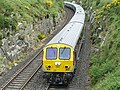
Transport
_-_geograph.org.uk_-_195736.jpg)

County Armagh is traversed by two major highways – the M1 linking Belfast to Dungannon crosses the north of the county whilst the A1/N1 from Belfast to Dublin runs in the far south east. Other major roads in the county include the A3 and A29.
Armagh once had a well-developed railway network with connections to, among others, Armagh City, Culloville, Goraghwood, Markethill, Vernersbridge, Tynan (see History of rail transport in Ireland ) but today only Newry (Bessbrook), Portadown, Poyntzpass, Scarva, and Lurgan are served by rail.
There is a possible railway re-opening from
Ulsterbus provides the most extensive public transport system within the county, including frequent bus transfers daily from most towns to Belfast.
Inland waterways
County Armagh is traversed by the Ulster Canal and the Newry Canal which are not fully open to navigation.
Sport
In association football, the NIFL Premiership, which operates as the top division, has one team in the county: Glenavon, with Portadown, Annagh United, Armagh City, Dollingstown, Loughgall and Lurgan Celtic competing in the NIFL Championship, which operates as levels two and three.
The Armagh County Board of the Gaelic Athletic Association or Armagh GAA organises Gaelic games in the county.
People associated with County Armagh
- Irish Republican, Irish Minister for External Affairs, Tánaiste
- Saint Benignus of Armagh, (died 467), first rector of the Cathedral School of Armagh and Bishop of Armagh
- Brian Boru (941–1014), buried in Armagh City, victor of Clontarf, High King of Ireland
- George Buchanan Armstrong (1822–1871), born in County Armagh, developed new system of sorting mail on trains in the United States[29]
- Sir Imperial Maritime Customs Service(IMCS) from 1863 to 1911
- Arthur Hunter Palmer (1819–1898), born in County Armagh, 5th Premier of Queensland
- Samuel Knox (1756–1832), born in County Armagh, Presbyterian clergyman, school principal, and author.[30]
- Tommy Makem (1932–2007), born in County Armagh, singer, musician, and songwriter, often called "The Bard of Armagh".
- deputy First Minister of Northern Ireland
- John McCreesh, American politician who served in the Pennsylvania State Senate from 1935 to 1958 was born in Armagh County in 1881.[31]
- Colin Morgan (1986– ), born in County Armagh, actor
- Paul Muldoon (1951– ), born in County Armagh, poet, winner of the Pulitzer Prize for Poetry and the T. S. Eliot Prize
- Primate of All Ireland1977–90
- Eunan O'Neill (1982), born in County Armagh, journalist, Russia Today
- Sir William Olpherts (1822–1902), born in County Armagh, soldier and recipient of the Victoria Cross
- First Minister of Northern Ireland
- Saint Patrick (fifth century), first Bishop of Armagh
- George William Russell 'Æ' (1867–1919), born in County Armagh, author, critic and painter
- Foreign Secretary, Secretary for War, Leader of the United Kingdom House of Commons and Chief Secretary for Ireland
- 2009 British Touring Car champion.
- Primate of All Ireland1625–1656
- politicianand author.
- Governor General of India
- Andrew Nesbitt (1960), raised in Aughnagurgan, County Armagh, professional rally driver and winner of the 2000 and 2002 Irish Tarmac Rally Championship. Considered one of Irelands top 5 ever drivers.
Places of interest
- Armagh Observatory, founded in 1790 & Armagh Planetarium, a modern working astronomical research institute with a rich heritage
- Armagh Public Library on Abbey Street in Armagh City, especially rich in 17th and 18th century English books, including Dean Jonathan Swift's own copy of the first edition of his Gulliver's Travels with his manuscript corrections
- Navan Fort, now a tree ring mound which once housed the rulers of Ulster with a modern interactive visitor centre
- Saint Patrick's Church of Ireland Cathedral, founded 445, seat of the Church of Ireland's Archbishop of Armagh, Primate of All Ireland, containing the grave of Brian Boru
- Saint Patrick's Roman Catholic Cathedral, commenced in 1838, seat of the Roman Catholic Archbishop of Armagh, Primate of All Ireland, stands on a hill and dominates the local countryside
- Gosford Castle, mock medieval 19th-century castle with substantial grounds
- Slieve Gullion, extinct volcano with crater lake, highest burial cairn in Ireland, views of 9 counties, a Mass rock, and a visitor centre at its foot
Gallery
-
 View of Slieve Gullion
 -
 The Enterprise near Newry
 -
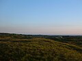 South Armagh Countryside
 -
 Forkhill Mountain
 -
 Emain Macha
 -
 Moyry Castle
 -
 Killnasaggart Stone, 700 A.D.
 -
 St. Patrick's Anglican Cathedral, est. 445
 -
 Armagh City
 -
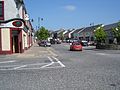 The small town of Markethill
 -
 Clare Glen Forest, Tandragee
 -
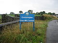 Approach to Crossmaglen
 -
 The Knock Bridge near Portadown on the Newry Canal
 -
 Gosford Castle, outside of Markethill


_-_geograph.org.uk_-_1590572.jpg)


See also
- Abbeys and priories in Northern Ireland (County Armagh)
- List of Irish counties by area
- List of Irish counties by population
- Lord Lieutenant of Armagh
- High Sheriff of Armagh
References
- ^ Northern Ireland General Register Office (1975). "Table 1: Area, Buildings for Habitation and Population, 1971". Census of Population 1971; Summary Tables (PDF). Belfast: HMSO. p. 1. Archived (PDF) from the original on 23 July 2019. Retrieved 28 August 2019.
- ^ Census figures are no longer released detailing returns for Counties but rather Parliamentary Constituency, Local Government District, Electoral Ward and Output Area. This figure is based on a tally of all persons resident in the wards comprising County Armagh on 29 April 2001, i.e. all electoral wards of the Newry & Armagh Parliamentary Constituency (minus St. Mary's, St. Patrick's and Windsor Hill from County Down) combined with the 17 wards in the Upper Bann Parliamentary Constituency from County Armagh (i.e. Derrytrasna, Birches, Bleary, Drumgask, Taghnevan, Court, Annagh, Brownstown, Ballybay, Ballyoran, Corcrain, Edenderry, Killycomain, Kernan, Drumgor, Mourneview, Church, Knocknashane, Parklane, Woodville, Drumnamoe, and Tavanagh). "Area Profiles". Northern Ireland Neighbourhood Information Service. Archived from the original on 7 January 2019. Retrieved 8 August 2008.
- ^ Tourism Ireland: 2007 Yearly Report in Ulster Scots Archived 17 July 2012 at the Wayback Machine
- ^ North-South Ministerial Council: 2006 Annual Report in Ulster Scots Archived 27 February 2013 at the Wayback Machine
- ^ a b c d e f g h i "Build or find Census 2021 tables | NISRA Flexible Table Builder". build.nisra.gov.uk. Retrieved 18 July 2023.
- ^ "Your Place And Mine – Armagh -". www.bbc.co.uk. Archived from the original on 16 October 2015. Retrieved 15 March 2018.
- ^ "NI temperature record broken for third time in a week". BBC News. British Broadcasting Corporation. 22 July 2021. Archived from the original on 22 July 2021. Retrieved 22 July 2021.
- ^ "Met Office". Retrieved 4 October 2008.[dead link]
- ^ For 1653 and 1659 figures from Civil Survey Census of those years, Paper of Mr Hardinge to Royal Irish Academy 14 March 1865.
- ^ Census for post 1821 figures. Archived 9 March 2005 at the Wayback Machine
- ^ "Histpop – The Online Historical Population Reports Website". www.histpop.org. Archived from the original on 7 May 2016.
- ^ NISRA – Northern Ireland Statistics and Research Agency (c) 2013 Archived 17 February 2012 at the Wayback Machine. Nisranew.nisra.gov.uk (27 September 2010). Retrieved on 23 July 2013.
- ^ Lee, JJ (1981). "On the accuracy of the Pre-famine Irish censuses". In Goldstrom, J. M.; Clarkson, L. A. (eds.). Irish Population, Economy, and Society: Essays in Honour of the Late K. H. Connell. Oxford, England: Clarendon Press.
- hdl:10197/1406. Archived from the originalon 4 December 2012.
- ^ Tony Nugent (2013), Were You at the Rock? The History of Mass Rocks in Ireland, Liffey Press, Dublin. Pages 32–39.
- ^ "Myth of Bandit Country". Armagh: Iarchimi Ard Mhacha Theas. 16 May 2014. Archived from the original on 17 May 2014. Retrieved 16 May 2014.
- ISBN 978-1-626-36987-0.
- ^ "Continuity IRA shot dead officer". BBC News. London. 10 March 2009. Archived from the original on 13 April 2021. Retrieved 10 March 2009.
- RTÉ News and Current Affairs. 10 March 2009. Archived from the originalon 11 March 2009. Retrieved 10 March 2009.
- ^ "Local Government Act (Northern Ireland) 1972". Legislation.gov.uk. Archived from the original on 30 October 2019. Retrieved 29 November 2019.
- ^ See the Northern Ireland (Lieutenancy) Order 1975 (SI 1975 No. 156)
- ^ "National identity (person based) - basic detail (classification 1)". NISRA. Retrieved 18 August 2023.
- ^ "National Identity (Irish)". NISRA. Retrieved 18 August 2023.
- ^ "National Identity (British)". NISRA. Retrieved 18 August 2023.
- ^ "National Identity (Northern Irish)". NISRA. Retrieved 18 August 2023.
- ^ a b c d e f "Statistical classification of settlements". NI Neighbourhood Information Service. Archived from the original on 17 February 2010. Retrieved 23 February 2009.
- ^ The Ulster Gazette. 16 May 2013
- ^ "Kennedy has hopes for Armagh line restoration – Portadown Times". Archived from the original on 21 August 2013. Retrieved 21 August 2013.
- ^ Who Was Who in America, Historical Volume, 1607–1896. Marquis Who's Who. 1963.
- ^ Ibid.
- ^ "Pennsylvania State Senate – John J McCreesh Biography". www.legis.state.pa.us. Retrieved 8 February 2019.
External links
- County Armagh at Curlie
- County Armagh on the interactive map of the counties of Great Britain and Ireland – Wikishire
- Armagh and Down tourism
- Armagh history
- Notes on County Armagh
- Selected Monuments in County Armagh
- South Armagh – The Myth of Bandit Country
Places adjacent to County Armagh | ||||||||||||||||
|---|---|---|---|---|---|---|---|---|---|---|---|---|---|---|---|---|
| ||||||||||||||||