
Curonian Spit
| UNESCO World Heritage Site | |
|---|---|
 The Valley of Death looking from the Parnidis Dune in Neringa Municipality, Lithuania in October 2022. | |
| Location | Klaipėda County, Lithuania Zelenogradsky District, Kaliningrad Oblast, Russia |
| Criteria | Cultural: v |
| Reference | 994 |
| Inscription | 2000 (24th Session) |
| Area | 33,021 ha |
| Coordinates | 55°16′28″N 20°58′15″E / 55.27444°N 20.97083°E |
 Location of the Curonian Spit on the Baltic Sea coast of Northern Europe  Curonian Spit (Kaliningrad Oblast)  Curonian Spit (Lithuania) | |
The Curonian (Courish) Spit (
Geography

The Curonian Spit stretches from the Sambia Peninsula on the south to its northern tip next to a narrow strait, across which is the port city of Klaipėda on the Lithuanian mainland. The northern 52 km (32 mi) long stretch of the Curonian Spit peninsula lies in Klaipėda County, Lithuania, while the rest is part of Russia's Kaliningrad Oblast, Russia. The width of the spit varies from a minimum of 400 m (1,300 ft) in Russia (near the village of Lesnoy) to a maximum of 3,800 m (12,500 ft; 2.4 mi) in Lithuania (just north of Nida).
Geologic history
The Curonian Spit was formed about 3rd millennium BC.[1] A glacial moraine served as its foundation; winds and sea currents later contributed enough sand to raise and keep the formation above sea level.[1]
The existence of this narrow shoal is inherently threatened by the natural processes that govern shoreline features.[2] It depends on a dynamic balance between sand transport and deposition. It is, geologically speaking, an ephemeral coast element. The most likely development is that the shallow bay inside the Curonian Spit will eventually fill up with sediment, thus creating new land.
Human history
Mythology
According to folk etymology for the name of Neringa Municipality, there was a giantess girl named Neringa, who formed the Curonian Spit and helped fishermen.[3]
Medieval period
From c. 800 to 1016, the Spit was the location of
Kursenieki habitation

Significant human impacts on the area began in the 16th century.
In the 19th century the Curonian Spit was inhabited primarily by Kursenieki, with a significant German minority in the south and a Lithuanian minority in the north. The population of Kursenieki eventually dwindled due to assimilation and other reasons; it is close to non-existent these days.[citation needed]
Artists' colony

From the late 19th century, the dune landscape around Nidden (
20th century

From 1901 to 1946 the village of Rossitten, now Rybachy, became the site of the Rossitten Bird Observatory, founded by German ornithologist Johannes Thienemann there because of the Spit's importance as a bird migration corridor.
After
In 1929
Following World War II, the German-occupied Lithuanian part of the spit was restored to Lithuania, while the remainder fell to Russia. The German population was expelled after the war by the occupying Soviet forces in accordance with the Potsdam Agreement. Like elsewhere in present-day Kaliningrad Oblast, the assimilation of the territory and colonization by Russian settlers was completed by changing the historic German toponyms to Russian ones throughout the Russian-controlled part of the Spit.
Today
After the breakup of the Soviet Union, tourism flourished; many Germans, mostly the descendants of the inhabitants of the area, choose the Curonian Spit (especially Nida, as no visas are needed for Germans in Lithuania) as their holiday destination. In 2019 the making of
Kursenieki
While today the Kursenieki, also known as Kuršininkai, are a nearly extinct Baltic ethnic group living along the Curonian Spit, in 1649 Kuršininkai settlement spanned from Memel (Klaipėda) to Gdańsk. The Kuršininkai were eventually assimilated by the Germans, except along the Curonian Spit where some still live. The Kuršininkai were considered Latvians until after World War I, when Latvia gained independence from the Russian Empire, a consideration based on linguistic arguments. This was the rationale for Latvian claims over the Curonian Spit, Memel and other territories of Prussia, which would be later dropped.
-
 Curonian pennant, Nida
 -
 Krikštas burial marker
 -
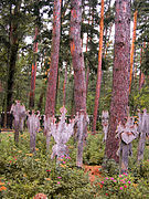 Old cemetery in Nida
 -
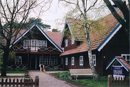 Small inn and cafe in Nida
 -
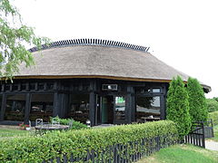 Fish restaurant in Nida
.JPG)


.jpg)
Current state


.jpg)
The Curonian Spit is home to the highest moving (drifting) sand dunes in Europe. Their average height is 35 metres (115 ft), but some attain a height of 60 metres (200 ft). Several
Both the Russian and Lithuanian parts of the spit are national parks.
The settlements of the Curonian Spit (from north to south) are:
The first six are on the Lithuanian side, while the last three are on the Russian side. The Russian side of the Curonian Spit belongs to
There is a single road that traverses the whole length of the Curonian Spit. Car ferries provide a transportation link between Smiltynė, located on the spit, and the port town of Klaipėda.
Since 2000, the Curonian Spit has been on
As of March 2012, there was a demand to tear down a number of homes on the Curonian Spit. These homes are owned by people who were given permits to build by corrupt local government[specify] officials. The demand to tear the homes down is based on the fact that the Spit is a UN World Heritage Site and the only structures that were to be allowed outside official settlements were fishing shacks.[8]
Tourism

The largest town on the spit is Nida in Lithuania, a holiday resort, mostly frequented by Lithuanian and German tourists.
Parnidis dune and sundial
Parnidis sand dune, subjected to drift by harsh winds, is rising up to 52 metres (171 ft) above sea level. Local residents believe that the name Parnidis comes from the phrase meaning "passed across Nida", because this wind-blown dune has several times passed through the village of Nida. Scientists estimated that each person climbing or descending on the steep dune slopes moves several tons of sand, so hikers are allowed to climb only in designated paths.
There is a granite sundial built on Parnidis dune in 1995 that accurately shows the time. The sundial was rebuilt in 2011 following storm damage. The sundial is a stone pillar 13.8 metres (45 ft) high and weighing 36 tonnes (35 long tons; 40 short tons). It consists in small steps covered with granite slabs, carved with hour and half-hour notches, as well as one notch for each month, and four additional notches for solstices and equinoxes. From the astronomical point of view Parnidis dune is an ideal place for the sundial in Lithuania.[9]
Environmental concerns

There are environmental concerns related to the Curonian Spit, which is often promoted as a refuge of clean nature.
Due to the importance of tourism and fishing for the regional economy, pollution of sea and coastlines may have disastrous effects for the area as the unique nature and the economy would be damaged.
.jpg)
The construction of an offshore drilling facility (the
Another concern is that increased tourism destroys the very nature that attracts it. For this reason, protective measures have been taken, such as banning tourists from hiking in certain areas of the spit.
Natural hazards are more dangerous in the Curonian Spit than elsewhere in Lithuania or the Kaliningrad Oblast. For example, storms tend to be stronger there. Due to the importance of trees in preventing soil erosion, forest fires that happen in summer are more dangerous to the ecology.
See also
- Kuršių Nerija National Park
- Curonian Spit National Park (Russia)
- Vecekrugas dune
- Vistula Spit
References
- ^ Kuršių Nerija National Park. Archivedfrom the original on 2012-05-30. Retrieved 2021-03-28.
- ^ "Curonian Spit". UNESCO. Retrieved 2010-06-15.
- ISBN 5430047694 (online)
- ISBN 978-0-7425-1705-9. Retrieved 2019-08-20.
- ^ a b Weise, p. 159
- ^ "The making of Curonian Lagoon boats' weathervanes". savadas.lnkc.lt. Lithuanian National Culture Centre. Retrieved May 5, 2023.
- ^ a b "Curonian Spit" (PDF). UNESCO. Archived from the original (PDF) on 2011-07-22. Retrieved 2010-06-15.
- ^ "Lithuania:The Battle for the Curonian Spit". Deutsche Welle. Retrieved 2012-10-03.
- ^ "Parnidis Dune with Sun Clock – Calendar". Lithuania.travel. Archived from the original on 2016-03-24. Retrieved 2016-04-25.
- ^ [1] Archived October 9, 2007, at the Wayback Machine
- ^ [2] Archived January 11, 2006, at the Wayback Machine
- ^ a b "32COM 7B.98 – Curonian Spit (Lithuania / Russian Federation) (C 994)". UNESCO World Heritage Committee. Retrieved 2010-06-15.
External links
- UNESCO World Heritage Site Curonian Spit
- Kursiu Nerija National Park (in Lithuania) Archived 2015-05-14 at the Wayback Machine
- National Park Kurshskaya Kosa (in Russia)
- Rybachy Biological Station, Russian Academy of Sciences
- Curonian Spit at Natural Heritage Protection Fund
| ||
| International | |
|---|---|
| National | |