
Cuxhaven
This article needs additional citations for verification. (January 2013) |
Cuxhaven
Cuxhoben ( Low German) | |
|---|---|
 , symbol of Cuxhaven , symbol of Cuxhaven | |
 Coat of arms | |
Location of Cuxhaven within Cuxhaven district 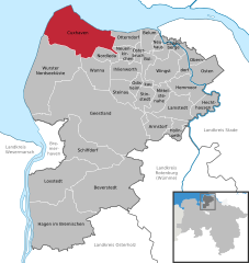 | |
 Cuxhaven  Cuxhaven | |
| Coordinates: 53°51′40″N 08°41′40″E / 53.86111°N 8.69444°E | |
| Country | Germany |
| State | Lower Saxony |
| District | Cuxhaven |
| Government | |
| • Lord mayor (2019–24) | Uwe Santjer[1] (SPD) |
| Area | |
| • Total | 161.91 km2 (62.51 sq mi) |
| Elevation | 2 m (7 ft) |
| Population (2021-12-31)[2] | |
| • Total | 48,318 |
| • Density | 300/km2 (770/sq mi) |
| Time zone | UTC+01:00 (CET) |
| • Summer (DST) | UTC+02:00 (CEST) |
| Postal codes | 27472, 27474, 27476, 27478 |
| Dialling codes | 04721-04724 |
| Vehicle registration | CUX |
| Website | www.cuxhaven.de |
Cuxhaven (German:
Cuxhaven is home to an important fisherman's wharf and ship registration point for Hamburg as well as the Kiel Canal until 2008. Tourism is also of great importance. The city and its precursor Ritzebüttel belonged to Hamburg from the 13th century until 1937. The island of Neuwerk, a Hamburg dependency, is located just northwest of Cuxhaven in the North Sea. The city's symbol, known as the Kugelbake, is a beacon once used as a lighthouse; the wooden landmark on the mouth of the Elbe marks the boundary between the river and the North Sea and also adorns the city's coat of arms.
History

Ritzebüttel, today a part of Cuxhaven, belonged to the
The Hamburg America Line built a large ocean liner terminal at Cuxhaven in 1900. Connected directly to Hamburg by a dedicated railway line and station, it served as the major departure point for German and European emigrants until 1969 when ocean liner travel ceased. The ornate assembly hall and associated buildings survived wartime damage and peacetime urban renewal to be restored in 1998 for use as a museum and cruise ship terminal.[4]
On 15 March 1907 Cuxhaven gained city status within the state of Hamburg. In 1937 Cuxhaven became an urban district of the Stade Region within the Prussian Province of Hanover by the Greater Hamburg Act. In 1972 some municipalities of the neighboured rural district of Land of Hadeln were incorporated into the urban district of Cuxhaven. In 1977 Cuxhaven lost the status as urban district and was integrated into the new rural District of Cuxhaven, being its capital.
During the
During the
Between 1945 and 1964 the Hermann-Oberth-Gesellschaft performed various civilian experiments in rocketry near Cuxhaven.
Tourism


The origins of tourism go back to the year 1816 when a seaside resort was founded in Cuxhaven. Since 1964 Cuxhaven has been a state-recognized climate seaside resort (Seeheilbad) and centre of the so-called holiday region of Cuxland.
Geographical and cultural background
The town is served by Cuxhaven station.
The island of Neuwerk is situated 8 kilometres (5 mi) off the coast from Cuxhaven. At low tide the water recedes so far from the coast that the island can be reached either by mudflat hiking or by horse carriage.
A modern landmark of Cuxhaven is the
The
Twin towns – sister cities
 Binz, Germany (1990)
 Hafnarfjörður, Iceland (1988)
 Penzance, England, United Kingdom (1967–1974, 2009–present)
- Sassnitz, Germany (1990)
 Vannes, France (1963)
Notable people

- Carsten Niebuhr (1733–1815), mathematician, cartographer and explorer.[8]
- Joachim Ringelnatz (1883–1934), poet, cabaret artiste and painter. Since 2002 the city hosts the Joachim Ringelnatz-Museum, managed by the Joachim Ringelnatz-Foundation.
- Francis Dutton CMG (1818–1877), 7th Premier of South Australia
- Anna Strohsahl (1885–1953), first woman city councillor in Cuxhaven
- Curt Rothenberger (1896–1959), lawyer and Nazi politician
- August Dieckmann (1912–1943), Knight's Cross of the Iron Cross recipient
- Rainer Feist (1945–2007), Admiral, Deputy Supreme Commander of the NATO – HQ
- Stefanie Schneider (born 1968), photographer/artist
- Volker Neumüller (born 1969), music manager and former DSDS jury member
- Constantin Schreiber (born 1979), journalist and author
Sport
- Jochen Fraatz (born 1963), handball player, member of the national team, team silver medallist at the 1984 Summer Olympics
- Gunnar Sauer (born 1964), footballer, played 303 games
- Lena Petermann (born 1994), footballer, played over 170 games and 22 for Germany women's national football team
Climate
Cuxhaven has an oceanic climate (Köppen: Cfb).
| Climate data for Cuxhaven (1991–2020 normals, extremes 1946–present) | |||||||||||||
|---|---|---|---|---|---|---|---|---|---|---|---|---|---|
| Month | Jan | Feb | Mar | Apr | May | Jun | Jul | Aug | Sep | Oct | Nov | Dec | Year |
| Record high °C (°F) | 14.4 (57.9) |
17.5 (63.5) |
22.4 (72.3) |
28.0 (82.4) |
31.3 (88.3) |
33.8 (92.8) |
35.9 (96.6) |
36.3 (97.3) |
31.4 (88.5) |
25.6 (78.1) |
19.4 (66.9) |
14.5 (58.1) |
36.3 (97.3) |
| Mean daily maximum °C (°F) | 4.5 (40.1) |
4.9 (40.8) |
7.8 (46.0) |
12.3 (54.1) |
16.1 (61.0) |
19.0 (66.2) |
21.4 (70.5) |
21.6 (70.9) |
18.2 (64.8) |
13.5 (56.3) |
8.5 (47.3) |
5.5 (41.9) |
12.8 (55.0) |
| Daily mean °C (°F) | 2.7 (36.9) |
2.9 (37.2) |
5.0 (41.0) |
8.8 (47.8) |
12.6 (54.7) |
15.7 (60.3) |
18.0 (64.4) |
18.2 (64.8) |
15.1 (59.2) |
10.9 (51.6) |
6.5 (43.7) |
3.6 (38.5) |
10.0 (50.0) |
| Mean daily minimum °C (°F) | 0.7 (33.3) |
0.8 (33.4) |
2.5 (36.5) |
5.8 (42.4) |
9.6 (49.3) |
12.7 (54.9) |
15.1 (59.2) |
15.2 (59.4) |
12.4 (54.3) |
8.4 (47.1) |
4.5 (40.1) |
1.7 (35.1) |
7.4 (45.3) |
| Record low °C (°F) | −15.7 (3.7) |
−18.2 (−0.8) |
−13.3 (8.1) |
−2.6 (27.3) |
0.5 (32.9) |
4.2 (39.6) |
7.2 (45.0) |
7.6 (45.7) |
3.3 (37.9) |
−2.4 (27.7) |
−7.9 (17.8) |
−15.1 (4.8) |
−18.2 (−0.8) |
| Average precipitation mm (inches) | 69.1 (2.72) |
53.1 (2.09) |
48.4 (1.91) |
36.8 (1.45) |
52.1 (2.05) |
77.1 (3.04) |
84.8 (3.34) |
90.6 (3.57) |
80.8 (3.18) |
84.2 (3.31) |
71.5 (2.81) |
77.8 (3.06) |
824.4 (32.46) |
| Average precipitation days (≥ 0.1 mm) | 18.6 | 15.6 | 15.5 | 13.1 | 13.7 | 15.0 | 16.1 | 16.8 | 15.9 | 17.7 | 18.9 | 19.0 | 193.6 |
| Average snowy days (≥ 1.0 cm) | 3.6 | 4.3 | 1.9 | 0.1 | 0 | 0 | 0 | 0 | 0 | 0 | 0.4 | 3.0 | 15.0 |
| Average relative humidity (%)
|
86.9 | 84.4 | 81.2 | 76.7 | 75.2 | 75.4 | 75.9 | 75.8 | 78.5 | 82.3 | 86.5 | 87.9 | 80.5 |
| Mean monthly sunshine hours | 47.3 | 71.7 | 131.4 | 192.5 | 233.1 | 218.1 | 229.8 | 211.3 | 157.3 | 108.8 | 53.6 | 37.3 | 1,698.5 |
| Source 1: NOAA[9]
| |||||||||||||
| Source 2: DWD (extremes)[10] | |||||||||||||
See also
- Rocket experiments in the area of Cuxhaven
- Operation Backfire
References
- Landesamt für Statistik Niedersachsen. April 2021.
- Landesamt für Statistik Niedersachsen.
- ^ Chisholm, Hugh, ed. (1911). . Encyclopædia Britannica. Vol. 7 (11th ed.). Cambridge University Press. p. 677.
- ^ "Hapag Halle Museum Cuxhaven". Archived from the original on 2016-03-04. Retrieved 2014-10-15.
- )
- ^ Corera, Gordon (8 May 2020). "VE Day 2020: Last Nazi message intercepted by Bletchley Park revealed". BBC News. Retrieved May 13, 2020.
- ^ "Städte". cuxhaven.de (in German). Cuxhaven. Archived from the original on 2021-01-15. Retrieved 2021-02-11.
- ^ . Encyclopædia Britannica. Vol. XVII (9th ed.). 1884.
- ^ "Cuxhaven Climate Normals 1991–2020". National Oceanic and Atmospheric Administration. Archived from the original on 16 September 2023. Retrieved 16 September 2023.
- ^ "Extremwertanalyse der DWD-Stationen, Tagesmaxima, Dekadenrekorde, usw" (in German). DWD. Retrieved 29 June 2022.
External links
- Official site (in German)
- Operation "Backfire" and rocket experiments at Cuxhaven (in German)
- Further Tourist Information
Places adjacent to Cuxhaven | ||||||||||||||||
|---|---|---|---|---|---|---|---|---|---|---|---|---|---|---|---|---|
| ||||||||||||||||
Towns and municipalities in Cuxhaven (district) | ||
|---|---|---|
 | ||
| International | |
|---|---|
| National | |
| Geographic | |
| Other | |