Deûle
| Deûle | |
|---|---|
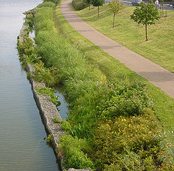
 The Deûle near Bois Blancs | |
 | |
| Location | |
| Country | France |
| Region | Hauts-de-France |
| Physical characteristics | |
| Source | |
| • location | France |
Lys | |
• coordinates | 50°43′52″N 2°56′41″E / 50.73111°N 2.94472°E |
| Basin features | |
| Progression | Lys→ Scheldt→ North Sea |
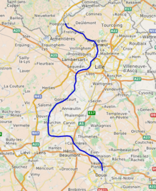
The Deûle (French pronunciation: Lys (right bank) in Deûlémont.
The Souchez is formed from the union, in the village of Souchez, of two smaller brooks, called the Carency and the Saint-Nazaire.
The channeled part comprises two branches:
- the high gauge
- the Canal de Lens,[2] fed by the Souchez,[3] which connects Lens with the Canal de la Deûle at Courrières.
Immediately downstream of Lens, the channel is unusually elevated compared to the neighboring banks, as a result of mining depressions.
The Deûle flows through the departments of Pas-de-Calais and Nord, and the towns of Lens, Wingles, Loos, Lille, Wambrechies and Quesnoy-sur-Deûle, before it flows into the Lys at Deûlémont.
The Deûle does not yet profit from a Schéma d'aménagement et de gestion des eaux.

References
External links
Wikimedia Commons has media related to Deûle.
- https://web.archive.org/web/20030910115632/http://www.eau-artois-picardie.fr/edition/magazine/cc30/etude.htm (in French)


