
Deir Yassin
Deir Yassin
دير ياسين Dayr Yasin | |
|---|---|
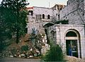
.jpg) Deir Yassin today, part of the Kfar Shaul Mental Health Center | |
| Etymology: "Monastery of [Sheikh] Yassin"[1] | |
.jpg) 1870s map 1870s map .jpg) 1940s map 1940s map.jpg) modern map modern map .jpg) 1940s with modern overlay map 1940s with modern overlay mapA series of historical maps of the area around Deir Yassin (click the buttons) | |

Deir Yassin (
Name
The first part of the village's name Deir is defined as "monastery" in
History
Crusader/Ayyubid and Mamluk periods
Deir Yassin has been identified as one of the villages given as a
Tawfiq Canaan noted that a yellow stone, popular in the Jerusalem Mamluk ablaq building decorations, was apparently quarried at Deir Yassin towards the end of the fifteenth century.[9]
Ottoman period
During the

It is unknown precisely when settlement shifted to Deir Yassin. The village was named in honor of a certain Sheikh Yassin whose tomb was in a mosque, or shrine located just outside the village,[4] on a high spot, dominating the surrounding area.[12] The village guesthouse, or Madafeh, was located opposite the shrine.[13]
Edward Robinson noted the village in 1838,[14] and by 1870, an Ottoman village list indicated 13 houses and a population of 48, though the list only counted men.[15][16] In 1896 the population of Deir Yassin was estimated to be about 138 persons.[17]
In the late 19th century, the houses of Deir Yassin were built of stone. Two springs—one located in the north and another in the south—supplied water to the village.
World War I and British Mandate

During
Deir Yassin's inhabitants prospered from mining, its main source of employment. A rich vein of hard yellow limestone, known as mizi yahudi was prized for its resistance to the rigors of Jerusalem's climate. The quarry (hajar yasinik or "Yasin's stone") supplied the Jerusalem market, and the wealth allowed the village to develop spacious housing, two elementary schools and mosques.[19] By the late 1940s, there were four stone crushers functioning in the village. The business encouraged the wealthier inhabitants to invest in trucking while others became truck drivers. In 1935, a local bus company was established in a joint venture with the neighboring Arab village of Lifta. As Deir Yassin prospered, houses radiated from the Hara uphill and eastward, towards Jerusalem.[4]

In the early days of the British Mandate, Deir Yassin had no school of its own and its children attended the school at Lifta or in Qalunya. By 1943, two elementary schools were built—one for boys and one for girls. The girls' school had a resident headmistress from Jerusalem. At that time, Deir Yassin also had a bakery, two guesthouses, and a social club—the "Renaissance Club", a thrift fund, three shops, four wells and a second mosque built by Mahmud Salah, an affluent resident. Many inhabitants were employed outside the village in the nearby British Army camps as waiters, carpenters, and foremen; others as clerks and teachers in the mandatory civil service. By this time, no more than 15% of the population was engaged in agriculture.[20]
Relations between Deir Yassin and its Jewish neighbors had started reasonably well under the Ottomans, particularly early on when Arabic-speaking
April 1948
.jpg)
When hostilities erupted in 1948, the villagers of Deir Yassin and those of the nearby Jewish village of
On April 10, 1948, one day after the Deir Yassin massacre, Albert Einstein wrote a critical letter to the American Friends of Fighters for the Freedom of Israel (the U.S chapter of Lehi) refusing to assist them with aid or support to raise money for their cause in Palestine.[24][25] On December 2, 1948, many prominent American Jews signed and published an op-ed article in The New York Times critical of Menachem Begin and the massacre at Deir Yassin.[26]
Post-1948
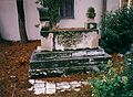
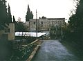
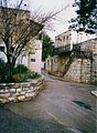
Following the war, the area was incorporated into the State of Israel. A year later, the Jewish neighborhood of Givat Shaul Bet was built on Deir Yassin's land, despite Israeli scholars' protests to Prime Minister David Ben-Gurion.[27] In 1951, the Kfar Shaul Mental Health Center was built within the village itself, using some abandoned village buildings themselves.[28] In 1980, the remaining ruins of the village were bulldozed to clear the ground for new Orthodox Jewish neighborhoods. In the early 1980s, most of the Deir Yassin cemetery was bulldozed and a new highway to Givat Shaul Bet was paved in its place.

In 1992,
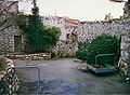
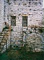
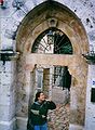
Many of the village houses on the hill are still standing and have been incorporated into an Israeli hospital for the mentally ill that was established on the site. Some houses outside the fence of the hospital grounds are used for residential and commercial purposes, or as warehouses. Outside the fence, there are carob and almond trees and the stumps of olive trees. Several wells are located at the southwestern edge of the site. The old village cemetery, southeast of the site, is unkempt and threatened by debris from a ring road that has been constructed around the village hill. One tall cypress tree still stands at the center of the cemetery.[29]
The killings at Deir Yassin are regarded as one of two pivotal events that led to the
Geography

Deir Yassin was built on the eastern slopes of a hill, with an elevation of roughly 800 meters (2,600 ft) above sea level and commanding a wide view all around it. The village faced the western suburbs of Jerusalem which were 1 kilometer (0.62 mi) away. The city center of Jerusalem was about 5 kilometers (3.1 mi) to the east. It was separated from the city by a terraced valley planted with fig, almond, and olive orchards. Along the northern rim of the valley ran a secondary road linking Deir Yassin to the suburbs and to the main Jaffa Road which was about 2 kilometers (1.2 mi) to the north.[4]
The total land area of the village consisted of 2,857 dunams (286 hectares), of which 94.5% was Arab-owned, 5.3% was Jewish-owned and the remainder was public property.[31] Cultivable land amounted to a total of 866 dunams (30%) (87 hectares), all of which was grown with grains and owned mostly by Arabs.[32] The built-up area of the village was 12 dunams.[33]

Demographics
Khirbet Ayn al-Tut had a population of 39 in 1596, during early Ottoman rule.[4] In the 1922 British Mandate census, Deir Yassin had a population of 254.[34] Its population had increased from 429 in the 1931 census to 750 in 1948 and its houses from 91 in the former year to 144 in the latter.[20][35] Before its ravage in 1948, it is estimated that Deir Yassin had 610 Muslim inhabitants in the 1945 statistics.[31][2] The five hamulas (clans) of Deir Yassin were the Shahada, 'Aql, Hamidad, Jabir and Jundi.[36]
Gallery
-
 Village remains images by Daniel A. McGowan
 -
-
-

-
-

-
-
-
-
.jpg)
.jpg)
.jpg)
.jpg)
.jpg)
.jpg)
.jpg)
.jpg)
.jpg)
.jpg)
References
- ^ Palmer, 1881, p. 293
- ^ a b Government of Palestine, Department of Statistics, 1945, p. 24
- ^ Morris, 2004, p. xx, village #362. Also give causes of depopulation.
- ^ a b c d e f g h Khalidi, 1992, p.289.
- ^ Conder and Kitchener, 1883, SWP III, p. 21
- ^ Röhricht, 1893, #164, pp. 40-41
- ^ Delaville Le Roulx, 1894, vol I, p. 98; line 13: Irrasin is typo for Deirrasin according to Delaville Le Roulx, 1906, vol IV, p. 312, which is an alternative name for Deir Yassin; according to Delaville Le Roulx, 1906, vol IV, p. 449
- ^ Tobler, 1854, pp. 529 -530. Cited in Pringle, 1997, p. 47. The building was completely demolished in 1948.
- ^ Canaan, 1933, cited in Burgoyne, 1987, p. 41
- ^ Palmer, 1881, p. 301
- ^ Hütteroth and Abdulfattah, 1977, p. 113
- ^ Canaan, 1927, p. 4
- ^ Canaan, 1927, pp. 16, 287
- ^ Robinson and Smith, 1841, vol 2, p. 141.
- ^ Socin, 1879, p. 152
- ^ Hartmann, 1883, p. 118 also noted 13 houses
- ^ Schick, 1896, p. 125
- ^ Conder and Kitchener, 1883, III:21. Quoted in Khalidi, 1992, p. 289.
- ^ a b Benvenisti, 2000, p. 115.
- ^ a b c d Khalidi, 1992, p. 290.
- ^ Tessler, 1994, p. 292
- ^ Morris, 2004, footnote 564, p. 294; see Dr. Z Avigdori and Dr A. Druyan's "Report on Visit to Deir Yassin on 12.4.1948," April 18, 1948. Gelber 2006 Archived 2008-02-27 at the Wayback Machine, p. 314.
- ^ Khalidi, 1992, p.291.
- ^ Scanned copy of letter available at "Palestine Remembered: Deir Yassin".
- ISBN 978-0-312-36228-7.
- ^ "Wrestling With Zion: Re-thinking Jewish Tradition and the Ongoing Crisis in the Middle East".
- ^ Segev 1998, pp. 87-88. The source says: "By the summer of 1949, 5 acres of olive groves had already been ploughed over and 300 crates of plums had been marketed from the village orchards. The grape harvest began and a new settlement was well under way. The village was now given the name Givat Shaul Bet. In the past it had been known as Deir Yassin."
- ^ Moreno, 1959, p. 279.
- ^ Khalidi, 1992, p.292.
- ^ Morris, 2004, pp. 239–240.
- ^ a b Government of Palestine, Department of Statistics. Village Statistics, April, 1945. Quoted in Hadawi, 1970, p. 57.
- ^ Government of Palestine, Department of Statistics. Village Statistics, April, 1945. Quoted in Hadawi, 1970, p.102.
- ^ Government of Palestine, Department of Statistics. Village Statistics, April, 1945. Quoted in Hadawi, 1970, p. 152.
- ^ Barron, 1923, Table VII, Sub-district of Jerusalem, p. 15
- ^ Mills, 1932, p. 39
- ^ Kark and Oren-Nordheim, 2001, p. 228
Bibliography
- Barron, J.B., ed. (1923). Palestine: Report and General Abstracts of the Census of 1922. Government of Palestine.
- ISBN 0-520-21154-5.
- Burgoyne, Michael Hamilton (1987). Mamluk Jerusalem. British School of Archaeology in Jerusalem by the World of Islam Festival Trust. ISBN 090503533X.
- Canaan, T. (1927). Mohammedan Saints and Sanctuaries in Palestine. London: Luzac & Co.
- Canaan, T. (1933). The Palestine Arab House: Its Architecture and Folklore. Jerusalem: The Syrian Orphanage Press.
- Conder, C.R.; Kitchener, H.H. (1883). The Survey of Western Palestine: Memoirs of the Topography, Orography, Hydrography, and Archaeology. Vol. 3. London: Committee of the Palestine Exploration Fund.
- Delaville Le Roulx, J. [in French] (1894). Cartulaire général de l'Ordre des Hospitaliers (in Latin). Vol. 1. Paris.
{{cite book}}: CS1 maint: location missing publisher (link) - Delaville Le Roulx, J. [in French] (1906). Cartulaire général de l'Ordre des Hospitaliers (in Latin). Vol. 4. Paris.
{{cite book}}: CS1 maint: location missing publisher (link) - Government of Palestine, Department of Statistics (1945). Village Statistics, April, 1945.
- Hadawi, S. (1970). Village Statistics of 1945: A Classification of Land and Area ownership in Palestine. Palestine Liberation Organization Research Center.
- Hartmann, M. (1883). "Die Ortschaftenliste des Liwa Jerusalem in dem türkischen Staatskalender für Syrien auf das Jahr 1288 der Flucht (1871)". Zeitschrift des Deutschen Palästina-Vereins. 6: 102–149.
- Hütteroth, Wolf-Dieter; Abdulfattah, Kamal (1977). Historical Geography of Palestine, Transjordan and Southern Syria in the Late 16th Century. Erlanger Geographische Arbeiten, Sonderband 5. Erlangen, Germany: Vorstand der Fränkischen Geographischen Gesellschaft. ISBN 3-920405-41-2.
- ISBN 0-8143-2909-8.
- ISBN 0-88728-224-5.
- Mills, E., ed. (1932). Census of Palestine 1931. Population of Villages, Towns and Administrative Areas. Jerusalem: Government of Palestine.
- Moreno, J.L. (1959). Progress in Psychotherapy. Grune & Stratton.
- ISBN 978-0-521-00967-6.
- Palmer, E.H. (1881). The Survey of Western Palestine: Arabic and English Name Lists Collected During the Survey by Lieutenants Conder and Kitchener, R. E. Transliterated and Explained by E.H. Palmer. Committee of the Palestine Exploration Fund.
- ISBN 0521-46010-7.
- Robinson, E.; Smith, E. (1841). Biblical Researches in Palestine, Mount Sinai and Arabia Petraea: A Journal of Travels in the year 1838. Vol. 2. Boston: Crocker & Brewster.
- Röhricht, R. (1893). (RRH) Regesta regni Hierosolymitani (MXCVII-MCCXCI) (in Latin). Berlin: Libraria Academica Wageriana.
- Segev, T. (1998). 1949. The First Israelis. Owl Books by Henry Holt and Company.
- Schick, C. (1896). "Zur Einwohnerzahl des Bezirks Jerusalem". Zeitschrift des Deutschen Palästina-Vereins. 19: 120–127.
- Socin, A. (1879). "Alphabetisches Verzeichnis von Ortschaften des Paschalik Jerusalem". Zeitschrift des Deutschen Palästina-Vereins. 2: 135–163.
- Tessler, Mark A. (1994). A History of the Israeli-Palestinian Conflict. Indiana University Press. ISBN 0253208734.
- Tobler, T. (1854). Dr. Titus Toblers zwei Bucher Topographie von Jerusalem und seinen Umgebungen (in German). Vol. 2. Berlin: G. Reimer.
External links
- Welcome To Dayr Yasin
- Dayr Yasin, Zochrot
- Survey of Western Palestine, Map 17: IAA, Wikimedia commons
- Dayr Yasin Archived 2002-03-05 at the Wayback Machine, by Rami Nashashibi (1996), Center for Research and Documentation of Palestinian Society.

| International | |
|---|---|
| National | |