Dhrangadhra State
| Dhrangadhra Jhalavad | |||||||
|---|---|---|---|---|---|---|---|
| 1090–1949 | |||||||
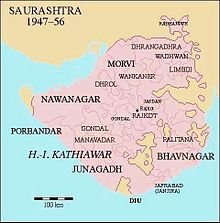
 Location of Dhragandhra State in Saurashtra | |||||||
| Capital | Dhrangadhra | ||||||
| Area | |||||||
• 1892 | 3,023 km2 (1,167 sq mi) | ||||||
| Population | |||||||
• 1892 | 100,000 | ||||||
| History | |||||||
• Established | 1090 | ||||||
| 1949 | |||||||
| |||||||
| Today part of | India | ||||||
| Princely States of India | |||||||
Dhrangadhra State (previously known as Jhalavad) was a princely state during the British Raj in India. The town of Dhrangadhra served as its capital. It was also known as Halvad-Dhrangadhra State. Halvad once had been the capital of this state.[1] In 1735, Dhrangadhra was founded as its new capital.
History


The state was founded as Jhalawad/Zalawad in 1090 by Rajput ruler
Jhala Rajput was the battle of Gadarghatta in 1178. Jhaleswar Raj Durjanshalji defeated Mohamad Ghuri and accepted the surrender of Muslim forces and Ghori. In 1742, Dhrangadhra, a new capital was founded and renamed the state. Among the earlier names were Kuwa and Halwad; the state is still sometimes styled Halwad(-Dhrangadhra).[citation needed
]
Under the British Raj, the colonial
Eastern Kathiawar Agency was in charge of Dhrangadhra, which was a salute state
entitled to a Hereditary salute of 13 guns.
The state had a population of 100,000 in 1892 on 3,023 Square Kilometers km2. The privy purse was fixed at 380,000 Rupees when it ceased to exist by accession to recently independent India's western state Saurashtra (now in Gujarat) on 15 February 1948.[citation needed
]
Orders of chivalry
The Royal House of Dhrangadhra awards a dynastic order of knighthood called the Order of Jhalavad, in six grades.[2]


