
Dibër County
Dibër County
Qarku i Dibrës (Albanian) | |
|---|---|
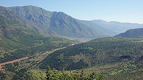
 Drin Valley | |
|
11th of 12 | |
| NUTS Code | AL011 |
| Website | Official Website |
Dibër County (Albanian pronunciation:
The county territory covers four distinct climatic types as of the Köppen climate classification; oceanic, continental, mediterranean and subarctic.[4] Located in the interior of Albania, the climate is mediterranean with continental influences.[5] Mean monthly temperature ranges between −20 °C (−4 °F) (in January) and 25–30 °C (77–86 °F) (in July). Mean annual precipitation ranges between 600 millimetres (24 inches) and 1,000 millimetres (39 inches) depending on geographic region and prevailing climate type.
Dibër is an historically homogeneous county. Its capital and most populous city is Peshkopi. Tourism is one of the most important sectors in the county and has the largest potential to be a source for sustainable income, due to its natural and cultural heritage. Although the county has abundant natural resources like chromium, sulfur and marble. Dibër is predominantly an agriculture county.
History

Human activity in the territory of the modern Dibër County can be traced back to the Neolithic.[6]
The region that today corresponds to the county territory was inhabited by the ancient
In the
In the 19th century, the
Geography


Dibër is one of 12 counties of Albania, located in the south and southeast of the Northern Region. It lies between latitudes 42° N, and longitudes 20° E. The county area is 2,586 km2 (998 sq mi) and the sixth largest by area in Albania and the second largest in the Northern Region. It is limited to the counties of Kukës to the north and northeast, Lezhë to the northwest, Durrës to the east, Tirana to the southwest, Elbasan to the southeast and North Macedonia to the west.
Much of the Dibër County is dominated by mountainous or high terrain, with a great variety of natural features caused by prehistoric
The most important rivers flowing through Dibër include the
Demography
It has a total population of around 113,683 people as of 2021.
Economy
Dibër County’s economy historically depended on agriculture and sheparding, although the collapse of communism and lack of jobs has led to many Albanians migrating abroad. Dibra is consequently one of the poorer regions of Albania due to its remote and rugged situation, although it is more developed than neighboring Elbasan and Kukës counties which have seen severe economic stagnation. Dibër County is the second least developed county in Albania with only Kukës being less developed. [1]
Gallery
-
 Dejë Mountain
 -
 Malthit e keq
 -
 Mali i Gramës
 -
 Gryka e Setës
 -
 Mount Korab
 -

.jpg)

.jpg)


See also
- Geography of Albania
- Politics of Albania
- Divisions of Albania
- List of mountains in Dibër County
References
- ^ a b "Population on 1st January by prefecture and sex" (PDF). INSTAT. 7 May 2021. p. 6.
- ^ "Law nr. 115/2014" (PDF) (in Albanian). p. 6367. Retrieved 25 February 2022.
- ^ "Strategjia e Territorit Bashkia Dibër" (PDF). km.dldp.al (in Albanian). p. 10.
- ^ University of Tirana. "TURIZMI NË RRETHIN E DIBRËS" (PDF). doktoratura.unitir.edu.al (in Albanian). pp. 24–27. Archived from the original (PDF) on 2017-10-08. Retrieved 2017-10-08.
- ^ "Strategjia e Territorit Bashkia Dibër" (PDF). km.dldp.al (in Albanian). p. 7.
- ^ a b University of Tirana. "TURIZMI NË RRETHIN E DIBRËS" (PDF). doktoratura.unitir.edu.al (in Albanian). p. 65. Archived from the original (PDF) on 2017-10-08. Retrieved 2017-10-08.
- ISBN 99943-625-8-5.
- ^ "ZONA FUNKSIONALE BURREL- KLOS PROGRAMI DLDP" (PDF). km.dldp.al (in Albanian). p. 3.
- ^ History of the Albanian people Archived 2016-08-10 at the Wayback Machine 2002 edition from the Academy of Sciences of Albania Tome I, p. 335
- ^ a b University of Tirana. "TURIZMI NË RRETHIN E DIBRËS" (PDF). doktoratura.unitir.edu.al. p. 21. Archived from the original (PDF) on 2017-10-08. Retrieved 2017-10-08.
- ^ European Green Belt. "Balkan Green Belt as Ecological Corridor for Wolf, Bear and Lynx". europeangreenbelt.org. Archived from the original on 2018-06-12. Retrieved 2018-12-29.
- ^ European Green Belt. "Brezi i Gjelbër Evropian" (PDF). europeangreenbelt.org (in Albanian). p. 2. Archived from the original (PDF) on 2015-10-18. Retrieved 2018-12-29.
- INSTAT. "Population and Housing Census" (PDF). instat.gov.al (in Albanian). p. 40. Archived from the original(PDF) on 2016-03-03. Retrieved 2015-05-25.
- INSTAT. "Population and Housing Census" (PDF). instat.gov.al (in Albanian). p. 39. Archived from the original(PDF) on 2016-03-03. Retrieved 2015-05-25.
- INSTAT. "Population and Housing Census" (PDF). instat.gov.al (in Albanian). p. 39. Archived from the original(PDF) on 2016-03-03. Retrieved 2015-05-25.
| ||||||||||||||

| Authority control databases: Geographic |
|---|