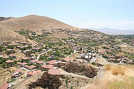
Divriği
Divriği | |
|---|---|
 | |
| Coordinates: 39°22′N 38°07′E / 39.367°N 38.117°E | |
| Country | Turkey |
| Province | Sivas |
| District | Divriği |
| Government | |
| • Mayor | Hakan Gök (CHP) |
| Population (2022)[1] | 10,800 |
| Time zone | UTC+3 (TRT) |
| Postal code | 58300 |
| Area code | 0346 |
| Website | www |
Divriği, historically Tephrike (
World Heritage List by virtue of the exquisite carvings and architecture of both buildings.[3] Hakan Gök is the current mayor.[4]
History
Great Mosque and Hospital of Divriği
Middle Ages
Tephrike was recaptured by the Byzantine Empire during the reign of Emperor
Seneqerim-Hovhannes of Vaspurakan in exchange for his lands in Vaspurakan.[5]
After the
Sultanate of Rûm.[6]
A medieval castle, with remains mostly from the thirteenth century, is situated on top of a steep hill overlooking the town.
Climate
Divriği has a dry-summer continental climate (Köppen: Dsa), bordering a semi-arid climate (Köppen: BSk),[7] with hot, dry summers, and cold, snowy winters.[8]
| Climate data for Divriği (1991–2020) | |||||||||||||
|---|---|---|---|---|---|---|---|---|---|---|---|---|---|
| Month | Jan | Feb | Mar | Apr | May | Jun | Jul | Aug | Sep | Oct | Nov | Dec | Year |
| Mean daily maximum °C (°F) | 2.6 (36.7) |
4.6 (40.3) |
11.0 (51.8) |
17.3 (63.1) |
22.5 (72.5) |
28.1 (82.6) |
32.7 (90.9) |
33.2 (91.8) |
28.2 (82.8) |
21.0 (69.8) |
11.9 (53.4) |
4.9 (40.8) |
18.2 (64.8) |
| Daily mean °C (°F) | −1.6 (29.1) |
−0.1 (31.8) |
5.5 (41.9) |
11.1 (52.0) |
15.6 (60.1) |
20.4 (68.7) |
24.5 (76.1) |
24.8 (76.6) |
20.1 (68.2) |
13.9 (57.0) |
6.2 (43.2) |
0.7 (33.3) |
11.8 (53.2) |
| Mean daily minimum °C (°F) | −5.0 (23.0) |
−4.0 (24.8) |
0.7 (33.3) |
5.4 (41.7) |
9.3 (48.7) |
13.1 (55.6) |
16.5 (61.7) |
16.8 (62.2) |
12.5 (54.5) |
7.8 (46.0) |
1.5 (34.7) |
−2.5 (27.5) |
6.1 (43.0) |
| Average precipitation mm (inches) | 33.74 (1.33) |
34.26 (1.35) |
43.84 (1.73) |
69.0 (2.72) |
51.4 (2.02) |
22.64 (0.89) |
8.7 (0.34) |
4.86 (0.19) |
13.95 (0.55) |
34.87 (1.37) |
29.55 (1.16) |
33.02 (1.30) |
379.83 (14.95) |
| Average precipitation days (≥ 1.0 mm) | 6.1 | 6.4 | 7.4 | 9.1 | 9.2 | 4.5 | 1.8 | 1.7 | 2.5 | 5.6 | 5.0 | 7.1 | 66.4 |
| Average relative humidity (%)
|
73.0 | 69.7 | 61.1 | 56.3 | 56.9 | 49.6 | 42.3 | 41.7 | 43.0 | 54.8 | 65.0 | 73.3 | 57.2 |
| Source: NOAA[9] | |||||||||||||
Demographics
About 103 of the 109 villages are populated by
seyahatname.[11]
Notable people
See also
- Divriği Great Mosque
- Mengujekids
References
- ^ TÜİK. Retrieved 22 May 2023.
- ^ İlçe Belediyesi, Turkey Civil Administration Departments Inventory. Retrieved 22 May 2023.
- ^ "Great Mosque and Hospital of Divriği". UNESCO World Heritage Centre. Retrieved 2019-11-05.
- ^ Şafak, Yeni (2019-05-11). "Sivas Divriği Seçim Sonuçları – Divriği Yerel Seçim Sonuçları". Yeni Şafak (in Turkish). Retrieved 2019-11-05.
- ^ a b c Foss, Clive. "Tephrike". Oxford Dictionary of Byzantium. vol. 3. Oxford: Oxford University Press, p. 2025.
- ^ Grove Encyclopedia of Islamic Art & Architecture: Three-Volume Set. Oxford University Press.
- ^ "Table 1 Overview of the Köppen-Geiger climate classes including the defining criteria". Nature: Scientific Data.
- ^ "Kar Örtülü Gün Sayısı" (PDF). MGM.
- ^ "World Meteorological Organization Climate Normals for 1991-2020 — Divriği". National Oceanic and Atmospheric Administration. Retrieved January 14, 2024.
- ^ "Divriği hakkında tarihi bilgiler ve Divriği Alevi Köyleri". Alevi Haber (in Turkish). 24 June 2019. Retrieved 26 July 2021.
- ^ Evliyâ Çelebi Seyahatnâmesi: III. p. 223. Retrieved 17 October 2022.
Sources
- (Book cover) Oktay Aslanapa (1991). Anadolu'da ilk Türk mimarisi: Başlangıcı ve gelişmesi (Early Turkish architecture in Anatolia: Beginnings and development) (in Turkish). AKM Publications, ISBN 978-975-16-0264-0.
External links
 Media related to Divriği at Wikimedia Commons
- Divriği Great Mosque And Hospital
- "UNESCO file: Divriği Great Mosque and Hospital". UNESCO.
- "Fact sheet: Great Mosque and Hospital of Divriği". Archnet. Archived from the originalon 2006-02-26.
- İbrahim Shaikh. "The Miracle of Divriği (full text and photos)". The International Society for the History of Islamic Medicine.
- Mustafa Güler, İlknur Aktuğ Kolay. "12. yüzyıl Anadolu Türk Camileri (12th century Turkish mosques in Anatolia)" (PDF) (in Turkish). Istanbul Technical University Magazine (İtüdergi). Archived from the original (PDF) on 2007-07-04.


