
Dolmen of Guadalperal

The Dolmen of Guadalperal, also known as the Treasure of Guadalperal and as the Spanish Stonehenge for its resemblance to the English
Description and history

The

According to the latest research, the menhir carved with an elongated and wavy engraving is believed to be a representation of the Tagus River as it passes through the area.[citation needed]
The monument was discovered in 1926, during a research and excavation campaign led by the German archaeologist Hugo Obermaier between 1925 and 1927. It could have been a solar temple, and also been used as a burial enclave. Roman remains found there – a coin, ceramic fragments, and a grinding stone – indicate that at that time it was safely preserved from looting. Eleven axes, ceramics, flint knives, and a copper punch were found in a nearby dump. A settlement was also found, dating to the time of construction, which presumably housed the builders. Obermaier discovered houses, charcoal and ash stains, pottery, mills, and stones to sharpen axes.[2]
In 1963, construction of the Valdecañas reservoir inundated the monument; and thus, it is only visible when water levels are low. Drought conditions in the last decade have exposed the monument in several summers.
The inundation has caused irreparable damage to the monument by eroding the stones and their engravings. Hugo Obermaier's team made reproductions of the engravings, which were published in 1960 by German archaeologists Georg and Vera Leisner. The Raices de Peraleda association is requesting its recovery due to the deterioration observed.
The structure was seen fully for the first time in 50 years in July 2019, when a NASA satellite photograph during a drought revealed its 150 stones.[3][4][5][6][7][8]
-
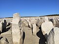
 Partially visible Guadalperal dolmen during summer 2012
 -
 Front view of sculpted menhir
 -
 Sculpted menhir believed to represent the line of the River Tagus


References
- ^ "El Stonehenge español sale a flote: tiene 4.000 años y Franco lo sumergió en un embalse". El Español. August 22, 2019.
- ^ "El Dolmen de Guadalperal". November 5, 2014.Archived 2018-12-07 at the Wayback Machine
- ^ Ciaccia, Chris (2019-09-23). "'Spanish Stonehenge' revealed after spending decades under water". Fox News. Retrieved 2019-09-25.
- ^ Observatory, NASA Earth (2019-09-24). "Dolmen of Guadalperal". ABC News. Retrieved 2019-09-25.
- ^ "'Spanish Stonehenge' revealed after spending decades underwater". www.msn.com. Retrieved 2019-09-25.
- ^ Martinez, Marta Rodriguez (2019-08-28). "Exceptional drought uncovers 5,000-year-old 'Spanish Stonehenge'". euronews. Retrieved 2019-09-25.
- ^ EDT, Aristos Georgiou On 9/19/19 at 12:41 PM (2019-09-19). "NASA spots "Spanish Stonehenge" from space after drought reveals lost megalith monument after 50 years underwater". Newsweek. Retrieved 2019-09-25.
{{cite web}}: CS1 maint: numeric names: authors list (link) - doi:10.11141/ia.60.4.