
Downtown Memphis, Tennessee

Downtown
It is home to the Memphis Redbirds, the AAA affiliate of the St. Louis Cardinals, and the Memphis Grizzlies NBA team.
History

Downtown is the oldest part of the city and includes the riverfront and the bluffs overlooking the Mississippi River. The founders of Memphis dedicated the riverfront to the public "now and forever" as long as the public use continued. The land overlooking the riverfront was originally planned to become a "public promenade" to be called Mississippi Row. The upper riverfront became the site of the river landing where steamboats were loaded with cotton and other goods in the 19th and early 20th centuries. Between 1844 and 1886 the river landing was paved with limestone and granite cobblestones brought in from the upper Midwest. This created what is today the largest intact Mississippi River landing still in existence, and is listed on the National Register of Historic Places.[1] The explosion of the steamboat Sultana in 1865 near Memphis was one of the worst marine disasters in history.
There are several historic residences downtown, particularly in the Victorian Village neighborhood. Other historic homes include the Hunt-Phelan House (1830), the Magevney House (ca. 1835) and the Burkle Estate (1849). The Burkle home and the Hunt Phelan House (533 Beale Street) were reputed to have been part of the underground railroad by which escaped slaves made their way to freedom prior to the Civil War.[2]
Downtown Airport
In 1959, the Memphis Downtown Airport was opened on
Overview
Buildings
The Downtown Memphis skyline contains the tallest buildings in the city. The tallest building in Memphis, 100 North Main, is located at the heart of downtown along Main Street at Adams Ave and rises to 430 ft (131m). Some notable and/or historic downtown buildings are:
- 100 North Main
- One Commerce Square
- Sterick Building
- Exchange Building, Memphis
- Morgan Keegan Tower
- First Horizon Bank Tower
- Memphis Pyramid
- Peabody Hotel
- Madison Hotel
- Scimitar Building
- FedExForum
- Central Station
- 201 Poplar
Downtown Memphis consists of 4.5 million square feet (418,000 square meters) of office space,[4] around 1 million square feet (93,000 square meters) of retail space, 3,456 hotel rooms, and 13,400 housing units.[5]
The administrative core of Memphis and Shelby County is also located in Downtown Memphis. These include the
Districts and neighborhoods
Downtown Core
Downtown Core is the heart of the central business district and includes the majority of office space, retail, entertainment and dining spaces.[5] It is a popular regional destination for entertainment, dining, and tourism and includes attractions such as Beale Street, FedExForum, AutoZone Park, and the Peabody Hotel.
Districts & neighborhoods
- South Main Arts District
- Medical District
- Pinch District
- Peabody Place
- Beale Street
- South Forum (SoFo)
- Uptown
- Greenlaw
- Harbor Town
- The Edge
- Victorian Village
- South Bluffs
- Fort Pickering
Memphis Riverfront

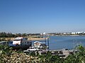
Downtown Memphis is located on the banks of the Mississippi River. The Memphis Riverfront stretches from the Meeman-Shelby Forest State Park in the north, to T. O. Fuller State Park in the south.
The River Walk is a park system along the Mississippi River that connects the Mississippi River Greenbelt Park in the north, to Tom Lee Park in the south.
Points of interest along the riverfront
- Chickasaw Bluff at Beale Street Landing
- Riverfront Trolley
- Mud Island
- Harbor Town
- Pinch District
- Steamboats
- Ashburn-Coppock Park
- President's Island
-
 Memphis River Walk
 -
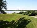 4th Bluff Mounds at Chickasaw Heritage Park
 -
 Harahan Bridge from Martyrs Park
 -
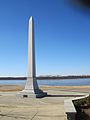
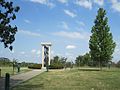 Yellow Fever Memorial in Martyrs Park
 -
 Memphis Park
 -
![Mississippi River Park[7]](//upload.wikimedia.org/wikipedia/commons/thumb/f/f5/Jefferson_Davis_Park_Riverside_Dr_Memphis_TN_03.jpg/120px-Jefferson_Davis_Park_Riverside_Dr_Memphis_TN_03.jpg) Mississippi River Park[7]
Mississippi River Park[7] -
-
 Vance Park
 -
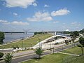 Beale Street Landing
 -
 Memphis Queen
 -
 Mississippi River Greenbelt Park
 -
 Wolf River Harbor
 -

-
 McKellar Lake
 -
 Martin Luther King Jr Park
 -

-
 President's Island


![Mississippi River Park[7]](/File:Jefferson_Davis_Park_Riverside_Dr_Memphis_TN_03.jpg)


Economy
Companies headquartered in Downtown include:
- AutoZone[8]
- First Horizon
- Southern Airways Express (One Commerce Square)[9]
- ServiceMaster (Peabody Place)
Former headquarters:
- Pinnacle Airlines Corp. (One Commerce Square)[10]
Schools
Downtown Memphis is zoned to the following
Transportation
Downtown is served by major highways and interstates, public bus and trolley service by MATA, commercial bus service by Greyhound, and passenger train service by Amtrak.
Interstates
MATA operates the North End Terminal, its primary hub for Memphis public bus service, at the corner of Main Street and A.W. Willis Avenue.[11] The majority of fixed bus routes operates by MATA terminate at the North End Terminal, therefore bus accessibility in the area is very high.[12]
The MATA Trolley is a heritage streetcar system that operates three lines in downtown along Main Street, Riverside Drive, and Madison Avenue. It consists of twenty four stations and, in 2021, had a daily ridership of approximately 650.[13] Connections between MATA public bus and Main Street trolley line can be made at the North End Terminal.
Gallery
-

-
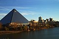 Pyramid Arena
 -

-
 Court Square
 -
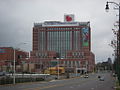 Le Bonheur Children's Medical Center
 -

-

-
 St. Mary's Episcopal Cathedral in Memphis
 -

-
 Civic Center Plaza
 -
 MATA Trolley on Main Street.
 -
 James Lee House (1869), one of the last houses in Downtown.


Historic views
-
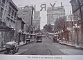
 Beale Street in 1974
 -
 View ofdowntown Memphis, looking west on Madison Ave.
 -
 Downtown Memphisin 1909, overlooking Court Square.
 -
 View ofdowntown Memphis in 1907 from the Mississippi River.
 -
 View of Madison Avenue, and Customs House and Post Office in 1907.
 -
 The Tennessee Club on Court Square, 1906.
 -
 The former Napoleon Hill mansion in Memphis, Tennessee, constructed in 1881 at the corner of 3rd and Madison. The mansion was torn down by 1930 to build the Sterick Building.
 -
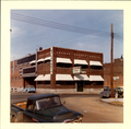 Nylon Net Building circa 1960


References
- ^ http://river.freshbits.com/library/2000/05/on-memphis-waterfront-master-plan-must.html Clubb, Deborah M. On the Memphis Waterfront: Master Plan Must Account for What the Founders Wanted: A Public Promenade Commercial Appeal, Sunday, May 21, 2000.
- ^ Hunt-Phelann House. Archived March 13, 2010, at the Wayback Machine
- ISBN 0-7385-2441-7.
- ^ "Memphis MarketBeats | United States". Cushman & Wakefield. Retrieved 2021-03-15.
- ^ a b "Downtown Memphis: Demographics". Archived from the original on 2010-12-21. Retrieved 2011-02-14.
- ^ "Federal Reserve Bank of St. Louis | Memphis Branch". Retrieved Oct. 17, 2013
- ^ Memphis' Confederate Parks Renamed: City Drops 3 Names That Honor Racist Past Reuters
- ^ "Store Support Center." AutoZone. Retrieved on June 4, 2013.
- ^ "Contact Us Archived 2014-10-04 at the Wayback Machine." Southern Airways Express. Retrieved on November 21, 2014. "Southern Airways Express One Commerce Square, 21st Floor P.O. Box 3088 Memphis, TN 38173"
- ^ Risher, Wayne. "Pinnacle's decision to move Downtown lifts hopes for other development." The Commercial Appeal. October 8, 2010. Retrieved on October 8, 2010.
- ^ "MataTransit | Memphis, TN". www.matatransit.com. Archived from the original on 5 December 2008. Retrieved 22 May 2022.
- ^ "MATA-System_Map_Nov20.pdf" (PDF). MATA Memphis Area Transit Authority. Archived (PDF) from the original on 2021-01-17. Retrieved February 4, 2021.
- ^ "Monthly Module Raw Data Release". www.transit.dot.gov. Retrieved 2022-04-05.
- ^ "City of New Orleans Train Chicago, Memphis, New Orleans | Amtrak". www.amtrak.com. Retrieved 2021-02-04.
External links
35°08′20″N 90°03′27″W / 35.1389°N 90.0575°W
Nearby Neighborhoods in Memphis, Tennessee | ||||||||||||||||
|---|---|---|---|---|---|---|---|---|---|---|---|---|---|---|---|---|
| ||||||||||||||||


