
Dry lake
A dry lake bed, also known as a playa, is a basin or depression that formerly contained a standing surface water body, which disappears when evaporation processes exceed recharge. If the floor of a dry lake is covered by deposits of alkaline compounds, it is known as an alkali flat. If covered with salt, it is known as a salt flat.
Terminology
If its basin is primarily salt, then a dry lake bed is called a salt pan, pan, or salt flat (the latter being a remnant of a salt lake). Hardpan is the dry terminus of an internally drained basin in a dry climate, a designation typically used in the Great Basin of the western United States.[citation needed]
.jpg)
Another term for dry lake bed is playa. The Spanish word playa (pronounced
In South America, the usual term for a dry lake bed is salar or salina, Spanish for salt pan.
Pan is the term used in most of South Africa. These may include the small round highveld pans, typical of the Chrissiesmeer area, to the extensive pans of the Northern Cape province.
Terms used in Australia include salt pans (where evaporite minerals are present) and clay pans.[1]
In Arabic, a salt flat is called a sabkha (also spelled sabkhah, subkha or sebkha) or shott (chott). In Central Asia, a similar "cracked mud" salt flat is known as a takyr. In Iran salt flats are called kavir.
Formation

A dry lake is formed when water from rain or other sources, like intersection with a water table, flows into a dry depression in the landscape, creating a pond or lake. If the total annual evaporation rate exceeds the total annual inflow, the depression will eventually become dry again, forming a dry lake. Salts originally dissolved in the water precipitate out and are left behind, gradually building up over time. A dry lake appears as a flat bed of clay, generally encrusted with precipitated salts. These evaporite minerals are a concentration of weathering products such as sodium carbonate, borax, and other salts. In deserts, a dry lake may be found in an area ringed by bajadas.
Dry lakes are typically formed in semi-
Many dry lakes contain shallow water during the rainy season, especially during wet years. If the layer of water is thin and is moved around the dry lake bed by wind, an exceedingly hard and smooth surface may develop. Thicker layers of water may result in a "cracked-mud" surface and teepee structure desiccation features. If there is very little water, dunes can form.
The
Ecology
While a dry lake bed is itself typically devoid of vegetation, they are commonly ringed by
In southwest
Lepidium davisii is another rare species, a perennial plant whose habitat is restricted to playas in southern Idaho and northern Nevada.[6]
Far from major rivers or lakes, playas are often the only water available to wildlife in the desert. Antelope and other wildlife gather there after rainstorms to drink.
Threats to dry lakes include pollution from concentrated animal feeding operations such as cattle
Human use
The extremely flat, smooth, and hard surfaces of dry lake beds make them ideal for fast motor vehicles and motorcycles. Large-sized dry lakes are excellent spots for pursuing land speed records, as the smoothness of the surface allows low-clearance vehicles to travel very fast without any risk of disruption by surface irregularities, and the path traveled has no obstacles to avoid. The dry lake beds at Bonneville Salt Flats in Utah and Black Rock Desert in Nevada have both been used for setting land speed records. Lake Eyre and Lake Gairdner in South Australia have also been used for various land speed record attempts. Dry lake beds that very rarely fill with water are sometimes used as locations for air bases, for similar reasons. Examples include Groom Lake at Area 51 in Nevada, and Edwards Air Force Base (originally known as Muroc Dry Lake) in California.
Under United States law, a "playa lake" may be considered isolated
The Burning Man yearly event takes place in a playa in the Black Rock Desert in western Nevada every year.
Fangfang Yao et al (2023),[8] at the University of Virginia reported that more than half of the world's large lakes are drying up. They assessed almost 2,000 large lakes using satellite measurements combined with climate and hydrological models. based on their finding, that unsustainable human use, changes in rainfall and run-off, sedimentation, and rising temperatures have driven lake levels down globally, with 53% of lakes showing a decline from 1992 to 2020.[9]
Gallery
-
 Devil's Golf Course in Death Valley National Park, western United States
 -
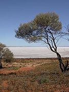 The dry lake and shore ofendorheic desert lake in South Australia.
 -
 A closeup photograph of salt growths on the crust of a dry lake.
 -
 Etosha pan in northern Namibia


See also
- List of drying lakes
- Lake
- Cienega– Wetland system unique to the American Southwest
- Salt storm
- Soil salinity – Salt content in the soil
References
- ISBN 1 877058 32 7
- ^ "Uyuni Salt Flat" Encyclopædia Britannica
- PMID 25162535.
- ^ "Ice rafts not sails: Floating the rocks at Racetrack Playa" (PDF). Barnesos.net. Retrieved 2016-06-24.
- doi:10.1651/C-2509.1. Archived from the original (PDF) on 9 October 2018. Retrieved 2 May 2014.)
{{cite journal}}: CS1 maint: multiple names: authors list (link - ^ a b Hagwood, Sheri. "Sensitive Plants of the JRA" (PDF). Idaho BLM. Archived from the original (PDF) on 3 May 2014. Retrieved 2 May 2014.
- ^ "CRS Report for Congress: Agriculture: A Glossary of Terms, Programs, and Laws, 2005 Edition - Order Code 97-905" (PDF). Archived from the original (PDF) on August 10, 2011. Retrieved November 30, 2009.
A temporary lake created in the lowest elevation of a basin in an arid area that has no surface drain into another water body, such as a perennial stream or river. Lake water is removed either by evaporation into the air or seepage into the ground.
- S2CID 258765167.
- ^ Dickie, Gloria (2023-05-19). "More than half of the world's large lakes are drying up, study finds". Reuters. Retrieved 2023-05-20.
Bibliography
- Briere, Peter R. (May 2002). "Playa, playa lake, sabkha: Proposed definitions for old terms". Journal of Arid Environments. 45 (1). Elsevier: 1–7. .
- John H. Wellington, Southern Africa: a geographical study, Chapter 16 LAKES AND PANS
| Authority control databases: National |
|---|