Duchy of Austria
This article relies largely or entirely on a single source. (January 2023) |
Duchy of Austria Herzogtum Österreich (German) | |||||||||||
|---|---|---|---|---|---|---|---|---|---|---|---|
| 1156–1453 | |||||||||||
Habsburg duke) | |||||||||||
• 1440–1457 | Ladislaus I (last duke, archduke from 1453) | ||||||||||
| Historical era | Middle Ages | ||||||||||
| 17 September 1156 | |||||||||||
| 17 August 1186 | |||||||||||
| 26 August 1278 | |||||||||||
| 1358/59 | |||||||||||
| 25 September 1379 | |||||||||||
• Archduchy recognized | 6 January 1453 | ||||||||||
| ISO 3166 code | AT | ||||||||||
| |||||||||||
The Duchy of Austria (
Geography
Initially, the duchy was comparatively small in area, roughly comprising the modern-day Austrian state of Lower Austria. As a former border march, it was located on the eastern periphery of the Empire, on the northern and southern shores of the Danube River, east of ("below") the Enns tributary.
History
The territory originally inhabited by
About 800, Charlemagne, having won several victories against the Avars, established a frontier
House of Babenberg
Although today closely associated with the
The new Austrian duke took his residence at

In 1191, Duke Leopold V joined the
His son Leopold VI, sole ruler of the Austrian and Styrian lands from 1198, married the Byzantine princess
However, Leopold's son, Duke Frederick II the Warlike, entered into fierce conflicts soon after his accession in 1230, not only with the Austrian nobility, but also with King Wenceslaus I of Bohemia, King Andrew II of Hungary and even with Emperor Frederick II for the alleged entanglement in the rebellion of the duke's brother-in-law Henry of Hohenstaufen. The latter earned him an Imperial ban and an expulsion from Vienna in 1236. Though he could later reconcile with the Emperor, the border conflict with Hungary culminated in several clashes of arms after 1242, after King Béla IV of Hungary marched into Austria to reconquer occupied lands. Duke Frederick was killed at the 1246 Battle of the Leitha River, whereby the Babenberg line became extinct in the male line.
Fortune and fall of King Ottokar
According to feudal law, the immediate heritable fees fell back to the suzerain, the Holy Roman Emperor. However, Emperor Frederick II, in the last years of his rule, was weakened by the struggle against Pope Innocent IV, and was stuck in the Italian Wars between the Guelphs and Ghibellines. His death in 1250 and the death of his only surviving son King Conrad IV four years later ended the line of Hohenstaufen rulers, only eight years after the extinction of the Babenberg dynasty. The extinction led to the Great Interregnum, a period of several decades during which the status of the country's rulers was disputed. While in the following years several candidates were elected King of the Romans, none of them were able to control the Empire.

It was the ambitious Přemyslid ruler
In 1269, Ottokar also effectively controlled the Duchy of Carinthia, with Carniola and the Windic March further in the south. He controlled, in all, a Central European realm stretching from the Polish border in the Sudetes towards the Adriatic coast in the south. When he failed to be elected King of the Romans in 1273, he contested the election of the successful candidate, the Swabian count Rudolf of Habsburg. Nevertheless, Rudolf was able to secure his rule as the first actual German king after the Great Interregnum. By his Imperial authority he seized Ottokar's "alienated" territories and added them to his already extensive homelands in Swabia. King Ottokar was finally defeated and killed by the united Austrian and Hungarian forces in the 1278 Battle on the Marchfeld.
House of Habsburg

Rudolf married his daughter Judith off to Ottokar's son Wenceslaus II, who retained the Bohemian kingdom. Having reached an agreement with the prince-electors, he granted the Austrian domains to his sons Albert and Rudolf II at the 1282 Diet of Augsburg, elevating them to Princes of the Holy Roman Empire. The right of primogeniture was implemented with the Treaty of Rheinfelden one year later. Rudolf's descendants ruled Austria and Styria until 1918.
In the 14th and 15th centuries, the Habsburgs accumulated further provinces in the southeastern part of the Empire: the
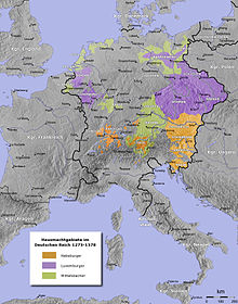
The following two centuries were turbulent for the duchy. Under Habsburg rule, several inquisitorial persecutions against Waldensians were carried out, notably by the cleric Petrus Zwicker in the late 14th century. Following the brief, yet eventful, rule of Duke Rudolf IV, his brothers Albert III and Leopold III divided the Austrian domains between themselves, in accordance with the Treaty of Neuberg, signed in 1379. Albert retained Austria proper, while Leopold took the remaining territories. In 1402, there was another split in the Leopoldian line, when Duke Ernest took Inner Austria (i.e. the duchies of Styria, Carinthia, and Carniola) and Duke Frederick IV became the ruler of Tyrol and Further Austria. The partitions decisively weakened the Habsburg position, in favour of their rivals from the Luxembourg and Wittelsbach dynasties.
The Habsburg Albertinian line was again elevated to the Imperial throne in 1438. Duke Albert V of Austria was chosen King of the Romans as the successor to his House of Luxembourg father-in-law, Emperor Sigismund. Although Albert's reign spanned only one year, he was succeeded by his Leopoldian cousin, Duke Ernest's son, Frederick V, who eventually reunified the Habsburg territories, after the extinctions of the Albertinian line (1457) and the Elder Tyrolean line (1490). Duke Frederick was crowned Holy Roman Emperor (as Frederick III) in 1452; he formally acknowledged the elevation of Austria to an archduchy one year later, whereafter all Habsburg princes bore the archducal title. Only two non-Habsburgs reigned the Empire between 1438 and 1806, when Emperor Francis II resigned.
See also
References
- ^ "Austria – The Holy Roman Empire and the Duchy of Austria". countrystudies.us. Retrieved 2023-02-21.
- ISBN 0-520-04206-9.


