
Ducie Island
British Overseas Territory ) |


Ducie Island (/ˈduːsi/; Pitkern: Ducie Ailen) is an uninhabited atoll in the Pitcairn Islands group, which also includes Pitcairn, Henderson and Oeno islands. Ducie lies east of Pitcairn Island, and east of Henderson Island, and has a total area of 1.5 square miles (3.9 km2), which includes the lagoon. It is 1.5 miles (2.4 km) long, measured northeast to southwest, and about 1 mile (1.6 km) wide.[1] The island is composed of four islets: Acadia, Pandora, Westward and Edwards.
Despite its sparse vegetation, the atoll is known as the breeding ground of a number of bird species. More than 90% of the world population of Murphy's petrel nests on Ducie, while pairs of red-tailed tropicbirds and fairy terns make around 1% of the world population for each species.
Ducie was first discovered in 1606 by
History
The island was discovered by a Spanish expedition led by Portuguese sailor
Ducie Island was the first of eighteen discoveries on the trip. Queirós named the island Luna Puesta (roughly, "moon that has set"). On the same day, he also sighted two more islands, one that he named San Juan Bautista ("St John the Baptist"), and the other La Encarnación ("the Incarnation"). It is unclear which one was Henderson island and which one was Pitcairn.[5] The confusion was later compounded when a chart produced by Admiral José de Espinosa marked Ducie as La Encarnación, rather than as Luna Puesta.[6]
The island was rediscovered and named Ducie Island on 16 March 1791 by Captain Edward Edwards, of HMS Pandora, who had been despatched from Britain in 1790 to arrest the Bounty mutineers.[6] Edwards named it in honour of Francis Reynolds-Moreton, 3rd Baron Ducie, under whom he had served earlier in his career.[7] HMS Pandora turned northwards from Ducie and, because of this change of course, Edwards did not sight the other islands of the group. If HMS Pandora had maintained its course, it would eventually have reached Pitcairn Island and found the Bounty mutineers.[8]
The crew of the
In March 1867, John Daggett filed a claim on Ducie Island (referring to it as 'Ducer Island') with the U.S. State Department under the Guano Islands Act. Daggett was instructed to provide further information, including to affidavits of the quality and quantity of guano present on the island; however, according to a 1933 State Department report, Daggett never provided the additional information and the claim was never accepted by the United States.[12]

On 5 June 1881, the mail ship Acadia ran aground on the island while returning from San Francisco, Peru after unloading its cargo. On the way to Queenstown or Falmouth for new orders, Master Stephen George calculated a route passing 15 to 20 miles (24 to 32 km) to the east of Ducie. George left the first mate in command at 6 am. Half an hour later, the first mate saw a white line, which he disregarded on the assumption that it was phosphorescence in the water. Later, realising that it was land, he manoeuvred to avoid running aground, but failed. The look-out excused himself by saying that he thought that the white land was a cloud. The crew made several unsuccessful attempts to re-float the ship, after which the master sailed one of the ship's boats to Pitcairn Island. He was assisted there by the local inhabitants and returned aboard the Edward O'Brien, an American boat, to rescue the rest of the crew. The incident was later investigated in a court in Liverpool, where the ultimate cause of the wreck was left undetermined, though possible causes included a calculation error by the master or an unknown current that carried the ship to the island. The court declared the master not guilty of any wrongdoing.[13] A stone marker with a memorial inscription is located at the landing point on Acadia Islet. It was unveiled to commemorate the recovery of the anchor in 1990. The wreck lies offshore from the memorial stone in about 10 metres of water.[14]
In 1969, the atoll was proposed as an "Island for Science",
Sovereignty
Although Captain Edward Edwards discovered the atoll in 1791, Ducie was not considered a British possession.[23] In 1867 Ducie was claimed by the United States under the Guano Islands Act, which established that an uninhabited territory with guano deposits could be claimed as a US possession, so long as it was unclaimed by any other country.[24] Despite claims on several other territories, based on various documents such as the Guano Islands Act, neither the United States nor the United Kingdom recognised the sovereignty claimed by each other. Neither of the two considered that the mere discovery of an island was sufficient to claim sovereignty over it,[25] and often a formal act of possession was considered the proper procedure to claim rights over a territory.[23] Ultimately, the United States did not assert its sovereignty over most of its claimed territories.[25]
Under the 1893 Pacific
On 4 August 1937, Captain J. W. Rivers-Carnac, commander of
Geography


Ducie lies 290 miles (470 km) east of Pitcairn Island and is claimed by some to be the southernmost atoll in the world at 24°41' S latitude.[32] However, Elizabeth Reef in the Tasman Sea is at 29°57 S latitude, so the assertion on behalf of Ducie Island is doubtful. Ducie Island's land area is 170 acres (69 ha) and its maximum elevation, occurring on the Westward islet, is 15 feet (4.6 m).[33]
Ducie is located 620 miles (1,000 km) west of the edge of the
The atoll consists of four islets: Acadia—which is by far the largest—Pandora, Westward and Edwards.[36] All three of the smaller islets can be accessed on foot from Acadia at low tide.[32] The islets were named by Harald Rehder and John Randall, who visited the atoll during an expedition by the Smithsonian Institution in 1975.[37]
- Acadia Islet, along the atoll's north and east rim, is several times larger than the other three islets combined, measuring 140 acres (57 ha).[32] Very long and thin, the islet is largely forested and is composed of ridges of coral rubble. It is named after the Acadia, a ship that was wrecked on Ducie in 1881.[38]
- Pandora Islet, in the south, is the second largest. It is composed of sand and coral rubble that borders the lagoon. It is named after HMS Pandora.[39]
- Edwards Islet lies immediately to the east of Pandora Islet and has the same characteristics. It is named after Edward Edwards, captain of HMS Pandora.[39]
- Westward Islet, west of Pandora Islet, is the smallest. It appears sandy from a distance, but the soil is composed of coral rubble and dead shells. Its highest point rises 15 feet (4.6 m) above average sea level. It is named after the Westward, the ship that carried the members of the National Geographic Society and the Oceanic Institute during their 1970–71 expedition.[33]
The atoll has a central lagoon, accessible by boat only by way of a channel 100 yards (91 m) wide located in the southwest, between Pandora and Westward Islets.[40] It has a maximum depth of 52 feet (16 m) and its bottom consists of sand and coral.[41] Whirlpools in the lagoon are common, caused by caves that drain the water from the lagoon into the ocean.[21]
Pandora is known as being one of the three coastline vertices for
Flora
The vegetation in the atoll is sparse, because of the lack of fresh water.
During the expedition of Hugh Cuming in 1827 and the 1922 Whitney South Sea Expedition, Lepturus grass was found on Acadia Islet.[46] However, it disappeared when storm waves deforested the island some time before the Smithsonian expedition of 1975.[47] Thus H. foertherianum now dominates the vegetation of the islets.[48] Additionally, there are a number of species of coralline algae, including Porolithon onkodes, Porolithon gardineri, and Caulerpa racemosa.[41]
Fauna
The atoll is populated by several species of birds, fish, and reptiles. In the lagoon, sparse, living coral can be found;[32] the dominant species is Montipora bilaminata (family Acroporidae).[41] Most of the coral in the lagoon is dead, presumed to have been killed by influxes of cold water.
Birds
Though no terrestrial birds are found on the atoll,[22] Ducie Island is known for the seabirds that breed there.[14] Birds that have been recorded nesting on the atoll include the red-billed tropicbird, red-tailed tropicbird, white tern, great frigatebird, masked booby, and red-footed booby. Wintering bristle-thighed curlews have been recorded as well. A number of tern species, including the sooty tern, blue noddy, brown noddy, lesser noddy, and white tern have been recorded, as have several members of the family Procellariidae: Kermadec petrel, Trindade petrel, Murphy's petrel, and Christmas shearwater.[49]
The island is particularly important for Murphy's petrel, as more than 90% of its world population breeds on Ducie.[50] Around 3,000 pairs of Christmas shearwaters, about 5% of the world's total population, can be found on the island too. Meanwhile, the red-tailed tropicbirds and white terns that breed on Ducie are around 1% of the world population of each species.[32] Phoenix petrels, which previously inhabited the atoll, apparently disappeared between the Whitney expedition in 1922 and the 1991–92 Pitcairn Scientific Expedition.[22] The island has been identified by BirdLife International as an Important Bird Area (IBA), principally for its colonies of Murphy's, herald, and Kermadec petrels, and Christmas shearwaters.[51]
-
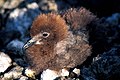 Murphy's petrel chick
 -
 Fairy tern
 -
 Red-tailed tropicbird
 -
 White tern chick


Fish
In the lagoon there are around 138 fish species, which also inhabit southeastern Oceania, the Western Pacific, and the Indian Ocean.
Terrestrial vertebrates
Lizards that inhabit the island include the
See also
- List of Guano Island claims
- List of islands
- Desert island
References
- ^ Wahlroos, Sven (1989). Mutiny and Romance in the South Seas: a Companion to the Bounty Adventure. Topsfield, Massachusetts: Salem House. p. 280.
- ^ Brooke, M. de L. "Pitcairn Islands" (PDF). Birdlife International. p. 193. Retrieved 24 January 2022.
Ducie receives visits once or twice a year from cruise ships, which land their passengers on the north shore of Acadia. It is quite possible that there are other visits that are unrecorded, but probably infrequent.
- ^ Brand, Donald D. The Pacific Basin: A History of its Geographical Explorations The American Geographical Society (New York, 1967) p.136.
- ^ Paine, Lincoln; p.122
- ^ a b c d "History of Government and Laws, Part 15". Pitcairn Islands Study Center. Pacific Union College. Archived from the original on 11 December 2014. Retrieved 10 July 2011.
- ^ a b Edwards, Edward; p.60
- ^ Heffernan, Thomas; p.80
- ^ Edwards, Edward; p.5
- ^ Whipple, A.B.C p. 150
- ^ Beechey; p.60
- ^ Rehder, Harald A.; Randall, John E.; p.6
- ^ Rogers, E.S. (9 January 1933). The Sovereignty of Guano Islands in the Pacific Ocean (Report). Washington, D.C.: Department of State, Office of the Legal Advisor. pp. 234–235.
- ^ Board of Trade p.1
- ^ a b McKinnon, Rowan; p.249
- ^ a b c "The Wetlands: Ducie Atoll". Wetlands International. Pacific Union College. Retrieved 17 July 2011.
- ^ Ramsar; p. 3
- ^ The Royal Society of New Zealand, p.161
- ^ Paulay, G (1989) Atoll Research Bulletin NO. 326
- ^ Benton T. G. and Spencer T., eds. (1995). The Pitcairn Islands: Biogeography, Ecology and Prehistory. 422 + xxxi pp. London: Academic Press
- ^ "Sharks of Lost Island". National Geographic. Archived from the original on 18 June 2013.
- ^ a b c d Stanley, David (7th edition); p.286
- ^ a b c Ramsar Information Sheet: UK62001; p.4
- ^ a b Orent, Beatrice; Reinsch, Pauline; p.444
- ^ United States Department of Justice; p.555
- ^ a b Orent, Beatrice; Reinsch, Pauline; p.443
- ^ a b Ntumy, Michael A.; p.253
- ^ Rehder, Harald A.; Randall, John E.; p.7
- ^ Orent, Beatrice; Reinsch, Pauline; p.445
- ^ Orent, Beatrice; Reinsch, Pauline; p.447
- ^ Ntumy, Michael A.; p.254
- ^ The Pitcairn Constitution Order 2010; p.28
- ^ a b c d e f g Ramsar Information Sheet: UK62001; p.2
- ^ a b Rehder, Harald A.; Randall, John E.; p.11
- ^ Spencer; p.5
- ^ Spencer; p.1
- ^ a b Vacher; Quinn p.410
- ^ Rehder, Harald A.; Randall, John E.; p.9
- ^ Rehder, Harald A.; Randall, John E.; p.12
- ^ a b Rehder, Harald A.; Randall, John E.; p.13
- ^ Rehder, Harald A.; Randall, John E.; p.15
- ^ a b c Rehder, Harald A.; Randall, John E.; p.14
- ^ "Point Nemo, revisited".
- ^ Procter, D.; Fleming, L.V.; p. 90
- ^ Frodin, D. G. (2001) Guide to standard floras of the world: an annotated, geographically arranged systematic bibliography of the principal floras, enumerations, checklists, and chorological atlases of different areas, Cambridge University Press, 2nd ed.
- ^ Quayle, Ernest H.; p.392
- ^ a b Rehder, Harald A.; Randall, John E.; p.18
- ^ Rehder, Harald A.; Randall, John E.; p.8
- ^ Fosberg et al. p.18
- ^ Rehder, Harald A.; Randall, John E.; pp.18 20
- ^ IUCN (2010); "Pterodroma ultima".
- ^ BirdLife International. (2012). Important Bird Areas factsheet: Ducie Island. Downloaded from "BirdLife International - conserving the world's birds". Archived from the original on 30 June 2007. Retrieved 20 March 2013. on 2012-01-21.
- ^ a b Rehder, Harald A.; Randall, John E.; p.26
- ^ "Ducie Island". Pitcairn Islands Study Center. Pacific Union College. Retrieved 3 July 2011.
- ^ Rehder, Harald A.; Randall, John E.; p.17
- JSTOR 1444304.
- ISBN 92-5-101384-5.
- ^ UK62001; p.3
- ^ Rehder, Harald A.; Randall, John E.; p.20
- ^ The Royal Society of New Zealand p.162
- ^ Ford, H. (2012) Pitcairn Island as a Port of Call: A Record, 1790-2010, 2d ed.
- ^ MacLean; p.198
Bibliography of sources
- Beechey, Frederick William (1831). Narrative of a Voyage to the Pacific and Beering's Strait: to co-operate with the Polar Expeditions: Performed in His Majesty's Ship Blossom, Under the Command of Captain F.W. Beechey ...in the Years 1825, 26, 27, 28. H. Colburn and R. Bentley.
- Besant, Walter (2007). The Mutineer: A Romance of Pitcairn Island. Echo Library. ISBN 978-1-4068-2375-2.
- Edwards, Edward (2009). Voyage of HMS Pandora: Despatched to Arrest the Mutineers of the "Bounty". Books on Demand. ISBN 978-3-86195-087-5.
- Fosberg, F. Raymond; Paulay, Gustav; Spencer, T; Oliver, Royce (1989). "New Collections and Notes on the Plants of Henderson, Pitcairn, Oeno, and Ducie Islands" (PDF). Smithsonian Institution Press.
- Frodin, D.G (2001). Guide to Standard Floras of the World: an Annotated, Geographically Arranged Systematic Bibliography of the Principal Floras, Enumerations, Checklists, and Chronological Atlases of Different Areas. Cambridge University Press. ISBN 978-0-521-79077-2.
- Gill, B.J (22 July 1993). "The Lizards of the Pitcairn Island Group, South Pacific". New Zealand Journal of Zoology. 20 (3). The Royal Society of New Zealand: 161–164. .
- Heather, Barrie; Robertson, Hugh (2000). The Field Guide to the Birds of New Zealand. Viking. ISBN 978-0-670-89370-6.
- Heffernan, Thomas Farel (1990). Stove by a Whale: Owen Chase and the Essex. Wesleyan University Press. ISBN 0-8195-6244-0.
- Hight, Edward; Ward, C.W (1881). "Board of Trade Wreck Report for 'Acadia', 1881" (PDF). Board of Trade. Archived from the original on 25 November 2011.
{{cite web}}: CS1 maint: unfit URL (link) - BirdLife International (2019). "Pterodroma ultima". . Retrieved 12 November 2021.
- Maclean, Norman (2010). Silent Summer: The State of Wildlife in Britain and Ireland. Cambridge University Press. ISBN 978-0-521-51966-3.
- McKinnon, Rowan (2009). South Pacific. Lonely Planet. ISBN 978-1-74104-786-8.
- Moore, John Basset (1906). A Digest of International Law: As Embodied in Diplomatic Discussions, Treaties and Other International Agreements, International Awards, the Decisions of Municipal Courts, and the Writings of Jurists. United States Department of Justice.[clarification needed]
- Ntumy, Michael A. (1993). South Pacific Islands Legal Systems. University of Hawaii Press. ISBN 978-0-8248-1438-0.
- Orent, Beatrice; Reinsch, Pauline (1941). "Sovereignty Over Islands in the Pacific". The American Journal of International Law. 35 (13). American Society of International LawStable: 443–461. S2CID 147357598.
- Paine, Lincoln (2000). Ships of discovery and exploration. Houghton Mifflin Harcourt. ISBN 978-0-395-98415-4.
- Procter, D.; Fleming, L.V. (1999). Biodiversity: The UK Overseas Territories (PDF). Joint Nature Conservation Committee. ISBN 1-86107-502-2.
- Quayle, Ernest H. (September 1921 – March 1922). "Journal of Whitney South Sea Expedition of the American Museum of Natural History". American Museum of Natural History. 3.
- Rehder, Harald A.; Randall, John E. (15 January 1975). "Ducie Atoll: Its Story, Phisiography and Biota" (PDF). Smithsonian Institution Press.
- Spencer, T (October 1989). "Tectonic and Environmental Histories in the Pitcairn Group, Palaeogene to Present: Reconstructions and Speculations" (PDF). Smithsonian Institution Press.
- Stanley, David (2000). South Pacific Handbook (7 ed.). Avalon Travel. ISBN 978-1-56691-172-6.
- Vacher, Leonard; Quinn, Terrence (1997). Geology and Hydrogeology of Carbonate Islands. Elsevier. ISBN 978-0-444-81520-0.
- Whipple, A.B.C (10 November 1952). "Three-Month Ordeal in Open Boats". Life Magazine. Time Warner Inc. ISSN 0024-3019.
- "Pitcairn Islands: Introduction" (PDF). Ramsar. Wetlands International. Archived from the original (PDF) on 28 July 2011. Retrieved 3 July 2011.
- "Ramsar Information Sheet: UK62001" (PDF). Joint Nature Conservation Committee, Wetlands International. 13 November 2004.
- The Pitcairn Constitution Order (PDF). Her Majesty's Stationery Office Limited, Queen's printer of Acts of Parliament. 2010. Archived from the original (PDF) on 1 February 2020. Retrieved 10 July 2011.
External links
Pitcairn Islands articles | |||
|---|---|---|---|
| Islands |  | ||
| Settlement | |||
| Politics | |||
| Culture |
| ||
| Other topics |
| ||
| Authority control databases: National |
|---|
24°41′S 124°47′W / 24.683°S 124.783°W