
Dunajec
| Dunajec | |
|---|---|
 Dunajec viewed from Trzy Korony | |
| Location | |
| Country | Poland, Slovakia |
| Physical characteristics | |
| Mouth | |
• location | Vistula |
• coordinates | 50°14′35″N 20°43′42″E / 50.2431°N 20.7283°E |
| Length | 249 km (155 mi) |
| Basin size | 6,796 km2 (2,624 sq mi) |
| Discharge | |
| • average | 85.5 m3/s (3,020 cu ft/s) |
| Basin features | |
| Progression | Vistula→ Baltic Sea |
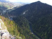
The Dunajec (Polish pronunciation: [duˈnajɛt͡s]; Goral dialects: Dónajec; Slovak pronunciation: [ˈdunajet͡s]) is a river running through northeastern Slovakia and southern Poland. It is also regarded as the main river of the Goral Lands. It is a right tributary of the Vistula River. It begins in Nowy Targ at the junction of two short mountain rivers, Czarny Dunajec and Biały Dunajec (Black and White Dunajec). Dunajec forms the border between Poland and Slovakia for 17 kilometres (11 mi)[1] in the Pieniny Środkowe (Slovak: Centrálne Pieniny) range, east of the Czorsztyn reservoir.
Geography
The Dunajec is 249 kilometres (155 mi) long, including its source river
.Below the two source streams, the Dunajec flows through a broad valley called Nowotarska Basin. It then supplies the waters of the dam in
Towns and townships

The Dunajec flows through or near these locations in Poland and north Slovakia:
|
|
Gallery
-
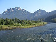 Dunajec and the Trzy Korony Mountain
 -
 Dunajec in autumn
 -
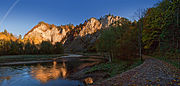
 Dunajec Gorge in the Pieninymountains
 -
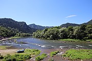
 Dunajec in Sromowce Niżne
 -
 Dunajec in Szczawnica


See also
- Dunajec River Gorge
- Rivers of Poland
- Rivers of Slovakia
- 1934 flood in Poland
- Dunajec river castles
References
- ^ Statistics Poland, p. 85-86
Tributaries of the Vistula River | ||
|---|---|---|
| Forming rivers |
|  |
| Main tributaries of the left bank | ||
| Main tributaries of the right bank |
| |
| Distributary |
| |
| International | |
|---|---|
| National | |