
Eşen River
| Eşen Seki Çayı | |
|---|---|
 Eşen River | |
| Native name | Xanthos (Lycian) |
| Location | |
| Country | Turkey |
| Provinces | Antalya, Burdur, Muğla |
| Districts (ilçe) | Korkuteli, Seydikemer, Altınyayla, Fethiye, Kaş |
| Physical characteristics | |
| Source | At the west side of Kızılca Dağ, Taurus Mountains |
| • elevation | 2000 m |
| Mouth | Mediterranean Sea |
• location | Border between Muğla Province and Antalya Province |
• coordinates | 36°17′37″N 29°15′45″E / 36.2935°N 29.2625°E |
• elevation | 0 m |
| Length | 120 km (75 mi) |
| Basin features | |
| Tributaries | |
| • left | Karaçay |
| • right | Akçay |
Eşen River (
ilçe (district) of Muğla Province.[1]
The river although quite short is known for its touristic importance.
In the antiquity the river as well as the ancient city by the river was known as Xanthos. Both Patara and Letoon are nearby. Currently visitors enjoy rafting in the lower course of the river which draws the border line between Muğla and Antalya Provinces.[2]
Gallery
-
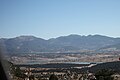 View to the north of the Eşen Dam near Yaylapatlangıç; Seydikemer District, Muğla Province, Turkey.
 -
 Ören Canyon near Ören, Seydikemer County, Muğla Province; looking north.
 -
 View of the Eşen Çayı (Xanthos) in the Ören Canyon; Seydikemer County, Muğla Province; towards the northeast.


References
| Black Sea |
|
|---|---|
| Marmara | |
| Aegean | |
| Mediterranean Sea | |
| Persian Gulf | |
| Caspian |
|
| Authority control databases: Geographic |
|---|