
East Kalimantan
East Kalimantan
Kalimantan Timur | |
|---|---|
| Province of East Kalimantan | |
|
Int$ 50,162 (PPP) | |
| - Growth | |
| HDI | |
| Website | kaltimprov.go.id |
East Kalimantan (Indonesian: ⓘ) is a province of Indonesia. Its territory comprises the eastern portion of Borneo. It had a population of about 3.03 million at the 2010 census (within the current boundary),[4] 3.42 million at the 2015 census, and 3.766 million at the 2020 census;[5] the official estimate as at mid 2022 was 3,859,783.[1] (but see Note (b) below table under "Administrative divisions") Its capital is the city of Samarinda.
East Kalimantan has a total area of 127,346.92 square kilometres (49,168.92 sq mi)[6] and is the second least densely populated province in Kalimantan.[7] The majority of the region shares a maritime border to the east with West Sulawesi and Central Sulawesi; its Cape Mangkalihat separates the Makassar Strait from the Celebes Sea. Its former northernmost region was split off in October 2012 and is now North Kalimantan; meanwhile it still shares land border to the west with West Kalimantan and Central Kalimantan; to its south, East Kalimantan borders South Kalimantan. The province bordered Sabah before the split, but still borders Sarawak.
In December 2012, the existing West Kutai Regency was split in two, with the northwesternmost five districts forming a new
New national capital
The province will host the future
History
Prehistory

East Kalimantan was once mostly covered by tropical rainforest. In prehistoric times, there was limestone cave called Lubang Jeriji Saléh located in the Sangkulirang-Mangkalihat Karst in the district of Bengalon, East Kutai, believed to contain one of the oldest figurative art in the world.[11] The cave paintings were first spotted in 1994 by the French explorer Luc-Henri Fage and the French archaeologist Jean-Michel Chazine, from Kalimanthrope.[12] In 2018, a team of scientists investigating the cave, led by Maxime Aubert from Griffith University and Pindi Setiawan from the Bandung Institute of Technology, published a report in the journal Nature identifying the paintings as the world's oldest known figurative art.[13][14] The team had previously investigated cave paintings in the neighbouring island of Sulawesi.[15] In order to date the paintings, the team used dating techniques on the calcium carbonate (limestone) deposits close to them.[10][16]
4th century to 17th century

East Kalimantan is home to several kingdoms, such as the first and oldest Hindu kingdom of Indonesia, the
18th century to 20th century
In accordance with treaties, on January 1, 1817, Sultan Sulaiman of Banjar handed East Kalimantan, Central Kalimantan, part of West and South Kalimantan (including Banjarmasin) over to the Dutch East Indies. On May 4, 1826, Sultan Adam al-wathiq Billah of Banjar reaffirmed the handover of these territories to the Dutch East Indies colonial administration. In 1846, the Dutch began to put a Resident Assistant in East Borneo at Samarinda (now the province of East Kalimantan and the eastern part of South Kalimantan) named H. Von Dewall. East Kalimantan was then part of the Dutch East Indies. East Kalimantan with its then administrative area was established based on the Law No. 25 of 1956 with the first governor being APT Pranoto.
Split of North Kalimantan province
North Kalimantan was formally inaugurated as the 34th province of Indonesia on April 15, 2013. The new province was previously part of East Kalimantan Province.[18]
Geography
East Kalimantan Province comprises a land area of 125,336.81 square kilometers and a comprehensive ocean management area of 25,656 km2, located between 113°44'E and 119°00'E, and between 2°33'N and 2°25'S. The province is divided into seven regencies (kabupaten) and three cities (kota), together subdivided into 103 districts (kecamatan) and then into 1,026 villages (rural desa and urban kelurahan). The regencies (with their administrative capitals) and cities are enumerated below. East Kalimantan is one of the main gates to the eastern part of Indonesia. The area is also known as a storehouse of timber and mining, has hundreds of rivers (scattered across almost all regencies and cities) which area the main means of transportation in addition to land transport, with the longest river being the Mahakam.
East Kalimantan borders
Climate
Such as the climate of Indonesia in general, East Kalimantan tropical climate and has two seasons, dry and rainy seasons. The dry season usually occurs in May to October, while the rainy season in November to April. This situation continued every year interspersed with transitional season in certain months. Moreover, because of its location on the equator, the climate in East Kalimantan are also affected by wind monsoon, monsoon wind is November–April west and east monsoon winds from May to October. In recent years, the situation in East Kalimantan season is sometimes erratic. In the months that it is supposed to rain, there is no rain at all, or vice versa in the months that should be dry it rains for a much longer time.
Temperature and humidity
Temperatures somewhere high and low are determined by the area of the ocean surface and the distance from the beach. In general, East Kalimantan hot climates with temperatures in 2013 ranged from 21.6 °C in Berau October to 35.6 °C in Berau in September. Aside from being a tropical area with extensive forests, in 2013 the average humidity between 83 and 87 percent of East Kalimantan. The lowest air humidity observed by the meteorological station Samarinda happens in a few months with 82 percent humidity. While the highest occurred in Berau in February with 91 percent humidity.
Rainfall and wind conditions
Rainfall in East Kalimantan region varies by month and location of monitoring stations. Average highest rainfall recorded at the Meteorological Station Berau amounted to 245.1 mm and the lowest for the year 2013 was recorded at the Meteorological Station Samarinda is 237.8 mm. At some monitoring stations monitor wind conditions in East Kalimantan in 2013. Observations show that wind speeds between 3 and 4 knots. The highest wind speed was 4 knots in Balikpapan and Berau, while the lowest was 3 knots in Samarinda.
Administrative divisions
| Year | Pop. | ±% |
|---|---|---|
| 1971 | 733,797 | — |
| 1980 | 1,218,016 | +66.0% |
| 1990 | 1,876,663 | +54.1% |
| 1995 | 2,314,183 | +23.3% |
| 2000 | 2,451,895 | +6.0% |
| 2010 | 3,028,487 | +23.5% |
| 2015 | 3,422,676 | +13.0% |
| 2020 | 3,766,039 | +10.0% |
| 2022 | 3,859,783 | +2.5% |
| Source: Badan Pusat Statistik 2023 and previous. Province; subsequent figures exclude them.These figures before 2010 include the population of the city and four northerly regencies split off in that year to form the new North Kalimantan | ||

When it was first created, East Kalimantan province was composed of four
On 22 October 2012, the Indonesian House of Representatives agreed to the creation of a new province out of the four most northerly of the Regencies in East Kalimantan, namely
| Kode Wilayah |
Name of City or Regency |
Area in km2 |
Pop'n 2010 census |
Pop'n 2015 census |
Pop'n 2020 census |
Pop'n mid 2022 estimate |
Capital | HDI[19] 2019 |
|---|---|---|---|---|---|---|---|---|
| 64.01 | Paser Regency | 11,096.96 | 230,316 | 261,736 | 275,452 | 280,065 | Tanah Grogot | 0.723 (High) |
| 64.09 | Penajam North Paser Regency (Penajam Paser Utara) |
2,923.73 | 142,922 | 154,020 | 178,681 | 183,043 | Penajam | 0.716 (High) |
| 64.71 | Balikpapan City | 512.25 | 557,579 | 614,663 | 688,318 | 703,611 | Balikpapan | 0.801 (Very High) |
| 64.07 | West Kutai Regency (Kutai Barat) |
13,709.92 | 140,097 | 145,728 | 172,288 | 172,288 | Sendawar | 0.716 (High) |
| 64.11 | Mahakam Ulu Regency (Mahakam Ulu) |
19,449.41 | 24,994 | 25,946 | 32,513 | 33,535 | Ujoh Bilang | 0.676 (Medium) |
| 64.02 | Kutai Kartanegara Regency | 25,988.08 | 626,680 | 716,319 | 729,382 | 738,189 | Tenggarong | 0.738 (High) |
| 64.72 | Samarinda City | 716.53 | 727,500 | 811,314 | 827,994 | 834,824 | Samarinda | 0.802 (Very High) |
| 64.73 | Bontang City | 163.14 | 143,683 | 165,606 | 178,917 | 183,161 | Bontang | 0.801 (Very High) |
| 64.08 | East Kutai Regency (Kutai Timur) |
31,051.71 | 255,637 | 318,950 | 434,459 | 425,613 | Sangatta | 0.735 (High) |
| 64.03 | Berau Regency | 21,735.19 | 179,079 | 208,394 | 248,035 | 258,537 | Tanjung Redeb |
0.749 (High) |
| Totals (a) |
127,346.92 | 3,028,487 | 3,422,676 | 3,766,039 | 3,859,783 (b)(c) |
Samarinda | 0.766 (High) |
Note (a) Totals adjusted to take account of the removal of
Education
Schools
Ecology


Illegal logging has removed much of the original forests of the province. Less than half the original forest remains in places such as the Kayan Mentarang and the Kutai national parks.
The projects that supports tropical rainforest conservation includes a WWF project[20] and Samboja Lestari lodge, one of Borneo Orangutan Survival Foundation's reforestation and orangutan rehabilitation projects.[21]
Economy
East Kalimantan GDP share by sector (2022)[22]

East Kalimantan's economy heavily depends on earth resources such as oilfield exploration, natural gas, coal and gold.[23][24] Balikpapan has an oil refinery plant that was built by Dutch governance before World War II, destroyed during World War II, and rebuilt after Indonesian independence.[citation needed]
Other developing economic sectors include agriculture and tourism.[25]
Obstacles to economic development include a lack of transportation infrastructure.[26] Transportation depends on traditional boats connecting coastal cities and areas along main river, Mahakam River.[27]
In 2012, Russia's state railway firm Joint Stock Company (JSC) signed a memorandum of understanding with the East Kalimantan governor over railway lines to transport coal and other freight. The first stage will connect an area near Balikpapan port to West Kutai Regency in a 183-kilometer line and is estimated to cost about $1.8 billion. It will commence in 2013 and by 2017 it is hoped that it carry 20 million tons of coal annually. The second phase will connect a line to Murung Raya in Central Kalimantan with a 60 kilometer line, which will cost an estimated $600 million.[28]
Several
Demographics
Ethnicity


The most populous ethnic group in East Kalimantan is the Javanese (29.55%) who are spread in almost all regions, especially the transmigration areas to urban areas. The second largest ethnic group is Bugis (18.26%), which occupy many coastal areas and urban areas. The third largest ethnicity is Banjar (13.94%) who are quite dominant in the city of Samarinda and Balikpapan. East Kalimantan is a major destination of migrants from Jawa, Sulawesi and South Kalimantan.With population of approximately 3.859 million, and area of 127,347 km2, the province is considered sparsely populated.
The fourth largest group is the Dayak (9.91%), which occupies the interior part of the province. Kutai (9.21%) which inhabit Kutai Kartanegara, East Kutai and West Kutai, was fifth. In the sixth to ten consecutively are Toraja (1.16%), Paser (1.89%), Sunda (1.59%), Madura (1.24%) and Auto Buton (1.25%), and the rest are other groups from various regions in Indonesia.
Language
People in East Kalimantan generally use Indonesian in official purposes and Banjarese for inter-ethnic communication. Due to the large number of Banjarese people in the province, their language became the main lingua franca especially in cities like Samarinda and Balikpapan. Besides Banjarese, there is a significant presence of Javanese and Buginese speakers as well, due to the large migration of Javanese and Buginese people into the region.
Other languages spoken in East Kalimantan is
Religion
Religion in East Kalimantan (2022)[34]
According to the 2021 estimates, 3,320,000 people are Muslim, 286,150 are Protestant, 168,140 are Roman Catholic, 15,630 are Buddhist, 8,500 are Hindu and 308 are Confucian or folk religion.
-
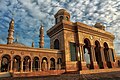 Islamic Centre Samarinda
 -
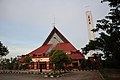 Sangatta Catholic Church
 -
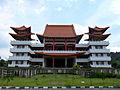 Eka Dharma Manggala Buddhist temple


References
- ^ a b c Badan Pusat Statistik, Jakarta, 2023, Provinsi Kalimantan Timur Dalam Angka 2023 (Katalog-BPS 1102001.64)
- ^ Badan Pusat Statistik (2023). "Produk Domestik Regional Bruto (Milyar Rupiah), 2020–2022" (in Indonesian). Jakarta: Badan Pusat Statistik.
- Badan Pembangunan Nasional (2023). "Capaian Indikator Utama Pembangunan"(in Indonesian). Jakarta: Badan Pembangunan Nasional.
- ^ a b Biro Pusat Statistik, Jakarta, 2011.
- ^ a b Badan Pusat Statistik, Jakarta, 2021.
- ^ revised area following the removal of Tarakan city and four regencies to form the new North Kalimantan province in 2012, and subsequently amended by BPS.
- ^ Badan Pusat Statistik. "Hasil Sensus Penduduk 2010 Data Agregat Per Provinsi" (PDF). Badan Pusat Statistik. Archived from the original (PDF) on 13 November 2010.
- ^ "Organisasi". Kaltimprov.go.id. Archived from the original on 15 January 2013. Retrieved 13 January 2013.
- ^ "Indonesia minister announces name of new national capital in eastern Kalimantan". Channel News Asia.
- ^ a b Zimmer, Carl (7 November 2018). "In Cave in Borneo Jungle, Scientists Find Oldest Figurative Painting in the World – A cave drawing in Borneo is at least 40,000 years old, raising intriguing questions about creativity in ancient societies". The New York Times. Retrieved 8 November 2018.
- S2CID 53208538.
- ^ Delbecq, Denis (7 November 2018). "A Bornéo, des fresques parmi les plus anciennes du monde ont été découvertes". Le Temps (in French). Retrieved 8 November 2018.
- S2CID 53208538.
- ^ Gabbatiss, Josh (8 November 2018). "Oldest ever figurative painting discovered in Borneo cave". The Independent. Retrieved 9 November 2018.
- ^ Weule, Genelle (8 November 2018). "Scientists say this is the world's oldest known animal rock art". ABC News. Retrieved 8 November 2018.
- S2CID 53208538. Retrieved 8 November 2018.
- ^ Reading Song-Ming Records on the Pre-colonial History of the Philippines By Wang Zhenping Page 258.
- ^ "Provinsi Kalimantan Utara Diresmikan 15 April". 22 March 2013.
- ^ "Badan Pusat Statistik".
- ^ http://www.panda.org/heart-of-borneo/ WWF Heart of Borneo conservation initiative – orang-utan, rhinoceros and pygmy elephant cling for survival.
- ^ "Home". sambojalodge.com.
- ^ "Provinsi Kalimantan Timur Dalam Angka 2023". Statistics Indonesia. Retrieved 22 September 2023.
- ^ "Post-Era of Natural Resources Development in East Kalimantan | GEOTIMES". GEOTIMES. 22 September 2017. Retrieved 15 November 2018.
- ^ "East Kalimantan's Economy Still Heavily Relies on Coal Price". Retrieved 15 November 2018.
- ^ "Expedition Magazine | Agriculture in Interior Borneo". www.penn.museum. Retrieved 15 November 2018.
- ^ Tarahita, Dikanaya; Rakhmat, Muhammad Zulfikar. "Solving Indonesia's Infrastructure Gap". The Diplomat. The Diplomat. Retrieved 15 November 2018.
- ^ "The Mighty Mahakam River [with PHOTOS] – INDONEO". Indoneo. Retrieved 15 November 2018.
- ^ "Russian firm signs MoU to build $2.4 billion railway". 8 February 2012.
- ^ ISBN 0-89181-306-3, p. 401
- ISBN 0-89181-306-3, p. 441
- ISBN 0-89181-306-3, p. 459
- ^ "BPS -". Kaltim.bps.go.id. Archived from the original on 23 November 2012. Retrieved 17 November 2012.
- ^ "Tiga dari 16 Bahasa Daerah di Kaltim Nyaris Punah, Satu Diantaranya Bahasa Paser". pusaranmedia.com. Retrieved 22 September 2023.
- ^ "Jumlah Penduduk Menurut Agama" (in Indonesian). Ministry of Religious Affairs. 31 August 2022. Retrieved 29 October 2023.
Regencies and cities of East Kalimantan | ||
|---|---|---|
Capital: Samarinda | ||
| Regencies |
| |
| Cities | ||
| Towns and villages | ||
| Sumatra |  | |
|---|---|---|
| Java | ||
| Kalimantan | ||
| Lesser Sunda Islands | ||
| Sulawesi | ||
| Maluku Islands | ||
| Western New Guinea | ||
| Former provinces |
| |
| Political divisions | |
|---|---|
| Ecoregions | |
| Environment | |
| History | |
| Ethnic groups | |
| Languages | |
| International | |
|---|---|
| National | |