
East Prussia
| East Prussia Ostpreußen | |||||||||||||||||||
|---|---|---|---|---|---|---|---|---|---|---|---|---|---|---|---|---|---|---|---|
| Province of Prussia | |||||||||||||||||||
| 1773–1829 1878–1945 | |||||||||||||||||||
 Flag
 Coat of arms
| |||||||||||||||||||
East Prussian | |||||||||||||||||||
| Area | |||||||||||||||||||
• 1905 | 36,993 km2 (14,283 sq mi) | ||||||||||||||||||
| Population | |||||||||||||||||||
• 1905 | 2,030,174 | ||||||||||||||||||
| History | |||||||||||||||||||
| 31 January 1773 | |||||||||||||||||||
• Province of Prussia | 3 December 1829 | ||||||||||||||||||
• Province restored | 1 April 1878 | ||||||||||||||||||
| 1 August 1945 | |||||||||||||||||||
| Political subdivisions | Gumbinnen Königsberg Allenstein (from 1905) West Prussia (1922–1939) Zichenau (from 1939) | ||||||||||||||||||
| |||||||||||||||||||
| Today part of | Poland Lithuania Russia (Kaliningrad Oblast) | ||||||||||||||||||
East Prussia[Note 1] was a province of the Kingdom of Prussia from 1773 to 1829 and again from 1878 (with the Kingdom itself being part of the German Empire from 1871); following World War I it formed part of the Weimar Republic's Free State of Prussia, until 1945. Its capital city was Königsberg (present-day Kaliningrad). East Prussia was the main part of the region of Prussia along the southeastern Baltic Coast.[1]
The bulk of the ancestral lands of the Baltic
Because the duchy was outside of the core Holy Roman Empire, the prince-electors of Brandenburg were able to proclaim themselves King beginning in 1701. After the annexation of most of western Royal Prussia in the First Partition of the Polish–Lithuanian Commonwealth in 1772, eastern (ducal) Prussia was connected by land with the rest of the Prussian state and was reorganized as a province the following year. Between 1829 and 1878, the Province of East Prussia was joined with West Prussia to form the Province of Prussia.
The
Background

At the instigation of Duke
The Teutonic Order lost eastern Prussia when Grand Master
The Administrator of Prussia, the grandmaster of the Teutonic Order
History as a province
Kingdom of Prussia
Although Brandenburg was a part of the Holy Roman Empire, the Prussian lands were not within the Holy Roman Empire and were with the administration by the Teutonic Order grandmasters under jurisdiction of the Emperor. In return for supporting Emperor Leopold I in the War of the Spanish Succession, Elector Frederick III was allowed to crown himself "King in Prussia" in 1701. The new kingdom ruled by the Hohenzollern dynasty became known as the Kingdom of Prussia. The designation "Kingdom of Prussia" was gradually applied to the various lands of Brandenburg-Prussia. To differentiate it from the larger entity, the former Duchy of Prussia became known as Altpreußen ("Old Prussia"), the province of Prussia, or "East Prussia".
Approximately one-third of East Prussia's population died in the

In the 1772 First Partition of Poland, the Prussian king Frederick the Great annexed neighboring Royal Prussia, i.e., the Polish voivodeships of Pomerania (Gdańsk Pomerania or Pomerelia), Malbork, Chełmno and the Prince-Bishopric of Warmia, thereby connecting his Prussian and Farther Pomeranian lands and cutting the rest of Poland from the Baltic coast. The territory of Warmia was incorporated into the lands of former Ducal Prussia, which, by administrative deed of 31 January 1772 were named East Prussia. The former Polish Pomerelian lands beyond the Vistula River together with Malbork and Chełmno Land formed the Province of West Prussia with its capital at Marienwerder (Kwidzyn) in 1773. The Polish Partition Sejm ratified the cession on 30 September 1772, whereafter Frederick officially went on to call himself a King "of" Prussia.
The former Ducal Prussian
- German chamber department at Königsberg with the districts of:
- Brandenburg
- Neidenburg
- Rastenburg
- Samland
- Tapiau
- Braunsberg (Ermland)
- Heilsberg (Ermland)
- Mohrungen (Ermland)
- Lithuanian chamber department at Gumbinnen (Gusev) with the districts of:
On 31 January 1773, King
Napoleonic Wars

After the disastrous defeat of the
The succeeding Prussian reforms instigated by Heinrich Friedrich Karl vom und zum Stein and Karl August von Hardenberg included the implementation of an Oberlandesgericht appellation court at Königsberg, a municipal corporation, economic freedom as well as emancipation of the serfs and Jews. In the course of the Prussian restoration by the 1815 Congress of Vienna, the East Prussian territories were re-arranged in the Regierungsbezirke of Gumbinnen and Königsberg. From 1905, the southern districts of East Prussia formed the separate Regierungsbezirk of Allenstein. East and West Prussia were first united in personal union in 1824 and then merged in a real union in 1829 to form the Province of Prussia. The united province was again split into separate East and West Prussian provinces in 1878.

German Empire
From 1824 to 1878, East Prussia was combined with West Prussia to form the Province of Prussia, after which they were reestablished as separate provinces. Along with the rest of the Kingdom of Prussia, East Prussia became part of the German Empire during the unification of Germany in 1871.
From 1885 to 1890
The population of the province in 1900 was 1,996,626 people, with a religious makeup of 1,698,465
World War I
At the
After the Russian army's first invasion the majority of the civilian population fled westwards, while several thousand remaining civilians were deported to Russia. Treatment of civilians by both armies was mostly disciplined, although 74 civilians were killed by Russian troops in the Abschwangen massacre. The region had to be rebuilt because of damage caused by the war.
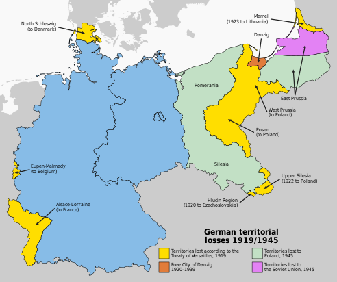
Division after 1918
| East Prussia | Area in 1910 in km2 | Share of territory | Population in 1910 | After WW1 part of: | Notes |
|---|---|---|---|---|---|
| Given to: | 37,002 km2 [13] | 100% | 2,064,175 | Divided between: | |
| Poland | 565 km2 [14][15] | 2% | 2% | Pomeranian Voivodeship (Działdowo area)[citation needed] |
[Note 2] |
| Lithuania | 2,828 km2 | 8% | 7% | Klaipėda Region | |
| East Prussia | 33,609 km2 | 90% | 91% | East Prussia |
Weimar Republic

With the forced abdication of Emperor
On 11 July 1920, amidst the backdrop of the
The Klaipėda Territory (Memelland), a League of Nations mandate since 1920, was occupied by the Lithuanian Armed Forces in 1923 and annexed without giving the inhabitants a choice by ballot.
Nazi Germany

After
In the March 1933 German federal election, the last contested pre-war German election, the local population of East Prussia voted overwhelmingly for the Adolf Hitler's Nazi Party.
Through publicly funded emergency relief programs concentrating on agricultural land-improvement projects and road construction, the "Erich Koch Plan" for East Prussia allegedly made the province free of
In 1938 the
After the
World War II


After the 1939 invasion of Poland by Nazi Germany opening World War II, the borders of East Prussia were revised. Regierungsbezirk Westpreußen became part of Reichsgau Danzig-West Prussia, while Regierungsbezirk Zichenau (Ciechanów) was added to East Prussia. Originally part of the Zichenau region, the Sudauen (Suwałki) district in Sudovia was later transferred to the Gumbinnen region. In 1939 East Prussia had 2.49 million inhabitants, 85% of them ethnic Germans, the others
During
In 1939 the
Germany operated the Soldau and Hohenbruch concentration camps, mostly for Poles, multiple subcamps of the Stutthof concentration camp and several prisoner-of-war camps, including Stalag I-A, Stalag I-B, Stalag I-C, Stalag I-D, Stalag I-E, Stalag I-F, Stalag Luft VI, Oflag 52, Oflag 53, Oflag 60, Oflag 63 and Oflag 68 with multiple subcamps, for Polish, Belgian, French, British, Serbian, Soviet, Italian, American, Canadian, Australian, New Zealander, South African, Czech and other Allied POWs in the province.[30]
Hitler's top-secret Eastern front headquarters during the war, the Wolf's Lair, was located in the village of Gierłoż.
East Prussia was only slightly affected by the war until January 1945, when it was devastated during the
Evacuation of East Prussia

In 1944 the medieval city of
Gauleiter Erich Koch delayed the evacuation of the German civilian population until the Eastern Front approached the East Prussian border in 1944. The population had been systematically misinformed by Endsieg Nazi propaganda about the real state of military affairs. As a result, many civilians fleeing westward were overtaken by retreating Wehrmacht units and the rapidly advancing Red Army.
Reports of Soviet atrocities in the
However, most of the German inhabitants, which then consisted primarily of women, children and old men, did manage to escape the Red Army as part of the largest exodus of people in human history: "A population which had stood at 2.2 million in 1940 was reduced to 193,000 at the end of May 1945."[31][32]
History after partition and annexation
Following
Expulsion of Germans from East Prussia after World War II
Shortly after the end of the war in May 1945, Germans who had fled in early 1945 tried to return to their homes in East Prussia. An estimated number of 800,000 Germans were living in East Prussia during the summer of 1945.
-
 An illustration of the changing borders inGerman.)
 -
 Changes inWorld Wars, with the partition of East Prussia


Southern East Prussia to Poland
Representatives of the Polish government officially took over the civilian administration of the southern part of East Prussia on 23 May 1945.
The remaining pre-war population was treated as Germanized Poles and a policy of re-
Origin of the post-war population
During the Polish post-war census of December 1950, data about the pre-war places of residence of the inhabitants as of August 1939 was collected. In case of children born between September 1939 and December 1950, their origin was reported based on the pre-war places of residence of their mothers. Thanks to this data it is possible to reconstruct the pre-war geographical origin of the post-war population. The same area corresponding to pre-war southern parts of East Prussia (which became Polish in 1945) was inhabited in December 1950 by:
| Region (within 1939 borders): | Number | Percent |
|---|---|---|
| Autochthons (1939 DE/FCD citizens) | 134,702 | 15.90% |
| Polish expellees from Kresy (USSR) | 172,480 | 20.36% |
| Poles from abroad except the USSR | 5,734 | 0.68% |
| Resettlers from the City of Warsaw
|
22,418 | 2.65% |
| From Warsaw region (Masovia) | 158,953 | 18.76% |
| From Białystok region and Sudovia | 102,634 | 12.11% |
| From pre-war Polish Pomerania | 83,921 | 9.90% |
| Resettlers from Poznań region
|
7,371 | 0.87% |
| Katowice region ( East Upper Silesia )
|
2,536 | 0.30% |
| Resettlers from the City of Łódź | 1,666 | 0.20% |
| Resettlers from Łódź region | 6,919 | 0.82% |
| Resettlers from Kielce region | 20,878 | 2.46% |
| Resettlers from Lublin region | 60,313 | 7.12% |
| Resettlers from Kraków region | 5,515 | 0.65% |
| Resettlers from Rzeszów region
|
47,626 | 5.62% |
| place of residence in 1939 unknown | 13,629 | 1.61% |
| Total pop. in December 1950 | 847,295 | 100.00% |
Over 80% of the 1950 inhabitants were new in the region, less than 20% had resided in the province already back in 1939 (so called autochthons, who had German citizenship before World War II and were granted Polish citizenship after 1945). Over 20% of all inhabitants were Poles expelled from areas of Eastern Poland annexed by the USSR. The rest were mostly people from neighbouring areas located right next to East Prussia (almost 44% came from Masovia, Sudovia, Podlachia and pre-war Polish Pomerania) and southern Poland (≈16%).
Northern part to the Soviet Union


In April 1946, northern East Prussia became an official province of the
The Prussian Lithuanians also experienced the same fate.
A similar fate befell the
After the expulsion of the German population ethnic Russians, Belarusians, and Ukrainians were settled in the northern part. In the Soviet part of the region, a policy of eliminating all remnants of German history was pursued. All German place names were replaced by new Russian names. The exclave was a military zone, which was closed to foreigners; Soviet citizens could only enter with special permission. In 1967 the remnants of Königsberg Castle were demolished on the orders of Leonid Brezhnev to make way for a new "House of the Soviets".
Modern status
Although the 1945–1949 expulsion of Germans from the northern part of former East Prussia was often conducted in a violent and aggressive way by Soviet officials, the present Russian inhabitants of the Kaliningrad Oblast have much less animosity towards Germans. German names have been revived in commercial Russian trade and there is sometimes talk of reverting Kaliningrad's name to its historical name of Königsberg. The city centre of Kaliningrad was completely rebuilt, as Royal Air Force bombs in 1944 and the Soviet siege in 1945 had left it in ruins.
Since the dissolution of the Soviet Union in 1991, some German groups have tried to help settle the Volga Germans from eastern parts of European Russia in the Kaliningrad Oblast. This effort was only a minor success, however, as most impoverished Volga Germans preferred to emigrate to the richer Federal Republic of Germany, where they could become German citizens through the right of return.
The Polish part of the region, divided in 1975 to form three units: the Olsztyn Voivodeship, the
Demographics
Historical ethnic and religious structure

In year 1824, shortly before its
In year 1817, East Prussia had 796,204
Ethnolinguistic composition by district

As of 1905, the province of East Prussia was divided into three government regions, known as Regierungsbezirke. These were the regions of Königsberg, Gumbinnen and Allenstein.
| District (Kreis) | Regierungsbezirk | Population | German | % | Polish | % | Lithuanian | % |
|---|---|---|---|---|---|---|---|---|
| Braunsberg | Königsberg | 54,751 | 54,548 | 99.6% | 140 | 0.3% | 12 | 0.0% |
| Fischhausen | Königsberg | 52,430 | 52,235 | 99.6% | 90 | 0.2% | 43 | 0.1% |
| Friedland | Königsberg | 40,822 | 40,784 | 99.9% | 14 | 0.0% | 5 | 0.0% |
| Gerdauen | Königsberg | 33,983 | 33,778 | 99.4% | 146 | 0.4% | 1 | 0.0% |
| Heiligenbeil | Königsberg | 43,951 | 43,909 | 99.9% | 21 | 0.0% | 2 | 0.0% |
| Heilsberg | Königsberg | 51,690 | 51,473 | 99.6% | 124 | 0.2% | 8 | 0.0% |
| Landkreis Königsberg | Königsberg | 45,486 | 45,342 | 99.7% | 72 | 0.2% | 12 | 0.0% |
| Stadtkreis Königsberg | Königsberg | 223,770 | 221,167 | 98.8% | 594 | 0.3% | 159 | 0.1% |
| Labiau | Königsberg | 51,295 | 45,659 | 89.0% | 27 | 0.1% | 5,293 | 10.3% |
| Memel | Königsberg | 61,018 | 33,508 | 54.9% | 40 | 0.1% | 26,328 | 43.1% |
| Mohrungen | Königsberg | 52,408 | 52,215 | 99.6% | 113 | 0.2% | 2 | 0.0% |
| Preußisch Eylau | Königsberg | 49,465 | 49,325 | 99.7% | 91 | 0.2% | 3 | 0.0% |
| Preußisch Holland | Königsberg | 38,599 | 38,505 | 99.8% | 61 | 0.2% | 4 | 0.0% |
| Rastenburg | Königsberg | 46,985 | 45,998 | 97.9% | 723 | 1.5% | 19 | 0.0% |
| Wehlau | Königsberg | 46,774 | 46,401 | 99.2% | 178 | 0.4% | 81 | 0.2% |
| Total (Königsberg) | Königsberg | 893,427 | 854,847 | 95.7% | 2,434 | 0.3% | 31,972 | 3.6% |
| Angerburg | Gumbinnen | 35,945 | 34,273 | 95.3% | 1,499 | 4.2% | 39 | 0.1% |
| Darkehmen | Gumbinnen | 32,285 | 32,137 | 99.5% | 74 | 0.2% | 17 | 0.1% |
| Goldap | Gumbinnen | 43,829 | 42,891 | 97.9% | 436 | 1.0% | 185 | 0.4% |
| Gumbinnen | Gumbinnen | 50,918 | 50,703 | 99.6% | 21 | 0.0% | 21 | 0.0% |
| Heydekrug | Gumbinnen | 43,268 | 19,124 | 44.2% | 35 | 0.1% | 23,279 | 53.8% |
| Landkreis Insterburg | Gumbinnen | 46,237 | 45,693 | 98.8% | 68 | 0.1% | 311 | 0.7% |
| Stadtkreis Insterburg | Gumbinnen | 28,902 | 28,412 | 98.3% | 166 | 0.6% | 62 | 0.2% |
| Niederung | Gumbinnen | 55,129 | 47,792 | 86.7% | 47 | 0.1% | 6,497 | 11.8% |
| Oletzko | Gumbinnen | 38,536 | 24,575 | 63.8% | 12,451 | 32.3% | 8 | 0.0% |
| Pilkallen | Gumbinnen | 46,230 | 41,982 | 90.8% | 65 | 0.1% | 3,668 | 7.9% |
| Ragnit | Gumbinnen | 54,741 | 45,525 | 83.2% | 80 | 0.1% | 8,394 | 15.3% |
| Stallupönen | Gumbinnen | 43,875 | 43,099 | 98.2% | 90 | 0.2% | 383 | 0.9% |
| Landkreis Tilsit | Gumbinnen | 46,441 | 25,322 | 54.5% | 38 | 0.1% | 20,674 | 44.5% |
| Stadtkreis Tilsit | Gumbinnen | 37,148 | 35,598 | 95.8% | 37 | 0.1% | 1,442 | 3.9% |
| Total (Gumbinnen) | Gumbinnen | 603,484 | 517,126 | 85.7% | 15,107 | 2.5% | 64,980 | 10.8% |
| Allenstein | Allenstein | 85,625 | 45,723 | 53.4% | 38,701 | 45.2% | 21 | 0.0% |
| Johannisburg | Allenstein | 50,452 | 13,651 | 27.1% | 35,433 | 70.2% | 5 | 0.0% |
| Lötzen | Allenstein | 41,609 | 21,997 | 52.9% | 16,877 | 40.6% | 27 | 0.1% |
| Lyck | Allenstein | 55,790 | 23,562 | 42.2% | 30,555 | 54.8% | 2 | 0.0% |
| Neidenburg | Allenstein | 57,325 | 16,304 | 28.4% | 38,690 | 67.5% | 5 | 0.0% |
| Ortelsburg | Allenstein | 69,464 | 17,221 | 24.8% | 50,665 | 72.9% | 58 | 0.1% |
| Osterode | Allenstein | 73,421 | 39,778 | 54.2% | 33,129 | 45.1% | 13 | 0.0% |
| Rößel | Allenstein | 50,390 | 42,555 | 84.5% | 7,383 | 14.7% | 15 | 0.0% |
| Sensburg | Allenstein | 49,187 | 21,960 | 44.6% | 25,381 | 51.6% | 13 | 0.0% |
| Total (Allenstein) | Allenstein | 533,263 | 242,751 | 45.5% | 276,814 | 51.9% | 159 | 0.0% |
| Total (East Prussia) | - | 2,030,174 | 1,614,724 | 79.5% | 294,355 | 14.5% | 97,111 | 4.8% |
Administration
The Prussian central government appointed for every province an Oberpräsident ("Upper President") carrying out central prerogatives on the provincial level and supervising the implementation of central policy on the lower levels of administration.
Since 1875, with the strengthening of self-rule, the urban and rural
Upper Presidents of East Prussia and Prussia
- 1765–1791: Gumbinnen and KönigsbergWar and Demesnes Chambers
- 1791–1808: Friedrich Leopold von Schrötter, president of the Gumbinnen and Königsberg War and Demesnes Chambers, as of 1795 Minister for East and New East Prussia
- 1808–1814: vacancy?
- 1814–1824: Hans Jakob von Auerswald, upper president of East Prussia
- 1824–1842: Heinrich Theodor von Schön, upper president of Prussia, merged from East and West Prussia, since 1816 already upper president of West Prussia
- 1842–1848: Carl Wilhelm von Bötticher, upper president of Prussia
- 1848–1849: Rudolf von Auerswald, upper president of Prussia
- 1849–1850: Eduard Heinrich von Flottwell (1786–1865), upper president of Prussia
- 1850–1868: Franz August Eichmann, upper president of Prussia
- 1868–1869: vacancy
- 1869–1882: Carl Wilhelm Heinrich Georg von Horn, upper president of Prussia, after 1878 of East Prussia
- 1882–1891: Albrecht Heinrich von Schlieckmann, upper president of East Prussia
- 1891–1895: Count Udo zu Stolberg-Wernigerode, upper president of East Prussia
- 1895–1901: Count Wilhelm von Bismarck-Schönhausen, upper president of East Prussia
- 1901–1903: Hugo Samuel von Richthofen, upper president of East Prussia
- 1903–1907: Count Friedrich von Moltke, upper president of East Prussia
- 1907–1914: Ludwig von Windheim, upper president of East Prussia
- 1914–1916: Adolf Tortilowicz von Batocki-Friebe, upper president of East Prussia
- 1916–1918: Friedrich von Berg, upper president of East Prussia
- 1918–1919: Adolf Tortilowicz von Batocki-Friebe, upper president of East Prussia
- 1919–1920: August Winnig (SPD), upper president of East Prussia
- 1920–1932: Ernst Siehr (DDP), upper president of East Prussia
- 1932–1933: Wilhelm Kutscher (DNVP), upper president of East Prussia
- 1933–1945: Erich Koch (NSDAP), upper president of East Prussia
Elections to the provincial diets
| Parties | % 1921 |
+/- 1921 |
Seats 1921 |
+/- 1921 |
% 1925 |
+/- 1925 |
Seats 1925 |
+/- 1925 |
% 1929 |
+/- 1929 |
Seats 1929 |
+/- 1929 |
% 1933 |
+/- 1933 |
Seats 1933 |
+/- 1933 | |
|---|---|---|---|---|---|---|---|---|---|---|---|---|---|---|---|---|---|
| SPD | 24.1 | 20 | 24.8 | +0.7 (-) | 22 | +2 (-4) | 26 | +1.2 | 23 | +1 | 13.6 | -12.4 | 12 | -11 | |||
| USPD | 6 | +6 | merged in SPD | ||||||||||||||
| DNVP[51] | 13.4 | +13.4 | 11 | +11 | 45.6[52] | 40 | (+4) | 31.2 | (+17.8) | 27 | (+16) | 12.7[51] | -18.5 | 11 | -16 | ||
| DVP | 3.6 | +3.6 | 4 | +4 | 8.7 | (+5.1) | 8 | (+4) | 0 | -8 | |||||||
| BWA | 16 | +16 | 0 | -16 | 0 | 0 | 0 | 0 | |||||||||
| Zentrum | 9.3 | 8 | +8 | 6.9 | -2.4 | 6 | -2 | 8.1 | +1.2 | 7 | +1 | 7 | -1.1 | 7 | 0 | ||
| KPD[53] | 7 | +7 | 6 | +6 | 6.9 | -0.1 | 6 | 0 | 8.6 | +1.7 | 8 | +2 | 6 | -2.6 | 6 | -2 | |
| BWW | 6 | +6 | 0 | -6 | 0 | 0 | 0 | 0 | |||||||||
| Parties | % 1921 |
+/- 1921 |
Seats 1921 |
+/- 1921 |
% 1925 |
+/- 1925 |
Seats 1925 |
+/- 1925 |
% 1929 |
+/- 1929 |
Seats 1929 |
+/- 1929 |
% 1933 |
+/- 1933 |
Seats 1933 |
+/- 1933 | |
| DDP | 5.7 | +5.7 | 6 | +6 | 3.6 | -2.1 | 3 | -3 | 2.8 | -0.8 | 3 | 0 | 0 | -3 | |||
| NSDAP | not run | not run | not run | not run | 4.3 | 4 | +4 | 58.2 | +53,9 | 51 | +47 | ||||||
| LL/WP[54] | 2 | +2 | 4.2 | +4.2 | 4 | +2 | 4 | -1.2 | 4 | 0 | 0 | -4 | |||||
| DFP | not run | not run | not run | not run | 4.2 | +4.2 | 4 | +4 | 0 | -4 | 0 | 0 | |||||
| CSVD | not run | not run | not run | not run | not run | not run | not run | not run | 3 | +3 | 3 | +3 | 0 | -3 | |||
| AuA | not run | not run | not run | not run | 2 | +2 | 0 | -2 | 0 | 0 | |||||||
| FOW | 2 | +2 | 0 | -2 | 0 | 0 | 0 | 0 | |||||||||
| Poles' Party | 1 | +1 | 0 | -1 | 0 | 0 | 0 | 0 | |||||||||
| Others | 2 | +? | 0 | -2 | 0 | 0 | 0 | 0 | |||||||||
| Total 1921 |
85 | Total 1925 |
87 | Total 1929 |
87 | Total 1933 |
87 | ||||||||||
Land Directors and Land Captains of East Prussia
- 1876–1878: ), titled land director
- 1878–1884: Kurt von Saucken-Tarputschen (Fortschritt, later DFP), titled land director
- 1884–1888: Alfred von Gramatzki (DKP), titled land director
- 1888–1896: Klemens von Stockhausen, titled land director
- 1896–1909: Rudolf von Brandt, titled land captain
- 1909–1916: Friedrich von Berg, titled land captain
- 1916–1928: Manfred Graf von Brünneck-Bellschwitz, titled land captain
- 1928–1936: Paul Blunk, titled land captain
- 1936–1941: NSDAP), titled land captain
- 1941–1945: vacancy
- 1941–1945: Reinhard Bezzenberger, first land councillor, per pro
Cities and towns
| City/Town | District (Kreis) | Pop. in 1939 | Current Name | Current Administrative Unit |
|---|---|---|---|---|
Allenburg |
Landkreis Wehlau | 2 694 | Druzhba |
Kaliningrad Oblast (Russia) |
Allenstein |
Landkreis Allenstein | 50 396 | Olsztyn | Warmian-Masurian Voivodeship (Poland )
|
Angerburg |
Landkreis Angerburg | 10 922 | Węgobork ) |
Warmia-Masuria |
| Arys | Landkreis Johannisburg | 3 553 | Orzysz | Warmia-Masuria |
| Barten | Rastenburg | 1 541 | Barciany | Warmia-Masuria |
Bartenstein |
Landkreis Bartenstein | 12 912 | Bartoszyce | Warmia-Masuria |
Bischofsburg |
Landkreis Rößel | Biskupiec | Warmia-Masuria | |
| Bischofstein (Ostpreußen) | Rößel | 3 200 | Bisztynek | Warmia-Masuria |
Braunsberg |
Landkreis Braunsberg | 21 142 | Braniewo | Warmia-Masuria |
Darkehmen/Angerapp |
Darkehmen | Ozyorsk | Kaliningrad | |
Domnau |
Bartenstein | Domnovo | Kaliningrad | |
Elbing |
Stadtkreis | 85 952 | Elbląg | Warmia-Masuria |
Eydtkuhnen |
Landkreis Stallupönen | 4 922 | Chernyshevskoye | Kaliningrad |
Fischhausen |
Landkreis Samland | 3 879 | Primorsk | Kaliningrad |
Frauenburg (Ostpreußen) |
Braunsberg | 2 951 | Frombork | Warmia-Masuria |
Friedland (Ostpreußen) |
Bartenstein | Pravdinsk | Kaliningrad | |
Gehlenburg |
Johannisburg | Biała Piska | Warmia-Masuria | |
Gerdauen |
Landkreis Gerdauen | 5 118 | Zheleznodorozhny | Kaliningrad |
Gilgenburg |
Landkreis Osterode | 1 700 | Dąbrówno | Warmia-Masuria |
Goldap |
Landkreis Goldap | 12 786 | Gołdap | Warmia-Masuria |
Gumbinnen |
Landkreis Gumbinnen | 24 534 | Gusev | Kaliningrad |
Guttstadt |
Landkreis Heilsberg | Dobre Miasto | Warmia-Masuria | |
| Heiligenbeil | Landkreis Heiligenbeil | 12 100 | Mamonovo | Kaliningrad |
| Heilsberg | Kreis Heilsberg | Lidzbark Warmiński | Warmia-Masuria | |
| Heydekrug | Landkreis Heydekrug | 4 836 | Šilutė | Klaipėda County (Lithuania) |
Hohenstein |
Osterode | Olsztynek | Warmia-Masuria | |
Insterburg |
Landkreis Insterburg | 48 711 | Chernyakhovsk | Kaliningrad |
Johannisburg |
Johannisburg | Pisz (Jańsbork) | Warmia-Masuria | |
Königsberg (Preußen) |
Stadtkreis | 372 000 | Kaliningrad | Kaliningrad |
| Kreuzburg (Ostpreußen) | Landkreis Preußisch Eylau | Slavskoye | Kaliningrad | |
Labiau |
Landkreis Labiau | 6 527 | Polessk | Kaliningrad |
Landsberg in Ostpreußen |
Preußisch Eylau | Górowo Iławeckie | Warmia-Masuria | |
Liebemühl |
Osterode | Miłomłyn | Warmia-Masuria | |
| Liebstadt | Mohrungen | 2 742 | Miłakowo | Warmia-Masuria |
Lötzen |
Landkreis Lötzen | 13 000 | Giżycko (Lec) | Warmia-Masuria |
Lyck |
Landkreis Lyck | 16 482 | Ełk (Łęg) | Warmia-Masuria |
Treuburg |
Landkreis Oletzko/Treuburg | Olecko | Warmia-Masuria | |
Marienburg in Westpreußen |
Marienburg | Malbork | Pomeranian Voivodeship (Poland) | |
Mehlsack |
Braunsberg | Melzak ) |
Warmia-Masuria | |
| Memel | Stadtkreis | 41 297 | Klaipėda | Klaipėda |
Mohrungen |
Mohrungen | 5 500 | Morąg | Warmia-Masuria |
| Mühlhausen | Landkreis Preußisch Holland | Młynary | Warmia-Masuria | |
Neidenburg |
Landkreis Neidenburg | 9 201 | Nidzica (Nibork) | Warmia-Masuria |
Nikolaiken |
Landkreis Sensburg | Mikołajki | Warmia-Masuria | |
| Nordenburg | Gerdauen | 3 173 | Krylovo | Kaliningrad |
Ortelsburg |
Landkreis Ortelsburg | 14 234 | Szczytno | Warmia-Masuria |
Osterode (Ostpreußen) |
Osterode | 19 519 | Ostróda | Warmia-Masuria |
Passenheim |
Ortelsburg | 2 431 | Pasym | Warmia-Masuria |
Peterswalde |
Osterode | Piertzwald | Warmia-Masuria | |
Pillau |
Samland | 12 000 | Baltiysk | Kaliningrad |
Preußisch Eylau |
Preußisch Eylau | 7 485 | Bagrationovsk | Kaliningrad |
Preußisch Holland |
Preußisch Holland | Pasłęk | Warmia-Masuria | |
Ragnit |
Landkreis Tilsit-Ragnit | 10 094 | Neman |
Kaliningrad |
Rastenburg |
Rastenburg | 19 634 | Rastembork ) |
Warmia-Masuria |
Rhein (Ostpreußen) |
Lötzen | Ryn | Warmia-Masuria | |
Rößel |
Rößel | 5 000 | Reszel | Warmia-Masuria |
| Saalfeld | Mohrungen | Zalewo | Warmia-Masuria | |
Schippenbeil |
Bartenstein | Sępopol | Warmia-Masuria | |
Schirwindt |
Landkreis Pillkallen | Kutuzovo |
Kaliningrad | |
| Pillkallen-Schlossberg | Pillkallen | Dobrovolsk | Kaliningrad | |
| Seeburg | Rößel | Zybork ) |
Warmia-Masuria | |
Sensburg |
Sensburg | Żądzbork ) |
Warmia-Masuria | |
Soldau |
Neidenburg | 5 349 | Działdowo | Warmia-Masuria |
Stallupönen |
Stallupönen | 6 608 | Nesterov | Kaliningrad |
Tapiau |
Wehlau | 9 272 | Gvardeysk | Kaliningrad |
Tilsit |
Stadtkreis | 59 105 | Sovetsk | Kaliningrad |
Wartenburg (Ostpreußen) |
Landkreis Allenstein | 5 841 | Wartembork ) |
Warmia-Masuria |
Wehlau |
Wehlau | 7 348 | Znamensk | Kaliningrad |
| Willenberg | Ortelsburg | 2 600 | Wielbark |
Warmia-Masuria |
Wormditt |
Braunsberg | Orneta | Warmia-Masuria | |
| Zinten | Heiligenbeil | Kornevo |
Kaliningrad |
See also
Explanatory notes
- ^ German: Ostpreußen [ˈɔstˌpʁɔɪ̯sn̩] ⓘ; Low Prussian: Ostpreißen; Polish: Prusy Wschodnie; Lithuanian: Rytų Prūsija
- ^ Part of pre-1918 county Nidzica with Działdowo and with around 27 thousand inhabitants;[14] as well as parts of county Ostróda near Dąbrówno, with areas around Groszki, Lubstynek, Napromek, Czerlin, Lewałd Wielki, Grzybiny and with around 4786 inhabitants.[16] Too small to form its own voivodeship, this territory was incorporated into the interwar Pomeranian Voivodeship.
Citations
- ^ The Columbia Encyclopedia, Sixth Edition (2008), East Prussia
- ^ Schaitberger, L. "Ostpreußen: The Great Trek". Retrieved 8 December 2016.
- ^ Encyclopædia Britannica: Old-Prussian-language; Gordon, Raymond G., Jr. (ed.): Ethnologue: Languages of the World, 2005, Prussian
- ^ [email protected]. "Sarmatian Review XV.1: Davies". Retrieved 8 December 2016.
- ^ a b Andreas Kossert, Ostpreußen. Geschichte und Mythos, 2007 Pantheon Verlag, PDF edition, p. 342. According to Kossert East Prussia lost about 511,000 out of 2,490,000 inhabitants, thereof 311,000 civilians.
- ^ Górski, Karol (1949). Związek Pruski i poddanie się Prus Polsce: zbiór tekstów źródłowych (in Polish). Poznań: Instytut Zachodni. pp. XXXI, XXXVII–XXXVIII.
- ^ Górski, p. 54
- ^ Górski, pp. 88–90, 99, 206–207, 217
- ^ Górski, pp. 96–97, 214–215
- ^ A Treatise on Political Economy
- ^ "LINGUISTIC PRINCIPLES OF THE RECOVERY OF OLD PRUSSIAN". Retrieved 8 December 2016.
- ^ Ethnic Groups and Population Changes in Twentieth-Century Central-Eastern Europe: History, Data, and Analysis. Piotr Eberhardt,page 166, 2003 M E Sharpe Inc
- ^ "Gemeindeverzeichnis Deutschland".
- ^ a b Rocznik statystyki Rzeczypospolitej Polskiej 1920/21, 1921
- ^ Jehke, Rolf. "Rbz. Allenstein: 10.1.1920 Abtretung des Kreises Neidenburg (teilweise) an Polen; 15.8.1920 Abtretung der Landgemeinden Groschken, Groß Lehwalde (teilweise), Klein Lobenstein (teilweise), Gut Nappern und der Gutsbezirke Groß Grieben (teilweise) und Klein Nappern (teilweise) an Polen". territorial.de.
- ISBN 3-16-148403-7.
- ^ Matull, page 357
- ^ a b Robert S. Wistrich, Who's who in Nazi Germany, 2002, pp. 142-143.
- ^ Matull, Wilhelm (1973). "Ostdeutschlands Arbeiterbewegung: Abriß ihrer Geschichte, Leistung und Opfer" (PDF) (in German). Holzner Verlag. p. 350.
- ^ Die aufrechten Roten von Königsberg Spiegel.de, 28 June 2009 (in German)
- S2CID 143888997.
- ^ Tooze 2006, p. 44-45.
- ^ Richard Steigmann-Gall, The Holy Reich - Nazi Conceptions of Christianity 1919-1945, 2004, p. 102.
- ISBN 978-3-86153-433-4.
- ^ Szkolnictwo polskie w Niemczech 1919-1939, Henryk Chałupczak Wydawnictwo Uniwersytetu Marii Curie-Skłodowskiej,page9 1996
- ^ S. Achremczyk: Warmia, Olsztyn 2000.
- ^ S. Achremczyk: Historia Warmii i Mazur, Olsztyn 1997
- ISBN 978-1-935149-20-0.
- ^ Rademacher, Michael. "Deutsche Verwaltungsgeschichte Preußen, Provinz Ostpreußen 1871 - 1945". Archived from the original on 30 December 2016. Retrieved 8 December 2016.
- ISBN 978-0-253-06089-1.
- ISBN 0-670-88695-5
- ISBN 0-670-88695-5
- ISBN 9780880331746.
- ISBN 978-3-421-04366-5
- ^ ISBN 0-7425-1094-8.
- ^ Ethnic Germans in Poland and the Czech Republic:A Comparative Evaluation Archived 3 March 2016 at the Wayback Machine by Karl Cordell and Stefan Wolff
- ISBN 3-88680-808-4
- ^ The Polish toponymic guidelines[permanent dead link] (p.9)
- ^ Kosiński, Leszek (1960). "Pochodzenie terytorialne ludności Ziem Zachodnich w 1950 r. [Territorial origins of inhabitants of the Western Lands in year 1950]" (PDF). Dokumentacja Geograficzna (in Polish). 2. Warsaw: PAN (Polish Academy of Sciences), Institute of Geography: Tabela 1 (data by county) – via Repozytorium Cyfrowe Instytutów Naukowych.
- ISBN 978-3-421-04366-5
- ^ Plater, Stanisław (1825). Jeografia wschodniéy części Europy czyli Opis krajów przez wielorakie narody słowiańskie zamieszkanych: obejmujący Prussy, Xsięztwo Poznańskie, Szląsk Pruski, Gallicyą, Rzeczpospolitę Krakowską, Krolestwo Polskie i Litwę (in Polish). Wrocław: u Wilhelma Bogumiła Korna. p. 17.
- ^ Andree, Karl (1831). Polen: in geographischer, geschichtlicher und culturhistorischer Hinsicht (in German). Verlag von Ludwig Schumann. p. 218.
- ^ Hassel, Georg (1823). Statistischer Umriß der sämmtlichen europäischen und der vornehmsten außereuropäischen Staaten, in Hinsicht ihrer Entwickelung, Größe, Volksmenge, Finanz- und Militärverfassung, tabellarisch dargestellt; Erster Heft: Welcher die beiden großen Mächte Österreich und Preußen und den Deutschen Staatenbund darstellt (in German). Verlag des Geographischen Instituts Weimar. p. 41.
- ^ a b Haxthausen, August (1839). Die Ländliche Verfassung in den Einzelnen Provinzen der Preussischen Monarchie (in German). pp. 75–91.
- ^ "Monastery of the Dormition of the Mother of God in Wojnowo (Eckersdorf)". wojnowo.net.
- ^ Tetzner, Franz (1902). Die Slawen in Deutschland: beiträge zur volkskunde der Preussen, Litauer und Letten, der Masuren und Philipponen, der Tschechen, Mährer und Sorben, Polaben und Slowinzen, Kaschuben und Polen. Braunschweig: Verlag von F. Vieweg. pp. 212–248.
- ^ "Old Believers in Poland - historical and cultural information". Poland's Linguistic Heritage. Archived from the original on 23 December 2018. Retrieved 23 December 2018.
- ^ Hoffmann, Johann Gottfried (1818). Übersicht der Bodenfläche und Bevölkerung des Preußischen Staates : aus den für das Jahr 1817 mtlich eingezogenen Nachrichten. Berlin: Decker. p. 51.
- ]
- ^ In some Prussian provinces the same office continued to be called Landesdirektor also thereafter. Cf. article: "Landesdirektor", in: Der Große Brockhaus: Handbuch des Wissens in zwanzig Bänden: 21 vols.; Leipzig: Brockhaus, 151928–1935; vol. 11 (1932), p. 71.
- ^ a b In 1933 the DNVP ran under the list KFSWR, also including Der Stahlhelm and the LB.
- ^ DVP and DNVP formed the united list called Prussian Block (PB, Preußemblock).
- ^ In 1921 the party was named United Communist Party of Germany, VKPD.
- ^ In 1921 the Landliste (LL, Rural List) gained two seats, in 1926 the LL formed a united list with the WP and the East Prussian Farmers' Federation (OBB), in 1929 they all ran as part of the WP.
General bibliography
- Publications in English
- Baedeker, Karl, Northern Germany, 14th revised edition, London, 1904.
- ISBN 0-670-88695-5. Archived from the originalon 5 February 2006. Retrieved 6 May 2006. (on the years 1944/45)
- Alfred-Maurice de Zayas, " Nemesis at Potsdam". London, 1977. ISBN 0-8032-4910-1.
- ISBN 0-312-12159-8
- Carsten, F. L. "East Prussia". History 33#119 (1948), pp. 241–246. JSTOR 24402359. Historiography of medieval and early modern period.
- Dickie, Reverend J.F., with E.Compton, Germany, A & C Black, London, 1912.
- Douglas, R.M.: Orderly and Humane. The Expulsion of the Germans after the Second World War. Yale University Press, 2012. ISBN 978-0300166606.
- von Treitschke, Heinrich, History of Germany - vol.1: The Wars of Emancipation, (translated by E & C Paul), Allen & Unwin, London, 1915.
- Powell, E. Alexander, Embattled Borders, London, 1928.
- Prausser, Steffen and Rees, Arfon: The Expulsion of the "German" Communities from Eastern Europe at the End of the Second World War. Florence, Italy, European University Institute, 2004.
- Naimark, Norman: Fires of Hatred. Ethnic Cleansing in Twentieth-Century Europe. Cambridge, Harvard University Press, 2001.
- Steed, Henry Wickham, Vital Peace - A Study of Risks, Constable & Co., London, 1936.
- Newman, Bernard, Danger Spots of Europe, London, 1938.
- ISBN 0-299-18544-3.
- Woodward, E.L., Butler, Rohan; Medlicott, W.N., Dakin, Douglas, & Lambert, M.E., et al. (editors), Documents on British Foreign Policy 1919-1939, Three Series, Her Majesty's Stationery Office (Versailles Treatyincluding all secret meetings; plebiscites and all other problems in Europe; includes all diplomatic correspondence from all states.
- Previté-Orton, C.W., Professor, The Shorter Cambridge Medieval History, Cambridge University Press, 1952 (2 volumes).
- Balfour, Michael, and John Mair, Four-Power Control in Germany and Austria 1945-1946, Oxford University Press, 1956.
- Kopelev, Lev, To Be Preserved Forever, ("Хранить вечно"), 1976.
- Koch, H.W., Professor, A History of Prussia, ISBN 0-582-48190-2
- Koch, H.W., Professor, A Constitutional History of Germany in the 19th and 20th Centuries, ISBN 0-582-49182-7
- MacDonogh, Giles, Prussia, ISBN 1-85619-267-9
- Nitsch, Gunter, Weeds Like Us, AuthorHouse, 2006, ISBN 978-1-4259-6755-0
- Denny, Isabel (2007). The fall of Hitler's fortress city : the battle of Konigsberg, 1945. Havertown, Penn.: Casemate. OCLC 783289112.
- ISBN 978-0-670-03826-8.
- Publications in German
- B. Schumacher: Geschichte Ost- und Westpreussens, Würzburg 1959
- Boockmann, Hartmut: Ostpreußen und Westpreußen (= Deutsche Geschichte im Osten Europas). Siedler, Berlin 1992, ISBN 3-88680-212-4
- Buxa, Werner and Hans-Ulrich Stamm: Bilder aus Ostpreußen
- Dönhoff, Marion Gräfin v. :Namen die keiner mehr nennt - Ostpreußen, Menschen und Geschichte
- Dönhoff, Marion Gräfin v.: Kindheit in Ostpreussen
- Falk, Lucy: Ich Blieb in Königsberg. Tagebuchblätter aus dunklen Nachkriegsjahren
- Kibelka, Ruth: Ostpreußens Schicksaljahre, 1945-1948
- Bernd, Martin (1998). Masuren, Mythos und Geschichte. Karlsruhe: Evangelische Akademie Baden. ISBN 83-85135-93-6.
- Nitsch, Gunter: "Eine lange Flucht aus Ostpreußen", Ellert & Richter Verlag, 2011, ISBN 978-3-8319-0438-9
- ISBN 3-89426-059-9.
- Publications in French
- Pierre Benoît, Axelle
- Georges Blond, L'Agonie de l'Allemagne
- Michel Tournier, Le Roi des aulnes
- Publications in Polish
- K. Piwarski (1946). Dzieje Prus Wschodnich w czasach nowożytnych. Gdańsk.
{{cite book}}: CS1 maint: location missing publisher (link) - Gerard Labuda, ed. (1969–2003). "Historia Pomorza", vol. I–IV. Poznań.
{{cite book}}: CS1 maint: location missing publisher (link) - collective work (1958–61). "Szkice z dziejów Pomorza", vol. 1–3. Warszawa.
{{cite book}}: CS1 maint: location missing publisher (link) - Andreas Kossert (2009). PRUSY WSCHODNIE, Historia i mit. Warszawa. ISBN 978-83-7383-354-8.)
{{cite book}}: CS1 maint: location missing publisher (link
External links
- Pictures of East Prussia Large archive
- Brandenburg Prince-Electors co-inheritors 1568, co-regent 1577
- East Prussia FAQ
- Extensive East & West Prussian Historical Materials Archived 14 September 2014 at the Wayback Machine (in English and German)
- East and West Prussia Gazetteer
- Provinz Ostpreußen (in German)
- Ostpreußen.net (in German)
- Ostpreußen Info – East Prussia Information (in German)
- East- and West Prussia in Photos
- Spuren der Vergangenheit / Следы Пρошлого (Traces of the past) This site by W.A. Milowskij, a Kaliningrad resident, contains hundreds of interesting photos, often with text explanations, of architectural and infrastructural artifacts of the territory's long German past (in German and Russian)
- German Empire: Province of East Prussia (in German)
- . Encyclopædia Britannica. Vol. 8 (11th ed.). 1911.
- Britannica 2007 article
- Growing up in East Prussia An oral history project, documenting the German history of East Prussia with memories and reports by contemporary witnesses (in German and Polish)
- East & West Prussia Map Collection
- Historical borders of East Prussia (in German)
54°44′N 20°29′E / 54.733°N 20.483°E
| International | |
|---|---|
| National | |