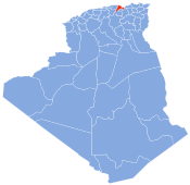
El Kseur
El Kseur | |
|---|---|
UTC+1 (West Africa Time ) |
El Kseur is a
Environment
The relief of El Kseur is characterized by its mountainous aspect. Indeed, the town is located in a narrow valley between the Ibarissen massif (the last rocky massif of Djurdjura in the east before the Gouraya massif) and the first comforts of the Babors in the South East as well as a bed Of wadi important that separates the city center to the city Berchiche one of the oldest cities of the city.
Hydrography
The hydrographic network contains a large drainage basin, namely the Soummam basin. The town of El Kseur is supplied with water by the Tichy-Haf Dam located in the locality of Bouhamza. The dam is fed by the rain and melt water of the Djurdjura's nival coat. It has a storage capacity of 150 million m3 and supplies the wilaya of Béjaïa with 20,000 m3 / day.
Climate
The town of El Kseur enjoys a temperate and humid climate with a mild winter characteristic of the Mediterranean zones and an important rainfall, like all the towns of the eastern half of the Algerian coast. Due to the mountainous massifs surrounding the city, it snow every year in winter between December and February for high altitudes of over 600 m.
Name
The indigenous people called the town of El Kseur Iɣil Mɛebed (in Berber). On the other hand, the name of El Kurs comes from the Arabic qasar, in Algerian Arabic qsar, plural qsur, meaning "palace" or "fortified village", berberized in Leqser; The municipality takes its name from a courthouse which gave its celebrity to the city. Another hypothesis, more probable, gives origin of the name the citadel (qasr) erected in 1327 during the siege of Bgayet by the Zianides. Ibn Khaldun speaks of it in his book "History of the Berbers".[1]
History

In Roman times, El Kseur was known as Tubusuctu (or even "Tubusuptu"). It was a Roman colony founded by Augustus for military veterans. Economically, the colony was known for its olive oil. Today, Roman ruins include baths, which are well preserved.
French Rule
During the colonization, El Kseur was in 1872 a center of European settlement. Many Alsatians and Lorrainers settled there, especially after the French defeat of 1870 against Prussia. Nearly 470 settlers settled in El Kseur, which took the name of Bitche. This name will not stay long since El Kseur or Ighil Maabed will take over. Today still the colonial district is present, it is on the national road, near the town hall in particular.
During the
Scouts
Born on June 14, 1928, in Ait Oussalah, a native of Ait Oussalah Arch abrares douar I3MRANEN, Salhi Hocine made his early footsteps in revolutionary militancy in Khemis-Miliana, with his classmate Si M'Hamed Bougara (another future chahid) . In 1944, on his return to his village of El-Kseur, he set himself the task of strengthening the structure of the Algerian Muslim Scouts movement, to which his contribution gave rise to considerable growth. His conduct and devotion quickly made him the driving force of this organization, which represents for him the framework of ideal expression of his patriotic convictions. He fell in the field of honor on May 5, 1958.

Demographics
In 2008, the municipality had 29,842 inhabitants. The evolution of the number of inhabitants is known through the population censuses carried out in the municipality since 1980. The city of El Kseur is the fifth largest city of the
Culture
El Kseur has always been an important cultural, intellectual and architectural center. She maintained the customs. Thus, Yennayer, the feast day of the Berber year inherited from the Berber era, is always celebrated in El Kseur. The cultural scene is animated by its cultural centers and its associations such as: the association 4e art lemri association scientific Lefnar. Association green tunnel. Troop Tafat n Usirem. The Scout Salhi Hocine Group, which has always assured major events.
References
- ^ Foudil Cheriguen, Toponymie algérienne des lieux habités (les noms composés), Alger, Épigraphe, 1993, p. 98.
- ^ http://www.lexpressiondz.com/actualite/204065-madjid-khatri-le-baroudeur.html Archived 2016-12-20 at the Wayback Machine [archive]
- ^ Le témoignage d'un rescapé nous dit que son père fut abattu à bout portant par l'armée française. Il refusait de quitter sa maison, dans le hameau de Bouhamed, et fut tué pour l'exemple.
- ^ Un mémoire de GHANEM Zoubir traite de ce sujet, Les déplacés de la guerre d'Algérie dans la vallée de la Soummam de 1955 à 1961, Paris, 2009

