
El Yunque (Puerto Rico)
| El Yunque | |
|---|---|
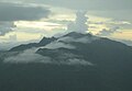
View of El Yunque from the Yokahú Tower in Río Grande, Puerto Rico | |
| Highest point | |
| Elevation | 1,080 m (3,540 ft) |
| Parent peak | El Toro |
| Coordinates | 18°18′38″N 65°47′29″W / 18.31056°N 65.79139°W |
| Naming | |
| Etymology | Yúcahu phonetic Spanish transliteration of Taíno possibly meaning 'white land' and/or El Yunque meaning 'the anvil' in Spanish due to the shape of the mountain range when seen from the south. |
| Geography | |
 El Yunque | |
Sierra de Luquillo | |
| Climbing | |
| Easiest route | Hike |
El Yunque or El Yunque Peak (
It is accessible via Mt Britton trail near the end of PR 191, which starts in PR 3 in the small town of Palmer. The best access from San Juan is via PR 66 toll express in 1 hr. which exits to PR 3. At the end of PR 191 in El Yunque there is a loop that goes to the entrance of the Mt Britton trail - close to El Yunque peak. It is one of the few places close to this trail with about 15 parking spots.
This trail is mostly paved and leads to the Mt Britton tower, the Three Peaks (Tres Picachos), the spur trail, and finally El Yunque peak with communications systems (towers) and then a small tower in the peak. The main road PR 191 has a gate at the end and after this there is a maintenance road to El Yunque and then the closed section of PR 191 which is about 3 hours long - a road that is being reclaimed by the forest and is closed due to a massive landslide. There is also the entrance the Tradewinds trail - possibly the longest trail of the park, which ends in El Toro Peak.
It's summit provides views of the other peaks of El Yunque, the vast rainforest below, and the rest of the island. The river in PR 191 called Quebrada Juan Diego is just below this peak and has a trails, waterfalls and ponds.
Background


The peak itself, standing at 1,080 metres (3,540 feet) above sea level is not the highest in Puerto Rico or even the
This peak is located on the El Yunque massif which also contains other smaller peaks such as
Climate
El Yunque is classified as having a
Gallery
-
 Morning mist in El Yunque rainforest by El Yunque peak.
 -
 El Yunque massif with Pico El Yunque, Roca El Yunque and Mount Britton.
 -
 El Yunque view from Mount Britton Tower.
 -
 El Yunque from the north.
 -
 El Yunque from Yocahu Tower.
 -
 Los Picachos (left) and El Yunque (right) covered in fog.
 -
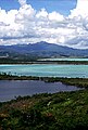 El Yunque from the Northeast Ecological Corridor.
 -


See also
References
- ^ "Taino Petroglyphs on the Rio Blanco in Puerto Rico near Naguabo". elyunque.com. Retrieved October 20, 2021.
- ^ "About the Forest MAIN". USDA Forest Service. Retrieved March 25, 2020. USDA Forest Service
- ^ "Naguabo, Puerto Rico". weatherbase.com. Retrieved January 25, 2015.
- ^ "El Yunque, Puerto Rico". welcome.topuertorico.org. Retrieved October 30, 2018.
External links
 Media related to El Yunque (Puerto Rico) at Wikimedia Commons
| International | |
|---|---|
| National | |