
Embarcadero (San Francisco)
 The Embarcadero photographed from southeast, with the Ferry Building to the right and Alcatraz Island in the distance. | |
| Maintained by | San Francisco DPW |
|---|---|
| Nearest metro station | |
| Southeast end | Second and King Streets |
| Major junctions | |
| Northwest end | Pier 45 |
Central Embarcadero Piers Historic District | |
| Location | Piers 1, 1½, 3 and 5, The Embarcadero San Francisco, California |
| Coordinates | 37°47′55″N 122°23′49″W / 37.7986°N 122.3969°W |
| Area | 6.6 acres (2.7 ha) |
| Built | 1918 |
| Architectural style | Beaux Arts |
| NRHP reference No. | 02001390[1] |
| Added to NRHP | November 20, 2002 |

The Embarcadero (
The Embarcadero
For three decades, until it was torn down in 1991, the
History
San Francisco's shoreline historically ran south and inland from
During the early-20th century when the seaport was at its busiest and before the construction of the
During World War II, San Francisco's waterfront became a military logistics center; troops, equipment and supplies left the Port in support of the Pacific theater. Almost every pier and wharf was involved in military activities, with troop ships and naval vessels tied up all along the Embarcadero.
However, after the completion of the Bay Bridge and the rapid decline of ferries and the Ferry Building, the neighborhood fell into decline. The transition to


After the
The sidewalk along the waterfront between
A large public sculpture, Cupid's Span, by Claes Oldenburg and Coosje van Bruggen, was installed in 2002 along the Rincon Park area. Resembling Cupid's bow and arrow with the arrow implanted in the ground, the artists stated that the statue was inspired by San Francisco's reputation as the home port of Eros, hence the stereotypical bow and arrow of Cupid.[5][6]
In 2016, the Embarcadero was named on the list of "11 Most Endangered Historic Places" in the US by the National Trust for Historic Preservation, citing "the dual natural threats of sea-level rise and seismic vulnerability" to the seawall.[2]
Subway station
Embarcadero Center
Embarcadero Center consists of four 30 to 45 story buildings and the Hyatt Regency San Francisco, located between the Ferry Building and the foot of Market Street. Until 2001, there was a viewing deck on top of the Embarcadero Center. During the winter holidays, the edges of all four buildings are illuminated, the effect resembling the outlines of four giant books on a shelf.
Embarcadero Plaza
At the eastern end of Market Street is Embarcadero Plaza, opened in 1972 and originally named Justin Herman Plaza, for M. Justin Herman, head of the San Francisco Redevelopment Agency from 1959 to 1971.
Education
Right along the Embarcadero Center is the Embarcadero YMCA, the city's flagship branch of a group of a dozen locales. The center features the unique Youth Chance High School, an alternative high school that is a magnet for troubled students from throughout the Bay Area.
Seawall upgrade and enhancements projects
The Embarcadero seawall is over a century old, originally constructed between 1878 and 1916, and is in need of upgrades in order to ensure its integrity in the event of a major earthquake.[7] As of February 2018[update] the Port of San Francisco, the San Francisco Municipal Transportation Agency, and several other departments are partnering to deliver a project to upgrade the seawall and adjoining public spaces. The project is expected to cost at least $2 billion, and the city successfully passed a ballot measure to issue $425 million in bonds to finance part of the project in November 2016.[8][9]
Gallery
-
 Pier 7, the Embarcadero, towards Yerba Beuna island.
 -
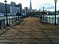 End of Pier 7, towards the Embarcadero and Transamerica Pyramid.


See also
- A Trip Down Market Street, a historic film showing the Embarcadero and Ferry Building in 1906
References
- ^ a b "National Register Information System". National Register of Historic Places. National Park Service. March 13, 2009. Retrieved October 15, 2010.
- ^ a b King, John (October 4, 2016). "Embarcadero in SF on list of nation's at-risk historic treasures". San Francisco Chronicle. Retrieved October 8, 2016.
- ^ "11 Most Endangered: San Francisco Embarcadero | National Trust for Historic Preservation". savingplaces.org. Archived from the original on July 9, 2018. Retrieved October 8, 2016.
- ^ "City and County of San Francisco – Port of San Francisco". Retrieved June 17, 2015.
- ^ Cupid's Span. Chronology of Large-Scale Projects by Claes Oldenburg and Coosje van Bruggen. oldenburgvanbruggen.com. August 25, 2009. Retrieved November 4, 2012.
- ^ Hoge, Patrick (November 23, 2002). "S.F. struck by love / Cupid's big bow gets rise out of passers-by". San Francisco Chronicle. Retrieved November 8, 2012.
- ^ King, John (July 2016). "Shoring up the city's edge". San Francisco Chronicle. Retrieved July 17, 2018.
- ^ Dineen, J.K. (February 13, 2018). "SF residents support big bond to fix seawall, poll finds". San Francisco Chronicle. Retrieved July 17, 2018.
- ^ King, John (November 6, 2018). "SF's Embarcadero seawall measure wins easily". San Francisco Chronicle. Retrieved May 6, 2019.
External links
 Media related to The Embarcadero (San Francisco) at Wikimedia Commons
| Numbered streets |  | |
|---|---|---|
| North–south streets |
| |
| East–west streets | ||
| Diagonal streets | ||
| Alleyways | ||
San Francisco place names etymologies | ||
| Downtown |  | |
|---|---|---|
| North of Downtown | ||
| Outside Lands | ||
| Western Addition | ||
| Southern | ||