
Epirus
Epirus
| |
|---|---|
 Map of ancient Epirus by Heinrich Kiepert, 1902 | |
| Present status | Divided between Greece and Albania |
| Demonym | Epirote |
| Time zones | Central European Time |
| Eastern European Time | |
Epirus (
A rugged and mountainous region, Epirus was the north-west area of
Following the
Name and etymology

The name Epirus is derived from the
Boundaries and definitions

Historically, the geographical area of Epirus proper is defined within the lines drawn from
The definition of Epirus has changed over time, such that modern administrative boundaries do not correspond to the boundaries of ancient Epirus. The region of Epirus in Greece only comprises a fraction of classical Epirus and does not include its easternmost portions, which lie in Thessaly. In Albania, where the concept of Epirus is never used in an official context, the counties of Gjirokastër, Vlorë, and Berat extend well beyond the northern and northeastern boundaries of classical Epirus.[citation needed]
Geography and ecology


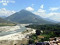
Epirus is a predominantly rugged and mountainous region. It is largely made up of the
Significant lowlands are to be found only near the coast, in the southwest near
The main river flowing through Epirus is the
The climate of Epirus is Mediterranean along the coast and Alpine in the interior. Epirus is heavily forested, mainly by coniferous species. The fauna in Epirus is especially rich and features species such as bears, wolves, foxes, deer, and lynxes.
History
Early history

In the Neolithic period Epirus was populated by seafarers along the coast and by shepherds and hunters from the southwestern Balkans who brought with them the Greek language. These people buried their leaders in large mounds containing shaft graves. Similar burial chambers were subsequently used by the Mycenaean civilization, suggesting that the founders of Mycenae may have come from Epirus and central Albania. Epirus itself remained culturally backward during this time, but Mycenaean remains have been found at two religious shrines of great antiquity in the region: the Oracle of the Dead on the Acheron River, familiar to the heroes of Homer’s Odyssey, and the Oracle of Zeus at Dodona, to whom Achilles prayed in the Iliad.[1]
In the Middle Bronze Age, Epirus was inhabited by the same nomadic Hellenic tribes that went on to settle in the rest of Greece.
Epirus in the Classical and Hellenistic periods


Geographically on the edge of the Greek world, Epirus remained for the most part outside the limelight of Greek history until relatively late, much like the neighbouring Greek regions of Macedonia, Aetolia, and Acarnania, with which Epirus had political, cultural, linguistic and economic connections..
The Epirotes, speakers of a
Beginning in 370 BC, the
On the death of Arybbas,
The Aeacid dynasty ended in 232 BC, but Epirus remained a substantial power, unified under the auspices of the Epirote League as a federal state with its own parliament, or synedrion.
Roman and Byzantine rule
Epirus as a Roman province
The region of Epirus was placed under the
Late Antiquity

Probably during the provincial reorganization by
The two Epirote provinces became part of the
The
Epirus from the Slavic invasions until 1204
In the late 6th century, much of Greece, including Epirus, fell under the control of the
Of the various Slavic tribes, only the Baiounitai, first attested c. 615, are known by name, giving their name to their region of settlement: "Vagenetia".[37] Based on the density of the Slavic toponyms in Epirus, the Slavs must have settled in the region, although the extent of this settlement is unclear.[38] Slavic toponyms occur mainly in the mountainous areas of the interior and the coasts of the Gulf of Corinth, indicative of the fact that this was the avenue used by most of the Slavs who crossed the Gulf into the Peloponnese. With the exception of some few toponyms on Corfu, the Ionian Islands seem to not have been affected by Slavic settlement. The linguistic analysis of the toponyms reveals that they date mostly to the early wave of Slavic settlement at the turn of the 6th/7th centuries. Due to scarcity of textual evidence, it is unclear how much the area was affected by the second wave of Slavic migration, which began in the middle of the 8th century due to Bulgar pressure in the northern Balkans.[39] Slavic toponyms are nearly lacking in the mountains of Labëria (on the Kurvelesh plateau), in the Ionian coast where today Lab Albanian villages neighbour with the Greek-speaking ones, therefore it can be assumed that the expansion of the Slavs had not reach this region.[40]
As in eastern Greece, the restoration of Byzantine rule seems to have proceeded from the islands, chiefly Cephallonia, which was certainly under firm Imperial control in c. 702, when

The 9th century saw great progress in the restoration of Imperial control in the mainland, as evidenced by the participation of the bishops of Ioannina,
During the early 10th century, the themes of Cephallenia and Nicopolis appear mostly as bases for expeditions against southern Italy and Sicily, while
The region joined the
Despotate of Epirus

When
The Despotate of Epirus ruled over Epirus and western Greece as far south as Naupaktos and the Gulf of Corinth, much of Albania (including Dyrrhachium), Thessaly, and the western portion of Macedonia, extending its rule briefly over central Macedonia and most of Thrace following the aggressive expansionism of Theodore Komnenos Doukas, who established the Empire of Thessalonica in 1224.[53][54] During this time, the definition of Epirus came to encompass the entire coastal region from the Ambracian Gulf to Dyrrhachium, and the hinterland to the west up to the highest peaks of the Pindus mountain range. Some of the most important cities in Epirus, such as Gjirokastër (Argyrokastron), were founded during this period.[55] The oldest reference to Albanians in Epirus is from a Venetian document dating to 1210, which states that "the continent facing the island of Corfu is inhabited by Albanians". Kosta Giakoumis believes that the use of hypothetical immigrations to explain the accounts of Albanian presence in Epirote territory prior to the 13th-14th century is somewhat arbitrary.[56]
14th century until the Ottoman conquest
In 1337, Epirus was once again brought under the rule of the

Although Albanian clans gained control of most of the region by 1366/7, their continued division into rival clans meant that they could not establish a single central authority.
The reign of
Carlo I Tocco (1411–1429) then assumed control of Ioannina, commencing heavy conflicts with Jakob and Muriq Shpata, the Albanian leaders of the Despotate of Arta. The Shpata were originally defeated by Carlo's brother Leonardo II Tocco at Mazoma near ancient Nicopolis, but Carlo's son Torno was in turn defeated by the Albanians.[67][68] After the Tocchi succeeded in capturing Rhiniasa, Leonardo tried to take Rogoi and Carlo attempted to take Arta, but Jakob and Muriq succeeded in defending their capital for the time being. Carlo withdrew to Ioannina, but soon after was able to lure Jakob to an ambush near Vobliana: Jakob was captured and immediately executed (1 October 1416).[67][68] Carlo had effectively ended the rule of the Albanian clans in southernmost Epirus.[69]
Nevertheless, internal dissension eased the Ottoman conquest, which began with the capture of Ioannina in 1430 and continued with Arta in 1449, Angelokastro in 1460, Riniasa Castle and its environs (in what is now Preveza) in 1463,[70] and finally Vonitsa in 1479. With the exception of several coastal Venetian possessions, this was also the end of Latin rule in mainland Greece.
Ottoman rule

The
Between the 16th and 19th centuries, the city of Ioannina attained great prosperity and became a major center of the
When the
20th-century Epirus

While the Treaty of Berlin (1878) awarded large parts of Epirus to Greece, opposition by the Ottomans and the League of Prizren resulted in only the region of Arta being ceded to Greece in 1881.[81] It was only following the First Balkan War of 1912–1913 and the Treaty of London that the rest of southern Epirus, including Ioannina, was incorporated into Greece.[82] Greece had also seized northern Epirus during the Balkan Wars, but the Treaty of Bucharest, which concluded the Second Balkan War, assigned Northern Epirus to Albania.[83]
This outcome was unpopular among local Greeks, as a substantial Greek population existed on the Albanian side of the border.[84] Among Greeks, northern Epirus was henceforth regarded as terra irredenta.[85] Local Greeks in northern Epirus revolted, declared their independence and proclaimed the Autonomous Republic of Northern Epirus in February 1914.[86] After fierce guerrilla fighting, they managed to gain full autonomy under the terms of the Protocol of Corfu, signed by Albanian and Northern Epirote representatives and approved by the Great Powers. The signing of the Protocol ensured that the region would have its own administration, recognized the rights of the local Greeks and provided self-government under nominal Albanian sovereignty.[87] The Republic, however, was short-lived, as when World War I broke out, Albania collapsed, and northern Epirus was alternately controlled by Greece, Italy and France at various intervals.[85][88]

Red dotted line: Territory of Autonomous State of Northern Epirus
Although the
In 1939, Italy
The whole of Epirus was then placed under Italian
With the liberation of Greece and the start of the first round of the
Economy

A rugged topography, poor soils, and fragmented landholdings have kept agricultural production low and have resulted in a low population density.[1] Animal husbandry is the main industry and corn the chief crop.[1] Oranges and olives are grown in the western lowlands, while tobacco is grown around Ioannina.[1] Epirus has few natural resources and industries, and the population has been depleted by migration.[1] The population is centered around Ioannina, which has the largest number of industrial establishments.[1]
Transportation
Epirus has historically been a remote and isolated region due to its location between the Pindus mountains and the sea. In antiquity, the Roman
Gallery
-
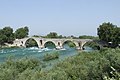 The Bridge of Arta.
 -
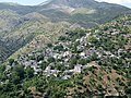
 The village of Aetomilitsa on MountPindus mountains.
 -
 The Vikos river, Vikos–Aoös National Park.
 -
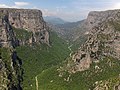 The Vikos Gorge.
 -

-
 The high altitudePindus mountains.
 -
 A canyon of the Acheron river.
 -
 The village ofSirako.
 -
 The walls of ancient Nicopolis.
 -
 The Hellenistic theater of Dodona.
 -
 Sheep under the shade of a tree near Konitsa.
 -
 The bay of Parga.
 -
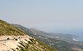 The region ofHimaraseen from the Llogara pass.
 -
 TheTepelena.
 -
 Section of the Egnatia Odos, the only motorway in Epirus, near Igoumenitsa.
 -
 UNESCO World Heritage Site.
 -
 Preveza seen from the air.


See also
- List of cities in ancient Epirus
- List of Epirotes
References
Citations
- ^ a b c d e f g h i j k l m n o p q r s t u v w x y "Epirus". Encyclopædia Britannica. Encyclopædia Britannica, Inc. Retrieved 16 November 2013.
- ^ a b c Hornblower, Spawforth & Eidinow 2012, "Epirus", p. 527.
- ^ Liddell & Scott 1940, ἤπειρ-ος.
- ^ Filos 2018, p. 215, footnote #1.
- ^ Babiniotis 1998
- ISBN 0816057222.
... in a region of northwest Greece called Epirus.
- ^ Winnifrith 2002, p. 22.
- ^ Suha 2021, p. 19
- ^ Greenwalt 2011, p. 280
- ^ Wilkes 1995, p. 92 "Appian's description of the Illyrian territories records a southern boundary with Chaonia and Thesprotia, where ancient Epirus began south of the river Aous (Vijosë)." (Map)
- ^ Bahr, Johnston & Bloomfield 1997, p. 389.
- ^ Borza 1992, pp. 62, 78, 98; Minahan 2002, p. 578.
- ^ Hammond 1986, p. 77: "The original home of the Hellenes was 'Hellas', the area round Dodona in Epirus, according to Aristotle. In the Iliad it was the home of Achilles' Hellenes."
- ^ Aristotle. Meteorologica, 1.14 Archived 29 June 2011 at the Wayback Machine: "Rather we must take the cause of all these changes to be that, just as winter occurs in the seasons of the year, so in determined periods there comes a great winter of a great year and with it excess of rain. But this excess does not always occur in the same place. The deluge in the time of Deucalion, for instance, took place chiefly in the Greek world and in it especially about ancient Hellas, the country about Dodona and the Achelous, a river which has often changed its course. Here the Selli dwelt and those who were formerly called Graeci and now Hellenes."
- ^ Georgiev 1981, p. 192: "Late Neolithic Period: in northwestern Greece the Proto-Greek language had already been formed: this is the original home of the Greeks."
- ^ Hammond 1998; Wilkes 1995, p. 104; Hammond 1994, pp. 430, 434; Hammond 1982, p. 284.
- ^ Hammond 1967.
- ^ Thucydides. The History of the Peloponnesian War, 1.8 Archived 5 August 2011 at the Wayback Machine.
- ^ Strabo. Geography, 7.7.1.
- ^ Strabo. Geography, 7.11
- ^ Herodotus. Histories, 6.127.
- ^ Dionysius of Halicarnassus. Roman Antiquities, 20.10 (19.11).
- ^ Pausanias. Description of Greece, 1.11.7–1.12.2.
- ^ Eutropius. Abridgment of Roman History (Historiae Romanae Breviarium), 2.11.13.
- ^ Davies 2002, pp. 234–258.
- ^ Cameron 2004, p. 141: "As for Aspestos, Achilles was honored in Epirus under that name, and the patronymic [Ἀ]σπετίδης is found in a fragmentary poem found on papyrus."
- Kytherosc. 340 BC.
- ^ Anson 2010, p. 5.
- ^ Livy (1926), 8.24.8–14
- ^ a b c Soustal & Koder 1981, p. 47.
- ^ Soustal & Koder 1981, pp. 47–48.
- ^ a b c d e Soustal & Koder 1981, p. 48.
- ^ Soustal & Koder 1981, pp. 48–49.
- ^ a b c d Soustal & Koder 1981, p. 49.
- ^ a b Soustal & Koder 1981, p. 50.
- ^ a b Soustal & Koder 1981, p. 51.
- ^ Osswald 2007, p. 128.
- ^ Soustal & Koder 1981, pp. 51–52.
- ^ Desnickaja 1973, p. 48.
- ^ a b Soustal & Koder 1981, p. 52.
- ^ a b c Soustal & Koder 1981, p. 53.
- ^ a b Fine 1991, p. 64.
- ^ Kazhdan 1991, p. 1485.
- ^ Soustal & Koder 1981, pp. 53–54.
- ^ Kazhdan 1991, p. 668.
- ^ a b Soustal & Koder 1981, p. 54.
- ^ a b c Soustal & Koder 1981, p. 55.
- ^ Soustal & Koder 1981, pp. 55–56.
- ^ Osswald 2007, p. 129.
- ^ Soustal & Koder 1981, pp. 59–61.
- ^ a b Osswald 2007, p. 132.
- ^ Nicol 1984, "Introduction", pp. 4–5.
- ^ a b Osswald 2007, p. 133.
- ^ Giakoumis 2002, p. 176.
- ^ Giakoumis 2002, p. 176: "Are we obliged to see in this a possible earlier Albanian immigration in the Epeirote lands, as Kostas Komis did in the case of the etymology of the toponym 'Preveza'? I believe that the use of hypothetical immigrations as a basis to interpret sources that indicate the presence of Albanians in the Epeirote lands prior to the thirteenth-fourteenth century is somewhat arbitrary."
- ^ Osswald 2007, p. 135.
- ^ Epeirotica 2.220; cf. 222 f
- ^ Fine 1994, pp. 348–351.
- ^ Sansaridou-Hendrickx 2017, p. 294.
- ^ Nicol 1984, pp. 142–145.
- ISBN 978-960-213-371-2.
For the Albanian tribes of the Mazarakaioi and the Malakasioi, led by Peter Losha the despot of Arta,
- ^ Nicol 1984, pp. 142–145; Fine 1994, pp. 351–352; Sansaridou-Hendrickx 2017, p. 294.
- ^ Hammond, 1976 & ps"The Albanians and in particular the Mazarakii of the Kalamas valley held firm against him. In 1385 he was assassinated by some of his own bodyguards" (Epeirotica 2.230), p. 59.
- ^ Hutchinson, Richard Wyatt (1956). The Lord of Patras (PDF). A.G. Kalokairinos. p. 343.
- ^ Osswald 2007, p. 134.
- ^ a b PLP, 26521. Σπάτας Γιαγούπης.
- ^ a b Nicol 1984, p. 186.
- ^ Osswald 2007, p. 136.
- ^ Karabelas 2015, pp. 972–975.
- ^ Sakellariou 1997, p. 268.
- ^ Fleming 1999, pp. 63–66.
- ^ The Era of Enlightenment (Late 7th century–1821). Εθνικό Kέντρο Bιβλίου, p. 13.
- ^ Υπουργείο Εσωτερικών, Αποκέντρωσης και Ηλεκρονικής Διακυβέρνησης Περιφέρεια Ηπείρου: "Στη δεκαετία του 1790 ο νεοελληνικός διαφωτισμός έφθασε στο κορύφωμά του. Φορέας του πνεύματος στα Ιωάννινα είναι ο Αθανάσιος Ψαλίδας."
- ^ Fleming 1999, p. 64.
- ^ Reid 2000.
- ^ Jelavich & Jelavich 1977, p. 226.
- ^ Ramet 1998, p. 205.
- ^ Blumi 2002, p. 57.
- ^ Hammond 1976, p. 41: "Throughout this period bands of Albanians raiders pillaged and destroyed the villages of the Vlachs and the Greeks in Epirus, northern Pindus, the lakeland of Prespa and Ochrid, and parts of western Macedonia. One Albanian leader, 'Ali the Lion', emulated the achievements of 'John the Sword' and 'Peter the Pockmark' when he established himself as Ali Pasha, independent ruler of Ioannina. He and his Albanian soldiers, recruited mainly from his homeland in the Kurvelesh and the Drin valley of North Epirus, controlled the whole of Epirus and carried their raids far into western Macedonia and Thessaly. As we have seen, they destroyed the Vlach settlements in the lakeland and weakened those farther south. After the assassination of Ali Pasha in 1822 sporadic raids by bands of Albanians were a feature of life in northern Greece until the liberation of 1912–13".
- ^ Gawrych 2006, pp. 68–69.
- ^ Clogg 2002, p. 105: "In February 1913 the Greek Army seized Ioannina, the capital of Epirus. The Turks recognized the gains of the Balkan allies by the Treaty of London, in May 1913."
- ^ Clogg 2002, p. 105 "The Second Balkan War had short duration and the Bulgarians were soon dragged to the table of negotiations. By the Treaty of Bucharest (August 1913) Bulgaria was forced to accept a little favourable regulation of the borders, even if she kept a way to the Aegean, in Degeagatch (modern Alexandroupolis). The sovereignty of Greece over Crete was now recognised, but her ambition to annex Northern Epirus with its large Greek population was stopped by the annexation of the area to an independent Albania".
- ^ Pettifer 2001, p. 4.
- ^ a b c d e f Konidaris 2013, pp. 64–92.
- ^ Winnifrith 2002, p. 130.
- ^ Triadafilopoulos 2000, p. 152.
- ^ Tucker & Roberts 2005, p. 77.
- ^ Soteriades 1918: Map
- ^ Miller 1966, pp. 543–544.
- ^ a b Konidaris 2013, p. 67.
- ^ Pettifer 2001, p. 7.
General and cited sources
- Anson, Edward M. (2010). "Why Study Ancient Macedonia and What This Companion is About". In Roisman, Joseph; Worthington, Ian (eds.). A Companion to Ancient Macedonia. Oxford, Chichester, & Malden: Wiley-Blackwell. pp. 3–20. ISBN 978-1-4051-7936-2.
- Antoniadis, Vyron (2016). Tabula Imperii Romani : J 34 - Athens : Epirus. Athens: Academy of Athens. ISBN 978-960-404-308-8.
- Babiniotis, Georgios (1998). Lexiko tis Neas Ellinikis Glossas. Athens, Greece: Kentro Lexikologias. ISBN 960-86190-0-9.
- Bahr, Lauren S.; Johnston, Bernard; Bloomfield, Louise A. (1997). Collier's Encyclopedia. Vol. 11. New York, NY: Collier.
- Blumi, Isa (2002). "The Role of Education in the Albanian Identity and its Myths". In Schwandner-Sievers, Stephanie; Fischer, Bernd Jürgen (eds.). Albanian Identities: Myth and History. Bloomington, IN: Indiana University Press. pp. 49–59. ISBN 0-253-21570-6.
- Borza, Eugene N. (1992). In the Shadow of Olympus: The Emergence of Macedon (Revised ed.). Princeton, NJ: Princeton University Press. ISBN 0-691-00880-9.
- Bowden, William (2003). Epirus Vetus: The Archaeology of a Late Antique Province. London: Gerald Duckworth & Co. Limited. ISBN 0-7156-3116-0.
- Cameron, Alan (2004). Greek Mythography in the Roman World. New York and Oxford: Oxford University Press. ISBN 0-19-517121-7.
- Clogg, Richard (2002) [1992]. A Concise History of Greece (2nd ed.). Cambridge and New York: Cambridge University Press. ISBN 978-0-52-100479-4.
- Davies, J. K. (2002). "13. A Wholly Non-Aristotelian Universe: The Molossians as Ethnos, State, and Monarchy". In Brock, Roger; Hodkinson, Stephen (eds.). Alternatives to Athens: Varieties of Political Organization and Community in Ancient Greece. Oxford: Oxford University Press. pp. 234–258. ISBN 0-19-925810-4.
- Desnickaja, A. V. (1973). "Language Interferences and Historical Dialectology". Linguistics. 11 (113): 41–52. S2CID 144569294.
- Fleming, Katherine Elizabeth (1999). The Muslim Bonaparte: Diplomacy and Orientalism in Ali Pasha's Greece. Princeton, NJ: Princeton University Press. ISBN 0-691-00194-4.
- Filos, Panagiotis (2018). "The Dialectal Variety of Epirus". In Giannakis, Georgios; Crespo, Emilio; Filos, Panagiotis (eds.). Studies in Ancient Greek Dialects: From Central Greece to the Black Sea. Berlin and Boston: Walter de Gruyter. pp. 215–248. ISBN 9783110532135.
- ISBN 0-472-08149-7.
- ISBN 0-472-08260-4.
- Gawrych, George Walter (2006). The Crescent and the Eagle: Ottoman Rule, Islam and the Albanians, 1874–1913. New York and London: I.B. Tauris. ISBN 1-84511-287-3.
- Georgiev, Vladimir Ivanov (1981). Introduction to the History of the Indo-European Languages. Sofia: Bulgarian Academy of Sciences. ISBN 9789535172611.
- Giakoumis, Kosta (2002). "Fourteenth-century Albanian migration and the 'relative autochthony' of the Albanians in Epeiros. The case of Gjirokastër". Byzantine and Modern Greek Studies. 27: 171–183. .
- Greenwalt, William S. (2011). "Macedonia, Illyria and Epirus". In Roisman, Joseph; Worthington, Ian (eds.). A Companion to Ancient Macedonia. John Wiley & Sons. pp. 279–305. ISBN 978-1-4443-5163-7.
- Hammond, Nicholas Geoffrey Lemprière (1967). Epirus: The Geography, the Ancient Remains, the History and the Topography of Epirus and Adjacent Areas. Oxford: The Clarendon Press.
- Hammond, Nicholas Geoffrey Lemprière (1976). Migrations and Invasions in Greece and Adjacent Areas. Park Ridge, NJ: Noyes Press. ISBN 0-8155-5047-2.
- Hammond, Nicholas Geoffrey Lemprière (1982). "ILLYRIS, EPIRUS AND MACEDONIA". In ISBN 9780521234474.
- Hammond, Nicholas Geoffrey Lemprière (1986). A History of Greece to 322 B.C. Oxford: Clarendon Press. ISBN 0-19-873096-9.
- Hammond, Nicholas Geoffrey Lemprière (1994). "ILLYRIANS AND NORTH-WEST GREEKS". In ISBN 9780521233484.
- Hammond, Nicholas Geoffrey Lemprière (1998). Philip of Macedon. London: Duckworth. ISBN 0-7156-2829-1.
- Hornblower, Simon; Spawforth, Antony; Eidinow, Esther (2012) [1949]. The Oxford Classical Dictionary (4th ed.). Oxford: Oxford University Press. ISBN 978-0-19-954556-8.
- Jelavich, Charles; Jelavich, Barbara (1977). The Establishment of the Balkan National States, 1804–1920: A History of East Central Europe. Vol. VIII. Seattle, WA: University of Washington Press. ISBN 0-295-96413-8.
- Karabelas, Nikos D. (2015). The Ottoman Conquest of Preveza and its First Castle. XVIth Turkish Congress of History, organised by the Turkish Historical Society, in Ankara, 20–24 September 2010. Kongreye Sunulan Bildiriler, Volume 4, Part 2, Osmanli Tarihi. Ankara: Türk Tarih Kurumu. pp. 967–998. ISBN 978-975-16-2982-1.
- ISBN 0-19-504652-8.
- Konidaris, Gerasimos (2013). "Examining Policy Responses to Immigration in the Light of Interstate Relations and Foreign Policy Objectives: Greece and Albania". In King, Russell; Mai, Nicola; Schwandner-Sievers, Stephanie (eds.). The New Albanian Migration. Portland, OR: Sussex Academic Press. pp. 64–92. ISBN 9781837641932.
- Liddell, Henry George; Scott, Robert (1940). A Greek-English Lexicon. Oxford: Clarendon Press.
- McHenry, Robert (2003). The New Encyclopædia Britannica (15th ed.). Chicago, IL: Encyclopædia Britannica, Inc. ISBN 978-0-85229-961-6.
- Miller, William (1966). The Ottoman Empire and Its Successors, 1801–1927. New York and London: Frank Cass. ISBN 978-0-7146-1974-3.
- Minahan, James (2002). Encyclopedia of the Stateless Nations: Ethnic and National Groups around the World. Westport, CT: Greenwood Press. ISBN 978-0313076961.
- Nicol, Donald MacGillivray (1984). The Despotate of Epiros, 1267–1479: A Contribution to the History of Greece. Cambridge: Cambridge University Press. ISBN 978-0-521-26190-6.
- Osswald, Brendan (2007). "The Ethnic Composition of Medieval Epirus". In Ellis, Steven G.; Klusáková, Lud'a (eds.). Imagining Frontiers, Contesting Identities. Pisa: Edizioni Plus – Pisa University Press. pp. 125–154. ISBN 978-88-8492-466-7.
- Pettifer, James (2001). The Greek Minority in Albania – In the Aftermath of Communism. Camberley, Surrey: Conflict Studies Research Centre, Royal Military Academy Sandhurst. ISBN 1-903584-35-3. Archived from the original(PDF) on 21 May 2010.
- Trapp, Erich; Beyer, Hans-Veit; Walther, Rainer; Sturm-Schnabl, Katja; Kislinger, Ewald; Leontiadis, Ioannis; Kaplaneres, Sokrates (1976–1996). ISBN 3-7001-3003-1.
- Ramet, Sabrina P. (1998). Nihil Obstat: Religion, Politics, and Social Change in East-Central Europe and Russia. Durham, NC: Duke University Press. ISBN 0-8223-2070-3.
- Reid, James J. (2000). Crisis of the Ottoman Empire: Prelude to Collapse 1839–1878. Stuttgart: Franz Steiner Verlag. ISBN 3-515-07687-5.
- Ruches, Pyrrhus J. (1965). Albania's Captives. Chicago, IL: Argonaut Incorporated, Publishers.
- Sakellariou, M. V. (1997). Epirus, 4000 Years of Greek History and Civilization. Athens, Greece: Ekdotikē Athēnōn. ISBN 960-213-371-6.
- Sansaridou-Hendrickx, Thekla (2017). "The Albanians in the Chronicle(s) of Ioannina: An Anthropological Approach". Acta Patristica et Byzantina. 21 (2): 287–306. S2CID 163742869.
- Soteriades, Georgios (1918). An Ethnological Map Illustrating Hellenism in the Balkan Peninsula and Asia Minor. London: Edward Stanford.
- Soustal, Peter; Koder, Johannes (1981). Tabula Imperii Byzantini, Band 3: Nikopolis und Kephallēnia (in German). Vienna: ISBN 978-3-7001-0399-8.
- Suha, Mikko (2021). Late Classical – Hellenistic Fortifications in Epirus: Fourth to Second Century BC (Thesis). Unigrafia, University of Helsinki. ISBN 978-951-51-7673-8.
- Tandy, David W. (2001). Prehistory and History: Ethnicity, Class and Political Economy. Montréal, Québec, Canada: Black Rose Books Limited. ISBN 1-55164-188-7.
- Triadafilopoulos, Triadafilos (November 2000). "Power politics and nationalist discourse in the struggle for 'Northern Epirus': 1919-1921". Journal of Southern Europe and the Balkans. 2 (2): 149–162. S2CID 140687333. Retrieved 17 June 2023.
- Tucker, Spencer; Roberts, Priscilla Mary (2005). World War I: Encyclopedia. Santa Barbara, CA: ABC-CLIO Incorporated. ISBN 1-85109-420-2.
- Wilkes, John J. (1995). The Illyrians. Oxford: Blackwell Publishers Limited. ISBN 0-631-19807-5.
- Winnifrith, Tom (2002). Badlands, Borderlands: A History of Northern Epirus/Southern Albania. London: Duckworth. ISBN 0-7156-3201-9.
External links
- Didrachm of the Epirote League
- Epirus Info Guide
- Panepirotic Federation of America Archived 11 June 2008 at the Wayback Machine
- Panepirotic Federation of Greece
- Panepirotic Society of Cairo
- Folk music in Epirus by musicologist Christopher C. King
| International | |
|---|---|
| National | |
| Geographic | |