
Geologic time scale
The geologic time scale or geological time scale (GTS) is a representation of time based on the rock record of Earth. It is a system of chronological dating that uses chronostratigraphy (the process of relating strata to time) and geochronology (a scientific branch of geology that aims to determine the age of rocks). It is used primarily by Earth scientists (including geologists, paleontologists, geophysicists, geochemists, and paleoclimatologists) to describe the timing and relationships of events in geologic history. The time scale has been developed through the study of rock layers and the observation of their relationships and identifying features such as lithologies, paleomagnetic properties, and fossils. The definition of standardised international units of geologic time is the responsibility of the International Commission on Stratigraphy (ICS), a constituent body of the International Union of Geological Sciences (IUGS), whose primary objective[1] is to precisely define global chronostratigraphic units of the International Chronostratigraphic Chart (ICC)[2] that are used to define divisions of geologic time. The chronostratigraphic divisions are in turn used to define geochronologic units.[2]
While some regional terms are still in use,[3] the table of geologic time presented in this article conforms to the nomenclature, ages, and colour codes set forth by the ICS.[1][4]
Principles
The geologic time scale is a way of representing deep time based on events that have occurred throughout Earth's history, a time span of about 4.54 ± 0.05 Ga (4.54 billion years).[5] It chronologically organises strata, and subsequently time, by observing fundamental changes in stratigraphy that correspond to major geological or paleontological events. For example, the Cretaceous–Paleogene extinction event, marks the lower boundary of the Paleogene System/Period and thus the boundary between the Cretaceous and Paleogene systems/periods. For divisions prior to the Cryogenian, arbitrary numeric boundary definitions (Global Standard Stratigraphic Ages, GSSAs) are used to divide geologic time. Proposals have been made to better reconcile these divisions with the rock record.[6][3]
Historically, regional geologic time scales were used[3] due to the litho- and biostratigraphic differences around the world in time equivalent rocks. The ICS has long worked to reconcile conflicting terminology by standardising globally significant and identifiable stratigraphic horizons that can be used to define the lower boundaries of chronostratigraphic units. Defining chronostratigraphic units in such a manner allows for the use of global, standardised nomenclature. The ICC represents this ongoing effort.
The relative relationships of rocks for determining their chronostratigraphic positions use the overriding principles of:[7][8][9][10]
- Superposition – Newer rock beds will lie on top of older rock beds unless the succession has been overturned.
- Horizontality – All rock layers were originally deposited horizontally.[note 1]
- Lateral continuity – Originally deposited layers of rock extend laterally in all directions until either thinning out or being cut off by a different rock layer.
- Biologic succession (where applicable) – This states that each stratum in a succession contains a distinctive set of fossils. This allows for a correlation of the stratum even when the horizon between them is not continuous.
- Cross-cutting relationships – A rock feature that cuts across another feature must be younger than the rock it cuts across.
- Inclusion – Small fragments of one type of rock but embedded in a second type of rock must have formed first, and were included when the second rock was forming.
- Relationships of unconformities – Geologic features representing periods of erosion or non-deposition, indicating non-continuous sediment deposition.
Terminology
The GTS is divided into chronostratigraphic units and their corresponding geochronologic units. These are represented on the ICC published by the ICS; however, regional terms are still in use in some areas.
Chronostratigraphy is the element of stratigraphy that deals with the relation between rock bodies and the relative measurement of geological time.[11] It is the process where distinct strata between defined stratigraphic horizons are assigned to represent a relative interval of geologic time.
A chronostratigraphic unit is a body of rock, layered or unlayered, that is defined between specified stratigraphic horizons which represent specified intervals of geologic time. They include all rocks representative of a specific interval of geologic time, and only this time span.[11] Eonothem, erathem, system, series, subseries, stage, and substage are the hierarchical chronostratigraphic units.[11] Geochronology is the scientific branch of geology that aims to determine the age of rocks, fossils, and sediments either through absolute (e.g., radiometric dating) or relative means (e.g., stratigraphic position, paleomagnetism, stable isotope ratios).[12]
A geochronologic unit is a subdivision of geologic time. It is a numeric representation of an intangible property (time).[12] Eon, era, period, epoch, subepoch, age, and subage are the hierarchical geochronologic units.[11] Geochronometry is the field of geochronology that numerically quantifies geologic time.[12]
A Global Boundary Stratotype Section and Point (GSSP) is an internationally agreed upon reference point on a stratigraphic section which defines the lower boundaries of stages on the geologic time scale.[13] (Recently this has been used to define the base of a system)[14]
A Global Standard Stratigraphic Age (GSSA)[15] is a numeric only, chronologic reference point used to define the base of geochronologic units prior to the Cryogenian. These points are arbitrarily defined.[11] They are used where GSSPs have not yet been established. Research is ongoing to define GSSPs for the base of all units that are currently defined by GSSAs.
The numeric (geochronometric) representation of a geochronologic unit can, and is more often subject to change when geochronology refines the geochronometry, while the equivalent chronostratigraphic unit remains the same, and their revision is less common. For example, in early 2022 the boundary between the
The numeric values on the ICC are represented by the unit
Divisions of geologic time
- An eon is the largest geochronologic time unit and is equivalent to a chronostratigraphic eonothem.[16] There are four formally defined eons: the Hadean, Archean, Proterozoic and Phanerozoic.[2]
- An era is the second largest geochronologic time unit and is equivalent to a chronostratigraphic erathem.[11][16] There are ten defined eras: the Eoarchean, Paleoarchean, Mesoarchean, Neoarchean, Paleoproterozoic, Mesoproterozoic, Neoproterozoic, Paleozoic, Mesozoic and Cenozoic, with none from the Hadean eon.[2]
- A period is equivalent to a chronostratigraphic system.[11][16] There are 22 defined periods, with the current being the Quaternary period.[2] As an exception two subperiods are used for the Carboniferous Period.[11]
- An epoch is the second smallest geochronologic unit. It is equivalent to a chronostratigraphic series.[11][16] There are 37 defined epochs and one informal one. There are also 11 subepochs which are all within the Neogene and Quaternary.[2] The use of subepochs as formal units in international chronostratigraphy was ratified in 2022.[17]
- An age is the smallest hierarchical geochronologic unit and is equivalent to a chronostratigraphic stage.[11][16] There are 96 formal and five informal ages.[2]
- A chron is a non-hierarchical formal geochronology unit of unspecified rank and is equivalent to a chronostratigraphic chronozone.[11] These correlate with magnetostratigraphic, lithostratigraphic, or biostratigraphic units as they are based on previously defined stratigraphic units or geologic features.
The Early and Late subdivisions are used as the geochronologic equivalents of the chronostratigraphic Lower and Upper, e.g., Early Triassic Period (geochronologic unit) is used in place of Lower Triassic Series (chronostratigraphic unit).
Rocks representing a given chronostratigraphic unit are that chronostratigraphic unit, and the time they were laid down in is the geochronologic unit, i.e., the rocks that represent the Silurian Series are the Silurian Series and they were deposited during the Silurian Period.
| Chronostratigraphic unit (strata) | Geochronologic unit (time) | Time span[note 2] |
|---|---|---|
| Eonothem | Eon | Several hundred million years to two billion years |
| Erathem | Era | Tens to hundreds of millions of years |
| System | Period | Millions of years to tens of millions of years |
| Series | Epoch | Hundreds of thousands of years to tens of millions of years |
| Subseries | Subepoch | Thousands of years to millions of years |
| Stage | Age | Thousands of years to millions of years |
Naming of geologic time
The names of geologic time units are defined for chronostratigraphic units with the corresponding geochronologic unit sharing the same name with a change to the latter (e.g. Phanerozoic Eonothem becomes the Phanerozoic Eon). Names of erathems in the Phanerozoic were chosen to reflect major changes in the history of life on Earth: Paleozoic (old life), Mesozoic (middle life), and Cenozoic (new life). Names of systems are diverse in origin, with some indicating chronologic position (e.g., Paleogene), while others are named for lithology (e.g., Cretaceous), geography (e.g., Permian), or are tribal (e.g., Ordovician) in origin. Most currently recognised series and subseries are named for their position within a system/series (early/middle/late); however, the ICS advocates for all new series and subseries to be named for a geographic feature in the vicinity of its stratotype or type locality. The name of stages should also be derived from a geographic feature in the locality of its stratotype or type locality.[11]
Informally, the time before the Cambrian is often referred to as the Precambrian or pre-Cambrian (Supereon).[6][note 3]
| Name | Time span | Duration (million years) | Etymology of name |
|---|---|---|---|
| Phanerozoic | 538.8 to 0 million years ago | 538.8 | From the Greek words φανερός (phanerós) meaning 'visible' or 'abundant', and ζωή (zoē) meaning 'life'. |
| Proterozoic | 2,500 to 538.8 million years ago | 1961.2 | From the Greek words πρότερος (próteros) meaning 'former' or 'earlier', and ζωή (zoē) meaning 'life'. |
| Archean | 4,031 to 2,500 million years ago | 1531 | From the Greek word αρχή (archē), meaning 'beginning, origin'.
|
| Hadean | 4,567.3 to 4,031 million years ago | 536.3 | From Hades, Greek: ᾍδης, translit. Háidēs, the god of the underworld (hell, the inferno) in Greek mythology. |
| Name | Time span | Duration (million years) | Etymology of name |
|---|---|---|---|
| Cenozoic | 66 to 0 million years ago | 66 | From the Greek words καινός (kainós) meaning 'new', and ζωή (zōḗ) meaning 'life'. |
| Mesozoic | 251.9 to 66 million years ago | 185.902 | From the Greek words μέσο (méso) meaning 'middle', and ζωή (zōḗ) meaning 'life'. |
| Paleozoic | 538.8 to 251.9 million years ago | 286.898 | From the Greek words παλιός (palaiós) meaning 'old', and ζωή (zōḗ) meaning 'life'. |
| Neoproterozoic | 1,000 to 538.8 million years ago | 461.2 | From the Greek words νέος (néos) meaning 'new' or 'young', πρότερος (próteros) meaning 'former' or 'earlier', and ζωή (zōḗ) meaning 'life'. |
| Mesoproterozoic | 1,600 to 1,000 million years ago | 600 | From the Greek words μέσο (méso) meaning 'middle', πρότερος (próteros) meaning 'former' or 'earlier', and ζωή (zōḗ) meaning 'life'. |
| Paleoproterozoic | 2,500 to 1,600 million years ago | 900 | From the Greek words παλιός (palaiós) meaning 'old', πρότερος (próteros) meaning 'former' or 'earlier', and ζωή (zōḗ) meaning 'life'. |
| Neoarchean | 2,800 to 2,500 million years ago | 300 | From the Greek words νέος (néos) meaning 'new' or 'young', and ἀρχαῖος (arkhaîos) meaning 'ancient'. |
| Mesoarchean | 3,200 to 2,800 million years ago | 400 | From the Greek words μέσο (méso) meaning 'middle', and ἀρχαῖος (arkhaîos) meaning 'ancient'. |
| Paleoarchean | 3,600 to 3,200 million years ago | 400 | From the Greek words παλιός (palaiós) meaning 'old', and ἀρχαῖος (arkhaîos) meaning 'ancient'. |
| Eoarchean | 4,031 to 3,600 million years ago | 431 | From the Greek words Ηώς (Ēṓs) meaning 'dawn', and ἀρχαῖος (arkhaîos) meaning 'ancient'. |
| Name | Time span | Duration (million years) | Etymology of name |
|---|---|---|---|
| Quaternary[note 4] | 2.6 to 0 million years ago | 2.58 | First introduced by Jules Desnoyers in 1829 for sediments in France's Seine Basin that appeared to be younger than Tertiary[note 5] rocks.[18] |
| Neogene | 23 to 2.6 million years ago | 20.45 | Derived from the Greek words νέος (néos) meaning 'new', and γενεά (geneá) meaning 'genesis' or 'birth'. |
| Paleogene | 66 to 23 million years ago | 42.97 | Derived from the Greek words παλιός (palaiós) meaning 'old', and γενεά (geneá) meaning 'genesis' or 'birth'. |
| Cretaceous | ~145 to 66 million years ago | ~79 | Derived from Terrain Crétacé used in 1822 by Jean d'Omalius d'Halloy in reference to extensive beds of chalk within the Paris Basin.[19] Ultimately derived from the Latin crēta meaning chalk.
|
| Jurassic | 201.4 to 145 million years ago | ~56.4 | Named after the Jura Mountains. Originally used by Alexander von Humboldt as 'Jura Kalkstein' (Jura limestone) in 1799.[20] Alexandre Brongniart was the first to publish the term Jurassic in 1829.[21][22] |
| Triassic | 251.9 to 201.4 million years ago | 50.502 | From the Trias of Friedrich August von Alberti in reference to a trio of formations widespread in southern Germany |
| Permian | 298.9 to 251.9 million years ago | 46.998 | Named after the historical region of Perm, Russian Empire.[23] |
| Carboniferous | 358.9 to 298.9 million years ago | 60 | Means 'coal-bearing', from the Latin carbō (coal) and ferō (to bear, carry).[24] |
| Devonian | 419.2 to 358.9 million years ago | 60.3 | Named after Devon, England.[25] |
| Silurian | 443.8 to 419.2 million years ago | 24.6 | Named after the Celtic tribe, the Silures.[26] |
| Ordovician | 485.4 to 443.8 million years ago | 41.6 | Named after the Celtic tribe, Ordovices.[27][28] |
| Cambrian | 538.8 to 485.4 million years ago | 53.4 | Named for Cambria, a latinised form of the Welsh name for Wales, Cymru.[29] |
| Ediacaran | 635 to 538.8 million years ago | ~96.2 | Named for the Ediacara Hills. Ediacara is possibly a corruption of the Kuyani words 'Yata Takarra' meaning hard or stony ground.[30][31] |
| Cryogenian | 720 to 635 million years ago | ~85 | From the Greek words κρύος (krýos) meaning 'cold', and, γένεσις (génesis) meaning 'birth'.[3] |
| Tonian | 1,000 to 720 million years ago | ~280 | From the Greek word τόνος (tónos) meaning 'stretch'.[3] |
| Stenian | 1,200 to 1,000 million years ago | 200 | From the Greek word στενός (stenós) meaning 'narrow'.[3] |
| Ectasian | 1,400 to 1,200 million years ago | 200 | From the Greek word ἔκτᾰσῐς (éktasis) meaning 'extension'.[3] |
| Calymmian | 1,600 to 1,400 million years ago | 200 | From the Greek word κάλυμμᾰ (kálumma) meaning 'cover'.[3] |
| Statherian | 1,800 to 1,600 million years ago | 200 | From the Greek word σταθερός (statherós) meaning 'stable'.[3] |
| Orosirian | 2,050 to 1,800 million years ago | 250 | From the Greek word ὀροσειρά (oroseirá) meaning 'mountain range'.[3] |
| Rhyacian | 2,300 to 2,050 million years ago | 250 | From the Greek word ῥύαξ (rhýax) meaning 'stream of lava'.[3] |
| Siderian | 2,500 to 2,300 million years ago | 200 | From the Greek word σίδηρος (sídēros) meaning 'iron'.[3] |
| Name | Time span | Duration (million years) | Etymology of name |
|---|---|---|---|
| Holocene | 0.012 to 0 million years ago | 0.0117 | From the Greek words ὅλος (hólos) meaning 'whole', and καινός (kainós) meaning 'new' via French |
| Pleistocene | 2.58 to 0.012 million years ago | 2.5683 | Coined in the early 1830s from the Greek words πλεῖστος (pleîstos) meaning 'most', and καινός (kainós) meaning 'new' |
| Pliocene | 5.33 to 2.58 million years ago | 2.753 | Coined in the early 1830s from the Greek words πλείων (pleíōn) meaning 'more', and καινός (kainós) meaning 'new' |
| Miocene | 23.03 to 5.33 million years ago | 17.697 | Coined in the early 1830s from the Greek words μείων (meíōn) meaning 'less', and καινός (kainós) meaning 'new' |
| Oligocene | 33.9 to 23.03 million years ago | 10.87 | Coined in the 1850s from the Greek words ὀλίγος (olígos) meaning 'few', and καινός (kainós) meaning 'new' via German |
| Eocene | 56 to 33.9 million years ago | 22.1 | Coined in the early 1830s from the Greek words ἠώς (ēōs) meaning 'dawn', and καινός (kainós) meaning 'new', referring to the dawn of modern life during this epoch |
| Paleocene | 66 to 56 million years ago | 10 | Coined by Wilhelm Philippe Schimper in 1874 as a portmanteau of paleo- + Eocene, but on the surface from the Greek words παλαιός (palaios) meaning 'old', and καινός (kainós) meaning 'new' via French |
Upper Cretaceous
|
100.5 to 66 million years ago | 34.5 | See Cretaceous |
Lower Cretaceous
|
145 to 100.5 million years ago | 44.5 | |
Upper Jurassic |
161.5 to 145 million years ago | 16.5 | See Jurassic |
| Middle Jurassic | 174.7 to 161.5 million years ago | 13.2 | |
Lower Jurassic |
201.4 to 174.7 million years ago | 26.7 | |
Upper Triassic
|
237 to 201.4 million years ago | 35.6 | See Triassic |
| Middle Triassic |
247.2 to 237 million years ago | 10.2 | |
Lower Triassic
|
251.9 to 247.2 million years ago | 4.702 | |
| Lopingian | 259.51 to 251.9 million years ago | 7.608 | Named for Loping, China, an anglicization of the Mandarin word 乐平 (lèpíng) meaning 'peaceful music' |
| Guadalupian | 273.01 to 259.51 million years ago | 13.5 | Named for the Guadalupe Mountains of the American Southwest, ultimately from Arabic وَادِي ٱل (wādī al) meaning 'valley of the', and Latin lupus meaning 'wolf' via Spanish |
| Cisuralian | 298.9 to 273.01 million years ago | 25.89 | From Latin cis- (before) + Russian Урал (Ural), referring to the western slopes of the Ural Mountains |
| Upper Pennsylvanian | 307 to 298.9 million years ago | 8.1 | Named for the US state of Pennsylvania, from William Penn + Latin silvanus (forest) + -ia by analogy to Transylvania |
| Middle Pennsylvanian | 315.2 to 307 million years ago | 8.2 | |
| Lower Pennsylvanian | 323.2 to 315.2 million years ago | 8 | |
| Upper Mississippian | 330.9 to 323.2 million years ago | 7.7 | Named for the Mississippi River, from the Ojibwe word ᒥᐦᓯᓰᐱ (misi-ziibi) meaning 'great river' |
| Middle Mississippian | 346.7 to 330.9 million years ago | 15.8 | |
| Lower Mississippian | 358.9 to 346.7 million years ago | 12.2 | |
Upper Devonian
|
382.7 to 358.9 million years ago | 23.8 | See Devonian |
| Middle Devonian | 393.3 to 382.7 million years ago | 10.6 | |
Lower Devonian
|
419.2 to 393.3 million years ago | 25.9 | |
| Pridoli | 423 to 419.2 million years ago | 3.8 | Named for the Homolka a Přídolí nature reserve near Prague, Czechia |
| Ludlow | 427.4 to 423 million years ago | 4.4 | Named after Ludlow, England |
| Wenlock | 433.4 to 427.4 million years ago | 6 | Named for the Wenlock Edge in Shropshire, England |
| Llandovery | 443.8 to 433.4 million years ago | 10.4 | Named after Llandovery, Wales |
Upper Ordovician
|
458.4 to 443.8 million years ago | 14.6 | See Ordovician |
Middle Ordovician
|
470 to 458.4 million years ago | 11.6 | |
Lower Ordovician
|
485.4 to 470 million years ago | 15.4 | |
| Furongian | 497 to 485.4 million years ago | 11.6 | From the Mandarin word 芙蓉 (fúróng) meaning 'lotus', referring to the state symbol of Hunan |
| Miaolingian | 509 to 497 million years ago | 12 | Named for the Miao Ling mountains of Guizhou, Mandarin for 'sprouting peaks' |
| Cambrian Series 2 (informal) | 521 to 509 million years ago | 12 | See Cambrian |
| Terreneuvian | 538.8 to 521 million years ago | 17.8 | Named for Terre-Neuve, a French calque of Newfoundland |
History of the geologic time scale
Early history
While a modern geological time scale was not formulated until 1911
Of the stupidity and ignorance of those who imagine that these creatures were carried to such places distant from the sea by the Deluge...Why do we find so many fragments and whole shells between the different layers of stone unless they had been upon the shore and had been covered over by earth newly thrown up by the sea which then became petrified? And if the above-mentioned Deluge had carried them to these places from the sea, you would find the shells at the edge of one layer of rock only, not at the edge of many where may be counted the winters of the years during which the sea multiplied the layers of sand and mud brought down by the neighboring rivers and spread them over its shores. And if you wish to say that there must have been many deluges in order to produce these layers and the shells among them it would then become necessary for you to affirm that such a deluge took place every year.
These views of da Vinci remained unpublished, and thus lacked influence at the time; however, questions of fossils and their significance were pursued and, while views against Genesis were not readily accepted and dissent from religious doctrine was in some places unwise, scholars such as Girolamo Fracastoro shared da Vinci's views, and found the attribution of fossils to the 'Deluge' absurd.[33]
Establishment of primary principles
Niels Stensen, more commonly known as Nicolas Steno (1638–1686), is credited with establishing four of the guiding principles of stratigraphy.[33] In De solido intra solidum naturaliter contento dissertationis prodromus Steno states:[7][38]
- When any given stratum was being formed, all the matter resting on it was fluid and, therefore, when the lowest stratum was being formed, none of the upper strata existed.
- ...strata which are either perpendicular to the horizon or inclined to it were at one time parallel to the horizon.
- When any given stratum was being formed, it was either encompassed at its edges by another solid substance or it covered the whole globe of the earth. Hence, it follows that wherever bared edges of strata are seen, either a continuation of the same strata must be looked for or another solid substance must be found that kept the material of the strata from being dispersed.
- If a body or discontinuity cuts across a stratum, it must have formed after that stratum.
Respectively, these are the principles of superposition, original horizontality, lateral continuity, and cross-cutting relationships. From this Steno reasoned that strata were laid down in succession and inferred relative time (in Steno's belief, time from Creation). While Steno's principles were simple and attracted much attention, applying them proved challenging.[33] These basic principles, albeit with improved and more nuanced interpretations, still form the foundational principles of determining the correlation of strata relative to geologic time.
Over the course of the 18th-century geologists realised that:
- Sequences of strata often become eroded, distorted, tilted, or even inverted after deposition
- Strata laid down at the same time in different areas could have entirely different appearances
- The strata of any given area represented only part of Earth's long history
Formulation of a modern geologic time scale
The apparent, earliest formal division of the geologic record with respect to time was introduced by
During the early 19th century William Smith, Georges Cuvier, Jean d'Omalius d'Halloy, and Alexandre Brongniart pioneered the systematic division of rocks by stratigraphy and fossil assemblages. These geologists began to use the local names given to rock units in a wider sense, correlating strata across national and continental boundaries based on their similarity to each other. Many of the names below erathem/era rank in use on the modern ICC/GTS were determined during the early to mid-19th century.
The advent of geochronometry
During the 19th century, the debate regarding Earth's age was renewed, with geologists estimating ages based on
The discovery of radioactive decay by Henri Becquerel, Marie Curie, and Pierre Curie laid the ground work for radiometric dating, but the knowledge and tools required for accurate determination of radiometric ages would not be in place until the mid-1950s.[5] Early attempts at determining ages of uranium minerals and rocks by Ernest Rutherford, Bertram Boltwood, Robert Strutt, and Arthur Holmes, would culminate in what are considered the first international geological time scales by Holmes in 1911 and 1913.[32][47][48] The discovery of isotopes in 1913[49] by Frederick Soddy, and the developments in mass spectrometry pioneered by Francis William Aston, Arthur Jeffrey Dempster, and Alfred O. C. Nier during the early to mid-20th century would finally allow for the accurate determination of radiometric ages, with Holmes publishing several revisions to his geological time-scale with his final version in 1960.[5][48][50][51]
Modern international geologic time scale
The establishment of the IUGS in 1961[52] and acceptance of the Commission on Stratigraphy (applied in 1965)[53] to become a member commission of IUGS led to the founding of the ICS. One of the primary objectives of the ICS is "the establishment, publication and revision of the ICS International Chronostratigraphic Chart which is the standard, reference global Geological Time Scale to include the ratified Commission decisions".[1]
Following on from Holmes, several A Geological Time Scale books were published in 1982,[54] 1989,[55] 2004,[56] 2008,[57] 2012,[58] 2016,[59] and 2020.[60] However, since 2013, the ICS has taken responsibility for producing and distributing the ICC citing the commercial nature, independent creation, and lack of oversight by the ICS on the prior published GTS versions (GTS books prior to 2013) although these versions were published in close association with the ICS.[2] Subsequent Geologic Time Scale books (2016[59] and 2020[60]) are commercial publications with no oversight from the ICS, and do not entirely conform to the chart produced by the ICS. The ICS produced GTS charts are versioned (year/month) beginning at v2013/01. At least one new version is published each year incorporating any changes ratified by the ICS since the prior version.
The following five timelines show the geologic time scale to scale. The first shows the entire time from the formation of the Earth to the present, but this gives little space for the most recent eon. The second timeline shows an expanded view of the most recent eon. In a similar way, the most recent era is expanded in the third timeline, the most recent period is expanded in the fourth timeline, and the most recent epoch is expanded in the fifth timeline.
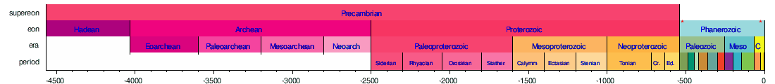


Horizontal scale is Millions of years (above timelines) / Thousands of years (below timeline)

Major proposed revisions to the ICC
Proposed Anthropocene Series/Epoch
First suggested in 2000,[61] the Anthropocene is a proposed epoch/series for the most recent time in Earth's history. While still informal, it is a widely used term to denote the present geologic time interval, in which many conditions and processes on Earth are profoundly altered by human impact.[62] As of April 2022[update] the Anthropocene has not been ratified by the ICS; however, in May 2019 the Anthropocene Working Group voted in favour of submitting a formal proposal to the ICS for the establishment of the Anthropocene Series/Epoch.[63] Nevertheless, the definition of the Anthropocene as a geologic time period rather than a geologic event remains controversial and difficult.[64][65][66][67]
Proposals for revisions to pre-Cryogenian timeline
Shields et al. 2021
An international working group of the ICS on pre-Cryogenian chronostratigraphic subdivision have outlined a template to improve the pre-Cryogenian geologic time scale based on the rock record to bring it in line with the post-Tonian geologic time scale.[6] This work assessed the geologic history of the currently defined eons and eras of the pre-Cambrian,[note 3] and the proposals in the "Geological Time Scale" books 2004,[68] 2012,[3] and 2020.[69] Their recommend revisions[6] of the pre-Cryogenian geologic time scale were (changes from the current scale [v2023/09] are italicised):
- Three divisions of the Archean instead of four by dropping Eoarchean, and revisions to their geochronometric definition, along with the repositioning of the Siderian into the latest Neoarchean, and a potential Kratian division in the Neoarchean.
- Archean (4000–2450 Ma)
- Paleoarchean (4000–3500 Ma)
- Mesoarchean (3500–3000 Ma)
- Neoarchean (3000–2450 Ma)
- Kratian (no fixed time given, prior to the Siderian) – from Greek word κράτος (krátos), meaning strength.
- Siderian (?–2450 Ma) – moved from Proterozoic to end of Archean, no start time given, base of Paleoproterozoic defines the end of the Siderian
- Archean (4000–2450 Ma)
- Refinement of geochronometric divisions of the Proterozoic, Paleoproterozoic, repositioning of the Statherian into the Mesoproterozoic, new Skourian period/system in the Paleoproterozoic, new Kleisian or Syndian period/system in the Neoproterozoic.
- Paleoproterozoic (2450–1800 Ma)
- Skourian (2450–2300 Ma) – from the Greek word σκουριά (skouriá), meaning 'rust'.
- Rhyacian (2300–2050 Ma)
- Orosirian (2050–1800 Ma)
- Mesoproterozoic (1800–1000 Ma)
- Statherian (1800–1600 Ma)
- Calymmian (1600–1400 Ma)
- Ectasian (1400-1200 Ma)
- Stenian (1200–1000 Ma)
- Neoproterozoic (1000–538.8 Ma)[note 6]
- Kleisian or Syndian (1000–800 Ma) – respectively from the Greek words κλείσιμο (kleísimo) meaning 'closure', and σύνδεση (sýndesi) meaning 'connection'.
- Tonian (800–720 Ma)
- Cryogenian (720–635 Ma)
- Ediacaran (635–538.8 Ma)
- Paleoproterozoic (2450–1800 Ma)
Proposed pre-Cambrian timeline (Shield et al. 2021, ICS working group on pre-Cryogenian chronostratigraphy), shown to scale:[note 7]

Current ICC pre-Cambrian timeline (v2023/09), shown to scale:

Van Kranendonk et al. 2012 (GTS2012)
The book, Geologic Time Scale 2012, was the last commercial publication of an international chronostratigraphic chart that was closely associated with the ICS.[2] It included a proposal to substantially revise the pre-Cryogenian time scale to reflect important events such as the formation of the Solar System and the Great Oxidation Event, among others, while at the same time maintaining most of the previous chronostratigraphic nomenclature for the pertinent time span.[70] As of April 2022[update] these proposed changes have not been accepted by the ICS. The proposed changes (changes from the current scale [v2023/09]) are italicised:
- Hadean Eon (4567–4030 Ma)
- Archean Eon/Eonothem (4030–2420 Ma)
- Paleoarchean Era/Erathem (4030–3490 Ma)
- Acastan Period/System (4030–3810 Ma) – named after the Acasta Gneiss, one of the oldest preserved pieces of continental crust.[58][71]
- Isuan Period (3810–3490 Ma) – named after the Isua Greenstone Belt.[58]
- Mesoarchean Era/Erathem (3490–2780 Ma)
- Vaalbaran Period/System (3490–3020 Ma) – based on the names of the
- Pongolan Period/System (3020–2780 Ma) – named after the Pongola Supergroup, in reference to the well preserved evidence of terrestrial microbial communities in those rocks.[58]
- Neoarchean Era/Erathem (2780–2420 Ma)
- Methanian Period/System (2780–2630 Ma) – named for the inferred predominance of methanotrophic prokaryotes[58]
- Siderian Period/System (2630–2420 Ma) – named for the voluminous banded iron formations formed within its duration.[58]
- Methanian Period/System (2780–2630 Ma) – named for the inferred predominance of
- Paleoarchean Era/Erathem (4030–3490 Ma)
- Proterozoic Eon/Eonothem (2420–538.8 Ma)[note 6]
- Paleoproterozoic Era/Erathem (2420–1780 Ma)
- Oxygenian Period/System (2420–2250 Ma) – named for displaying the first evidence for a global oxidising atmosphere.[58]
- Jatulian or Eukaryian Period/System (2250–2060 Ma) – names are respectively for the Lomagundi–Jatuli δ13C isotopic excursion event spanning its duration, and for the (proposed)[73][74] first fossil appearance of eukaryotes.[58]
- Columbian Period/System (2060–1780 Ma) – named after the supercontinent Columbia.[58]
- Mesoproterozoic Era/Erathem (1780–850 Ma)
- Paleoproterozoic Era/Erathem (2420–1780 Ma)
Proposed pre-Cambrian timeline (GTS2012), shown to scale:

Current ICC pre-Cambrian timeline (v2023/09), shown to scale:

Table of geologic time
It has been suggested that the details about life in the "Major events" column of the table be split out into another article titled Timeline of the evolutionary history of life. (Discuss) (November 2023) |
This section needs additional citations for verification. (November 2023) |
The following table summarises the major events and characteristics of the divisions making up the geologic time scale of Earth. This table is arranged with the most recent geologic periods at the top, and the oldest at the bottom. The height of each table entry does not correspond to the duration of each subdivision of time. As such, this table is not to scale and does not accurately represent the relative time-spans of each geochronologic unit. While the Phanerozoic Eon looks longer than the rest, it merely spans ~539 million years (~12% of Earth's history), whilst the previous three eons[note 3] collectively span ~3,461 million years (~76% of Earth's history). This bias toward the most recent eon is in part due to the relative lack of information about events that occurred during the first three eons compared to the current eon (the Phanerozoic).[6][75] The use of subseries/subepochs has been ratified by the ICS.[17]
The content of the table is based on the official ICC produced and maintained by the ICS who also provide an online interactive version of this chart. The interactive version is based on a service delivering a machine-readable Resource Description Framework/Web Ontology Language representation of the time scale, which is available through the Commission for the Management and Application of Geoscience Information GeoSciML project as a service[76] and at a SPARQL end-point.[77][78]
| Eonothem/ Eon |
Erathem/ Era |
System/ Period |
Series/ Epoch |
Stage/ Age |
Major events | Start, million years ago [note 8] |
|---|---|---|---|---|---|---|
| Phanerozoic | Cenozoic [note 5] |
Quaternary | Holocene | Meghalayan | CO2 .
|
0.0042 * |
| Northgrippian | 8.2-kiloyear event, Holocene climatic optimum. Sea level flooding of Doggerland and Sundaland. Sahara becomes a desert. End of Stone Age and start of recorded history. Humans finally expand into the Arctic Archipelago and Greenland. | 0.0082 * | ||||
| Greenlandian | Climate stabilises. Current Extreme North, and the Americas (mainland and the Caribbean ).
|
0.0117 ± 0.000099 * | ||||
| Pleistocene | Tarantian ')
|
Pleistocene megafauna (including the last terror birds) extinction. Humans expand into Near Oceania and the Americas .
|
0.129 | |||
| Chibanian | Homo sapiens .
|
0.774 * | ||||
| Calabrian | Further cooling of the climate. Giant terror birds go extinct. Spread of Homo erectus across Afro-Eurasia .
|
1.8 * | ||||
| Gelasian | Start of Pleistocene megafauna and Homo habilis .
|
2.58 * | ||||
| Neogene | Pliocene | Piacenzian | Greenland ice sheet develops[80] as the cold slowly intensifies towards the Pleistocene. Atmospheric O2 and CO2 content reaches present-day levels while landmasses also reach their current locations (e.g. the Isthmus of Panama joins the North and South Americas, while allowing a faunal interchange). The last non-marsupial metatherians go extinct. Australopithecus common in East Africa; Stone Age begins.[81] | 3.6 * | ||
| Zanclean | Zanclean flooding of the Mediterranean Basin. Cooling climate continues from the Miocene. First equines and elephantines. Ardipithecus in Africa.[81] | 5.333 * | ||||
| Miocene | Messinian | Moderate icehouse climate, punctuated by ice ages and re-establishment of East Antarctic Ice Sheet. Choristoderes, the last non-crocodilian crocodylomorphs and creodonts go extinct. After separating from gorilla ancestors, chimpanzee and human ancestors gradually separate; Sahelanthropus and Orrorin in Africa.
|
7.246 * | |||
| Tortonian | 11.63 * | |||||
| Serravallian | Middle Miocene climate optimum temporarily provides a warm climate. hippos. Ancestor of great apes .
|
13.82 * | ||||
| Langhian | 15.98 * | |||||
| Burdigalian | . | 20.44 | ||||
Aquitanian
|
23.03 * | |||||
| Paleogene | Oligocene | Chattian | seals). Major evolution and dispersal of modern types of flowering plants. Cimolestans, miacoids and condylarths go extinct. First neocetes (modern, fully aquatic whales) appear.
|
27.82 * | ||
| Rupelian | 33.9 * | |||||
| Eocene | Priabonian | Laramide and Sevier Orogenies of the Rocky Mountains in North America. Hellenic Orogeny begins in Greece and Aegean Sea .
|
37.71 * | |||
| Bartonian | 41.2 | |||||
| Lutetian | 47.8 * | |||||
| Ypresian | Two transient events of global warming ( North Atlantic Ocean. Maritime Southeast Asia diverges from the rest of Eurasia. First passerines, ruminants, pangolins, bats and true primates .
|
56 * | ||||
| Paleocene | Thanetian | Starts with terror birds) and mammals (up to bear or small hippo size). Alpine orogeny in Europe and Asia begins. First proboscideans and plesiadapiformes (stem primates) appear. Some marsupials migrate to Australia.
|
59.2 * | |||
| Selandian | 61.6 * | |||||
| Danian | 66 * | |||||
| Mesozoic | Cretaceous | Upper/Late | Maastrichtian | Sevier Orogenies of the Rocky Mountains. Atmospheric oxygen and carbon dioxide levels similar to present day. Acritarchs disappear. Climate initially warm, but later it cools.
|
72.1 ± 0.2 * | |
| Campanian | 83.6 ± 0.2 * | |||||
| Santonian | 86.3 ± 0.5 * | |||||
| Coniacian | 89.8 ± 0.3 * | |||||
| Turonian | 93.9 * | |||||
| Cenomanian | 100.5 * | |||||
| Lower/Early | Albian | ~113 * | ||||
| Aptian | ~121.4 | |||||
| Barremian | ~125.77 * | |||||
| Hauterivian | ~132.6 * | |||||
| Valanginian | ~139.8 | |||||
| Berriasian | ~145 | |||||
| Jurassic | Upper/Late | Tithonian | Climate becomes humid again. Crocodylomorphs (last pseudosuchians) seek out an aquatic lifestyle. Mesozoic marine revolution continues from late Triassic. Tentaculitans disappear.
|
149.2 ± 0.9 | ||
| Kimmeridgian | 154.8 ± 1.0 * | |||||
Oxfordian
|
161.5 ± 1.0 | |||||
| Middle | Callovian | 165.3 ± 1.2 | ||||
| Bathonian | 168.2 ± 1.3 * | |||||
| Bajocian | 170.9 ± 1.4 * | |||||
| Aalenian | 174.7 ± 1.0 * | |||||
| Lower/Early | Toarcian | 184.2 ± 0.7 * | ||||
| Pliensbachian | 192.9 ± 1.0 * | |||||
| Sinemurian | 199.5 ± 0.3 * | |||||
| Hettangian | 201.4 ± 0.2 * | |||||
| Triassic | Upper/Late | Rhaetian | diatoms.[87]
|
~208.5 | ||
| Norian | ~227 | |||||
| Carnian | ~237 * | |||||
| Middle | Ladinian | ~242 * | ||||
| Anisian | 247.2 | |||||
| Lower/Early | Olenekian | 251.2 | ||||
| Induan | 251.902 ± 0.024 * | |||||
| Paleozoic | Permian | Lopingian | Changhsingian | Hunter-Bowen Orogeny on Australian continent begins (c. 260–225 Ma), forming the New England Fold Belt.
|
254.14 ± 0.07 * | |
| Wuchiapingian | 259.51 ± 0.21 * | |||||
| Guadalupian | Capitanian | 264.28 ± 0.16 * | ||||
| Wordian | 266.9 ± 0.4 * | |||||
| Roadian | 273.01 ± 0.14 * | |||||
| Cisuralian | Kungurian | 283.5 ± 0.6 | ||||
| Artinskian | 290.1 ± 0.26 * | |||||
| Sakmarian | 293.52 ± 0.17 * | |||||
| Asselian | 298.9 ± 0.15 * | |||||
| Carboniferous [note 10] |
Pennsylvanian [note 11] |
Gzhelian | sharks .
|
303.7 | ||
| Kasimovian | 307 ± 0.1 | |||||
| Moscovian | 315.2 ± 0.2 | |||||
| Bashkirian | 323.2 * | |||||
| Mississippian [note 11] |
Serpukhovian | Large Tuhua Orogeny in New Zealand tapers off. Some lobe finned fish called rhizodonts become abundant and dominant in freshwaters. Siberia collides with a different small continent, Kazakhstania .
|
330.9 ± 0.2 | |||
| Viséan | 346.7 ± 0.4 * | |||||
| Tournaisian | 358.9 ± 0.4 * | |||||
| Devonian | Upper/Late
|
Famennian | First cystoids ), and fish, including all placoderms and ostracoderms.
|
372.2 ± 1.6 * | ||
| Frasnian | 382.7 ± 1.6 * | |||||
| Middle | Givetian | 387.7 ± 0.8 * | ||||
| Eifelian | 393.3 ± 1.2 * | |||||
| Lower/Early | Emsian | 407.6 ± 2.6 * | ||||
| Pragian | 410.8 ± 2.8 * | |||||
| Lochkovian | 419.2 ± 3.2 * | |||||
| Silurian | Pridoli
|
Lachlan Orogeny on Australian continent tapers off.
|
423 ± 2.3 * | |||
Ludlow
|
Ludfordian | 425.6 ± 0.9 * | ||||
| Gorstian | 427.4 ± 0.5 * | |||||
Wenlock
|
Homerian | 430.5 ± 0.7 * | ||||
| Sheinwoodian | 433.4 ± 0.8 * | |||||
Llandovery
|
Telychian | 438.5 ± 1.1 * | ||||
| Aeronian | 440.8 ± 1.2 * | |||||
| Rhuddanian | 443.8 ± 1.5 * | |||||
| Ordovician | Upper/Late | Hirnantian | The conodonts .
|
445.2 ± 1.4 * | ||
| Katian | 453 ± 0.7 * | |||||
| Sandbian | 458.4 ± 0.9 * | |||||
Middle
|
Darriwilian | 467.3 ± 1.1 * | ||||
| Dapingian | 470 ± 1.4 * | |||||
Lower/Early
|
Floian (formerly Arenig) |
477.7 ± 1.4 * | ||||
| Tremadocian | 485.4 ± 1.9 * | |||||
| Cambrian | Furongian | Stage 10 | Major diversification of (fossils mainly show bilaterian) life in the Delamerian Orogeny (c. 514–490 Ma) on Australian continent. Some small terranes split off from Gondwana. Atmospheric CO2 content roughly 15 times present-day (Holocene) levels (6000 ppm compared to today's 400 ppm)[83][note 9] Arthropods and streptophyta start colonising land. 3 extinction events occur 517, 502 & 488 Ma, the first and last of which wipe out many of the anomalocarids, artiopods, hyoliths, brachiopods, molluscs, and conodonts (early jawless vertebrates).
|
~489.5 | ||
| Jiangshanian | ~494 * | |||||
| Paibian | ~497 * | |||||
| Miaolingian | Guzhangian | ~500.5 * | ||||
| Drumian | ~504.5 * | |||||
| Wuliuan | ~509 | |||||
| Series 2 | Stage 4 | ~514 | ||||
| Stage 3 | ~521 | |||||
| Terreneuvian | Stage 2 | ~529 | ||||
| Fortunian | 538.8 ± 0.2 * | |||||
| Proterozoic | Neoproterozoic | Ediacaran | Good Pan-African Orogeny, leading to the formation of the short-lived Ediacaran supercontinent Pannotia, which by the end of the period breaks up into Laurentia, Baltica, Siberia and Gondwana. Petermann Orogeny forms on Australian continent. Beardmore Orogeny in Antarctica, 633–620 Ma. Ozone layer forms. An increase in oceanic mineral levels.
|
~635 * | ||
| Cryogenian | Possible "Snowball Earth" period. Fossils still rare. Late Ruker / Nimrod Orogeny in Antarctica tapers off. First uncontroversial animal fossils. First hypothetical terrestrial fungi[89] and streptophyta.[90] | ~720 | ||||
| Tonian | Final assembly of multi-celled eukaryotes.
|
1000 [note 12] | ||||
| Mesoproterozoic | Stenian | Narrow highly metamorphic belts due to orogeny as Rodinia forms, surrounded by the Pan-African Ocean. Sveconorwegian orogeny starts. Late Ruker / Nimrod Orogeny in Antarctica possibly begins. Musgrave Orogeny (c. 1,080–), Musgrave Block, Central Australia. Stromatolites decline as algae proliferate. | 1200 [note 12] | |||
| Ectasian | Grenville Orogeny in North America. Columbia breaks up.
|
1400 [note 12] | ||||
| Calymmian | fungi and holozoans). Acritarchs (remains of marine algae possibly) start appearing in the fossil record.
|
1600 [note 12] | ||||
| Paleoproterozoic | Statherian | First uncontroversial Yilgarn craton, in Western Australia. Mangaroon Orogeny, 1,680–1,620 Ma, on the Gascoyne Complex in Western Australia. Kararan Orogeny (1,650 Ma), Gawler Craton, South Australia . Oxygen levels drop again.
|
1800 [note 12] | |||
| Orosirian | The Gawler craton in Australian continent begins.
|
2050 [note 12] | ||||
| Rhyacian | Huronian glaciation. First hypothetical eukaryotes. Multicellular Francevillian biota . Kenorland disassembles.
|
2300 [note 12] | ||||
| Siderian | Great Oxidation Event (due to cyanobacteria) increases oxygen. Sleaford Orogeny on Australian continent, Gawler Craton 2,440–2,420 Ma. | 2500 [note 12] | ||||
| Archean | Neoarchean | Stabilization of most modern prokaryotes .
|
2800 [note 12] | |||
| Mesoarchean | First stromatolites (probably colonial phototrophic bacteria, like cyanobacteria). Oldest macrofossils. Humboldt Orogeny in Antarctica. Blake River Megacaldera Complex begins to form in present-day Ontario and Quebec, ends by roughly 2,696 Ma. | 3200 [note 12] | ||||
| Paleoarchean | Prokaryotic microbial mats. Oldest cratons on Earth (such as the Canadian Shield and the Pilbara Craton) may have formed during this period.[note 13] Rayner Orogeny in Antarctica.
|
3600 [note 12] | ||||
| Eoarchean | First uncontroversial Orogeny in Antarctica, 4,000 ± 200 Ma. | 4031 [note 12] | ||||
| Hadean | Formation of giant impact . Formation of Earth (4,543 to 4,540 Ma)
|
4567.3 ± 0.16 [note 12] | ||||
Non-Earth based geologic time scales
Lunar (selenological) time scale
The geologic history of Earth's Moon has been divided into a time scale based on geomorphological markers, namely impact cratering, volcanism, and erosion. This process of dividing the Moon's history in this manner means that the time scale boundaries do not imply fundamental changes in geological processes, unlike Earth's geologic time scale. Five geologic systems/periods (Pre-Nectarian, Nectarian, Imbrian, Eratosthenian, Copernican), with the Imbrian divided into two series/epochs (Early and Late) were defined in the latest Lunar geologic time scale.[95] The Moon is unique in the Solar System in that it is the only other body from which we have rock samples with a known geological context.

Martian geologic time scale
The geological history of Mars has been divided into two alternate time scales. The first time scale for Mars was developed by studying the impact crater densities on the Martian surface. Through this method four periods have been defined, the Pre-Noachian (~4,500–4,100 Ma), Noachian (~4,100–3,700 Ma), Hesperian (~3,700–3,000 Ma), and Amazonian (~3,000 Ma to present).[96][97]

A second time scale based on mineral alteration observed by the OMEGA spectrometer on-board the Mars Express. Using this method, three periods were defined, the Phyllocian (~4,500–4,000 Ma), Theiikian (~4,000–3,500 Ma), and Siderikian (~3,500 Ma to present).[98]

See also
- Age of the Earth
- Cosmic calendar
- Deep time
- Evolutionary history of life
- Formation and evolution of the Solar System
- Geological history of Earth
- Geology of Mars
- Geon (geology)
- Graphical timeline of the universe
- History of Earth
- History of geology
- History of paleontology
- List of fossil sites
- List of geochronologic names
- Logarithmic timeline
- Lunar geologic timescale
- Martian geologic timescale
- Natural history
- New Zealand geologic time scale
- Prehistoric life
- Timeline of the Big Bang
- Timeline of evolution
- Timeline of the geologic history of the United States
- Timeline of human evolution
- Timeline of natural history
- Timeline of paleontology
Notes
- ^ It is now known that not all sedimentary layers are deposited purely horizontally, but this principle is still a useful concept.
- ^ Time spans of geologic time units vary broadly, and there is no numeric limitation on the time span they can represent. They are limited by the time span of the higher rank unit they belong to, and to the chronostratigraphic boundaries they are defined by.
- ^ a b c Precambrian or pre-Cambrian is an informal geological term for time before the Cambrian period
- ^ This denomination of time is not universally recognized by geologists
- ^ a b The Tertiary is a now obsolete geologic system/period spanning from 66 Ma to 2.6 Ma. It has no exact equivalent in the modern ICC, but is approximately equivalent to the merged Palaeogene and Neogene systems/periods.
- ^ a b Geochronometric date for the Ediacaran has been adjusted to reflect ICC v2023/09 as the formal definition for the base of the Cambrian has not changed.
- ^ Kratian time span is not given in the article. It lies within the Neoarchean, and prior to the Siderian. The position shown here is an arbitrary division.
- ^ The dates and uncertainties quoted are according to the International Commission on Stratigraphy International Chronostratigraphic chart (v2023/06). A * indicates boundaries where a Global Boundary Stratotype Section and Point has been internationally agreed.
- ^ Carbon dioxide in the Earth's atmosphere, and climate change. Specific graphs of reconstructed CO2 levels over the past ~550, 65, and 5 million years can be seen at File:Phanerozoic Carbon Dioxide.png, File:65 Myr Climate Change.png, File:Five Myr Climate Change.png, respectively.
- ^ The Mississippian and Pennsylvanian are official sub-systems/sub-periods.
- ^ a b This is divided into Lower/Early, Middle, and Upper/Late series/epochs
- ^ a b c d e f g h i j k l m Defined by absolute age (Global Standard Stratigraphic Age).
- ^ The age of the oldest measurable craton, or continental crust, is dated to 3,600–3,800 Ma.
- ^ Not enough is known about extra-solar planets for worthwhile speculation.
References
- ^ a b c "Statues & Guidelines". International Commission on Stratigraphy. Retrieved 5 April 2022.
- ^ S2CID 51819600.
- ^ ISBN 978-0-444-59425-9, retrieved 5 April 2022
- ^ "International Commission on Stratigraphy". International Geological Time Scale. Retrieved 5 June 2022.
- ^ S2CID 130092094.
- ^ S2CID 236285974.
- ^ a b Steno, Nicolaus (1669). Nicolai Stenonis de solido intra solidvm natvraliter contento dissertationis prodromvs ad serenissimvm Ferdinandvm II ... (in Latin). W. Junk.
- ^ a b Hutton, James (1795). Theory of the Earth. Vol. 1. Edinburgh.
- ^ a b Lyell, Sir Charles (1832). Principles of Geology: Being an Attempt to Explain the Former Changes of the Earth's Surface, by Reference to Causes Now in Operation. Vol. 1. London: John Murray.
- ^ "International Commission on Stratigraphy - Stratigraphic Guide - Chapter 9. Chronostratigraphic Units". stratigraphy.org. Retrieved 16 April 2024.
- ^ a b c d e f g h i j k l "Chapter 9. Chronostratigraphic Units". stratigraphy.org. International Commission on Stratigraphy. Retrieved 2 April 2022.
- ^ a b c "Chapter 3. Definitions and Procedures". stratigraphy.org. International Commission on Stratigraphy. Retrieved 2 April 2022.
- ^ "Global Boundary Stratotype Section and Points". stratigraphy.org. International Commission on Stratigraphy. Retrieved 2 April 2022.
- .
- ISSN 0705-3797.
- ^ OCLC 1137380460.)
{{cite book}}: CS1 maint: location missing publisher (link - ^ S2CID 240772165.
- ^ Desnoyers, J. (1829). "Observations sur un ensemble de dépôts marins plus récents que les terrains tertiaires du bassin de la Seine, et constituant une formation géologique distincte; précédées d'un aperçu de la nonsimultanéité des bassins tertiares" [Observations on a set of marine deposits [that are] more recent than the tertiary terrains of the Seine basin and [that] constitute a distinct geological formation; preceded by an outline of the non-simultaneity of tertiary basins]. Annales des Sciences Naturelles (in French). 16: 171–214, 402–491. From p. 193: "Ce que je désirerais ... dont il faut également les distinguer." (What I would desire to prove above all is that the series of tertiary deposits continued – and even began in the more recent basins – for a long time, perhaps after that of the Seine had been completely filled, and that these later formations – Quaternary (1), so to say – should not retain the name of alluvial deposits any more than the true and ancient tertiary deposits, from which they must also be distinguished.) However, on the very same page, Desnoyers abandoned the use of the term "Quaternary" because the distinction between Quaternary and Tertiary deposits wasn't clear. From p. 193: "La crainte de voir mal comprise ... que ceux du bassin de la Seine." (The fear of seeing my opinion in this regard be misunderstood or exaggerated, has made me abandon the word "quaternary", which at first I had wanted to apply to all deposits more recent than those of the Seine basin.)
- ^ d'Halloy, d'O., J.-J. (1822). "Observations sur un essai de carte géologique de la France, des Pays-Bas, et des contrées voisines" [Observations on a trial geological map of France, the Low Countries, and neighboring countries]. Annales des Mines. 7: 353–376.
{{cite journal}}: CS1 maint: multiple names: authors list (link) From page 373: "La troisième, qui correspond à ce qu'on a déja appelé formation de la craie, sera désigné par le nom de terrain crétacé." (The third, which corresponds to what was already called the "chalk formation", will be designated by the name "chalky terrain".) - ^ Humboldt, Alexander von (1799). Ueber die unterirdischen Gasarten und die Mittel ihren Nachtheil zu vermindern: ein Beytrag zur Physik der praktischen Bergbaukunde (in German). Vieweg.
- ^ Brongniart, Alexandre (1770-1847) Auteur du texte (1829). Tableau des terrains qui composent l'écorce du globe ou Essai sur la structure de la partie connue de la terre . Par Alexandre Brongniart,... (in French).
{{cite book}}: CS1 maint: numeric names: authors list (link) - ISBN 978-0-444-59425-9, retrieved 1 May 2022
- ^ Murchison; Murchison, Sir Roderick Impey; Verneuil; Keyserling, Graf Alexander (1842). On the Geological Structure of the Central and Southern Regions of Russia in Europe, and of the Ural Mountains. Print. by R. and J.E. Taylor.
- ^ Phillips, John (1835). Illustrations of the Geology of Yorkshire: Or, A Description of the Strata and Organic Remains: Accompanied by a Geological Map, Sections and Plates of the Fossil Plants and Animals ... J. Murray.
- S2CID 128475487.
- ISSN 1941-5966.
- S2CID 129165105.
- ISSN 0705-3797.
- ^ Chisholm, Hugh, ed. (1911). . Encyclopædia Britannica (11th ed.). Cambridge University Press.
- ^ Butcher, Andy (26 May 2004). "Re: Ediacaran". LISTSERV 16.0 - AUSTRALIAN-LINGUISTICS-L Archives. Archived from the original on 23 October 2007. Retrieved 19 July 2011.
- ^ "Place Details: Ediacara Fossil Site – Nilpena, Parachilna, SA, Australia". Department of Sustainability, Environment, Water, Population and Communities. Australian Heritage Database. Commonwealth of Australia. Archived from the original on 3 June 2011. Retrieved 19 July 2011.
- ^ ISSN 0950-1207.
- ^ S2CID 128604255.
- OCLC 956775994.
- OCLC 165626104.
- OCLC 11574066.
- OCLC 2233803.
- ISBN 978-3-662-55046-5, retrieved 20 April 2022
- ^ Burnet, Thomas (1681). Telluris Theoria Sacra: orbis nostri originen et mutationes generales, quasi am subiit aut olim subiturus est, complectens. Libri duo priores de Diluvio & Paradiso (in Latin). London: G. Kettiby.
- ^ Werner, Abraham Gottlob (1787). Kurze Klassifikation und Beschreibung der verschiedenen Gebirgsarten (in German). Dresden: Walther.
- ^ Moro, Anton Lazzaro (1740). De'crostacei e degli altri marini corpi che si truovano su'monti (in Italian). Appresso Stefano Monti.
- S2CID 251578886.
- ^ Hutton, James (1795). Theory of the Earth. Vol. 2. Edinburgh.
- ^ Playfair, John (1802). Illustrations of the Huttonian theory of the earth. Digitised by London Natural History Museum Library. Edinburgh: Neill & Co.
- ^ Lyell, Sir Charles (1832). Principles of Geology: Being an Attempt to Explain the Former Changes of the Earth's Surface, by Reference to Causes Now in Operation. Vol. 2. London: John Murray.
- ^ Lyell, Sir Charles (1834). Principles of Geology: Being an Inquiry how for the Former Changes of the Earth's Surface are Referrable to Causes Now in Operation. Vol. 3. London: John Murray.
- ^ Holmes, Arthur (1913). The age of the earth. Gerstein - University of Toronto. London, Harper.
- ^ S2CID 128686640.
- S2CID 3965303.
- S2CID 129166282.
- S2CID 4179334.
- ISSN 0705-3797.
- OCLC 14352783.
- OCLC 8387993.
- OCLC 20930970.
- OCLC 60770922.
- ISSN 0078-0421.
- ^ OCLC 808340848.
- ^ OCLC 949988705.
- ^ OCLC 1224105111.)
{{cite book}}: CS1 maint: location missing publisher (link - S2CID 245639062, retrieved 15 April 2022
- ^ "Working Group on the 'Anthropocene' | Subcommission on Quaternary Stratigraphy". Archived from the original on 7 April 2022. Retrieved 17 April 2022.
- S2CID 182238145.
- S2CID 244165877.
- S2CID 244145710.
- S2CID 233816527.
- S2CID 237515330.
- ISBN 978-0-521-78673-7, retrieved 9 April 2022
- S2CID 229513433, retrieved 9 April 2022
- ISBN 978-0-44-459425-9.
- ^ .
- (PDF) from the original on 19 April 2012.
- PMID 24963687.
- S2CID 4331375.[permanent dead link]
- ^ "Geological time scale". Digital Atlas of Ancient Life. Paleontological Research Institution. Retrieved 17 January 2022.
- ^ "Geologic Timescale Elements in the International Chronostratigraphic Chart". Retrieved 3 August 2014.
- ^ Cox, Simon J. D. "SPARQL endpoint for CGI timescale service". Archived from the original on 6 August 2014. Retrieved 3 August 2014.
- S2CID 42345393.
- ISSN 1543-5938. Archived from the originalon 1 May 2022. Retrieved 5 June 2022.
- .
- ^ a b Tyson, Peter (October 2009). "NOVA, Aliens from Earth: Who's who in human evolution". PBS. Retrieved 8 October 2009.
- ^ Gannon, Colin (26 April 2013). "Understanding the Middle Miocene Climatic Optimum: Evaluation of Deuterium Values (δD) Related to Precipitation and Temperature". Honors Projects in Science and Technology.
- ^ doi:10.1016/j.gca.2005.11.031. Archived from the original(PDF) on 27 September 2019. Retrieved 6 August 2015.
- ^ "Here's What the Last Common Ancestor of Apes and Humans Looked Like". Live Science. 10 August 2017.
- S2CID 4397839.
- S2CID 4326971.
- hdl:10013/epic.12689.
- PMID 31217418.
- S2CID 131775942.
- PMID 35154170.
- PMID 14963099.
- S2CID 128376754.
- ISBN 978-0-444-52810-0, retrieved 1 May 2022
- S2CID 4319774.
- doi:10.3133/pp1348.
- ISSN 0148-0227.
- ISSN 0012-821X.
- S2CID 13968348.
Further reading
- Aubry, Marie-Pierre; Van Couvering, John A.; Christie-Blick, Nicholas; Landing, Ed; Pratt, Brian R.; Owen, Donald E.; Ferrusquia-Villafranca, Ismael (2009). "Terminology of geological time: Establishment of a community standard". Stratigraphy. 6 (2): 100–105. doi:10.7916/D8DR35JQ.
- Gradstein, F. M.; Ogg, J. G. (2004). "A Geologic Time scale 2004 – Why, How and Where Next!" (PDF). Lethaia. 37 (2): 175–181. doi:10.1080/00241160410006483. Archived from the original(PDF) on 17 April 2018. Retrieved 30 November 2018.
- Gradstein, Felix M.; Ogg, James G.; Smith, Alan G. (2004). A Geologic Time Scale 2004. Cambridge, UK: Cambridge University Press. ISBN 978-0-521-78142-8. Retrieved 18 November 2011.
- Gradstein, Felix M.; Ogg, James G.; Smith, Alan G.; Bleeker, Wouter; Laurens, Lucas, J. (June 2004). "A new Geologic Time Scale, with special reference to Precambrian and Neogene". Episodes. 27 (2): 83–100. doi:10.18814/epiiugs/2004/v27i2/002.)
{{cite journal}}: CS1 maint: multiple names: authors list (link - Ialenti, Vincent (28 September 2014). "Embracing 'Deep Time' Thinking". NPR. NPR Cosmos & Culture.
- Ialenti, Vincent (21 September 2014). "Pondering 'Deep Time' Could Inspire New Ways To View Climate Change". NPR. NPR Cosmos & Culture.
- (PDF) from the original on 15 December 2011. Retrieved 18 November 2011.
- Levin, Harold L. (2010). "Time and Geology". The Earth Through Time. Hoboken, New Jersey: John Wiley & Sons. ISBN 978-0-470-38774-0. Retrieved 18 November 2011.
- Montenari, Michael (2016). Stratigraphy and Timescales (1st ed.). Amsterdam: Academic Press (Elsevier). ISBN 978-0-12-811549-7.
- Montenari, Michael (2017). Advances in Sequence Stratigraphy (1st ed.). Amsterdam: Academic Press (Elsevier). ISBN 978-0-12-813077-3.
- Montenari, Michael (2018). Cyclostratigraphy and Astrochronology (1st ed.). Amsterdam: Academic Press (Elsevier). ISBN 978-0-12-815098-6.
- Montenari, Michael (2019). Case Studies in Isotope Stratigraphy (1st ed.). Amsterdam: Academic Press (Elsevier). ISBN 978-0-12-817552-1.
- Montenari, Michael (2020). Carbon Isotope Stratigraphy (1st ed.). Amsterdam: Academic Press (Elsevier). ISBN 978-0-12-820991-2.
- Montenari, Michael (2021). Calcareous Nannofossil Biostratigraphy (1st ed.). Amsterdam: Academic Press (Elsevier). ISBN 978-0-12-824624-5.
- Nichols, Gary (2013). Sedimentology and Stratigraphy (2nd ed.). Hoboken: Wiley-Blackwell. ISBN 978-1-4051-3592-4
- Williams, Aiden (2019). Sedimentology and Stratigraphy (1st ed.). Forest Hills, NY: Callisto Reference. ISBN 978-1-64116-075-9
External links
- The current version of the International Chronostratigraphic Chart can be found at stratigraphy.org/chart
- Interactive version of the International Chronostratigraphic Chart is found at stratigraphy.org/timescale
- A list of current Global Boundary Stratotype and Section Points is found at stratigraphy.org/gssps
- NASA: Geologic Time (archived 18 April 2005)
- GSA: Geologic Time Scale (archived 20 January 2019)
- British Geological Survey: Geological Timechart
- GeoWhen Database (archived 23 June 2004)
- National Museum of Natural History – Geologic Time (archived 11 November 2005)
- SeeGrid: Geological Time Systems. Archived 23 July 2008 at the Wayback Machine. Information model for the geologic time scale.
- Exploring Time from Planck Time to the lifespan of the universe
- Episodes, Gradstein, Felix M. et al. (2004) A new Geologic Time Scale, with special reference to Precambrian and Neogene, Episodes, Vol. 27, no. 2 June 2004 (pdf)
- Lane, Alfred C, and Marble, John Putman 1937. Report of the Committee on the measurement of geologic time
- Lessons for Children on Geologic Time (archived 14 July 2011)
- Deep Time – A History of the Earth : Interactive Infographic
- Geology Buzz: Geologic Time Scale. Archived 12 August 2021 at the Wayback Machine.
| ||||||||||||||||||||||||||||||||||||||||||||||||||||||||||||

