
Essex Street, London


Essex Street is a street in the City of Westminster that runs from Milford Lane in the south to Strand in the north. It is joined by Little Essex Street on its western side and Devereux Court on the eastern side. It was laid out by Nicholas Barbon in around 1675 or 1680 and contains a number of listed buildings.
History
Essex Street was laid out by Nicholas Barbon[1] between 1675 and 1680, on the grounds of the former Essex House which itself stood on the site of the Outer Temple, once owned by the Knights Templar. The highwayman Tom Cox, who was hanged at Tyburn in 1691, was captured in the nearby St Clement Danes churchyard after one of his victims spotted him coming out of his lodgings in Essex Street.[2]
In the first half of the twentieth century, the street was known for its publisher's offices such as
Buildings
Essex Hall, an office building at numbers 1 to 6, is the headquarters of the British Unitarians.[4] Prior to the Blitz, a chapel and meeting rooms were on the site, continuing the association with the first avowedly Unitarian place of worship in London, dating back to 1774,[1] when Theophilus Lindsey founded the Essex Street Chapel.[5]
23 Essex Street houses a firm of legal barristers.[6]
The Edgar Wallace, a public house at No. 40, is on the site of the former Essex Head Tavern,[1] where Samuel Johnson and Richard Brocklesby founded the Essex Head Club in 1783.[7]
There are a number of
Little Essex Street
The Cheshire Cheese, a public house at 5 Little Essex Street, stands on a site where there has been a tavern since the 16th century.[1] It is a Grade II listed building, which was rebuilt in 1928 by the architect Nowell Parr, on the site of an earlier pub, for the 'Style & Winch' Brewery.[9]
Notable former residents
- Sir Orlando Bridgeman, member, House of Commons and Lord Keeper of the Great Seal
- Brass Crosby, radical lawyer, member of Parliament and Lord Mayor of London
- Tom Jones[1]
- James Savage, architect, had his offices in the street[1]
Gallery
-
 Map by Wenceslaus Hollar (c. 1677) showing Essex House and grounds before Essex Street was laid out
 -
 London County Council plaque on Essex Hall at 7 Essex Street
 -
 The Cheshire Cheese in Little Essex Street
 -
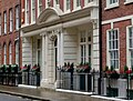 Nr. 20 Essex Street doubled as Bertram's Hotel in the 1987 Miss Marple episode "At Bertram's Hotel"
 -
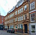 California House
 -
 Essex Street south end with the water gate at the end
 -
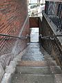 The Essex Street steps at the south end


.jpg)


References
- ^ ISBN 978-0-230-73878-2.
- ISBN 978-1-136-48416-2.
- ^ ISBN 0713401419
- ^ "Contact us". Unitarians.org.uk. Retrieved 18 February 2017.
- ^ Walford, Edward. (1878) Old and New London: A narrative of its history, its people, and its places. London: Cassell Petter & Galpin. British History Online. Retrieved 14 December 2016.
- ^ 23 Essex Street Chambers, accessed 16 December 2022
- Oxford Dictionary of National Biography, Oxford University Press, 2004-2016. Retrieved 17 November 2016. (subscription required)
- ^ Historic England. "Essex Watergate Closing South End of Street (1066823)". National Heritage List for England. Retrieved 17 November 2016.
- ^ Historic England. "Cheshire Cheese Public House (1431970)". National Heritage List for England. Retrieved 17 November 2016.
External links
 Media related to Essex Street, London EC2 at Wikimedia Commons
 The full text of A Letter from Thomas Lawrence, M. D. to William Heberden, M. D. and F. R. S. concerning the Effects of Lightning, in Essex-street, on the 18th of June, 1764 at Wikisource
- The Diamond Maker by H G Wells