
Etowah Indian Mounds
Etowah Mounds | |
Cartersville, GA | |
| Coordinates | 34°7′30.47″N 84°48′27.59″W / 34.1251306°N 84.8076639°W |
|---|---|
| NRHP reference No. | 66000272 |
| Significant dates | |
| Added to NRHP | October 15, 1966[1] |
| Designated NHL | July 19, 1964[2] |
Etowah Indian Mounds (9BR1) are a 54-acre (220,000 m2) archaeological site in Bartow County, Georgia, south of Cartersville. Built and occupied in three phases, from 1000–1550 CE, the prehistoric site is located on the north shore of the Etowah River.
Etowah Indian Mounds Historic Site is a designated National Historic Landmark, managed by the Georgia Department of Natural Resources. It is considered "the most intact Mississippian culture site in the Southeast", according to Georgia State Parks and Historic Sites.[3] Both the historic Muscogee Creek and the Cherokee peoples, who each occupied this area at varying times, hold the site to be sacred.
History
This site was professionally excavated beginning in the early 20th century. Additional studies have been undertaken as more evidence and knowledge has accumulated about the succession of cultures in this area, aided by modern technology such as radio carbon dating and magnetometers.
Late 20th-century studies showed the mounds were built and occupied by prehistoric
Etowah is a Muskogee word derived from italwa, meaning "town". From 1000–1550 CE, during the Mississippian culture era, Etowah was occupied by a series of cycling chiefdoms (see Coosa confederacy) over the course of five and a half centuries.[6] The Hernando de Soto expedition encountered a settlement called Itaba between Coosa and Ulibahali, which was likely Etowah.[7] The historic Muscogee Creek formed in this region and occupied this area. They were later pushed out by the Cherokee, who migrated from eastern Georgia and Tennessee to evade European-American pressure.
In the 19th century, European-American settlers mistakenly believed that the mounds had been built by the historic
In the 21st century, the federally recognized
Site chronology
| Period | Regional periods | Dates | Etowah Site Phases | Ceramic markers |
|---|---|---|---|---|
| Early Mississippian | Etowah Phase | 1000–1100 CE | Early Etowah | ladder base diamond predominant motif, shell tempering more common |
| 1100–1200 CE | Late Etowah | 2-bar diamond motif more prevalent, grit tempering more common, filfot cross, Etowah Incised and Hiwassee Island red on buff first appear | ||
| Middle Mississippian | Savannah Phase | 1200–1250 CE | Unoccupied | no inhabited sites along Etowah river valley |
| 1250–1325 CE | Early Wilbanks | coarse grit temper commonest, pottery thicker, bolder and with sloppier, complicated, stamped designs | ||
| 1325–1375 CE | Late Wilbanks | thinner pottery, more finely done stamping, minority vessel forms and designs appear, Rudder Comb Incised, Dallas Incised, Pisgah-like and Lake Jackson decorated | ||
| Late Mississippian | Lamar phase
|
1375–1425 CE | Stamp Creek | lack of Lamar Incised, rim modifications appear, |
| 1425–1475 CE | Mayes(provisional) | wider rims than previous phase, boldly executed 3-line incised designs | ||
| 1475–1550 CE | Brewster | narrower incised lines, stamping sloppy with most motifs no longer distinguishable, rectilinear designs common, Brewster and Barnett are temporally equivalent and are more of a geographic distinction in the valley | ||
| 1500–1625 CE | Barnett | higher percentage of shell tempering than Brewster with types such as Dallas Plain, Dallas Incised and Dallas Filleted |
Site description


Etowah has three main platform mounds and three lesser mounds. The Temple Mound, Mound A, is 63 feet (19 m) high, taller than a six-story building, and covers 3 acres (12,000 m2) at its base. In 2005–2008 ground mapping with magnetometers revealed new information and data, showing that the site was much more complex than had previously been believed.[10]
The study team has identified a total of 140 buildings on the site. In addition, Mound A was found to have had four major structures and a courtyard during the height of the community's power.
When visiting the Etowah Mounds, guests can view the "borrow pits" (which archaeologists at one time thought were moats), where workers dug earth to construct the three large mounds in the center of the park.
Older pottery found on the site suggest that there was an earlier village (c. 200 BCE–600 CE) associated with the Swift Creek culture. This earlier Middle Woodland period occupation at Etowah may have been related to the major Swift Creek center of Leake Mounds, approximately two miles downstream (west) of Etowah.
War was commonplace; many archaeologists believe the people of Etowah battled for hegemony over the
Artifacts

The artifacts discovered in burials within the Etowah site indicate that its residents developed an artistically and technically advanced culture. Numerous copper tools, weapons and ornamental copper plates accompanied the burials of members of Etowah's elite class. Where proximity to copper protected textile fibers from degeneration, archaeologists also found brightly colored cloth with ornate patterns. These were the remnants of the clothing of social elites.
Numerous clay figurines and ten
Trade
The
riverbed soil could be easily tilled with digging sticks and stone and shell hoes. Its fertility was annually renewed by the river's floods. Free of frost most of the year, the land yielded rich harvests of corn, beans, and squash, traditional crops of the indigenous peoples.Habitat
River shoals abounded in
Post-contact
Until studies of the late 20th century were published, most European-American people in Georgia believed Etowah to have been built by the well-known historic
Since that time, the Creek descendants have formed two federally recognized tribes: the largest is the
History of excavation and studies


Missionary Elias Cornelius visited the site in 1817 and described it in his journal published by Bela Bates Edwards in 1833. He realized a mound must have been over two hundred years old, due to the size of trees growing on it, but had little idea of its real history.[18] Cyrus Thomas and John P. Rogan tested the site in 1883 for the Smithsonian Institution, which was conducting a survey of recognized mound sites.
The first well-documented archaeological inquiry at the site did not begin until the winter of 1925, conducted by
Arthur R. Kelly, founding chairman of the Department of Anthropology at the University of Georgia, also conducted professional excavations and studies at Etowah Mounds, prior to planned flood control projects in the area. In 1947, the government built the Allatoona Dam upstream for flood control. The Etowah site was designated as a National Historic Landmark in 1964.
The Etowah Indian Mounds museum displays artifacts found at the site, including Mississippian culture pottery, monolithic stone axes, Mississippian stone statuary, copper jewelry, shell gorgets, and other artifacts.
Gallery
-
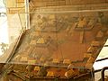 Model of Etowah at its height
 -
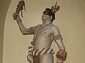 Statue of Etowah chief, Georgia State Capitol, based on archaeological findings and the descriptions of early European explorers
 -
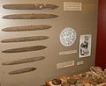 Ceremonial flint blades and chunkey stones
 -
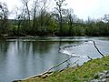 Rock fishing weir constructed on the Etowah River
 -
 Mounds B, and C from the top of Mound A.


See also
- Ocmulgee Mounds National Historical Park (Bibb County, Georgia)
- Kolomoki Mounds
- Leake Mounds (9BR2)
- Wilbanks Site
- Southeastern Ceremonial Complex
- List of Mississippian sites
- Funk Heritage Center
- List of National Historic Landmarks in Georgia (U.S. state)
- National Register of Historic Places listings in Bartow County, Georgia
Further reading
- Squier, Ephraim George and Edwin Hamilton Davis. Ancient Monuments of the Mississippi Valley. pp. 232–235.
Notes
- ^ "National Register Information System". National Register of Historic Places. National Park Service. March 15, 2006.
- ^ "Etowah Mounds". National Historic Landmark summary listing. National Park Service. Archived from the original on January 31, 2009. Retrieved June 20, 2008.
- ^ "Etowah Indian Mounds, state Historic Site, Cartersville". Georgia State Parks and Historic Sites. n.d. Retrieved November 9, 2020.
- ^ "Southeastern Prehistory:Mississippian and Late Prehistoric Period". National Park Service. Archived from the original on June 7, 2008. Retrieved April 10, 2012.
- ^ Theodore Isham; Blue Clark. "Creek (Mvskoke)". Encyclopedia of Oklahoma History & Culture. Archived from the original on July 20, 2010. Retrieved July 27, 2010.
- ^ Snow, Dean (2010). "Etowah". Archaeology Of Native North America. Prentice Hall.
- ^ ISBN 978-0-8130-1811-9.
- ^ ISBN 0-16-072300-0.
- ^ ISBN 978-0-8173-1224-4.
- ^ a b c Mike Toner (November–December 2008). "City Beneath the Mounds: Mapping a prehistoric American metropolis". Archaeology. 61 (6). Retrieved July 27, 2010.
- ^ Townsend and Sharp 151
- ISBN 978-0-8173-5465-7.
- ^ George E. Stuart (October 1981). "Etowah: A Southeastern village in 1491". National Geographic. 180 (4).
- ^ "Notice of Inventory Completion: Georgia Department of Natural Resources, Atlanta, GA". National Park Service. March 2, 2009. Retrieved September 16, 2010.
- ^ "Etowah Indian Mounds State Park", Informational Guide, Georgia Department of Natural Resources
- ^ "Etowah Indian Mounds (US)". Open Archaeology. EXARC. Retrieved November 7, 2016.
- ^ Townsend and Sharp 154
- ^ Bela Bates Edwards (1842) [1833]. Memoir of the Rev. Elias Cornelius. Boston: Perkins & Marvin. pp. 80–85.
References
- Hudson, Charles; Marvin Smith; David Hally; Richard Polhemus; Chester DePratter (1985). "Coosa: A Chiefdom in the Sixteenth-Century Southeastern United States". American Antiquity. 50 (4): 723–737. S2CID 162149464.
- Townsend, Richard F.; Sharp, Robert V., eds. (2004). Hero, Hawk, and Open Hand: American Indian Art of the Ancient Midwest and South. New Haven: Yale University Press. ISBN 0-300-10601-7.
- Warren King Moorehead, ed. (1932). Explorations of the Etowah Site in Georgia: The Etowah Papers. New Haven, CT: Yale University Press.
- Snow, Dean (2010). "Etowah". Archaeology Of Native North America. Prentice Hall.
External links
- Etowah Indian Mounds Historic Site, official site
- Etowah Mounds near Cartersville, Georgia Archived April 2, 2013, at the Wayback Machine
- "Etowah: Remote sensing" , Archaeology magazine
- Etowah (Tumlin) Mounds historical marker
- Video of the site from the ground and the top of the largest mound made by a member of the Cherokee Nation from 2016