
Europa Island
You can help expand this article with text translated from the corresponding article in French. (November 2019) Click [show] for important translation instructions.
|
Europa Island Île Europa (French) | |
|---|---|
 Flag | |
| Motto: Liberté, égalité, fraternité | |
| Anthem: "La Marseillaise" |
| Disputed island | |
|---|---|
 Map of the Scattered Islands in the Indian Ocean (Europa Island in the southwest, marked by its French name Île Europa) | |
| Geography | |
| Location | Mozambique Channel |
| Coordinates | 22°22′S 40°22′E / 22.367°S 40.367°E |
| Administration | |
| Overseas territory | French Southern and Antarctic Lands |
| District | Scattered Islands in the Indian Ocean |
| Claimed by | |
Europa Island (French: Île Europa, pronounced [il øʁɔpa]), in Malagasy Nosy Ampela[1] is a 28-square-kilometre (11 sq mi) low-lying tropical atoll in the Mozambique Channel, about a third of the way from southern Madagascar to southern Mozambique. The island had never been inhabited until 1820, when the French family of Rosier[who?] moved to it. The island officially became a possession of France in 1897.
The island, garrisoned by a detachment from
Europa Island was the setting of "Search in the Deep", a 1968 episode of The Undersea World of Jacques Cousteau,[2] partly focusing on the breeding habits of the green sea turtle.
Description
Europa is 6 kilometres (3.7 mi) in diameter, with a maximum altitude of 6 metres (20 ft), and has 22.2 kilometres (13.8 mi) of coastline. It is surrounded by coral beaches and a fringing reef and encloses a mangrove lagoon of around 9 square kilometres (3.5 sq mi) and open to the sea on one side.
There are no ports or harbours but anchorage is possible offshore. Its
Ecology
| Designations | |
|---|---|
| Official name | Île d’Europa |
| Designated | 27 October 2011 |
| Reference no. | 2073[3] |
The island is a
The island has been identified as an
Europa is home to an endemic subspecies of
Climate
Europa Island's climate is affected by the Agulhas Current with water temperatures usually above 30 °C (86 °F), southeast trade winds during the (austral) winter and occasional cyclones. The climate can be described as a semi-arid and tropical combination with wet summers and dry winters.
| Climate data for Europa Island | |||||||||||||
|---|---|---|---|---|---|---|---|---|---|---|---|---|---|
| Month | Jan | Feb | Mar | Apr | May | Jun | Jul | Aug | Sep | Oct | Nov | Dec | Year |
| Record high °C (°F) | 35.5 (95.9) |
34.4 (93.9) |
35.0 (95.0) |
32.4 (90.3) |
31.2 (88.2) |
29.2 (84.6) |
30.0 (86.0) |
29.4 (84.9) |
34.0 (93.2) |
33.7 (92.7) |
34.3 (93.7) |
33.4 (92.1) |
35.5 (95.9) |
| Mean daily maximum °C (°F) | 30.8 (87.4) |
31.2 (88.2) |
30.6 (87.1) |
29.2 (84.6) |
27.6 (81.7) |
26.1 (79.0) |
25.6 (78.1) |
26.2 (79.2) |
27.1 (80.8) |
28.4 (83.1) |
29.3 (84.7) |
30.2 (86.4) |
28.5 (83.3) |
| Daily mean °C (°F) | 27.5 (81.5) |
27.6 (81.7) |
27.0 (80.6) |
25.6 (78.1) |
23.5 (74.3) |
22.0 (71.6) |
21.6 (70.9) |
22.0 (71.6) |
22.7 (72.9) |
24.2 (75.6) |
25.3 (77.5) |
26.6 (79.9) |
24.7 (76.5) |
| Mean daily minimum °C (°F) | 24.1 (75.4) |
24.3 (75.7) |
23.6 (74.5) |
21.8 (71.2) |
19.7 (67.5) |
18.4 (65.1) |
17.7 (63.9) |
17.7 (63.9) |
18.7 (65.7) |
20.5 (68.9) |
21.8 (71.2) |
23.1 (73.6) |
20.9 (69.6) |
| Record low °C (°F) | 18.8 (65.8) |
19.1 (66.4) |
17.3 (63.1) |
15.6 (60.1) |
12.2 (54.0) |
10.2 (50.4) |
10.5 (50.9) |
11.1 (52.0) |
11.7 (53.1) |
12.4 (54.3) |
12.2 (54.0) |
15.0 (59.0) |
10.2 (50.4) |
| Average precipitation mm (inches) | 130 (5.1) |
104 (4.1) |
62 (2.4) |
28 (1.1) |
24 (0.9) |
18 (0.7) |
11 (0.4) |
10 (0.4) |
9 (0.4) |
7 (0.3) |
30 (1.2) |
129 (5.1) |
562 (22.1) |
| Average precipitation days (≥ 0.1 mm) | 10 | 8 | 8 | 5 | 5 | 5 | 4 | 3 | 3 | 2 | 4 | 9 | 65 |
| Average relative humidity (%)
|
80 | 81 | 78 | 76 | 76 | 76 | 76 | 77 | 77 | 77 | 78 | 79 | 78 |
| Mean monthly sunshine hours | 275.9 | 257.1 | 275.9 | 255.0 | 272.8 | 246.0 | 263.5 | 288.3 | 276.0 | 300.7 | 291.0 | 272.8 | 3,275 |
| Mean daily sunshine hours | 8.9 | 9.1 | 8.9 | 8.5 | 8.8 | 8.2 | 8.5 | 9.3 | 9.2 | 9.7 | 9.7 | 8.8 | 9.0 |
| Source: Deutscher Wetterdienst[6] | |||||||||||||
History
While the island has probably been sighted by navigators since at least the 16th century, it takes its name from the British ship Europa, which visited it in December 1774. Ruins and graves on Europa island attest to several attempts at settlement from the 1860s to the 1920s. For example, the French Rosiers family moved to the island in 1860, but subsequently abandoned it.[7]
-
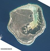 Satellite photo of Europa Island (north at top)
 -
 Map of Europa Island
 -
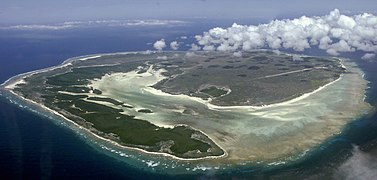 Aerial view of the island
 -
 Beaches, north of the island


References
- ^ "Le président Macron envoie l'Armée française sur les îles éparses". KoolSaina. July 27, 2021.
- ^ "The Undersea World of Jacques Cousteau - Collection One". DocuWiki. 2013-11-10. Retrieved 2014-01-07.
- ^ "Île d'Europa". Ramsar Sites Information Service. Retrieved 25 April 2018.
- ^ BirdLife International. (2012). Important Bird Areas factsheet: Europa. Downloaded from "BirdLife International - conserving the world's birds". Archived from the original on 2007-07-10. Retrieved 2014-03-29. on 2012-01-07.
- ^ C. van Herrewege. 1973. Contribution à l'étude des Blattaria de la faune Malgache. II. Description de huit espèces nouvelles appartenant aux genres Gromphadorhina Brunner v.W. et Elliptorhina gen. nov. Bulletin de la Société Linnéenne de Lyon, 42nd année, Numéro spécial du 150th anniversaire, décembre 1973. 75-103
- ^ "Klimatafel von Europa (Insel), Iles Desirades / Indischer Ozean / Frankreich" (PDF). Baseline climate means (1961-1990) from stations all over the world (in German). Deutscher Wetterdienst. Retrieved 5 April 2017.
- ^ "Europa". Districts - îles Eparses. Terres australes et antarctiques françaises. 2010. Archived from the original on 2012-01-31.
Further reading
- Warne, Kennedy (April 2014). "A tale of two atolls". National Geographic. pp. 62–75.
External links
 Media related to Europa Island (category) at Wikimedia Commons