
Fairfield Park Precinct
| Fairfield Park | |
|---|---|
sports ground, nature reserve | |
| Location | Fairfield |
| Coordinates | 33°52′28″S 150°57′34″E / 33.8744°S 150.9595°E |
| Area | 18 hectares (44.48 acres) |
| Operated by | Fairfield City Council |
| Status | Open all year |
Fairfield Park Precinct, or Fairfield Park, is an
Facilities
The park contains several recreation and sporting attractions such as Fairfield Bowling Club,
The park also features Fairfield Youth and Community Centre, a large hall which opened in October 2015, that contains
Geography

Indigenous trees and shrubs are plenteous in the park, which are a remnant of the
All in all being 18 hectares (44.48 acres) in size, the park proper (which excludes the area south of Prospect Creek, around Orphan School Creek) is around 12 hectares (29.65 acres) in size. Hypothetically, if Makepeace Oval, a sports field across the road to the northeast, was included within the park's precinct, then the overall size of the parkland will be approximately 21 hectares (51.89 acres).[7]
Transport
The park is situated on Vine Street and is only a 10-minute walk from Fairfield railway station. It contains a number of walkways and cycleways, namely near Prospect Creek, which link it to Carramar to the south and Fairfield East to the east. The Horsley Drive is a major arterial road on the east side of the parkland. There is also an entry to the park from Haughton Street in Carramar to the south, via a walk/cycleway, adjoining Heiden Park to the west.[8]
Heritage
Honour Avenue, situated on the entrance of Fairfield Park, is a memorial gateway that commemorates Australia's involvement in various 20th century wars. It was built in honour of the Fairfield residents who served in the
Crime
In February 2013, a body of a young man, a
Gallery
-
 Honour Avenue acts as the main entrance to the park.
 -
 Prospect Creek
 -
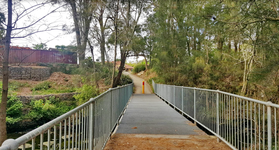 The pedestrian bridge over the creek
 -
 A seating area within the woodland
 -
 Entrance from the southern end of the park, in Haughton Street Carramar
 -
 The park's open grassland


See also
- Brenan Park
- Rosford Street Reserve
- Bland Oak, a historical tree just to the south of the park's borders
References
- ^ King Michael & Associates (1997) Recreation Needs Assessment Study prepared for Fairfield City Council
- ^ Fairfield City Council (December 1999) Vision for Fairfield Fairfield City Council
- ^ Obstacle course at Fairfield Park
- ^ "Fairfield Adventure Park". Archived from the original on 20 December 2016. Retrieved 22 October 2018.
- ^ Fairfield City Council (1999) Management Plan for Fairfield City 1999-2003 Fairfield City Council
- ^ Fairley A and Moore P (1995) Native Plants of Sydney District – an identification guide Kangaroo Press, Sydney
- ^ Clouston (1999) Fairfield Open Space Strategy prepared for Fairfield City Council
- ^ Fairfield City Council (1994) Local Environment Plan Fairfield City Council
- ^ "Fairfield City Centre Development Control Plan" (PDF). Archived from the original (PDF) on 17 April 2018. Retrieved 22 October 2018.
- ^ Police investigate drug links to Fairfield and Cabramatta murders by The Daily Telegraph, November 3, 2016
- ^ Two bodies discovered in separate incidents in Fairfield and Mt Druitt by News.com.au
- Sydney Morning Herald