
Falmouth, Maine
Falmouth, Maine | ||
|---|---|---|
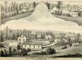
 Casco Bay in 1910 | ||
|
FIPS code 23-24495 | | |
| GNIS feature ID | 0582472 | |
| Website | www | |
Falmouth is a
A northern suburb of Portland, Falmouth borders Casco Bay and offers one of the largest anchorages in Maine. The town is home to three private golf clubs and the Portland Yacht Club.
History
Native Americans
Native Americans followed receding glaciers into Maine around 11,000 BCE. At the time of European contact in the sixteenth century, people speaking a western dialect of the Wabanaki language inhabited present-day Falmouth. Captain John Smith observed a semi-autonomous band known as the Aucocisco living in Casco Bay. English explorer Christopher Levett met with the Aucocisco Sagamore Skittery Gusset at his summer village at the Presumpscot Falls in 1623.
A combination of warfare and disease decimated Native peoples in the years before English colonization, creating a shatter zone of devastation and political instability in what would become southern Maine. The introduction of European wares in the 1500s reoriented long-standing Native trade relationships in the
New Casco (1630–1765)
Falmouth's original bounds encompassed the present day cities of Portland, South Portland, Westbrook and Cape Elizabeth. Today’s town was known as New Casco, and was only a neighborhood within the larger collection of communities around Casco Bay centered in what is downtown Portland. Falmouth’s early years were marked by extreme violence as it lay on a borderland zone between Europeans and Native Americans. Casco Bay represented the northernmost point of English settlement on the east coast until 1713. Numerous wars between 1675–1763 among the English, French, and Native Americans rarely left Falmouth unscathed from the violence. The English twice abandoned Casco Bay altogether under pressure from French and Indian attacks in 1676 and 1690.

The first European resident was Arthur Mackworth, who lived on the east bank of the Presumpscot River as early as 1630. When the
One of the earliest structures in the town of Falmouth was a palisaded fort and trading post named Fort Casco built in 1698 at the conclusion of King William's War. The location of the fort can be found today opposite Pine Grove Cemetery on Route 88. Massachusetts built the fort at the behest of local Abenaki desiring a convenient place to trade and repair tools and weapons. A 1701 meeting between the Wabanaki leaders and Massachusetts officials cemented an alliance between the two. A pair of stone cairns were then erected to symbolize the new partnership. The nearby Two Brothers Islands later received their name from this now long-forgotten monument.[5]
Unfortunately this peace would last less than three years, with the inauguration of
New Casco could not be safely settled by the English until the
Modern Falmouth
In 1765 Cape Elizabeth (then including South Portland) seceded from Falmouth. In 1786, Portland broke away, followed in 1814 by Westbrook, although boundaries between it and Falmouth were readjusted throughout the nineteenth century. Logistics were the reason these separations. Population had grown by the 1760s to the extent that separate church parishes had formed, creating rival communities more attuned to local concerns. People also complained about the distance between outer areas and the center of the town in present-day Portland. By 1859,

The extension of trolley service from Portland to the Falmouth Foreside in 1898 initiated the town's transformation from a rural community to an urban consumer society. Trolleys cemented Falmouth’s economic connection to Portland and transformed the Foreside neighborhood into a relaxation spot for nearby city dwellers. Portland’s Yankee elites relocated the Portland Yacht Club and Portland Country Club to Falmouth in 1885 and 1913 respectively, where they have remained ever since. To promote its line, the
In 1943,
The advent of the automobile accelerated Falmouth's transition toward becoming a residential suburb of Portland. Military personnel who moved to the town while Casco Bay was base Sail for America’s destroyer fleet from 1941 to 1944 bolstered much of this growth. Like many urban areas in the United States during the mid-twentieth century, the automobile, cheaper residential taxes, and the desire for open space channeled an urban exodus away from cities like Portland into neighboring towns such as Falmouth. In the span of fifty years the town’s population has skyrocketed from five thousand to over ten thousand residents today. Falmouth’s location on the ocean, along with its respected public school system, has made it one of the more attractive communities in Greater Portland. This demand consequently led developers to construct two additional country clubs in 1986 and 1988. The nature of such enclosed neighborhoods and other high-scale subdivisions like it has only recently turned the town into one of the most affluent in Maine.[11]
-
 West Falmouth Manufacturing Company, 1880.
 -
 Downtown West Falmouth, 1880.
 -
 Portland Yacht Club House c. 1894
 -
 Presumpscot River c. 1910
 -
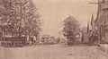 West Falmouth in 1917


Geography
According to the United States Census Bureau, the town has a total area of 36.34 square miles (94.12 km2), of which 29.38 square miles (76.09 km2) is land and 6.96 square miles (18.03 km2) is water.[1] Located beside Casco Bay, the Gulf of Maine and Atlantic Ocean, Falmouth is drained by the Presumpscot River.
The town is crossed by
Demographics
| Census | Pop. | Note | %± |
|---|---|---|---|
| 1790 | 2,994 | — | |
| 1800 | 3,422 | 14.3% | |
| 1810 | 4,105 | 20.0% | |
| 1820 | 1,679 | −59.1% | |
| 1830 | 1,966 | 17.1% | |
| 1840 | 2,071 | 5.3% | |
| 1850 | 2,157 | 4.2% | |
| 1860 | 1,935 | −10.3% | |
| 1870 | 1,730 | −10.6% | |
| 1880 | 1,622 | −6.2% | |
| 1890 | 1,580 | −2.6% | |
| 1900 | 1,511 | −4.4% | |
| 1910 | 1,488 | −1.5% | |
| 1920 | 1,542 | 3.6% | |
| 1930 | 2,041 | 32.4% | |
| 1940 | 2,883 | 41.3% | |
| 1950 | 4,342 | 50.6% | |
| 1960 | 5,976 | 37.6% | |
| 1970 | 6,291 | 5.3% | |
| 1980 | 6,853 | 8.9% | |
| 1990 | 7,610 | 11.0% | |
| 2000 | 10,310 | 35.5% | |
| 2010 | 11,185 | 8.5% | |
| 2020 | 12,444 | 11.3% | |
| Sources:[12] | |||
As of 2000 the median income for a household in the town was $66,855, and the median income for a family was $87,304. Males had a median income of $54,545 versus $35,258 for females. The
2010 census
As of the
There were 4,334 households, of which 36.5% had children under the age of 18 living with them, 60.9% were married couples living together, 6.7% had a female householder with no husband present, 3.1% had a male householder with no wife present, and 29.3% were non-families. 24.0% of all households were made up of individuals, and 12.8% had someone living alone who was 65 years of age or older. The average household size was 2.54 and the average family size was 3.05.
The median age in the town was 45.3 years. 25.9% of residents were under the age of 18; 4.3% were between the ages of 18 and 24; 19.2% were from 25 to 44; 33.6% were from 45 to 64; and 16.8% were 65 years of age or older. The gender makeup of the town was 47.9% male and 52.1% female.
Sites of interest
- Falmouth Historical Society & Museum
- Falmouth Memorial Library
- Falmouth Nature Preserve
- Gilsland Farm Audubon Center
- Mackworth Island Public Reserved Land
- Maine State Ballet Theatre
- Governor Baxter School for the Deaf
- Falmouth High School
Education
Until June 2011, the town had a K–12 school system that included four individual school buildings. Lunt School included grades K–2 followed by Plummer-Motz which contained grades 3–4. Falmouth Middle School incorporated grades 5–8 and Falmouth High School contained grades 9–12. A new building, Falmouth Elementary School, opened in the fall of 2011. It was dedicated on September 17, 2011. The new elementary school contains grades K–5, replacing both Lunt School and Plummer-Motz. Falmouth Middle School now contains grades 6–8. The School Department is under the jurisdiction of the Falmouth School Board with participation of the Leadership Council and Superintendent of the Schools.
The Falmouth School Department is considered well above average by Maine state standards.[14] Falmouth was named the "Top City to Live and Learn" by Forbes in 2011.[15]
Public amenities
Mackworth Island was donated by former Governor Percival Baxter. The Baxter School for the Deaf occupies the center of the island and the remainder is a State park accessible to the public, with an oceanside walking trail around the perimeter. Clapboard Island, located a mile off Falmouth Town Land and accessible by kayak and canoe, includes a nature preserve administered by the Maine Coast Heritage Trust. The Family Ice Center, a nonprofit ice skating facility, is "Southern Maine’s premier year round ice skating and community center," according to its website.
Notable people
- Mary Cunningham Agee, business executive
- William Cranch Bond, astronomer
- Cathy Breen, Maine state legislator
- Joseph Cummings, president of Wesleyan University (1857–1875), president of Northwestern University (1881–1890)
- Gerald Davis, state legislator
- Rob Derhak, musician
- Frank Fixaris, sportscaster
- G Hannelius, actress
- Roger Levesque, retired soccer player for the Seattle Sounders FC
- Mercy Lewis, accuser during the Salem witch trials
- Helen Longley, former First Lady of Maine
- Amy Kuhn, state legislator and resident of Falmouth
- Bob Marley, comedian
- governor of Maine[16]
- John Menario, Portland city manager and candidate for Governor of Maine
- Gary Merrill, actor
- Stanley C. Norton, U.S. Navy Rear Admiral and Navy Cross recipient
- Joan Whitney Payson, philanthropist, noted art collector
- David D. Pearce, US ambassador to Algeria
- Richard Rockefeller, physician, great-grandson of John D. Rockefeller Jr.
- Olympia Snowe, US senator[16]
- Scott Wilson, appellate judge
Popular culture
Falmouth has been featured in several short stories and novels by author Stephen King, including "One for the Road", "Jerusalem's Lot", and most notably in 'Salem's Lot.[17]
References
- ^ a b "US Gazetteer files 2010". United States Census Bureau. Retrieved December 16, 2012.
- ^ "Census - Geography Profile: Falmouth town, Cumberland County, Maine". Retrieved January 11, 2022.
- ^ Bruce J. Borque, Twelve Thousand Years: American Indians in Maine (Lincoln: University of Nebraska Press, 2002), 16; Emerson W. Baker, “Finding the Almouchiquois: Native American Families, Territories, and Land Sales in Southern Maine,” Ethnohistory 51, no. 1 (Winter 2004): 73-100; Christopher Levett, A Voyage into New England: Begun in 1623, and Ended in 1624 (London: 1628); David L. Ghere, "The 'Disappearance of the Abenaki in Western Maine: Political Organization and Ethnocentric Assumptions," American Indian Quarterly 17, no. 2 (Spring 1993): 193–207.
- ^ Coolidge, Austin J.; John B. Mansfield (1859). A History and Description of New England. Boston, Massachusetts: A.J. Coolidge. pp. 123–124.
coolidge mansfield history description new england 1859.
Joseph Conforti, "Creating Portland: History and Place in Northern New England;" Lebanon, New Hampshire 2005, 9-12. - ^ Emerson W. Baker, “Formerly Machegonne, Dartmouth, York, Stogummor, Casco, and Falmouth: Portland as a Contested Frontier in the Seventeenth Century,” in Creating Portland: History and Place in Northern New England, ed. Joseph A. Conforti (Lebanon, NH, 2005), 1–19; "Memorial of Propositions made with the Eastern Indians," Documentary History of the State of Maine (1907), 10:87–95.
- ^ John G. Reid, “Notes and Comments: Unorthodox Warfare in the Northeast, 1703,” Canadian Historical Review 74, no. 3 (1992): 211–20.; Baker, “Formerly Machegonne," 1–19.
- ^ W. M. Willis, Journals of the Rev. Thomas Smith and the Rev. Samuel Deane (Portland, ME: 1849),54, 59–60; http://falmouthcongregationalchurch.org/history/ Archived 2015-02-11 at the Wayback Machine; Charlotte Donald Wallace, E Pluribus Unum: a Story of Falmouth, Maine (Falmouth, ME: Falmouth Historical Society, 1976), 19.
- ^ W. W. Clayton, History of Cumberland Co., Maine (Philadelphia: Everts & Peck, 1880), 269–77.
- ^ Edwin B. Robertson, Remember the Portland Maine Trolleys (1982)
- ISBN 1-883650-17-8
- ^ "Falmouth Maine Population Statistics | Falmouth Memorial Library". www.falmouthmemoriallibrary.org. Archived from the original on December 20, 2012.
- ^ Moses Greenleaf, A Survey of the State of Maine (1829), 145; Public Documents of the State of Maine (1842), 101, 109; http://www.falmouthmemoriallibrary.org/research/locallinks/population Archived 2015-06-27 at the Wayback Machine
- ^ "U.S. Census website". United States Census Bureau. Retrieved December 16, 2012.
- ^ "New rankings: These are the best school districts in Maine". WMTW. August 16, 2019. Retrieved December 21, 2019.
- ^ "The Best Schools for Your Real Estate Buck". Forbes.
- ^ a b "Senator Olympia J. Snowe". University of Maine at Augusta. Archived from the original on December 5, 2013. Retrieved May 24, 2014.
- ISBN 9781564147103.)
{{cite book}}: CS1 maint: location missing publisher (link
External links
- Official Town of Falmouth website
- Falmouth Memorial Library
- Falmouth School Department
- Maine.gov – Falmouth, Maine
- Modern rendering of 1753 Falmouth map from the Maine Memory Network
- Maine Genealogy: Falmouth, Cumberland County, Maine
- Block and Garrison Houses at Ancient Falmouth
43°43′46″N 70°14′31″W / 43.72944°N 70.24194°W
Municipalities and communities of Cumberland County, Maine, United States | ||
|---|---|---|
| Cities |  | |
| Towns | ||
| CDPs |
| |
| Other villages | ||
| ||
| International | |
|---|---|
| National | |
| Geographic | |