
Farafra, Egypt
Farafra | |
|---|---|
UTC+2 (EST ) |
The Farafra depression (
Farafra has an estimated 5,000 inhabitants (2002) mainly living in the town of Farafra and is mostly inhabited by the local
Etymology
The word al-Farafra (al-Farafira in local pronunciation,
History
| ||||
| tꜣ jḥw[2] in hieroglyphs | ||||
|---|---|---|---|---|
| Era: Middle Kingdom (2055–1650 BC) | ||||
| ||||||
| tꜣ jḥw(t)[2][3] in hieroglyphs | ||||||
|---|---|---|---|---|---|---|
| Era: Ptolemaic dynasty (305–30 BC) | ||||||
Archaeological evidence suggests that Farafra region was inhabited since late
White Desert
A main geographic attraction of Farafra is its White Desert (known as in the area. The White Desert is a typical place visited by some schools in Egypt, as a location for camping trips.
Wells
The Roman spring of
Due to its geographical location and geological formation it has more than 100 wells spread out over the lands of the Farafra, many of which are natural. Most of these wells are used in aggregation of the cultivated land in the oasis. Some of the wells in Farafra have become a favorite tourist destination. Bir Sitta, (well 6 in Arabic), Bir Sab'a (well 7) and Bir Ithnian wa ishrin (well 22) are the most important. Because of the water's warm temperature and a slight percentage of sulfur, these wells are favorable for swimming and relaxation. There is a large lake touristic well named Abu Nus 15 kilometers north of the edge of the Farafra.[6]
Climate
| Climate data for Farafra, Egypt | |||||||||||||
|---|---|---|---|---|---|---|---|---|---|---|---|---|---|
| Month | Jan | Feb | Mar | Apr | May | Jun | Jul | Aug | Sep | Oct | Nov | Dec | Year |
| Record high °C (°F) | 31.8 (89.2) |
37.2 (99.0) |
41.5 (106.7) |
46.4 (115.5) |
47.5 (117.5) |
47.8 (118.0) |
44.7 (112.5) |
45.1 (113.2) |
43.4 (110.1) |
42.6 (108.7) |
37.8 (100.0) |
31.2 (88.2) |
47.8 (118.0) |
| Mean daily maximum °C (°F) | 20.0 (68.0) |
22.4 (72.3) |
26.2 (79.2) |
31.6 (88.9) |
35.4 (95.7) |
37.8 (100.0) |
37.8 (100.0) |
37.3 (99.1) |
35.1 (95.2) |
31.2 (88.2) |
25.5 (77.9) |
21.1 (70.0) |
30.1 (86.2) |
| Daily mean °C (°F) | 12.0 (53.6) |
14.0 (57.2) |
17.8 (64.0) |
22.8 (73.0) |
27.0 (80.6) |
29.4 (84.9) |
30.3 (86.5) |
29.9 (85.8) |
27.2 (81.0) |
23.1 (73.6) |
17.6 (63.7) |
13.6 (56.5) |
22.1 (71.8) |
| Mean daily minimum °C (°F) | 4.1 (39.4) |
6.0 (42.8) |
9.2 (48.6) |
13.8 (56.8) |
17.9 (64.2) |
20.6 (69.1) |
21.9 (71.4) |
21.5 (70.7) |
19.5 (67.1) |
15.6 (60.1) |
10.1 (50.2) |
5.6 (42.1) |
13.8 (56.8) |
| Record low °C (°F) | −3.3 (26.1) |
−2.2 (28.0) |
−0.2 (31.6) |
2.9 (37.2) |
7.6 (45.7) |
13.9 (57.0) |
16.9 (62.4) |
16.8 (62.2) |
13.5 (56.3) |
7.3 (45.1) |
0.6 (33.1) |
−2.1 (28.2) |
−3.3 (26.1) |
| Average precipitation mm (inches) | 1 (0.0) |
0 (0) |
0 (0) |
0 (0) |
0 (0) |
0 (0) |
0 (0) |
0 (0) |
0 (0) |
0 (0) |
1 (0.0) |
0 (0) |
2 (0.1) |
| Average precipitation days (≥ 1.0 mm) | 0.1 | 0.1 | 0 | 0.1 | 0 | 0 | 0 | 0 | 0 | 0 | 0 | 0 | 0.3 |
| Average relative humidity (%)
|
51 | 43 | 38 | 29 | 26 | 26 | 28 | 31 | 36 | 42 | 55 | 53 | 38.2 |
| Source 1: NOAA[7] | |||||||||||||
| Source 2: Climate Charts[8] | |||||||||||||
Gallery
-

-
 Limestone rock formation
 -
 Al-Farafra - Al-Bahariya road
 -
 Rock formation
 -
 Rock formations
 -
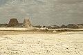 Distant view


References
- ^ Peust, Carsten (2010). Die Toponyme vorarabischen Ursprungs im modernen Ägypten. Göttingen. p. 39.
{{cite book}}: CS1 maint: location missing publisher (link) - ^ a b c Gauthier, Henri (1929). Dictionnaire des Noms Géographiques Contenus dans les Textes Hiéroglyphiques Vol. 6. p. 4.
- ^ Wallis Budge, E. A. (1920). An Egyptian hieroglyphic dictionary: with an index of English words, king list and geological list with indexes, list of hieroglyphic characters, coptic and semitic alphabets, etc. Vol II. John Murray. p. 1050.
- ISBN 978-88-7814-520-7.
- ^ "Sights in Qasr Al Farafra."". Archived from the original on 2013-10-03. Retrieved 2013-06-13.
- ^ ""Water Wells of Farafra."". Archived from the original on 2013-06-18. Retrieved 2013-06-13.
- ^ "Farafra Climate Normals 1961–1990". National Oceanic and Atmospheric Administration. Retrieved October 25, 2015.
- ^ "Farafra, Egypt: Climate, Global Warming, and Daylight Charts and Data". Climate Charts. Archived from the original on 17 August 2013. Retrieved 17 July 2013.
Bibliography
- Frank Bliss: 'Oasenleben. Die ägyptischen Oasen Bahriya und Farafra in Vergangenheit und Gegenwart'. Die ägyptischen Oasen Band 2. Bonn 2006.
- Frank Bliss: 'Artisanat et artisanat d’art dans les oasis du désert occidental égyptien'. "Veröffentlichungen des Frobenius-Instituts". Köln 1998.
- Beadnell, Hugh J. L. The Farafra Oasis: Its Topography and Geology. Geological Survey Report. Part 3 Egypt. Maṣlaḥat al-Misāḥah. 1901.
- Fakhry, Ahmed. 1974. Bahriyah and Farafra. Reissue of the Classic History and Description. Illustrated, reprint. Publisher: American Univ. in Cairo Press, 1974. ISBN 9774247329, 9789774247323. 189 pages.
External links
- (in German) Farafra oasis on Wikivoyage