
Feijenoord
Feijenoord | |
|---|---|
UTC+1 (CET) | |
| Website | https://www.rotterdam.nl/feijenoord |
Feijenoord (Dutch pronunciation:
The district gained significance in the 19th century as a centre of shipbuilding, principally at the Fijenoord yard.
Neighbourhoods in Feijenoord
Ethnicity
The majority of the population of Feijenoord are immigrants, approximately 36% of the population are Dutch natives, 8% are western immigrants and 56% are non-western immigrants. The biggest non-western immigrant groups are Moroccan (10%), Netherlands Antillean (4%), Surinamese (11%) and Turks (19%).[1]
Problematic neighbourhoods
According to a list made by Eberhard van der Laan (State Secretary of infrastructure), four out of the eight neighbourhoods in Feijenoord are amongst the most problematic neighbourhoods in the Netherlands.[2] The Bloemhof neighbourhood ranks at number 4 on the list, making it the most problematic neighbourhood in its district and the second in the south of Rotterdam, followed by Hillesluis at rank 13, Afrikaanderwijk at rank 33 and Vreewijk at rank 44.[3]
Poverty
Around 29% of the total population of Feijenoord lives on welfare, while the average for Rotterdam is 21%.[4] Bloemhof and Hillesluis neighbourhoods have an unemployment rate above 40%,[5] which is higher than the average for Rotterdam (13%) and the Netherlands (6%). 63% of the population of Feijenoord has a low level of educational attainment, compared to the Rotterdam average of 49%.[6]
Images
-
 Putsebocht in Bloemhof
 -
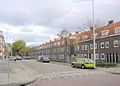
 Beijerlandselaan in Hillesluis
 -
 Latter-day Saint chapel in Vreewijk
 -
 Protestant school in Afrikaanderwijk (1909)
 -
 Lange Hilleweg in Bloemhof
 -
 Pest house in Feijenoord neighbourhood (1804)
 -
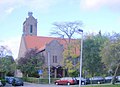 Orthodox church in Vreewijk


References
- ^ "Archived copy". Archived from the original on 2017-08-18. Retrieved 2017-08-17.
{{cite web}}: CS1 maint: archived copy as title (link) - ^ "Van der Laan maakt hele lijst probleemwijken bekend". 26 February 2009.
- ^ "Van der Laan maakt hele lijst probleemwijken bekend". 26 February 2009.
- ^ "Archived copy". Archived from the original on 2017-08-18. Retrieved 2017-08-17.
{{cite web}}: CS1 maint: archived copy as title (link) - ^ "10.000 huishoudens Feijenoord onder armoedegrens". 22 March 2011.
- ^ "Archived copy". Archived from the original on 2017-08-18. Retrieved 2017-08-17.
{{cite web}}: CS1 maint: archived copy as title (link)
External links
Boroughs of Rotterdam | ||
|---|---|---|
| International | |
|---|---|
| National | |
51°53′46″N 4°30′50″E / 51.896°N 4.514°E
This South Holland location article is a stub. You can help Wikipedia by expanding it. |