
Ferry Reach, Bermuda
Ferry Reach is a three mile (five kilometre) long channel in the north-east of Bermuda, which lies between St. George's Island in the north and St. David's Island in the south south-west of the town of St. George's.
It extends south from St. George's Harbour, Bermuda, linking it with Castle Harbour, and is crossed by two bridges at its northern end.
The name also applies to the western end of St. George's Island which lies to the north of this channel, and, more loosely, to the water passage between the western tip (Ferry Point) of this and Coney Island. Three forts had been sited on Ferry point, the most recent being the
The land area contains two British military
Most of the area is, today, a public parkland, but is still used frequently for military training by the
Gallery
-
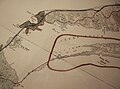 Map of Ferry Reach before the area to its south was radically altered in 1941 by the construction of an airfield.
 -
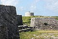 Two of the three forts at Ferry Reach, Ferry Island Fort (in the foreground), and the Martello tower in the background, in 2011. Burnt Point Fort (or Ferry Point Battery), built in 1688, is out of sight, to the left (West).
 -
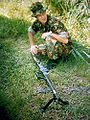 AWarrant Officer, training at Ferry Reach.
 -
 Royal Bermuda Regiment soldier with a Ruger Mini-14 at Ferry Reach in 1994
 -
 Ferry Reach, looking over the North Shore. Lovers' Lake is visible at the left.
 -
 Looking across Ferry Reach towards St. David's. The house in the foreground was originally the home ofglideslopeof the main runway passing directly over his roof.


References
- ^ "The Bermuda National Trust". Archived from the original on 2007-12-02. Retrieved 2006-05-26.