
File:1794 Anville Map of Ancient Egypt - Geographicus - Egypt-anville-1794.jpg

Size of this preview: 400 × 600 pixels. Other resolutions: 160 × 240 pixels | 320 × 480 pixels | 512 × 768 pixels | 683 × 1,024 pixels | 1,366 × 2,048 pixels | 2,668 × 4,000 pixels.
Original file (2,668 × 4,000 pixels, file size: 2.64 MB, MIME type: image/jpeg)
| This is a file from the Wikimedia Commons. Information from its description page there is shown below. Commons is a freely licensed media file repository. You can help. |
| Jean Baptiste Bourguignon d'Anville: Aegyptus Antiqua Mandato Serenissimi Delphini Publici Juris Facta.
( |
|||||||||||||||||||||
|---|---|---|---|---|---|---|---|---|---|---|---|---|---|---|---|---|---|---|---|---|---|
| Artist |
|
||||||||||||||||||||
| Title |
Aegyptus Antiqua Mandato Serenissimi Delphini Publici Juris Facta. |
||||||||||||||||||||
| Description |
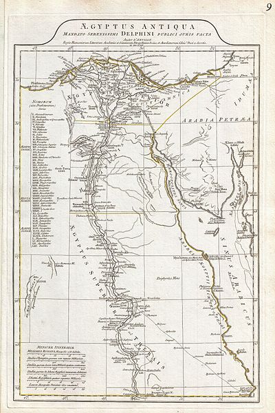
English: A large and dramatic 1794 J. B. B. D'Anville map of Ancient Egypt Covers from the Nile Delta and Gaza south as far as Aswan. Details mountains, rivers, cities, roadways, and lakes with political divisions highlighted in outline color. Features both ancient and contemporary place names, ie. Thebae and Luxor, for each destination - an invaluable resource or scholars of antiquity. Identifies the Pyramids, Mount Sinai, Natron, Philae Island, the Cataracts, etc. Title area appears in a raised zone above the map proper. Includes six distance scales, bottom left, referencing various measurement systems common in antiquity. Text in Latin and English. Drawn by J. B. B. D'Anville in 1762 and published in 1794 by Laurie and Whittle, London. |
||||||||||||||||||||
| Date | 1794 (dated) | ||||||||||||||||||||
| Dimensions | height: 20 in (50.8 cm); width: 12.5 in (31.7 cm) | ||||||||||||||||||||
| Accession number |
Geographicus link: Egypt-anville-1794 |
||||||||||||||||||||
| Source/Photographer |
D'Anville, J. B. B., Complete Body of Ancient Geography, Laurie and Whittle, London, 1795.
|
||||||||||||||||||||
| Permission (Reusing this file) |
|
||||||||||||||||||||

File history
Click on a date/time to view the file as it appeared at that time.
| Date/Time | Thumbnail | Dimensions | User | Comment | |
|---|---|---|---|---|---|
| current | 14:49, 23 March 2011 | | 2,668 × 4,000 (2.64 MB) | BotMultichillT | {{subst:User:Multichill/Geographicus |link=http://www.geographicus.com/P/AntiqueMap/Egypt-anville-1794 |product_name=1794 Anville Map of Ancient Egypt |map_title=Aegyptus Antiqua Mandato Serenissimi Delphini Publici Juris Facta. |description=A large and d |
File usage
The following pages on the English Wikipedia use this file (pages on other projects are not listed):
Global file usage
The following other wikis use this file:
- Usage on bn.wikipedia.org
- Usage on id.wikipedia.org
- Usage on io.wikipedia.org
- Usage on ms.wikipedia.org
- Usage on ru.wikipedia.org
- Usage on sk.wikipedia.org
- Usage on ta.wikipedia.org
- Usage on xmf.wikipedia.org