
File:1946 Huntington Planning Map.png
Original file (3,200 × 4,395 pixels, file size: 7.16 MB, MIME type: image/png)
| This is a file from the Wikimedia Commons. Information from its description page there is shown below. Commons is a freely licensed media file repository. You can help. |
Summary
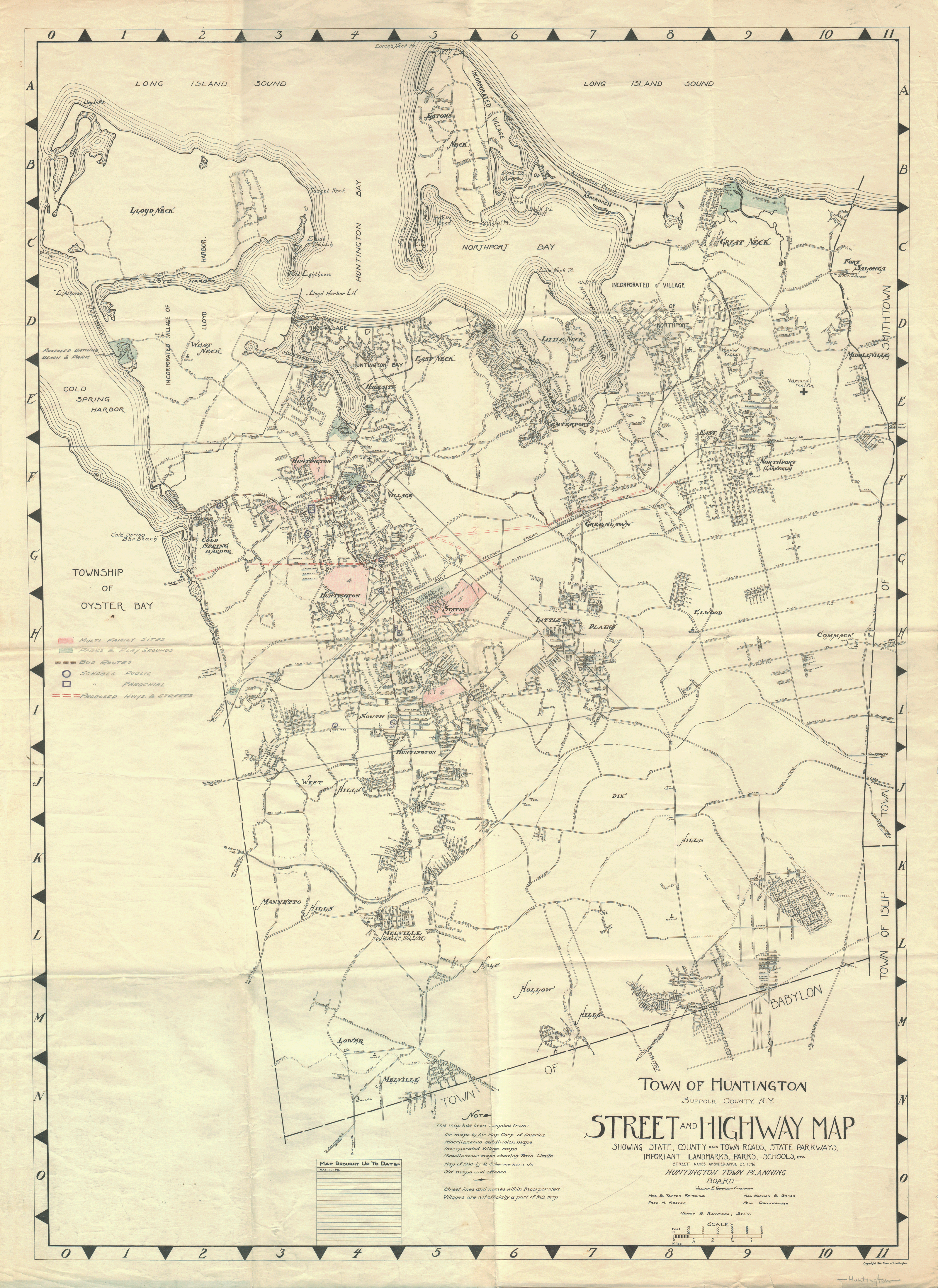
This is a digital image of a 1946 Town of Huntington, New York Planning Map.
Backstory
In the early 1980's, a department of the New York State Department of Housing and Urban Development (NYS-HUD) was relocating to a new office location. Workers were told to throw thousands of documents in the trash rather than move them to the new office location. This map was saved from those NYS-HUD archives.
Licensing
It was copyrighted in 1946 by the town of Huntington. The copyright was not renewed ([1] archive copy at the Wayback Machine) and thus expired in 1974. I have received permission to share this map as Public Domain by officials of the Town of Huntington.
This work is in the public domain because it was published in the United States between 1929 and 1963, and although there may or may not have been a copyright notice, the copyright was not renewed. For further explanation, see Commons:Hirtle chart and the copyright renewal logs. Note that it may still be copyrighted in jurisdictions that do not apply the rule of the shorter term for US works (depending on the date of the author's death), such as Canada (70 years p.m.a.), Mainland China (50 years p.m.a., not Hong Kong or Macao), Germany (70 years p.m.a.), Mexico (100 years p.m.a.), Switzerland (70 years p.m.a.), and other countries with individual treaties.
|
 |
File Details
This is the largest complete version of this map uploaded to Wikimedia. An even larger .png file exists with more detail (109 megs and over 56 million pixels) but it greatly exceeded Wikimedia's file size and dimension restrictions. Smaller sections of this map may also be uploaded to allow "zoom-in" functionality to a Wikipedia article.
File history
Click on a date/time to view the file as it appeared at that time.
| Date/Time | Thumbnail | Dimensions | User | Comment | |
|---|---|---|---|---|---|
| current | 19:29, 26 April 2006 | | 3,200 × 4,395 (7.16 MB) | Fife Club | This is a digital image of a 1946 Town of Huntington Planning Map. == Backstory == In the early 1980's, a department of the New York State Department of Housing and Urban Development (NYS-HUD) was relocating to a new office loc |