
File:2008 Presidential Election by County.svg

Size of this PNG preview of this SVG file: 555 × 352 pixels. Other resolutions: 320 × 203 pixels | 640 × 406 pixels | 1,024 × 649 pixels | 1,280 × 812 pixels | 2,560 × 1,624 pixels.
Original file (SVG file, nominally 555 × 352 pixels, file size: 1.45 MB)
| This is a file from the Wikimedia Commons. Information from its description page there is shown below. Commons is a freely licensed media file repository. You can help. |
Summary
| Description |
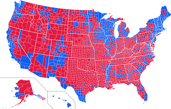
English: November 2008 U.S. Presidential Election map, winner county by county
Red = McCain, Blue = Obama |
| Date | |
| Source | Derived from Image:USA Counties.svg, but color data entirely original. |
| Author | Robert Horning |
Data Sources
- http://elect.alaska.net/ (Alaska) @@@
- http://www.azsos.gov/results/2008/general/GEN-100.htm archive copy at the Wayback Machine (Arizona)
- http://vote.sos.ca.gov/Returns/pres/all.htm archive copy at the Wayback Machine (California)
- http://www.elections.colorado.gov/DDefault.aspx?tid=984 (Colorado) @@
- http://hawaii.gov/elections/results/2008/general/ (Hawaii)
- http://www.sos.idaho.gov/ELECT/results/ENR/candidate_county_grid.html (Idaho)
- http://www.kssos.org/ent/maps_graphs.html#PRESDT (Kansas)
- http://sos.mt.gov/ELB/Results.asp archive copy at the Wayback Machine (Montana) @@
- http://www.silverstate08.com/ (Nevada)
- http://www.sos.state.nm.us/sos-elections.html archive copy at the Wayback Machine (New Mexico) @@
- http://www.elections.state.ok.us/index.html (Oklahoma) @
- http://records.sos.state.or.us/ORSOSWebDrawer/Recordpdf/6873598 (Oregon)
- http://team1.sos.state.tx.us/enr/results/nov04_141_race0.htm[dead link] (Texas)
- http://electionresults.utah.gov/xmlData/30001.html archive copy at the Wayback Machine (Utah)
- http://vote.wa.gov/elections/wei/Results.aspx?RaceTypeCode=O&JurisdictionTypeID=1&ElectionID=26&ViewMode=Results (Washington)
- http://soswy.state.wy.us/Elections/08Results/General/SW-Candidates.pdf archive copy at the Wayback Machine (Wyoming)
- (@) No data for individual counties
- (@@) Data for state unavailable
- (@@@) Data for legislative districts only, not by county bourgough
Licensing
I, the copyright holder of this work, hereby publish it under the following licenses:
This file is licensed under the Creative Commons Attribution-Share Alike 3.0 Unported license.
- You are free:
- to share – to copy, distribute and transmit the work
- to remix – to adapt the work
- Under the following conditions:
- attribution – You must give appropriate credit, provide a link to the license, and indicate if changes were made. You may do so in any reasonable manner, but not in any way that suggests the licensor endorses you or your use.
- share alike – If you remix, transform, or build upon the material, you must distribute your contributions under the same or compatible license as the original.

|
Permission is granted to copy, distribute and/or modify this document under the terms of the GNU Free Documentation License, Version 1.2 or any later version published by the Free Software Foundation; with no Invariant Sections, no Front-Cover Texts, and no Back-Cover Texts. A copy of the license is included in the section entitled GNU Free Documentation License. |
You may select the license of your choice.
File history
Click on a date/time to view the file as it appeared at that time.
| Date/Time | Thumbnail | Dimensions | User | Comment | |
|---|---|---|---|---|---|
| current | 22:55, 1 February 2013 | | 555 × 352 (1.45 MB) | EmmaCoop | I revised the coloring and updated two counties. |
| 09:13, 30 November 2008 |  | 555 × 352 (1.38 MB) | Mr. Matté | Completing the map | |
| 18:14, 5 November 2008 |  | 555 × 352 (2.04 MB) | Robert Horning | ||
| 17:10, 5 November 2008 |  | 555 × 352 (2.04 MB) | Robert Horning | {{Information |Description={{en|1=November 2008 U.S. Presidential Election map, winner county by county Red = McCain, Blue = Obama}} |Source=Derived from Image:USA Counties.svg, but color data entirely original. |Author=[[User:Robert Horning|Robert |
File usage
No pages on the English Wikipedia use this file (pages on other projects are not listed).
Global file usage
The following other wikis use this file:
- Usage on sk.wikipedia.org