
File:2014 Russo-ukrainian-conflict map.svg

Size of this PNG preview of this SVG file: 552 × 599 pixels. Other resolutions: 221 × 240 pixels | 442 × 480 pixels | 707 × 768 pixels | 943 × 1,024 pixels | 1,886 × 2,048 pixels | 4,126 × 4,480 pixels.
Original file (SVG file, nominally 4,126 × 4,480 pixels, file size: 2.75 MB)
| This is a file from the Wikimedia Commons. Information from its description page there is shown below. Commons is a freely licensed media file repository. You can help. |
Summary
| Description |
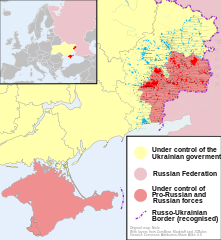
English: Map of the '2014 Russo-Ukrainian War', '2014 Ukraine' or '2014 Russian military intervention in Ukraine '.
(Includes '2014 Crimean Crisis' and 'War in Donbass') |
| Date | |
| Source | Own work |
| Author | Niele |
| Other versions |
[]
|
| SVG development |


.png)


Licensing
I, the copyright holder of this work, hereby publish it under the following license:
This file is licensed under the Creative Commons Attribution-Share Alike 4.0 International license.
- You are free:
- to share – to copy, distribute and transmit the work
- to remix – to adapt the work
- Under the following conditions:
- attribution – You must give appropriate credit, provide a link to the license, and indicate if changes were made. You may do so in any reasonable manner, but not in any way that suggests the licensor endorses you or your use.
- share alike – If you remix, transform, or build upon the material, you must distribute your contributions under the same or compatible license as the original.
File history
Click on a date/time to view the file as it appeared at that time.
| Date/Time | Thumbnail | Dimensions | User | Comment | |
|---|---|---|---|---|---|
| current | 16:03, 9 October 2014 | | 4,126 × 4,480 (2.75 MB) | Mondolkiri1 | Marinka and Novotroitske - http://militarymaps.info/ |
| 03:27, 9 October 2014 |  | 4,126 × 4,480 (2.75 MB) | Mondolkiri1 | Update according to http://militarymaps.info/ and other sources provided in File:East Ukraine Conflict.svg | |
| 23:30, 6 October 2014 |  | 4,126 × 4,480 (2.74 MB) | Mondolkiri1 | Corrected Zolote and added Novoslapa | |
| 23:20, 6 October 2014 |  | 4,126 × 4,480 (2.74 MB) | Mondolkiri1 | Update according to http://militarymaps.info/ , http://www.segodnya.ua/regions/donetsk/moskal-boeviki-obyavili-na-menya-ohotu-558223.html and other sources in my talk page | |
| 07:13, 5 October 2014 |  | 4,126 × 4,480 (2.74 MB) | Mondolkiri1 | Update Donbass according to File:East Ukraine Conflict.svg | |
| 17:50, 19 September 2014 |  | 4,126 × 4,480 (2.73 MB) | Hanibal911 | POV Vandalism I revert all unjustified changes which was made based unreliable sources | |
| 07:46, 19 September 2014 |  | 4,126 × 4,480 (2.71 MB) | Niele~commonswiki | - Added Lutuhyne tot the red area as suggested by user Mondolkiri1 - Updated legenda and unclear/conflicting report-colours. This was a constructive way to prevent discussions, edit warring on basis of conflicting sources | |
| 13:26, 18 September 2014 |  | 4,126 × 4,480 (2.73 MB) | Hanibal911 | POV Pushing we not use this not correct maps which contradicts to many sources | |
| 13:01, 18 September 2014 |  | 4,126 × 4,480 (2.7 MB) | Niele~commonswiki | Not true, http://mediarnbo.org/ is the official communication-website of Ukrainean Forces, while http://liveuamap.com is unofficial map hosted from the us.Reverted to version as of 12:40, 18 September 2014 | |
| 12:44, 18 September 2014 |  | 4,126 × 4,480 (2.73 MB) | Mondolkiri1 | Reverted to version as of 12:32, 18 September 2014 Sorry, but the http://liveuamap.com/ is the official Ukrainian ATO site, and as I said, Lutuhyne is in the pink area there, not in the foggy zone! |
File usage
The following pages on the English Wikipedia use this file (pages on other projects are not listed):
Global file usage
The following other wikis use this file:
- Usage on af.wikipedia.org
- Usage on bn.wikipedia.org
- Usage on cs.wikipedia.org
- Usage on de.wikipedia.org
- Usage on fi.wikipedia.org
- Usage on he.wikipedia.org
- Usage on incubator.wikimedia.org
- Usage on it.wikiquote.org
- Usage on ja.wikipedia.org
- Usage on ka.wikipedia.org
- Usage on lv.wikipedia.org
- Usage on mk.wikipedia.org
- Usage on ne.wikipedia.org
- Usage on nl.wikipedia.org
- Usage on pt.wikipedia.org
- Usage on ru.wikinews.org
- Usage on ru.wikiquote.org
- Usage on sd.wikipedia.org
- Usage on te.wikipedia.org
- Usage on uk.wikipedia.org
- Usage on uk.wikiquote.org
- Usage on vi.wikipedia.org