
File:2016 GOP Primary Counties.svg

Size of this PNG preview of this SVG file: 800 × 470 pixels. Other resolutions: 320 × 188 pixels | 640 × 376 pixels | 1,024 × 602 pixels | 1,280 × 752 pixels | 2,560 × 1,505 pixels | 968 × 569 pixels.
Original file (SVG file, nominally 968 × 569 pixels, file size: 13.33 MB)
| This is a file from the Wikimedia Commons. Information from its description page there is shown below. Commons is a freely licensed media file repository. You can help. |
Summary
| Description |
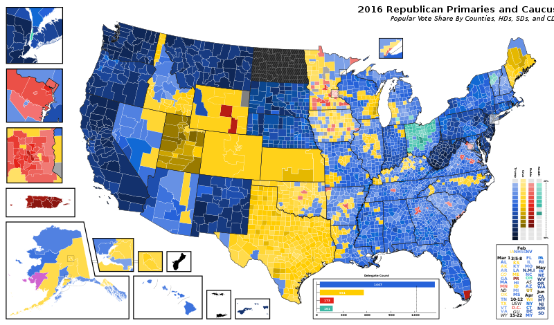
English: 2016 GOP Presidential Primary Primary Subdivision (County, State Senate Districts, State House Districts) Map . Counties and States shapefile from NHGIS, results data from New York Times. MapShaper, QGIS, Inkscape used to make map. |
| Date | |
| Source | Own work |
| Author |
User:MisterElection2001 |
Licensing
I, the copyright holder of this work, hereby publish it under the following license:
This file is licensed under the Creative Commons Attribution-Share Alike 4.0 International license.
- You are free:
- to share – to copy, distribute and transmit the work
- to remix – to adapt the work
- Under the following conditions:
- attribution – You must give appropriate credit, provide a link to the license, and indicate if changes were made. You may do so in any reasonable manner, but not in any way that suggests the licensor endorses you or your use.
- share alike – If you remix, transform, or build upon the material, you must distribute your contributions under the same or compatible license as the original.
File history
Click on a date/time to view the file as it appeared at that time.
| Date/Time | Thumbnail | Dimensions | User | Comment | |
|---|---|---|---|---|---|
| current | 01:42, 3 March 2023 | | 968 × 569 (13.33 MB) | Talleyrand6 | Uploaded own work with UploadWizard |
File usage
The following pages on the English Wikipedia use this file (pages on other projects are not listed):