
File:2020 United States presidential election in Oklahoma results map by state house district.svg

Size of this PNG preview of this SVG file: 800 × 407 pixels. Other resolutions: 320 × 163 pixels | 640 × 325 pixels | 1,024 × 520 pixels | 1,280 × 650 pixels | 2,560 × 1,301 pixels | 3,784 × 1,923 pixels.
Original file (SVG file, nominally 3,784 × 1,923 pixels, file size: 3.98 MB)
| This is a file from the Wikimedia Commons. Information from its description page there is shown below. Commons is a freely licensed media file repository. You can help. |
Summary
| Description |
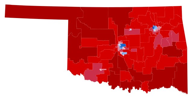
English: Results of the 2020 United States presidential election in Oklahoma. Data from the Oklahoma State Election Board. Precinct shapefile from the University of Oklahoma Center for Spatial Analysis. Early and absentee votes in Oklahoma County and Tulsa County were formulaically allocated to the precinct level based on election day results. Precinct results were aggregated to acquire state house district results. |
| Date | |
| Source | Own work |
| Author | Master of Time |
Licensing
I, the copyright holder of this work, hereby publish it under the following license:
This file is licensed under the Creative Commons Attribution-Share Alike 4.0 International license.
- You are free:
- to share – to copy, distribute and transmit the work
- to remix – to adapt the work
- Under the following conditions:
- attribution – You must give appropriate credit, provide a link to the license, and indicate if changes were made. You may do so in any reasonable manner, but not in any way that suggests the licensor endorses you or your use.
- share alike – If you remix, transform, or build upon the material, you must distribute your contributions under the same or compatible license as the original.
File history
Click on a date/time to view the file as it appeared at that time.
| Date/Time | Thumbnail | Dimensions | User | Comment | |
|---|---|---|---|---|---|
| current | 00:44, 17 October 2022 | | 3,784 × 1,923 (3.98 MB) | Master of Time | {{Information |description={{en|1=Results of the 2020 United States presidential election in Oklahoma. [https://results.okelections.us/OKER/?elecDate=20201103 Data from the Oklahoma State Election Board]. Precinct shapefile from the University of Oklahoma Center for Spatial Analysis. Early and absentee votes in Oklahoma County and Tulsa County were formulaically allocated to the precinct level based on election day results. Precinct r... |
File usage
No pages on the English Wikipedia use this file (pages on other projects are not listed).