
File:950Pedro Orata, Urdaneta, Pangasinan 50.png
No higher resolution available.
950Pedro_Orata,_Urdaneta,_Pangasinan_50.png (280 × 289 pixels, file size: 65 KB, MIME type: image/png)
| This is a file from the Wikimedia Commons. Information from its description page there is shown below. Commons is a freely licensed media file repository. You can help. |
Summary
| Description |
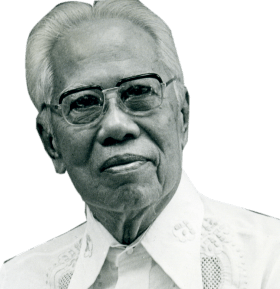
English: Our Lady of Lourdes Parish Church of Bactad, Urdaneta Roman Catholic Diocese of Urdaneta along Urdaneta-Asingan-Tayug Road (San Vicente - Bactad East, Urdaneta City) Urdaneta-Asingan-Tayug Road from Urdaneta-Manaoag Road-San Vicente along San Vicente Central-East-West Crossing, Urdaneta City San Vicente West, Urdaneta City to Urdaneta Junction-Dagupan-Lingayen Road (Poblacion-Catablan, Urdaneta) Category:Sitios and puroks of the Philippines Subdivisions of the Philippines List of barangays in Pangasinan, Barangays of Pangasinan, Pangasinan Province, Barangays Pedro T. Orata, Urdaneta, Pangasinan 15.9817, 120.6131 Bactad East, Urdaneta, Pangasinan 15.9857, 120.6254 Urdaneta, Pangasinan, Pangasinan Province Pedro Tamesis Orata "Father of Barangay High Schools" from or along MacArthur Highway or Manila North Road MacArthur Highway (Urdaneta, Pangasinan) Philippine highway network (Note: Judge Florentino Floro, the owner, to repeat, Donor Florentino Floro of all these photos hereby donate gratuitously, freely and unconditionally Judge Floro all these photos to and for Wikimedia Commons, exclusively, for public use of the public domain, and again without any condition whatsoever). |
| Date | |
| Source | Own work Taken from Google images, which I think is free image for Pedro died long ago |
| Author | Judgefloro |
| Camera location | | View this and other nearby images on: OpenStreetMap |
|---|
Pedro T. Orata, Urdaneta, Pangasinan 15.9817, 120.6131
Licensing
I, the copyright holder of this work, hereby publish it under the following license:
| This file is made available under the Creative Commons CC0 1.0 Universal Public Domain Dedication. | |
| The person who associated a work with this deed has dedicated the work to the public domain by waiving all of their rights to the work worldwide under copyright law, including all related and neighboring rights, to the extent allowed by law. You can copy, modify, distribute and perform the work, even for commercial purposes, all without asking permission.
|
File history
Click on a date/time to view the file as it appeared at that time.
| Date/Time | Thumbnail | Dimensions | User | Comment | |
|---|---|---|---|---|---|
| current | 07:10, 12 October 2019 | | 280 × 289 (65 KB) | Judgefloro | User created page with UploadWizard |
File usage
The following pages on the English Wikipedia use this file (pages on other projects are not listed):