
File:Afghanistan 1860.png
Size of this preview: 607 × 599 pixels. Other resolutions: 243 × 240 pixels | 486 × 480 pixels | 778 × 768 pixels | 1,037 × 1,024 pixels | 1,673 × 1,652 pixels.
Original file (1,673 × 1,652 pixels, file size: 206 KB, MIME type: image/png)
| This is a file from the Wikimedia Commons. Information from its description page there is shown below. Commons is a freely licensed media file repository. You can help. |
Summary
| Description |
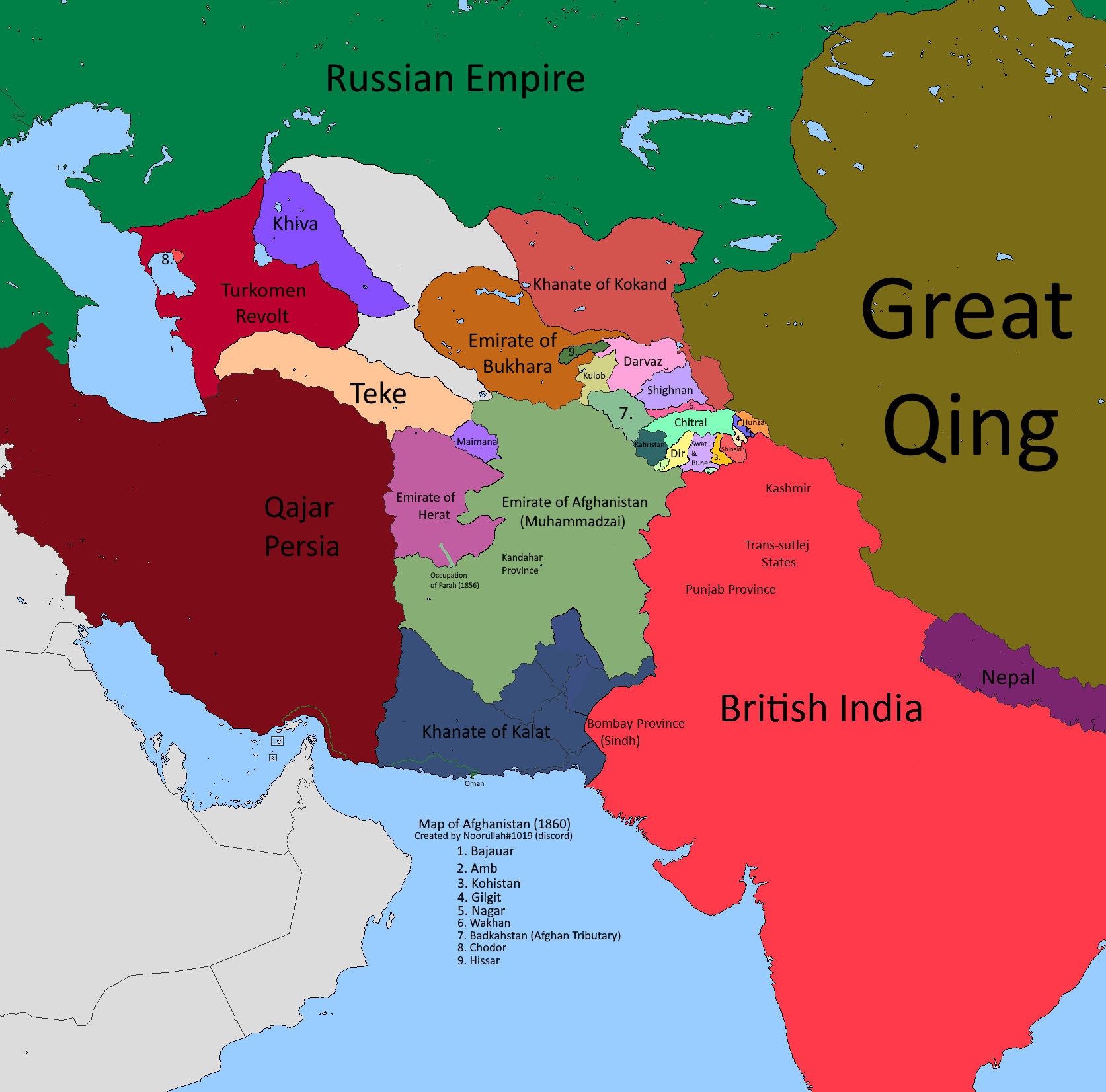
English: map of afghanistan and surroundings in the year 1860 |
| Date | |
| Source | Own work |
| Author | Noorullah21 |
Licensing
I, the copyright holder of this work, hereby publish it under the following license:
This file is licensed under the Creative Commons Attribution-Share Alike 4.0 International license.
- You are free:
- to share – to copy, distribute and transmit the work
- to remix – to adapt the work
- Under the following conditions:
- attribution – You must give appropriate credit, provide a link to the license, and indicate if changes were made. You may do so in any reasonable manner, but not in any way that suggests the licensor endorses you or your use.
- share alike – If you remix, transform, or build upon the material, you must distribute your contributions under the same or compatible license as the original.
File history
Click on a date/time to view the file as it appeared at that time.
| Date/Time | Thumbnail | Dimensions | User | Comment | |
|---|---|---|---|---|---|
| current | 01:08, 2 March 2022 | | 1,673 × 1,652 (206 KB) | Noorullah21 | added credits and a possible info of contact if needed |
| 02:10, 20 January 2022 |  | 1,673 × 1,652 (172 KB) | Noorullah21 | fixed kokand-qing-russian border..........again | |
| 04:05, 19 January 2022 |  | 1,673 × 1,652 (169 KB) | Noorullah21 | fixed russian-qing border | |
| 02:17, 17 January 2022 |  | 1,673 × 1,652 (170 KB) | Noorullah21 | THE FINAL FINISH TO CENTRAL ASIA! Bukhara, kokand hissar added, russian borders with qing fixed, khiva fixed, turkomen revolt fixed. | |
| 06:36, 7 January 2022 |  | 1,673 × 1,652 (162 KB) | Noorullah21 | Added russia, khiva, turkomen revolt/civil war for old khiva, and some other small nations and changes to maimana border, etc. | |
| 20:00, 13 December 2021 |  | 1,673 × 1,652 (158 KB) | Weaveravel | further minor crop to centerize with taking present borders into consideration | |
| 04:02, 13 December 2021 |  | 1,717 × 1,652 (161 KB) | Noorullah21 | fixes to shighnan border, roshan was a province of them | |
| 01:21, 11 December 2021 |  | 1,717 × 1,652 (156 KB) | Weaveravel | cropped to centerize Afg | |
| 21:44, 4 December 2021 |  | 1,865 × 1,725 (153 KB) | Noorullah21 | Big changes to map, made herat, kalat, british borders more accurate with afghanistan. and fixes to sindh border with kalat | |
| 03:08, 30 November 2021 |  | 1,865 × 1,725 (148 KB) | Noorullah21 | Fixed darvaz and shighnan region to be more accurate, specifically fixed afghan, shignan, darvaz, and roshan borders. |
File usage
The following pages on the English Wikipedia use this file (pages on other projects are not listed):
Global file usage
The following other wikis use this file:
- Usage on bn.wikipedia.org
- Usage on fa.wikipedia.org
- Usage on hy.wikipedia.org
- Usage on id.wikipedia.org
- Usage on pnb.wikipedia.org
- Usage on ps.wikipedia.org
- Usage on ru.wikipedia.org
- Usage on uk.wikipedia.org
- Usage on ur.wikipedia.org