
File:ArmstrongMapHomildon1769.JPG
No higher resolution available.
ArmstrongMapHomildon1769.JPG (476 × 399 pixels, file size: 47 KB, MIME type: image/jpeg)
| This is a file from the Wikimedia Commons. Information from its description page there is shown below. Commons is a freely licensed media file repository. You can help. |
Summary
| Description |
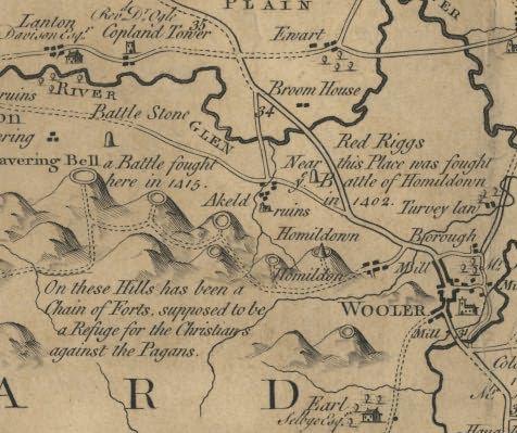
English: A detail from Armstrong's map of Northumberland (1769) showing Homildon Hill near Wooler |
| Date | |
| Source | Transferred from en.wikipedia to Commons. |
| Author | Lieutenant Andrew Armstrong & Sons |
Licensing
|
This work is in the public domain in its country of origin and other countries and areas where the copyright term is the author's life plus 100 years or fewer. | |
| This file has been identified as being free of known restrictions under copyright law, including all related and neighboring rights. | |
Original upload log
The original description page was here. All following user names refer to en.wikipedia.
| Date/Time | Dimensions | User | Comment |
|---|---|---|---|
| 2005-06-13 14:03 | 476×399× (48510 bytes) | Nesbit | A detail from Armstrongs map of Northumberland (1769) showing Homildon Hill near Wooler {{PD-old}} |
File history
Click on a date/time to view the file as it appeared at that time.
| Date/Time | Thumbnail | Dimensions | User | Comment | |
|---|---|---|---|---|---|
| current | 08:42, 4 October 2015 | | 476 × 399 (47 KB) | Andreas Werle | Transferred from en.wikipedia |
File usage
The following pages on the English Wikipedia use this file (pages on other projects are not listed):
Global file usage
The following other wikis use this file:
- Usage on de.wikipedia.org
- Usage on el.wikipedia.org
- Usage on uk.wikipedia.org
- Usage on www.wikidata.org