
File:Around Manchester railway map 1921.svg

Size of this PNG preview of this SVG file: 800 × 564 pixels. Other resolutions: 320 × 226 pixels | 640 × 451 pixels | 1,024 × 722 pixels | 1,280 × 903 pixels | 2,560 × 1,806 pixels | 1,398 × 986 pixels.
Original file (SVG file, nominally 1,398 × 986 pixels, file size: 279 KB)
| This is a file from the Wikimedia Commons. Information from its description page there is shown below. Commons is a freely licensed media file repository. You can help. |
Summary
| Description |
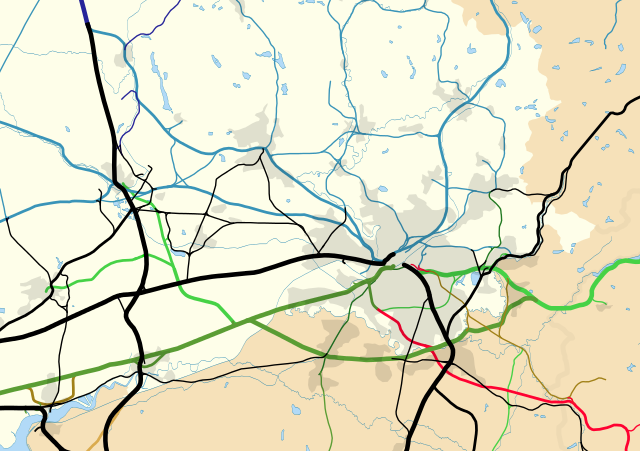
English: Map of the railways around Manchester, England, in 1921.
Equirectangular map projection on WGS 84 datum Geographic limits:
This limits are identical to File:Greater Manchester UK location map 2.svg and File:Greater Manchester railway map 2014.svg.
London and North Western (LNWR)
Lancashire and Yorkshire (LYR)
Midland (MR)
Great Central (GCR)
Cheshire Lines Committee (GCR / MR / GNR)
GCR / LNWR
GCR / MR
LYR / LNWR
GWR / LNWR
Other |
| Date | |
| Source |
This file was derived from: Greater Manchester UK location map 2.svg: |
| Author |
|
Licensing
This file is licensed under the Creative Commons Attribution-Share Alike 4.0 International license.
Attribution: Dr Greg and Nilfanion. Contains Ordnance Survey data © Crown copyright and database right 2010
- You are free:
- to share – to copy, distribute and transmit the work
- to remix – to adapt the work
- Under the following conditions:
- attribution – You must give appropriate credit, provide a link to the license, and indicate if changes were made. You may do so in any reasonable manner, but not in any way that suggests the licensor endorses you or your use.
- share alike – If you remix, transform, or build upon the material, you must distribute your contributions under the same or compatible license as the original.
References
- (1929) Combined index shewing parishes and the Ordnance Survey of Lancashire archive copy at the Wayback Machine, Ordnance Survey, copy online at Lancashire County Council website accessed 22 July 2012
- Wignall, C.J. (1983), Complete British Railways Maps and Gazetteer from 1830–1981, Oxford Railway Publishing Company, Oxford, ISBN 0 86093 162 5
- (1947–1957) Ordnance Survey New Popular Edition maps, copy online at New Popular Edition Maps website, accessed 14 August 2012
- (1909) Railway Junction Diagram Hough Green, Widnes & Runcorn, Railway Clearing House, p.18
- (1912) Railway Junction Diagram Ashton, Ashton Moss, Crothorn, Droylsden, Guide Bridge, Hyde, Oldham & Stalybridge, Railway Clearing House, p.32
- (1910) Railway Junction Diagram Manchester, Railway Clearing House, p.47
- (1909) Railway Junction Diagram Altrincham, Broadheath & Timperley; Apethorne, Bredbury, Brinnington, Godley, Marple & Woodley, Railway Clearing House, p.73
- (1907) Railway Junction Diagram Boar's Head, Haigh, Hindley, Pemberton, Plank Lane, Strangeways & Wigan, Railway Clearing House, p.77
- (1908) Railway Junction Diagram Rainford, Railway Clearing House, p.92
- (1903) Railway Junction Diagram Adlington & Chorley, Railway Clearing House, p.103
- (1903) Railway Junction Diagram Glazebrook & Partington, Railway Clearing House, p.138
- (1901) Railway Junction Diagram Acton Grange, Walton & Warrington, Railway Clearing House, p.147
- (1905) Railway Junction Diagram Clifton (Molyneux) & Patricroft, Railway Clearing House, p.148
- (1903) Railway Junction Diagram Cheadle, Chorlton, Heaton Mersey & Northenden, Railway Clearing House, p.149
- (1904) Railway Junction Diagram New Mills, Railway Clearing House, p.10
- (1914) Railway Junction Diagram Frodsham & Helsby; Middlewood, Railway Clearing House, p.106
,_Hay,_Liskeard,_Patricroft_%26_Uttoxeter_RJD_148.jpg)
File history
Click on a date/time to view the file as it appeared at that time.
| Date/Time | Thumbnail | Dimensions | User | Comment | |
|---|---|---|---|---|---|
| current | 17:52, 12 April 2015 | | 1,398 × 986 (279 KB) | Dr Greg | User created page with UploadWizard |
File usage
The following pages on the English Wikipedia use this file (pages on other projects are not listed):