
File:Asia in 1345.svg

Size of this PNG preview of this SVG file: 788 × 600 pixels. Other resolutions: 316 × 240 pixels | 631 × 480 pixels | 1,009 × 768 pixels | 1,280 × 974 pixels | 2,560 × 1,948 pixels | 1,100 × 837 pixels.
Original file (SVG file, nominally 1,100 × 837 pixels, file size: 1.02 MB)
| This is a file from the Wikimedia Commons. Information from its description page there is shown below. Commons is a freely licensed media file repository. You can help. |
Summary
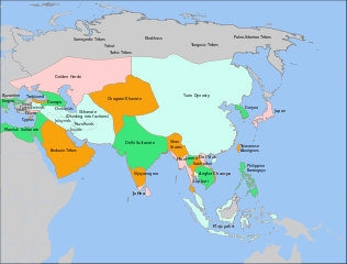
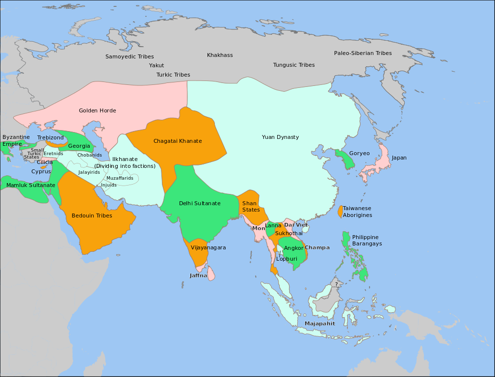
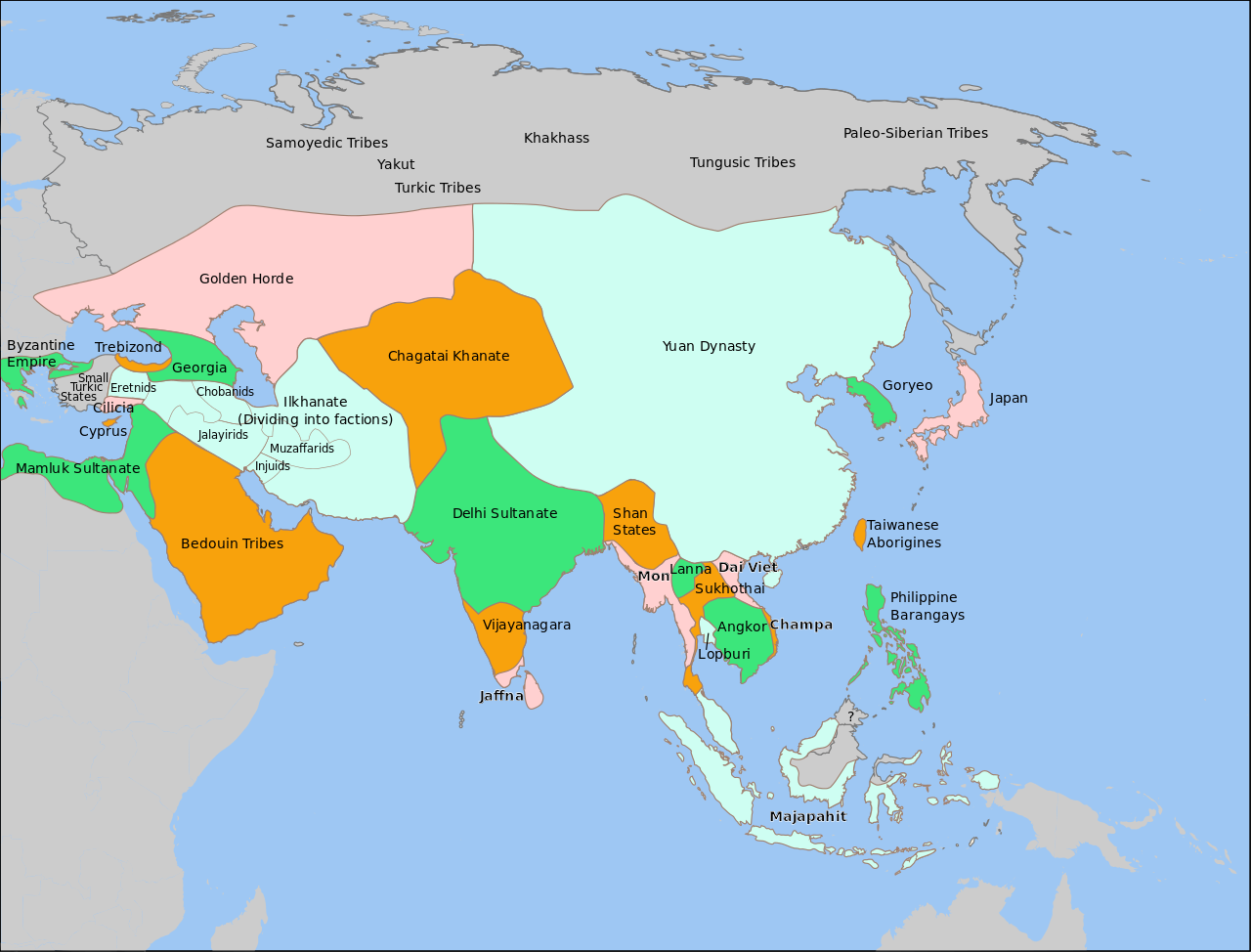
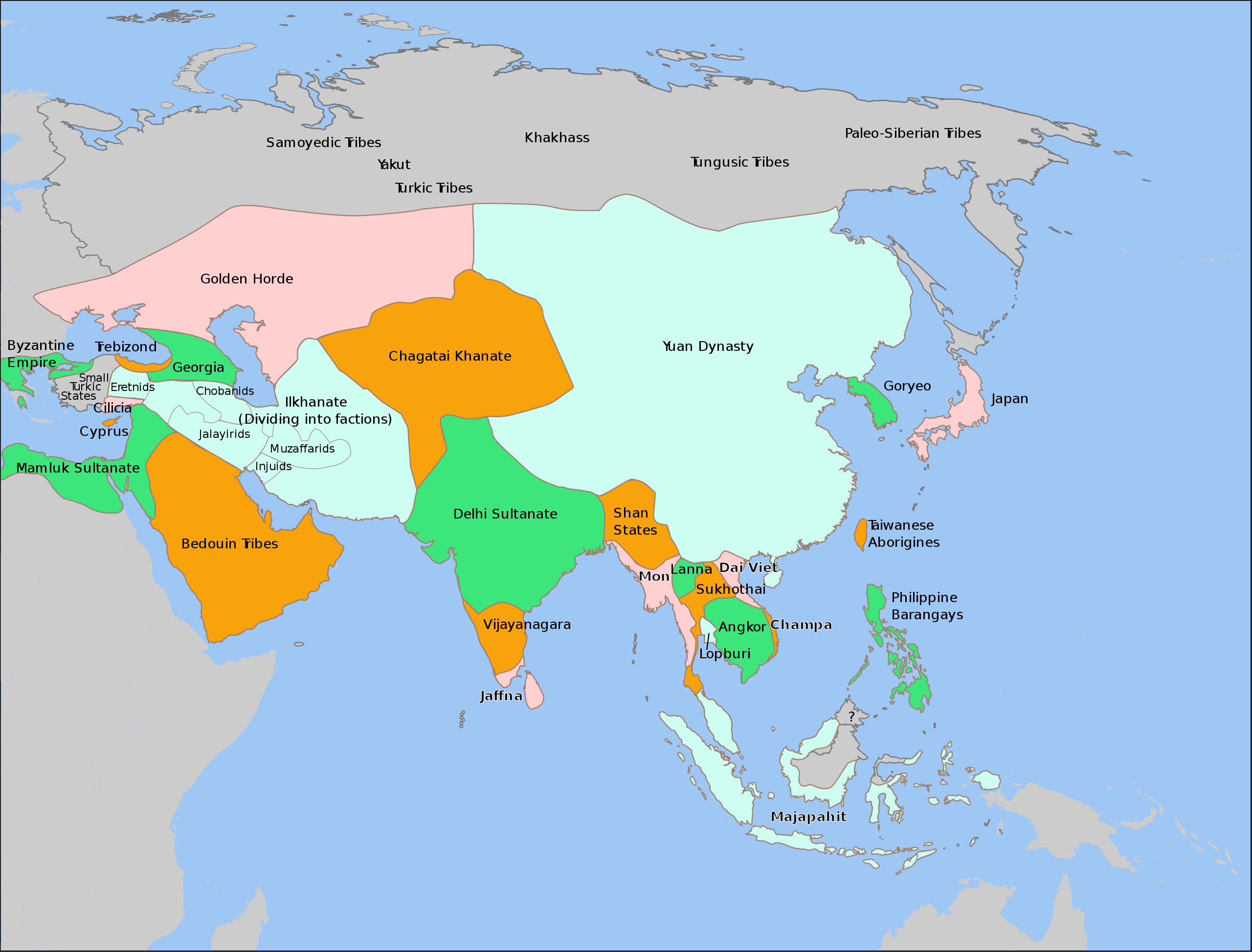
| Description | Aproximate outlines of nations in Asia in 1345. Please report any errors on the talk page, or on my talk page. |
| Date | |
| Source | various articles and maps on Wikipedia and the internet, including Image:PremongolEurasia.png, Image:Europe in 1345.png, Image:Mongol Empire map.gif, en:Image:Majapahit-map.jpg, en:Image:Chupanid - Jalayerid dyansty 1337–1432 ad.PNG, en:Image:IranaftertheIlkhanate.png, and Map of 13th Century Thai Kingdoms. |
| Author |
This W3C-unspecified vector image was created with Inkscape . |

|
This SVG file contains embedded text that can be translated into your language, using any capable SVG editor, text editor or the SVG Translate tool. For more information see: About translating SVG files. |
Licensing
| I, the copyright holder of this work, release this work into the public domain. This applies worldwide. In some countries this may not be legally possible; if so: I grant anyone the right to use this work for any purpose, without any conditions, unless such conditions are required by law. |
File history
Click on a date/time to view the file as it appeared at that time.
| Date/Time | Thumbnail | Dimensions | User | Comment | |
|---|---|---|---|---|---|
| current | 03:48, 31 December 2013 | | 1,100 × 837 (1.02 MB) | Garam | remove the CPOV. |
| 11:37, 21 December 2012 |  | 1,100 × 837 (1.25 MB) | Coldhappy | Correct hokkaidho,choson peninsula situation. | |
| 17:14, 9 May 2011 |  | 1,100 × 837 (1.02 MB) | Globulenoire | '''Hokkaïdo''' wasn't yet colonized by Japanese, and '''Cilicia''' wasn't as big | |
| 20:05, 16 September 2008 |  | 1,100 × 837 (1.03 MB) | Wengier | adjust pos | |
| 17:21, 16 September 2008 |  | 1,100 × 837 (1.03 MB) | Wengier | text pos | |
| 17:16, 16 September 2008 |  | 1,100 × 837 (1.03 MB) | Wengier | fix on Shan | |
| 03:58, 16 September 2008 |  | 1,100 × 837 (1.02 MB) | Wengier | small fix on Hainan | |
| 03:37, 16 September 2008 |  | 1,100 × 837 (1.02 MB) | Wengier | slight fix from original | |
| 20:46, 10 February 2008 |  | 1,100 × 837 (1.02 MB) | Teaandcrumpets | turned it into a four-color map using colors suggested here. Soon I will upload a new version of [[:Im | |
| 01:50, 29 December 2007 |  | 1,100 × 837 (1.01 MB) | Teaandcrumpets | {{Information |Description=Aproximate outlines of nations in Asia in 1345. Please report any errors on the talk page. |Source=various articles and maps on Wikipedia and the internet, including Image:PremongolEurasia.png, Image:Europe in 1345.png |
File usage
The following pages on the English Wikipedia use this file (pages on other projects are not listed):
Global file usage
The following other wikis use this file:
- Usage on ba.wikipedia.org
- Usage on bn.wikipedia.org
- Usage on fr.wikipedia.org
- Usage on ja.wikipedia.org
- Usage on nl.wikipedia.org
- Usage on nn.wikipedia.org
- Usage on ru.wikipedia.org
- Usage on sl.wikipedia.org
- Usage on ur.wikipedia.org
- Usage on vi.wikipedia.org