
File:Atlantic Ocean to Africa.ogv
Size of this JPG preview of this OGG file: 800 × 533 pixels. Other resolutions: 320 × 213 pixels | 640 × 427 pixels | 840 × 560 pixels.
Original file (Ogg Theora video file, length 37 s, 840 × 560 pixels, 2.35 Mbps, file size: 10.22 MB)
| This is a file from the Wikimedia Commons. Information from its description page there is shown below. Commons is a freely licensed media file repository. You can help. |
Summary
| Description |
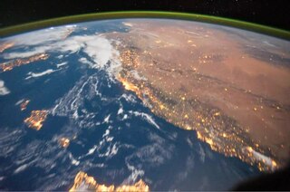
English: This video was taken by the crew of Balearic Islands show up well before the deserts in northern Africa. The darker patches seen through the Libyan Desert are rock outcrops amidst miles of sand dunes. The pass ends over central Africa, as forested areas begin to appear in a more moist atmosphere . |
| Date | |
| Source | The Gateway to Astronaut Photography of Earth |
| Author | ISS Expedition 29 crew |
Licensing
| This file is in the public domain in the United States because it was solely created by NASA. NASA copyright policy states that "NASA material is not protected by copyright unless noted". (See Template:PD-USGov, NASA copyright policy page or JPL Image Use Policy.) | ||
 |
Warnings:
|
File history
Click on a date/time to view the file as it appeared at that time.
| Date/Time | Thumbnail | Dimensions | User | Comment | |
|---|---|---|---|---|---|
| current | 17:36, 1 November 2011 | 37 s, 840 × 560 (10.22 MB) | Originalwana | {{Information |Description ={{en|1=This video was taken by the crew of Expedition 29 on board the International Space Station. The sequence of shots was taken October 15, 2011 from 02:22:10 to 02:41:01 GMT, on a pass |
File usage
The following pages on the English Wikipedia use this file (pages on other projects are not listed):
Global file usage
The following other wikis use this file:
- Usage on blk.wikipedia.org
- Usage on bn.wikipedia.org
- Usage on eo.wikipedia.org
- Usage on gu.wikipedia.org
- Usage on hak.wikipedia.org
- Usage on la.wikipedia.org
- Usage on mni.wikipedia.org
- Usage on ne.wikipedia.org
- Usage on sd.wikipedia.org
- Usage on tl.wikipedia.org
- Usage on uk.wikipedia.org