
File:Aylesbury Vale UK local election 2011 map.svg

Size of this PNG preview of this SVG file: 562 × 599 pixels. Other resolutions: 225 × 240 pixels | 450 × 480 pixels | 720 × 768 pixels | 960 × 1,024 pixels | 1,920 × 2,048 pixels | 1,187 × 1,266 pixels.
Original file (SVG file, nominally 1,187 × 1,266 pixels, file size: 890 KB)
| This is a file from the Wikimedia Commons. Information from its description page there is shown below. Commons is a freely licensed media file repository. You can help. |
| Description |
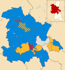
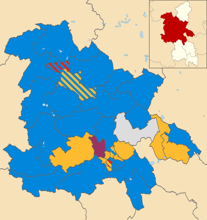
Map of Aylesbury Vale, Buckinghamshire, UK showing the results of the 2011 local election. Colours: Conservative
Liberal Democrat
United Kingdom Independence Party
Labour
Independent
Striped wards have mixed representation. |
| Date | (UTC) |
| Source | |
| Author |
|
.svg)
I, the copyright holder of this work, hereby publish it under the following license:
This file is licensed under the Creative Commons Attribution-Share Alike 3.0 Unported license.
- You are free:
- to share – to copy, distribute and transmit the work
- to remix – to adapt the work
- Under the following conditions:
- attribution – You must give appropriate credit, provide a link to the license, and indicate if changes were made. You may do so in any reasonable manner, but not in any way that suggests the licensor endorses you or your use.
- share alike – If you remix, transform, or build upon the material, you must distribute your contributions under the same or compatible license as the original.
Original upload log
This image is a derivative work of the following images:
- File:Aylesbury_Vale_UK_ward_map_2010_(blank).svg licensed with Cc-by-sa-3.0
- 2011-04-24T20:44:11Z Nilfanion 1187x1266 (910088 Bytes) {{Information |Description=Map of Aylesbury Vale, Buckinghamshire, UK with electoral wards shown. Equirectangular map projection on WGS 84 datum, with N/S stretched 160% Geographic limits: *West: 1.15W *East: 0.52W *North:
Uploaded with derivativeFX
File history
Click on a date/time to view the file as it appeared at that time.
| Date/Time | Thumbnail | Dimensions | User | Comment | |
|---|---|---|---|---|---|
| current | 07:46, 9 June 2011 | | 1,187 × 1,266 (890 KB) | Davewild | {{Information |Description=Map of Aylesbury Vale, Buckinghamshire, UK showing the results of the 2011 local election. Colours: {{legend|#0087dc|Conservative}} {{legend|#fdbb30|Liberal Democrat}} {{legend|#993366|United Kingdom Independence Party}} {{lege |
File usage
The following pages on the English Wikipedia use this file (pages on other projects are not listed):
Global file usage
The following other wikis use this file:
- Usage on es.wikipedia.org
- Usage on www.wikidata.org